
CIVILIZATION SITES & WATER TOO
Report #076
October 25, 2004
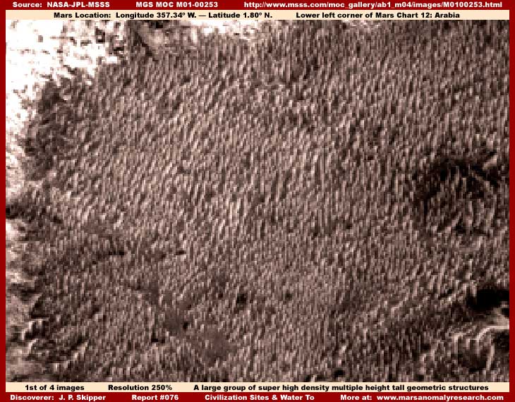
All evidence here comes from the MGS MOC M01-00253 narrow-angle strip. The above first image is a scene of a very large group of thickly packed super high density multiple height tall geometric structures. This kind of terrain level geometric structure evidence at the very minimum points to artificiality and beyond that it is very suggestive of civilization city building structures in massive numbers.
The structures are very likely in rows not readily apparent here in this first image because this more side view angle doesn't readily reveal that and the structures being so densely packed makes it very hard for the eye to pick out any individual object detail out of this great dense mass. Further, it is distantly seen with poor basic visual resolution requiring a fair amount of zoom factor so that we can see only basic outlines and that makes it even harder to pick out individual objects.
Even so, if you will get your eyes down close to the screen and look very close trying to focus on individual objects in this mass, you will see that this is indeed a great dense mass of multiple height tall individual geometric rectangular structure outlines complete with vertical sides, right angle circumferences, and flat tops. Certainly, there is nothing here in this evidence that can be confused with natural geology of any kind. If this is only a small portion of immense civilization city site, as I suspect that it is, it gives a new meaning to the term "high density."
This type of evidence is very similar to that in my previous reports at the links below and reinforces the relative plentifulness of this type of evidence on Mars.
Report #039
titled "Massed
Buildings in Precise Cross-Row Patterns"
Report #048 titled "City
in the Great Rift System"
Report #051 titled "Mars
Super Metropolis"
A few have argued that this type of evidence is the result of too much zoom factor in my imaging and over pixelation where the underlying base digital pixel grid starts asserting itself by beginning to force the edges of the smallest objects into right angle geometric forms. Sounds reasonable on the surface but it is simply not true. Since I have explained this in the above linked previous reports, there isn't really any reason to spend more time explaining it here again. Still, I've done so again below highlighted in tan color text. If you know the explanation and/or you're not into more technical information, skip over the tan text section.
All one has to do to prove this to oneself in this particular strip is look at the original GIF image strip. Do not use the JPEG compression strip because this lesser resolution format can have a tendency to introduce JPEG artifacts and square some information sooner in the development process whereas the greater resolution detail in the GIF compression resists this.
In the GIF strip look very close. At the normal official resolution, although very tiny in size, the objects in question can still clearly be seen to be geometric forms having right angle qualities and patterns AT THIS BASE OFFICIAL RESOLUTION LEVEL. Gradually increasing the zoom factor in stages up to the 250% I've used and clarifying the image merely enlarges the basic geometric aspect of the structures that is already there and changes or alters nothing.
However, if one goes to as much as 300% zoom or greater, the true pixelation effect on the structures does begin to become visually apparent and recognizable. This clearly demonstrates the zoom factor point at which over pixelation does actually begin to become a factor and my image work stops well short of this point. So what you see here is very real and true ground detail.
The only thing that I want to caution those attempting this test is that you will need to use the third listed straight GIF strip as the second listed sinusoidal (angled) orientation GIF image does not work. The problem is that the third listed straight GIF strip has been flipped vertically and horizontally at official level before being released. This can (and does in this case) introduce far too much distortion in the image. The true non distorted orientation view is demonstrated in the first listed JPEG image and verified by the accompanying M01-00254 wide-angle context image. So you will at minimum need graphics software to flip the straight GIF image to the correct non distorted orientation view in order to start to test and duplicate my results.
Flipping the straight GIF image was often done in the earlier MGS MOC images and was apparently never caught in peer reviews and/or it was just simply intentionally allowed through. I suspect that this was used as just another one of many intentional obfuscation tactics. You see, most scientists not realizing this and having fast Internet download connections will prefer to scan the straight GIF image strip for its convenient, faster and easier up and down scrolling advantage. I doubt that many of them understood that they were looking a flipped distorted image that would of course cause havoc on any "unacceptable" smaller detail that might make it through the usual more direct tampering applications.
Most of this strip has a lot of sites similar to the city structure evidence presented here. They appear as smaller sites than this one in my first image above but only because broad areas of carpeting image tampering surround, confine and isolate them as well as mix up within them partially obscuring their visuals. So, a great deal more of the same type of city structure evidence with likely larger more recognizable objects are probably being mostly visually hidden from our view by tampering fields. That suggests that most of this strip is part of just one giant civilization complex of very high density covering an area much greater than the strip itself.
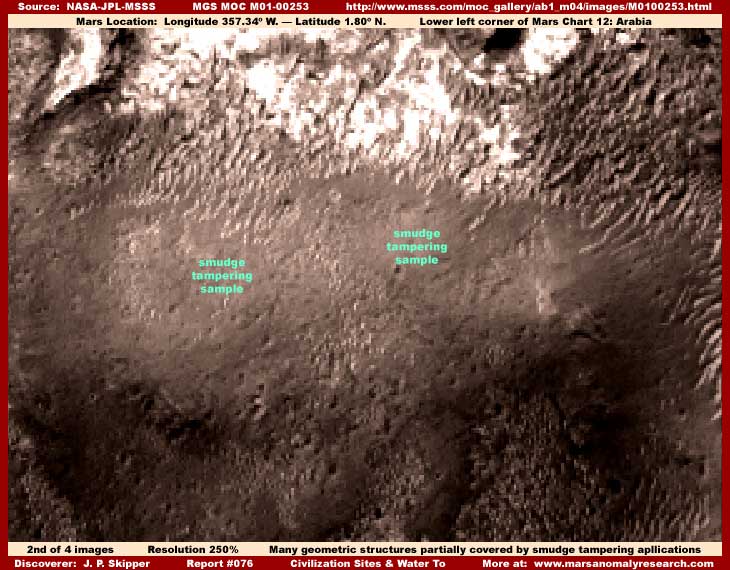
The above second image of a site nearby the first image site demonstrates a typical scene in this image strip where geometric structure detail evidence has been mostly and partially covered over with darker color dithering smudge tampering applications. I've labeled in green a couple of representative sample areas of the overlaid tampering applications. Even so, you can clearly see the same geometric structure mass detail peaking out from under many places and gaps in the covering tampering application. Enough at least to clearly see what is really going on.
Note to that a large patch of some geometric structure detail has been left out of the tampering and is more in the open in the upper right corner area of the above image. Because of the now more favorable angle, the row pattern typical to this kind of Mars evidence can now be seen and recognized better. Note to that the row pattern lines cross the image's base fixed pixel grid at a pronounced upper right to lower left ANGLE defying the influence of the underlying rigid vertical/horizontal digital pixel grid and clearly demonstrating that this evidence is NOT subject to being shaped by that pixel grid and over pixelation problems.
The provided official resolution in the strip is so distant and all this evidence is so tiny in size in that provided resolution that it leaves the impression (by intent) of more natural appearing terrain when seen at that officially provided distant resolution. Only by examining this evidence much closer at this increased zoom factor can it be determined what it truly is. This closer view has been enabled by the use of the GIF imaging providing more resolution and detail. Compare that with the much closer JPEG imaging from the Spirit and Opportunity Rovers that is intentionally so severely compressed and lacking in resolution detail that none of this kind of closer examination of evidence is possible.
The tampering direct applications more specific goal here in these satellite images is to hide the larger more identifiable evidence as well as break up the identifiable artificiality patterns native to this geometric structure evidence. It is also routinely done on such a massive scale in so many tens of thousands of satellite images even when there is nothing to hide because it serves to generally condition the perceptions of those in the "not need to know" loop within the science communities and elsewhere to interpret and accept the false tampering patterns as natural terrain for future identification reference, even though they are often visually just featureless "stuff" devoid of any real natural terrain detail at all.
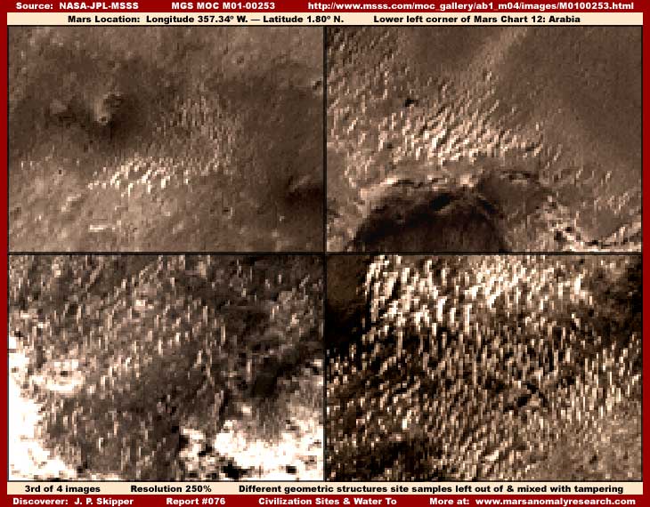
The above third image gives just a few samples of the many smaller geometric structure detail sites in this strip. In these images, you can see how the dithering smudge tampering applications surround these smaller sites visually confining and isolating them even though they are really part of a much greater sprawling whole. If you will look very close, note that you can see fairly well here how the tampering also extends up into and mixes in with the structures in varying degrees attempting to further confuse the visuals and break up the more recognizable geometric artificiality patterns.
This finer detail tampering work is enabled by those doing it working with the true much closer and much higher detail science data imaging that is never released to anyone outside the secrecy circles. This finer detail tampering evidence is in fact how we know positively that such closer imaging does exist. They then draw back to this much more distant view and further degrade the resolution so that trying to examine this kind of small geometric evidence closer is very difficult to do. If the small size of the individual objects city structure evidence doesn't leap out at you as being very obvious, I am sorry but this is all the resolution and detail they have left us to work with.
To give you and idea of what resolution we have a right to expect here in this Mars imaging, you should have a sense of comparison. This kind of Mars satellite imaging as seen through very little obscuring cloud/weather cover versus satellite imaging of a major Earth city and some of its downtown building structures as seen through normal Earth obscuring weather cover. This particular Mars imaging is some 240.92 miles or 387.71 km distance from the terrain based geometric structures.
Now in my report #055 titled "Towers in the Sun," please note the fifth and last image in that report of a portion of a major Earth city taken from over 400 miles distance via just regular commercial quality digital satellite imaging. Note the dramatic difference in clarity even though the imaging is through the Earth's much thicker obscuring atmospheric envelope and the distance is a great deal further away from the target than on Mars. This is the kind of evidence that also tells us that many times better satellite imaging is withheld from us and retained somewhere in secrecy. Sorry but no one is going to convince me of the illogic that we went to all the trouble and considerable tax payer expense in the many millions of dollars to send lesser digital camera systems to another world like Mars producing at its best the kind of science data poor imaging you see here.
However, even though this Mars imaging is a very distant view without very much in the way of individual object detail as released to us, no doubt by design, a number of specific details can still be determined. For example, these are all clearly tall to extremely tall narrow vertical straight sided towers very similar to large downtown Earth city high rise buildings, only more so in every respect. They are generally all the same width-thickness-circumference even as they are in a great many differing heights. They all appear to be flat sided and either rectangular and/or octagon shape in design. All are in the open and none appear to be under any kind of cover protecting them from Mars' allegedly very cold and thin atmospheric conditions.
This kind of evidence and others like it clearly implies that Mars is likely very heavily populated and by an advanced civilization or civilizations typicalized by collecting into massive super high density sites. It also demonstrates that Mars is not likely as cold as officially reported nor does it have as much very thin atmosphere to the harsh degree officially reported, or else alternatively someone on Mars is physically and/or technologically well advanced and adapted to its harsh climate. My liquid surface water discoveries held back for inclusion in my first book indicate more moderate temperatures than officially reported and that tells me that it is likely the former scenario rather than the latter that is true.
Your question might then be, if they are so many and so advanced, why hasn't someone from Mars contacted us? My counter is also in the form of a question. Who is to say that they haven't? Certainly, if so much deeply entrenched hard secrecy surrounds revealing their mere existence, the secrecy associated with any contact would logically be even more intense. The real question here is do you really want to know??? Is so, are you willing to get involved in sufficient numbers to make your demands heard and count?
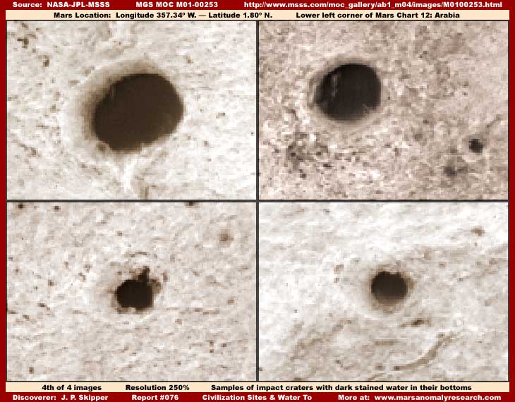
This strip isn't just about city and civilization evidence, it is also about some theoretically impossible (according to official positions) Mars liquid surface water. In my previous reports linked to below, I've introduced the concept of dark stained liquid surface water on Mars and why it is so. You may want to at some point bone up on this concept in these previous reports for better more informed interpretation of the above four dark stained water sites.
Report #057
titled "Water
Ice Masses: Ecology's of Life"
Report #075 titled "Water
Ice in Fractured Stratified Layers"
The above fourth split screen image demonstrates some sample impact craters with what appears to be level dark stained water in their bottoms. I do believe that the three images upper left, upper right and lower right with a faintly seen measure of translucent quality do represent liquid water. However, the lower left crater I suspect may actually be dark image tampering covering something there and may not represent water. Note the straight right side of the dark area within this crater and its dark blank flat featureless quality as compared to the more translucent quality in the other three craters. This may not be natural to the crater bottom and may be an artificial somewhat careless tampering application.
You should probably know that the bottoms of smaller to medium size craters in the MOC imaging are often routinely covered with false blank darker splotch areas like this one as well as others with fake patterns in them like mimicking dunes, ice or ridge forms as part of the overall tampering strategy. Some of this is to hide evidence while some is designed to condition the eye to accept this plentiful if false detail as normal and natural in the Mars terrain. I haven't reported on this before because I tend to forget that what I as a research investigator see so much of and perhaps take for granted, others may be unaware of.
However, an examination of the many images of this general region on Mars where this image strip comes from converging in the corners of four different Mars Charts reveals a great many craters of varying sizes with dark stained water in the bottom that does appear to be genuine. Even very small to outright tiny impact craters show the presence of this dark stained water in them and of course there is the usual wide spread false tampering in so many of these crater depressions. It is this experience with this general region that also contributes to me presenting to you the above representative surface water sample sites from this one strip as true surface water sites.
Apparently, underground dark stained water is very close to the surface in this region. Further, some more recent impact craters show the presence of dark stained ejecta patterns radiating out from the crater center hit area that also suggests dark liquid or mud as part of the ejecta component in a splattering outward effect. This M01-00253 strip does demonstrate some of these as well. Where liquid water is more readily available, life can be expected to collect in the area and take advantage of it. Further, as I have previously reported in the other previous reports linked to here, the dark stained water itself is an indicator of the life organism within it that gives it its characteristic dark stain.
As craters go on Mars, the ones above with water in them are relatively small. However, they are still large enough with dark enough bottom areas to overcome to some extent the severely degraded resolution of this strip in the light reflective areas where this water is found and allow a halfway decent look at this evidence. The test of the degree of how degraded the resolution is in this strip is the lack of any real terrain detail in the light reflective terrain surrounding these craters.
So, in this strip, we once again have a lot of small size evidence highly suggestive of very densely packed tall city building structures and even some dark stained surface water to. The anomalous evidence is clearly there, so why aren't the scientists investigating it and why aren't our world leaders demanding that it be investigated by them as well as demanding the release of the true higher detail tampering free satellite imaging held in secrecy that would enable such an investigation to get the needed truthful results?
So what's up with us? Are we just a world civilization of collective puppets with dulled brains so that we really don't want to know anything we don't want to know? Are we held prisoner by our own emotional fears and anxieties where rationality and reason has no chance to provide enough significant balance? Are we box people who just can't think about anything outside the box prescribed for us by a few trying to control us?
DOCUMENTATION
http://www.msss.com/moc_gallery/ab1_m04/images/M0100253.html: This link accesses the early MGS MOC M01-00253 narrow-angle science data image the evidence in this report was drawn from. Note the first listed faster loading sinusoidal projection JPEG strip is sometimes problematic loading and anyway has lesser resolution and detail for seeing the very small evidence. The second listed sinusoidal GIF strip does not work. Use the third listed straight GIF but note that it has been flipped at official level and you will need graphics software to flip it back both vertically and horizontally to match the true original orientation. The geometric structure evidence is in darker upper half of the strip and the water evidence is in the lower more light reflective half.
http://www.msss.com/mars_images/moc/2004/10/12/: This link accesses the MOC2-877 image released on 10/12/2004 by MSSS as a human interest captioned public release using a small portion of the much larger M01-00253 science data image. It just basically identifies a site in the strip where the letters and word "hi" are sort of spelled out in the terrain, that is if you stretch your imagination quite a bit. Not much to it but it is associated with this image and I include it just in case you wish to look at this feature.
NOTE: Here is a secret. Some of the earlier MGS MOC images must be handled very carefully in the save and development process to preserve fine small detail. This M01-00253 image strip is one of those.
Careless saving and subsequent development work will result in an overall rounding of small separate geometric rectangular sharp right angle detail causing it to loose its geometric quality and giving it a false soft rounded lumpy look that merges with adjacent detail running objects together forming new false shapes. I suspect the secrecy types routinely utilized this booby trap in the science data as one of their tampering tools to destroy small size detail in certain specific images and create new and false subtle shapes via the rounding and merging process.
The legacy of this in the satellite imaging is that this critical alteration of small detail is very subtle, hard to catch, easy to do and mess up on, and many on the Internet unknowingly present Mars evidence with this problem. To verify behind me on this particular city structure evidence, save the official GIF strip file initially to your hard drive as a GIF file without any alteration. Then open it up there, crop out the area you want to work with, change the Mode from Index Color to RGB, increase this image size to 250% in this case, and save as a PhotoShop PSD or BMP format file to preserve quality even though this will result in larger file sizes.
Now the small size evidence should be preserved and not altered and you are ready to do what ever additional work in it you desire without risking destroying any tiny size geometric evidence detail. Working with the image differently, even just blowing up the image zoom wise alone, will trigger this booby trap and destroy small size evidence geometric detail.
, Investigator
![]()