
CITY IN THE GREAT RIFT SYSTEM
Report #048
February 4, 2003
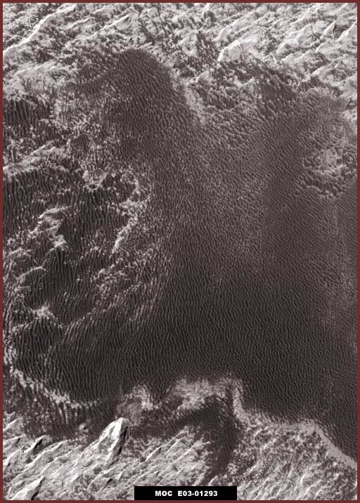
The above first image represents a section out of the MGS MOC official E03-01293 strip of this anomaly site just as it appears from one side edge of the strip to the other in the original science data 100% view and without any enhancements by me. Note that this anomalous site is located down in the middle upper area of the great rift system on Mars, more specifically identified as northeast in West Candor Chasma. Note to that this is a fairly typical width official strip we're dealing with here of average size and resolution.
The broad dark area in the above #1 image is the anomalous site being presented here for your attention. It looks kind of strange doesn't it while the rest of the terrain looks relatively normal as a series of rough ridges and valleys. This dark area sort of reminds me of some strange fur or the growth of something following the contours of the land. Obviously, at this limited official resolution size and since the scene is not typical of anything familiar here on Earth, who would suspect that the dark area is actually the only thing real here and that it actually appears to represent a high density city scene full of artificial rectangular structures, just seen here from a great distance. It certainly doesn't look anything like that but then that is a perception manipulated purely by design and intent as this scene has been crafted to that purpose for presentation at the official resolution level.
Even though the light color areas north and south of the dark area look like very normal ridge and gully geology, this is actually an illusion created by heavy creative image tampering in those areas. The tampering serves multiple purposes. The most obvious is of course to directly cover civilization evidence. Additionally it also destroys any natural terrain geology that might serve as true frames of reference in this strip and this prevents the viewer from being able to accurately determine true size scale here and therefore determine the true very distant resolution actually being used. But that isn't the end of it, the creative illusion of a more familiar but false size rough ridge and gully/valley terrain also molds a false perception of size scale expected to be seen. If one accepts the false light color ridge and valley terrain as real, then one expects any possible civilization evidence to coincide with that size scale. Since nothing is seen at that expected size scale, then there is logically nothing of interest there. This is how perception is manipulated to a desired but false end. Very slick but the real truth is that this scene is much more distant than it initially appears and reported in the official statistics.
I've elected to show some of this more difficult to interpret type of evidence to you rather than doing my usual thing of passing it up as too difficult for too many viewers to unravel. One reason is because the type of tiny civilization evidence here is somewhat similar to that in my last report and I'm admittedly trying to capitalize on any familiarity gained that may have come from that previous report. Another reason is that the slightly rounded or humped terrain under the dark areas in the first above image tends to throw some of the rows of tall upright densely packed rectangular structures slightly at an angle to the side from the overhead satellite camera view giving a slightly better interpretive look at them than is usually the case. In the usual straight down view with the rows seen from high above and on end, tall similar height high rise structures and their roof tops present a smaller footprint at the very distant official resolutions provided and their row orientation tends to blend them in together forming continuous chains or lines that merges into a confused jumble or into a simulated natural ridges look quicker (with some help from creative tampering) and is much harder to recognize as to what this type of evidence really is at official resolution.
Also, for some reason, the usual prevalent direct application image tampering isn't as thick on this particular dark area part of the cityscape even though it is very thick and very heavily done around it in the light color areas and in the rest of the strip. I can only speculate that, if someone didn't rebel and purposefully leaves this patch out of the tampering, the secrecy types may have thought civilian viewers and most scientists would not be able to recognize this particular scene for what it really is. The only thing that is seriously affecting the dark area visuals in this scene is base pixelization treatment applied at official level before the data was released to the public causing a doubling blur effect along the linear and right angle lines of the structures preventing a clear view. This has also affected the light color heavy tampering areas severely with a obscuring glare effect but is much less in its effect on the darker area structures typical of light versus darker objects in satellite imaging.
Also, for some reason, the usual technique of drawing back further to a sufficiently more distant resolution on tiny size evidence like this reducing it to even a smaller even more tiny size that in turn causes individual objects to merge together so blowing it up will reveal little also hasn't been done enough to completely destroy the evidence as is usually the case. This has allowed us to get a little better zoom factor than is normally the case without compromising the evidence with too much pixelization. The general net effect of all these various factors together is to give us a bit more decent look than usual of this kind of evidence in the dark area that is usually thoroughly obscured by multiple different image tampering treatments.
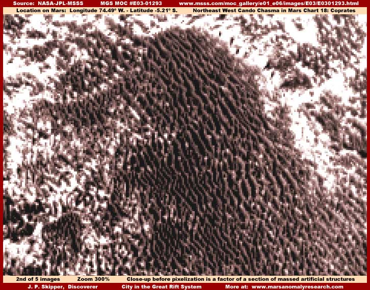
The above second image is a closer 300% zoom view of the dark humped terrain area in the center top of the first image here. Don't be content to just sit back and view this, get closer to the screen and inspect the darker area closely and carefully. While the row after row of tall upright high rise densely packed rectangular structures isn't as obvious as we could wish for, it is usually much worse due to the many kinds of tampering normally associated with evidence like this and we are fortunate to have a view like this at all. One can even see that many of these distantly seen structures are of differing heights.
Also, you should be aware that the file size is abnormally very high on this image scene verifying that the software is seeing just what we think we are seeing, very high numbers of individual surface level densely packed hard objects with gaps in between them. The lighter areas are less clear here because the objects there with all the heavy tampering are light color with too much reflectivity that blurs and blends them together. Add to that the base pixelization doubling blur effect accentuating the light color over saturated obscuring glare. Further, add the fact that I've put contrast on this scene to sharpen up the dark area detail with its better viewing potential and this has also come at the cost of over saturating the already harder to see detail in the light color areas and caused a further increase in obscuring glare reflectivity. This can't be helped if the dark area structures are to be seen adequately.
This scene with all these thousands of rectangular shaped tall hard objects obviously and clearly has no parallel at all in any known natural geology! Therefore there is no adequate natural geological explanation for what we are seeing unless someone starts grasping at straws with explanations. Further, as you will discover upon further reading below, when the whole wide area is blown up to this 300% zoom factor, there is no pixelization present in other smoother areas clearly demonstrating that these great many rectangular objects are true detail on the ground and not associated with the base pixel grid system of the digital image. Additionally, as you can clearly see on close careful examination, these many rows of rectangular objects meander just a little and follow contours in the terrain surface under them as well as form row patterns completely contrary to any rigid uniform digital pixel grid system. In other words, there can be no mistaking that this is true ground level detail.
I know that it is a struggle for some of you as acknowledgment of this type of evidence goes against previous deeply embedded belief systems as to what you thought you knew about Mars and may even be interpreted as a bit scary. But, this is just what it appears to be, a portion of a massive city with densely packed high rise multiple height tall rectangular structures, just seen at a great distance. At some point, all but a die hard few are eventually going to have to come to the full realization that evidence like this is not a prank, not entertainment, and not something created by some weird crackpot person out there, but hard visual evidence based on determined objective research drawn directly from the official science data and thoroughly supported by that data. Remember, I do not make this evidence, only report it as it presents itself and at some point we're all going to have to come to terms with this.
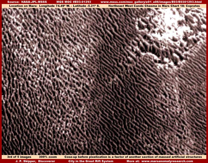
Here we go again in the above third image of another different close 300% zoom view of this dark area city scene but just a little down and to the right of the above second image scene. It is in the same dark area demonstrated in the first image here, just a different section of it and again with the advantage of a little side view angle. Further, as dense and thick as this city evidence is, note that it is still only a small portion of the dark area you've seen in my first wider area image and note again that this dark area is itself also only a small portion of a much larger metroplex that extends far out under the light colored illusion tampering and off the edges of the full official image strip.
Now don't let others driven by fear, closed minds, and/or convert secrecy agendas confuse you that what you are seeing in these closer zoom images is too much imaging pixelization with too much zoom factor placed on it by me forcing visual rectangular shapes. Take note of the subtle angles and slight bow curves of the row upon row of structures and the fact that this does not in any way coincide with the rigid uniform pixel grid that forms the bases of all digital imaging. Look very closely and you will see that there are long lines of similar height structures but also many even taller multiple height high rise structures as well. This again defies the base underlying rigid uniform digital imaging pixel grid.
Further, to put it over the top, the abnormal unusually very high file size on the above second and third images here is itself revealing and telling factual evidence and proof that what we are are really looking at here is just what it appears to be, true Mars terrain surface level detail consisting of thousands of hard surface tall rectangular objects. The human eye can certainly be fooled by the visually creative and obscuring tampering applications and this is reinforced by the lack of familiarity with the unusual appearance of another world's civilization evidence that does not follow familiar Earth patterns. However, the software cannot be so easily fooled and sees and records all just as it truly is, including right through the visually obscuring tampering overlay to the true information detail below it. The abnormally high file size is directly due to the super high number of individual hard surface objects and gaps between them it sees and counts across the base pixel grid.
If it ever comes to a rigorous objective examination and debate, you can bet on it that a comparison of image file sizes between known natural rough higher detail Mars terrain and this kind of highly anomalous Mars terrain will quickly demonstrate that this is true ground level detail substantially and dramatically intensified by the number count of the densely packed hard surface rectangular structures seen here. Why have I have noted this where other legitimate researchers without hidden agendas have not? It's probably just that I happen to be more aware of this factor simply because of all of the research imaging that I do in the thousands and dealing with so many same size images for my particular style of presentation that provides this kind of comparison opportunity from same physical size image to image that other researchers may not have indulged in. This is another form of research testing that I have intentionally chosen simply because it does afford the opportunity for this kind of comparison testing of information.
Again I remind you that this huge metropolis is far larger than what appears even in my first wide view image here. Actually most of this strip is occupied with this type of evidence continuing on off of the strip sides and bottom. It is just that the combination of light and dark mixed together object specific image tampering in other broad areas is very heavily applied and has made very good on its attempt to mimic and create the illusion of natural ridge and valley terrain. However, when we do recognize and take this creative but false illusion image tampering factor into consideration, one begins to realize the full extent of the huge massive cityscape is far larger than the dark areas imaged here, larger in fact than the entire official image strip itself, and far beyond anything seen on Earth.
Such a concept may not suit some viewers psychology, convenience, and desired belief systems due to growing awareness of this kind of information's full implications and ultimate impact but the only other alternative is avoiding perception of truth and reality and living in pretense. If indulged in, such self imposed ignorance in no way halts the steady march of reality or any real time factors associated with it and is therefore no answer at all. Ultimately such a choice always carries with it the seed and potential for some eventual very bad end results as reality eventually and relentlessly has its way.
Where the size and basic shape (all we can see) of the individual rectangular structures is fairly familiar to us, their grouped orientation in these long parallel rows is not something that we are familiar with here on Earth where city buildings tend to be grouped into rectangular grid patterns or blocks. Our city building block patterns are mostly a function and heritage of the need for reasonably efficient ground transport access (streets & roadways) but perhaps that need does not dominate on Mars. Also, this may be purely a function of the differences in esthetics and/or culture legacy to. I also suspect that being on a grade has quite a bit to do with it to and shallow water distribution flowing down that grade accessing the base of these structures may also be a strong part of this scenario. This last factor of civilization Mars civilization evidence seen occupying slopes both naturally occurring and artificially made associated with shallow water flows and in rows seems to be predominant theme in a great deal of the Mars civilization centers evidence.
I have seen so much of this row pattern evidence at the limit of resolution, far more than I report simply because it is most often too tampered with and too distant to be clear enough to present to you but not so destroyed that I can't learn from it in bits and pieces establishing a growing knowledge base. Based on that growing experience, I can tell you that the multiple row pattern of densely packed rectangular structures you see here is frequent on Mars rather than a rarity. This is especially prevalent in areas near and on the South Polar Ice Cap ice fields along with rounded oblong forms where structures cluster in the center and expansion takes the form of rings on the outside edges.
At the South Pole, this kind of massed lines of rectangular structures evidence, as no doubt viewed by the secrecy types in much closer resolutions not released to the public, frequently receives covering blur and fog/smudge image tampering down the length of and blotting out several very long parallel and adjacent rows leaving one or two long parallel rows partially visible and then down the length of several more rows leaving another row or two out and on and on like that over and over again. The resulting parallel rows with blank gaps between them left visible usually also have color coordinated object specific direct image tampering applications on them to creatively make their long lengths merge and blend together to look more like terrain ridge lines rather than the artificial rectangular structures they actually area.
The net effect is to blot out the bulk of the civilization evidence completely from view and leave only long strange lines of parallel terrain looking forms as seen at the official released very distant resolutions with these wide flat featureless interspaces between them created by the blot out fog/smudge image tampering applications. While the wide apart long slightly meandering parallel lines look strange and do draw attention to themselves, the bottom line is that they still also look enough like strange terrain forms and a whole lot less anomalous than huge fields of the kind of rigid pattern evidence so suggestive of artificiality you see here in this report in the dark areas. In other words, it's all about tradeoff and the illusions have so far been good enough to fool just about everyone.
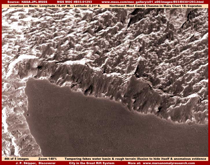
The above fourth image is of a scene right at the bottom of the official strip and represents just how effective the creative illusion tampering in this strip is. Note the very natural looking rough low ridge and gully terrain surrounding a large depression with a dark uniform flat level surface very suggestive of a liquid and with a irregular shoreline also very suggestive of terrain sloping down to and bordering on a liquid. Note how effective the shoreline is and how it follows faithfully the in and out irregular contours of the "land" where it meets the "liquid." You should know that the flat and level "lake" looking surface is much smoother as seen in the original official 100% size view than seen here and the visuals there are more suggestive visually of a liquid in a natural geological depression area.
However, the above fourth image with my increased 140% zoom factor and some clarity enhancements have partially defeated a small part of this level surface "treatment" revealing the existence of a faint bumpy pattern out on the flat level "lake" surface. This bumpy pattern clearly demonstrates that this is not a liquid at all and is the clue to unraveling what is really going on here in this scene. The question is, if not a liquid surface, what is it? Is it still explained by natural geology as an ancient sediment mud flat now exposed by the elements, an old pooled and hardened volcanic liquid rock flow, a depression filled with blown sand that has leveled out, or some other natural geologic feature?
The correct answer is no. The fact is that there is little real about any part of this fourth image illusion scene at all! For example, the terrain above the depression in the upper part of this fourth image that looks so natural as ridge and gully or valley systems is in fact tall structures running in rows at an angle from right to left. A light color but heavily done smudge tampering direct object specific application coating has been applied horizontally along their side lengths and especially across their top lengths causing individual structures to merge and blend into forms creating the illusion of rough ridge and valley terrain. Many small and larger daubs of mostly vertical oriented darker smudge direct tampering application are sprinkled all over this to break up so much light color, create a more mixed and vertical look enhancing the rugged terrain appearance.
If you have a good eye and examine very close, you can still see a few structures sticking out all over this upper light color area that are obscured by dark tampering applications. Although the net visual effect is completely illusion, it is extremely good, hard to detect, and excellent very effective workmanship provided it isn't examined too closely and with a suspicious eye. This is what a great deal of your tax dollars has been paying for. Doesn't it give you a warm fuzzy feeling?
The dark level depression area, although very well done, is itself completely faked but with some mistakes that reveal it for what it really is. The dark level surface is a broad dark smudge application thoroughly covering up and flattening out something there. But, the application isn't quite thick or dense enough to completely blot the structures out and a small amount of structure tops pattern prints through to the surface when my clarity enhancements reveal it. Likewise, the shoreline and slope down to it is actually also entirely a optical illusion created by a dark shorter sweep type smudge tampering in a consistent directional pattern oriented toward the "water" and therefore creating the slope to water and false shoreline appearance.
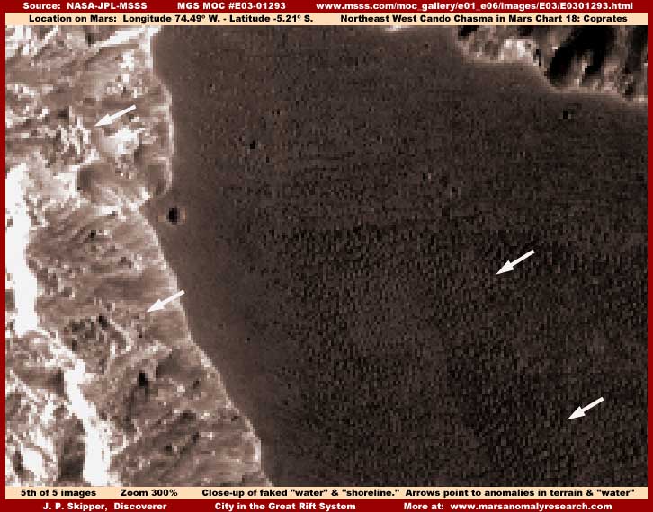
The above #5 image of the "lake" at a 300% zoom factor better demonstrates the knobby hard object pattern now more clearly printing through the "lake" surface with sample areas pointed out with the two arrows on the right. While these can't be conclusively identified visually as rectangular structure tops, the increasingly obvious tampering application itself that usually always hides civilization evidence makes it logical to seriously consider that such civilization evidence is a very high probability here. Further, the unusually high file size of these last #4 and #5 images like my previous second and third images above also confirms this.
The other two arrows to the left on the shore and in the faked slope area also points out some more obvious partially obscured by tampering small groups of tiny but tall high-rise rectangular structures sticking out of the tampering application and not completely covered by it. Those groups of tiny rectangular structures matches size wise the massed rectangular structures in my second and third images here (also at 300% zoom) and, if these are buildings as they appear to be, that in turn gives us a clear size frame of reference as to how distant this scene actually is despite the very successful attempt of the total tampering effect in this strip to destroy all comparison frames of reference and create illusion size frames of reference to support official statistics and the lack of anything anomalous false perception.
You can also now better see the streaks giving away the sweep or brush applied type of dark image tampering applications that create the faked directional slope down to shoreline illusion. Please also note the pixelization blur that is prominent and especially acute in light color areas around rectangular structures with their linear and right angle straight lines including right up to the "shoreline" edge. This is a doubling blur effect done by mismatch overlap transposition of the scene down at pixel level and not something created by my 300% zoom factor. The proof of this can be seen by a very close examination of the flat level area smooth featureless dark fog/smudge image tampering application areas just off of the left "shoreline" out to the right in the "water" area where you will not see any of this pixelization even though it is immediately adjacent to the heavy pixelization at the shoreline edge.
Since this is part of the same image strip and seen at the same zoom factor as in my second and third above images, this difference between the shoreline edge with its heavy pixelization and the immediately adjacent dark level area lack of same demonstrates that my 300% zoom is also not a factor in forming any of the mass of rectangular shaped evidence in my second and third images cityscape evidence. Remember, since the image pixel grid is universally made up of same size pixel squares, any zoom factor of mine large enough to be seen in certain areas of the image, would also be a universal factor in the rest of the image. Where some evidence is effected and some not, as shown here in my #5 image, that demonstrates that any pixelization seen has been done at official level before the imaging was released to the public and then parts of that tampering effect area was later covered over by additional tampering layer applications being added over it in portions of the image and at different resolutions. This in turn demonstrates that resolutions greater than that released to the public do exist. The logic is inescapable.
The bottom line is that yes there is pixelization evident, especially in the left light color "on shore" areas of the last fifth image here, but this doubling blur effect does not itself create anything false in the view, only blur and partially obscure what real evidence is already there that is true terrain surface level evidence in the strip. So don't let others get you confused about this.
Meanwhile, what does the main civilization evidence like that in the second and third images here tell us about any possible civilizations on Mars? Well, so many densely packed multiple height rectangular structures in the open not under any apparent protective cover has many implications. We can't conclusively assume too much on such limited visual information but there is enough information for some reasonable speculation.
One clear implication is that there is probably a more breathable atmosphere on Mars than officially reported or at least one that whoever is on Mars has been able to adapt to and live with out in the open. It also implies that temperatures on Mars may be much warmer than we have been led to believe. My liquid surface water discoveries that I have been holding back and will be releasing soon as well as my experience with the thousands of bits and pieces of evidence that I've not reported on confirm and reinforce this probability. Now that is not to say that Mars is not cold, just not as cold as officially reported. Same with the atmosphere, it is thin as evidenced by the lack of very much atmospheric clouds but probably thicker than officially reported.
The civilization evidence and the good physical condition that it is in, both via the small amount reported on by me and the much larger body of small bits and pieces of my research experience not reported on, supports that the civilization structure evidence represents active functioning life and not the remnant ruins of long dead civilizations. The massive amount of image tampering in Mars and Moon imaging combined with the official essentially covert technology methods of Mars and Moon exploration rather than progressing more toward open manned flights to Mars and also to the Moon reinforces the viability of this speculation. Further, the massive presence and involvement of military intelligence and National Security at every turn in the space exploration command and decision making structure such as the presence of that top echelon Navy Admiral from military intelligence until recently secretly chairing the JPL oversight committee and controlling Mars exploration again clearly reinforces this concept.
The civilization evidence such as you see here in this report and in the previous one and the familiar shape of the individual rectangular structures so visually reminiscent of tall variable height high rise buildings here on Earth as seen from a great distance speaks of at least some similarities between humans on Earth and whoever is on Mars, even if the row orientation pattern of the structures does not. I know that this is very hard for many of you to accept but the very high density of the rectangular structures and the huge widespread areas they occupy, often far larger areas than here on Earth, speak of very high population density probably severely taxing the environment and natural resources. That speaks of successful and thriving dominance of one's environment and therefore of an aggressive civilization psychology but also one that has historically been unable to properly regulate its population density causing problems for itself and any other life associated with it. Does that scenario sound at all familiar?
This kind of speculation/extrapolation could go on but this one limited report is not really the place for all that, still you get the basic picture. The point is that, while those on Mars may be more technologically advanced than Earth populations in many ways and more sophisticated in many ways, don't prematurely come to the conclusion that they are any better than we are overall because they still appear to have many of our problems that should have been solved long ago, especially in light of their level of general advancement. Rather, whoever is on Mars is just different than we are and I suspect there is much that we could learn from them, if we have sense enough not repeat our own past many mistakes in meeting with and dealing with other new and different cultures and ideas.
SUMMARY POINTS
(1) ... This massed rectangular high rise structures evidence has no parallel in known natural geology.
(2) ... This massed rectangular high rise structures evidence is very characteristic of civilization evidence.
(3) ... Image tampering creating illusions of natural geology obscuring evidence are extensive in this strip.
(4) ... Such extensive image tampering means someone is well aware of the civilization evidence.
(5) ... Someone appears to be on Mars but no one at official level here is sharing this knowledge with us.
(6) ... Some living on Mars appear to be currently active, live in high density, and live in the open atmosphere.
(7) ... Living in the open atmosphere has undermining implications for official atmospheric science data.
DOCUMENTATION
In checking behind me to verify this evidence, the easiest source to access is at the MSSS website link below. Just remember though that, although the image strip is reasonably normal size, the evidence here is still tiny and you will need graphic software to zoom in, clarify, and see anything significant like the rectangular structures evidence and the image tampering pointed out here. None of the rectangular structures evidence can be seen without it as the official imaging resolution provided is too small. All three of the browser compatible strips at MSSS work and all have the same orientation.
MSSS ..... http://www.msss.com/moc_gallery/e01_e06/images/E03/E0301293.html
, Investigator
![]()