
WATER ICE IN FRACTURED
STRATIFIED LAYERS
Report # 075
October 10, 2004
This is a story of misinterpretation and/or misdirection as revealed by the official science data visual evidence itself. MSSS has pre-released MGS MOC image MOC2-827 (aka R19-00219) in a captioned text piece showing what at first appears to be many similar massive terrain forms on the North Polar Cap that are, in my opinion, incorrectly officially identified as sand dunes. You will see this R19-00219 visual evidence in further images below.
Almost every strange looking surface land form on Mars, and there are a great many different varieties dealt with in this way, is most often officially identified as "sand dunes" or just "dunes" implying the sand designation. This of course pushes the official Mantra theme that this planet is a very dry dead world. Many times they will even identify by misdirection dark tinted liquid surface water itself as "dark sand" collecting in depressions pushing this Mantra and trying to head off different interpretations even though lighter color land forms can be clearly seen under and THROUGH all this "sand." I don't know about you, but I've never seen sand solid particulate translucent enough to see underlying land forms through.
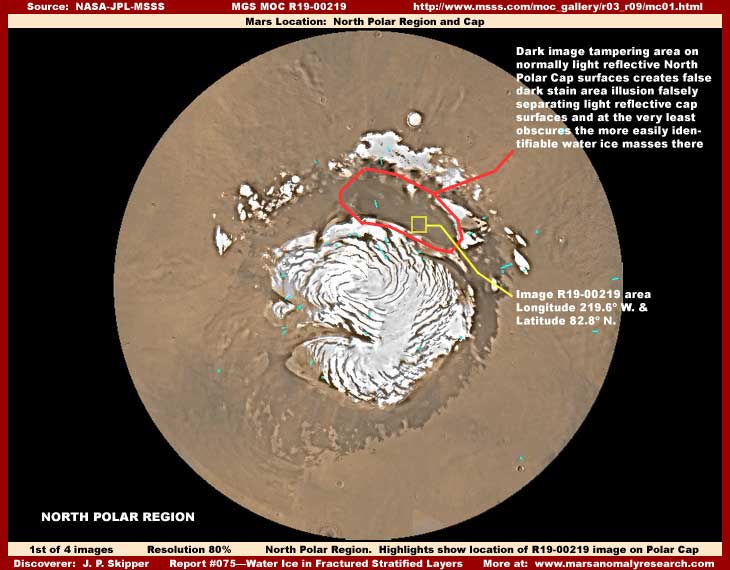
The above first image demonstrates the general location of the R19-00219 image in question here in the North Polar Region right on the Cap itself. I show you this location on the global map in an image here because the dark area within the red outline is an area of dark smudge image tampering application. Even though I haven't pointed it out before, the global Mars maps have a lot of very crude and obvious as well as better and not so obvious image tampering in them. Some of this in the cruder form was the very first image tampering applications that I learned to recognize when I first started out in this investigative work years ago causing me to be initially suspicious of what was to follow. However, I digress as that is not the main thrust of this report.
You should be aware that just about all of the MOC images in the different image sets within this red outline area have something visually wrong with them well out of line with the image quality we have a right to expect so that the visuals are very obscured allowing no definitive views of anything in this area. Image after image demonstrates these visual problems. The difference is that the most recent R19-00219 image pre-released in a recent caption text piece by MSSS (not yet available in the science data image sets) deviates from this previous consistency by being reasonably clear enough and without a twisted distorting orientation to determine what may be going on in this area that they apparently didn't want us to have a decent look at.
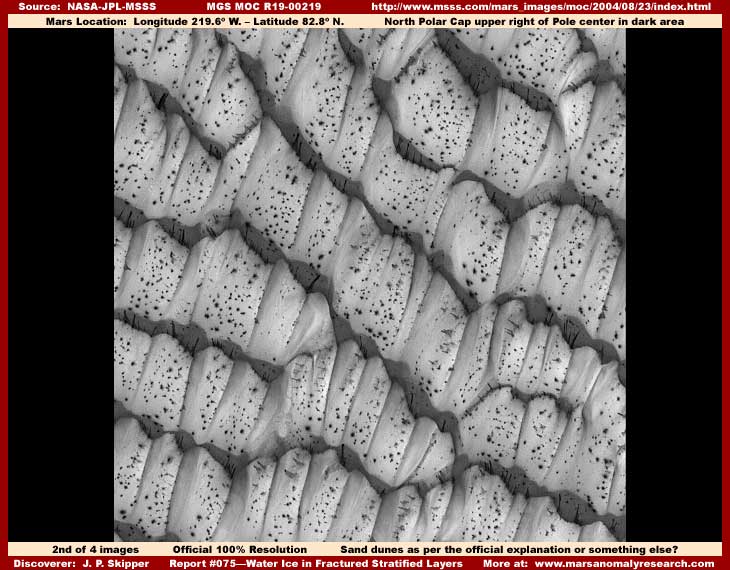
The above second image is a crop out of the official resolution R19-00219 black and white view without any work on it at all by me. Please understand that, despite its first impression and MSSS's description that the strip covers a distance of some 3 km or 1.9 miles across, this is such a distant view that a large building in a major city here on Earth would be very tiny and hard to see in this image. So, don't expect to adequately see any normal size objects down there, only these massive gigantic forms.
It is these forms that are officially identified as "sand dunes." Now in fairness please understand that, although the official text with this image specifically describes these forms seen above as sand dunes, such official descriptors are often used loosely in such captions. They often reference the general terrain area that the narrow-angle shot is sourced from. Many of the very crummy images from this general area do look a bit like dunes but then many do not as well. The imaging is just too poor to be definitive and I suspect this is by intent to obfuscate any clearer view of this area.
The official description also indicates that the sunlight is coming from the lower left in this scene. So, when you are looking at this scene only at the above official resolution, one might tend to "assume" that the dark narrow areas between and separating the "dune" forms are merely shadows thrown by the heights of the dunes into depressions between them. The official interpretation is then complete, the official Mantra is reinforced, and why would anyone look closer at just "dunes?"
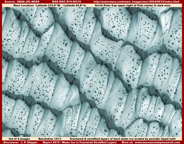
However, the above closer third image is color enhanced to provide better contrast and it shows what is really going on here and probably why this general area has been so subjected to image tampering not only in the narrow angle imaging but also in the global imaging. What you are looking at is both horizontally and vertically fractured stratified layers of surface water ice now broken up into tremendous component blocks and on a incredibly massive scale.
At some previous point in time, this was a immense, continuous, rigid, fairly level, and fairly same thickness over a broad area water ice mass as a portion of the North Polar Cap that has suddenly settled or collapsed downward, perhaps caused by a quake, undermining unstable wet ground, and/or its own weight. There is also a downward slope in the terrain in this area oriented from upper right angled down slightly to lower left.
In the collapse, the most obvious effect is that the continuous ice mass has broken up in fairly uniform stratified fracture zones from left to right forming the many slightly darker shaded vertical cliff faces. Less obvious is that the rigid ice also fractured and sheered vertical forming into many tremendous still rigid adjacent blocks. The net effect are fairly uniform steps dropping down from upper right to lower left in fracture zone step layers.
The most obvious key to understanding this is in what was initially assumed to be narrow band of shadows between the "dunes." As you can hopefully see in this better image, these are actually huge vertical cliff faces. If you will look close, you can see dark stained water flow tracks down the cliff faces no doubt formed by the seasonal beginning stages of spring water melt on and within the mass. The liquid water flow is dark stained (as is a lot of surface water on Mars) due to a dark color organism that flourishes in great colonies in liquid melt water even in this colder North Polar Region climate.
The dark color of the organism is probably an environmental adaptation to absorb the limited solar energy more efficiently and then transfer that energy as needed as heat to its immediate water ice surroundings increasing and reinforcing the seasonal melt condition so vital to its existence. This organism exists in massive quantities in both South and North Polar environments. When hard freezing conditions seasonally return, the organism goes dormant and/or dies until the next warming cycle. It dark stains seasonal drying up depressions right up to where previous high water mark lines were (and can some times be confused as water still being present) and so the dark stain continues even when liquid water is no longer as seasonally present in the depressions.
The dark color stained terrain areas then also pick up increased solar radiation in the next seasonal cycle increasing the melt in the dark stain areas making the melt in these specific areas happen earlier increasing the liquid state impact and length of the warming cycle. In other words, it is a self sustaining cycle and ecological system of life capitalizing on surface water ice liquid melt water conditions.
This organism and its dark color has a major impact in forming the dark spiral lines seen on both Polar Caps radiating out from the Polar center such as seen in the above first image. These lines are actually dark stained relatively narrow long depressions very similar to our rivers or canals. However, they are not necessarily drain systems like we are familiar with here on Earth but formed by this organism in its great multitudes creating a place for itself in the extensive Polar Cap ice mass. As this particular cycle of life repeats itself over eons, the dark stains become permanently imbedded in these depression in the ice Caps covered by the bodies of this life form and become permanent Polar Cap features.
This is obviously a cold hardy life form that takes advantage of liquid water produced by solar radiation and seasonal temperature changes on the surface of these great water ice masses and perhaps within them as well. This is not the first time that I have reported on this life form. For my previous introduction of this life form and its ecological relationship to Mars surface water ice masses, see my report #057 titled "Water Ice Masses: Ecology's of Life."
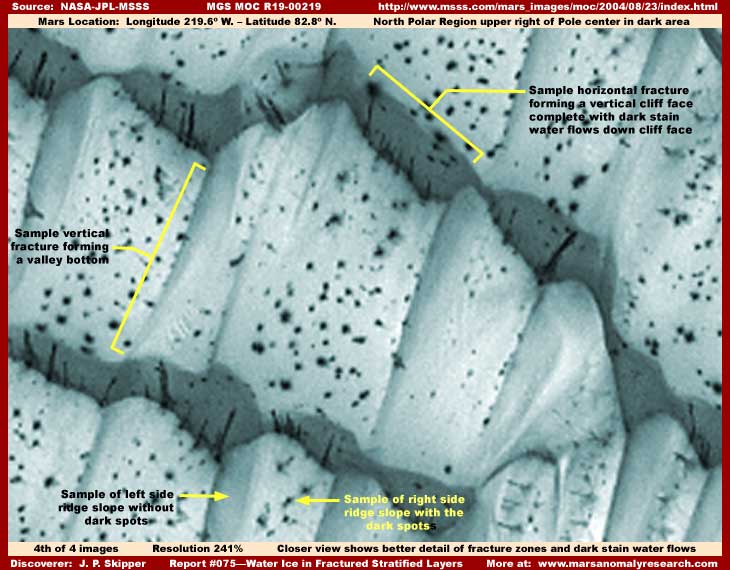
The dark shaded vertical cliff faces pointed out in the above even closer fourth image running horizontally across the scene are actually fracture zones in the what was previously a continuous massive rigid ice sheet. I suspect that the base of any one of the cliffs represents a sheering fracture zone vertical crack that extends down deep within the ice mass.
Note that dark stained water melt flows down the cliff face as dark streaks to the bottom without signs of piling up on the next step plateau below. The distance in this shot is too great to see it but the water no doubt flows into these cracks going on down further below deep within and perhaps under the overall ice mass.
It is possible that the melt water going down below may have over time contributed to erosion and undermined the originally fairly level and continuous ice sheet eventually contributing to weakness and the sudden settling collapse that in turn creates the fracture stratified layers into blocks. Water flows up from super saturated softened ground under the ice mass may contribute to this weakness as well as build the height and weight of the mass higher further contributing to its eventual collapse and fracturing into component blocks.
The dark shaded vertical cliff faces in this overall uniform pattern clearly demonstrates the stratified horizontal oriented fracture zones. The uniform overall horizontal fracture pattern and how vertically sheer each vertical cliff face is also clearly demonstrates that what we are looking at is rigid but geologically weak material constituting this mass. This is not characteristic of loose particulate sand dunes that tends to shift and flow but is characteristic of rigid frozen water ice.
Least one be inclined to speculate that these may be sand dunes suffused with hard frozen CO2 giving the mass that weak rigid quality, look more closely at the above images. Note the valleys formed on each otherwise fairly level step plateau section, all oriented down slope. Note the higher ridges formed between the valley systems. These are also vertical stress relief collapse sheer fracture zones creating tremendous blocks, just not quite as visually obvious at this image angle as the horizontal ones demonstrated by the steep cliff faces.
Note now the left side of each ridge (steeper smaller slope) is for the most part free of the dark spots while the right side (larger less steep slope form a broader sloped plateau) usually has many dark spots on its face. The location of these life form dark spots tell us that the longer slope right side of the ridges receives the most sunlight radiation and the most melt water favorable to the life form development. The valley bottoms are the vertical fracture points separating and forming the huge blocks.
As I have indicated in my #057 report, the dark spots represent life forms that flourish in melt water. Although the distance as usual is too great to visually see it, the presence of the dark spots and the life forms they represent signal us that melt water is present on the upper right slope slanted surfaces of these huge ice blocks. Melt water flow is further confirmed by the very dark weep flow signs down the steep slope of the horizontal fracture zone cliff faces. Note that some flows originate at or near the top but others also originate from points well down the slope apparently coming from the interior of the blocks.
I make this point about the evidence of liquid flows because a liquid state is not a characteristic of CO2. The official Mantra is that these Mars Polar ice Caps are made up primarily of frozen CO2, not water ice. This is based on officially released instrument temperature readings as low as –185+º F. in for example the South Polar Region and the average temperature in the North Polar Region where the evidence in this report comes from is generally even colder. If true, such extreme cold temperatures mean that CO2 gas can freeze out of the air and fall to the ground as CO2 solid snow particulate and form ice there. Further, any water ice melting to a liquid state in such super hard freezing conditions would be impossible. It is the basic data upon which the official theories and computer modeling are based.
However, my liquid surface water discoveries, the main ones of which I've been holding back for inclusion in my book, demonstrate that there are many depressions around the planet surface containing liquid of some kind, including many in the South Polar Region with some being right on the Cap itself. Water ice masses are even more plentiful. So someone is wrong and I don't think it is going to wind up eventually being me since my position is supported by their own official visual science data evidence.
At the bases of official theory powering the prevalent computer modeling these days is the extremely cold instrument temperature readings. It simply limits and precludes any other considerations. However, I suspect it is either inaccurate or completely fake. Why? Because of the presence of my liquid discoveries in depressions around the planet including in the South Polar Region right where the instrument temperature reading was taken, not withstanding some lame official explanations that these are dark sand settling in depression areas even though bottom land forms can clearly be seen through and under the "sand."
You see, CO2 does not normally have a liquid state and especially in open terrain where expansion is possible. Be aware that atmospheric CO2 converts directly from a gas state (vapor) to a solid state (snow/ice) in the presence of sufficient freezing temperature and converts back from a solid state directly to a gas state in the presence of sufficient warming conditions. Atmospheric pressure and other factors can change this a bit but not nearly enough to be a factor here in these considerations.
Dry ice is frozen CO2 in solid form. In the presence of sufficient warming temperature, dry ice will boil off as a gas/vapor and never achieves a intermediate liquid state as does water ice. This can be demonstrated via simple observation by anyone with access to commercial dry ice. CO2 severely compressed under very high pressure in confining plumbing systems can achieve a liquid state but not in open environs where expansion is possible. This is an inescapable fact. The bottom line is that, if one sees a liquid in open environs such as in the Mars surface terrain, it cannot be CO2 and all of the other elements other than water vapor in the atmosphere require even greater cold freezing temperature extremes that are not present on Mars.
This leaves only H2O water in vapor/gas, liquid and solid snow/ice states as the most logical answer. If so, this places the official temperature readings in serious jeopardy and in turn the accuracy of the scientific computer modeling and conclusions along with it. You will eventually see that it will be this reality that will prevail.
I suspect that is has been this fracture and sheering effect forming these many cracks, sheer cliff faces, and stratified block levels along with the water flow evidence in this particular Mars terrain that they have been trying to obfuscate on these Polar Caps images. While the great swirl patterns evidence on the Polar Caps may be a mystery and less interpretable to most geologists and the very poor imaging looking somewhat like "dunes" reinforces this perception, the rigid collapsed blocks and water flow evidence seen here would be a serious tip off and interpretable by at least some professional geologists leading in a direction counter to the official Mantra that Mars is a very dry dead world with little or no surface liquid water or water ice that can in turn support life.
So, is this R19-00219 image a mistake or slip up? Is it intentional? Could it be a test of the science community's interpretive ability or a tentative nudge in the direction of eventual acceptance that Mars may have substantial water after all as the secrecy insiders try to turn aside a little from the past total secrecy blanket?
I have no conclusive answer for such questions. All I can say is here is the evidence of water and in a huge quantity on the Mars North Polar Cap both in solid and liquid flow forms. The real question now is whether or not the science and academic communities (and the public they are suppose to serve) are all so far sunk into past decades of effective secrecy conditioning that they cannot now be objective enough to recognize water evidence right in front of them on their own without NASA or JPL giving them a stamp of approval?
DOCUMENTATION
http://www.msss.com/moc_gallery/r03_r09/mc01.html: This link access the global view of the North Polar Region and Cap that I've used in my first image in this report. I merely used it for convenience because it has few green markers on it to deal with when I developed my graphic outlines. This global image of the North Pole does not contain the MOC2-827/R19-00219 image marker, so don't get confused about that and try to look for it there.
http://www.msss.com/mars_images/moc/2004/08/23/l: This link accesses the captioned image labeled MOC2-827 image in that MSSS captioned release but is really the MOC R19-00219 image once that science data image set is released. For now use this URL as I have done. In the future, when the next science data image set is released, look for the R19-00219 image there.
, Investigator
![]()