
MARS WATER ICE MASSES
ECOLOGY'S OF LIFE
Report #057
December 26, 2003
Good cheer and good health to you all on this holiday. As I post this, the ESA (European Space Agency) Mars Express spacecraft with its primary orbiting radar imaging capability of the planet's surface and its lander (not a rover) Beagle 2's "mole" able to dig down some into the Martian subsurface soil of Isidis Planitia (a plain) a few feet out from the stationary lander has just made its rendezvous with the red planet. Hope everything continues to go well. It's quite an achievement for ESA on such a limited budget.
Also, two USA lander/rovers are close on its heels. There is Spirit arriving in a few days on 1/4/04 and Opportunity arriving later on 1/25/04. Each has an identical rover but landing and testing in different regions, one being Meridiani Planum (a plain) and the other Gusev Crater. Each ground rover will have a camera at ready for close surface level imaging as they travel around and their RAT (Rock Abrasion Tool) instrument systems for analyzing surface rocks.
While there may be more to these missions than publicized, their primary publicly stated goals are to determine if there is water or water ice resources present on the surface and up to 3 miles deep (via radar) in the planet's surface and the possibility of life organisms past or present in the Martian soil. I suspect these efforts, at least at for public consumption, are all likely designed to serve as the medium by which to begin to release a little incremental information to begin preparing the public for the presence of water and some life on Mars that they already well know is there but not yet in the magnitude they also know is there.
I suspect this is being done because scientist, having swallowed previous secrecy agenda misdirection manipulations hook, line and sinker, with their unfortunate deep rooted paradigm mind set, have been unable to recognize any of the surface water evidence intentionally sprinkled around in the previously released MOC satellite imaging data. This may mean that the secrecy agenda is now having to come forward with more obvious and "approved" incremental evidence where they take the lead in the identification process to overcome this perceptual problem of the general scientific community. Once a direction has this official leadership stamp of approval, I think we can all anticipate that the science and academic communities will in general dutifully follow incrementally in this now clearly approved direction.
I also suspect that the growing independent discovery evidence record you see posted here at this website combined with the liquid surface water evidence that I have not yet released, but which they well know that I have, has since its inception in midyear 2000 had something to do with pushing this particular alternative agenda's timetable forward. It is one of the reasons that I held this information back to encourage this psychology and try to influence their agenda is this regard. If you have read my commentary piece titled "Is Anyone Taking This Seriously?," you may better appreciate what I'm talking about here.
This particular report, although still very mild and limited in its content relative to what they don't want you to know as yet, reveals a little of what they have already long known and now you will know it to. At the same time as throwing us a bone with this coming water ice information and possibly some minor organism life evidence information, the secrecy agenda doesn't want you to contemplate, at least not yet, the full scope of the truth about surface water and thereby life on our sister planet and especially this kind of information's full implications.
I suspect their idea is to creep up on this in small increments and in the process buy years of time. Their timetable of probes to Mars over the next few years speaks clearly of their intent. First, we have the current 12/2003 and 1/2004 probes and the release of their primarily instrument data revelations as opposed to visual information. I expect these to confirm water ice (via ESA's radar imaging) but not liquid surface water yet and perhaps some minor organism life suggestive evidence. Hard frozen water and minor organism life past or present evidence will not significantly impact the current secrecy agenda as long a revelations do not go beyond that. I suspect this limited information will be designed to throw us a bone and at least begin a paradigm shift in the science and academic communities and widen their thinking patterns as to what may be possible on Mars after all.
Then there will be the MRO (Mars Reconnaissance Orbiter) set for launch in 2005 with very high resolution visual imaging (publicly acknowledged down to 3.3-feet or 1-meter resolution) capability. If its information flow isn't stopped, next level highly suggestive revelations will come from this probe that will begin the serious eye opening process for any portion of the science and academic communities that are by that time still stuck too much in the old paradigm mindset.
However, as important as bringing this brain power resource on board is, I suspect the 2005 MRO's real primary mission will be to outright secretly map and probe in detail facilities around the planet both above ground and below ground for military intelligence purposes. If our technology can be effective against such targets and not be defeated or manipulated from Mars level, anticipate that this will be a high risk secret military mission with countermeasure failure a distinct possibility. If that happens, too bad, but it will still create delay and buy time for the secrecy agenda and so it will be a win situation for them either way, although not for tax payers.
Then in 2007 the Phoenix Scout mission is scheduled. The information on this probe currently available indicates that it is suppose to be an updated version of the old MPL (Mars Polar Lander) mission that in 12/1999 was in the process of making a soft landing on Mars at the edge of South Polar Cap and was supposedly never heard from again. Also attached to that lander were a pair of small tough independent probes that were suppose to be deployed at high altitude to fall, impact and penetrate beneath the Mars surface and call home with their data and they were also never heard from.
To give you an idea of what may have really been going on with that probe beyond its publicly stated goals, its alleged failure was investigated by the usual key players NASA, JPL, MSSS and others on the one side saying that a malfunction caused the craft to plunge onto the planet's surface destroying it. But, then also NASA had to "invite" in the super secret spy agency then named NIMA (National Imagery & Mapping Agency) and now renamed the National Geospatial-Intelligence Agency, who conducted their own search via MOC imaging data for the lander on the Mars surface and reported that they may have found it and suggesting that it might even be intact. JPL working through MSSS disagreed and stated that the NIMA spy satellite imaging experts (the best available in the world) got it wrong and mistook camera noise for glint reflections.
Sounds like stonewalling to me and I suspect it privately did to NIMA as well. I doubt that the Phoenix mission for 2007 is really just a renewed version of the 1999 Mars Polar Lander publicly stated goals using better technology. I suspect that the MPL mission was not a real failure but its data hijacked by one side in this internal tug of war based on opinions as to who needs to know and who is best suited to control this information. I suspect that the 2007 Phoenix mission is a reschedule of the not publicly stated military intelligence goals that NASA and JPL had to agree to following the MPL investigation but now of course using more advanced technology. Further, I suspect that the 2005 MRO is the same thing and the 2007 Phoenix mission is a backup to that in case the secret MRO technology is defeated or subverted or if there is another unfortunate complete mission failure.
I could go on and on into this as it is one of the things that initially drew me into this Mars anomaly research but must cut it off here or this report will reach pathetically large novel length proportions and never load up in your browser. However, one final comment. How would you like to immerse yourself in this nasty covert subterfuge world of secrecy and misdirection on top of misdirection where up is down and down is up, nothing is ever as it seems, and constant compromise is the name of the game?
BACK TO THIS EVIDENCE
My above first image at the top of this report is striking and sort of pretty isn't it. This type of evidence and reporting on these water ice masses and the ecology's they generate is subject matter that will also be appearing in my coming book.
Since I anticipate that water ICE will be information having secrecy agenda approval for official release by the current crop of Mars probes and many of you will be seeing this in the months ahead coming from official sources, I thought I had better release some of my own information on this now that I've been holding back before they get a partial jump on me credit wise. Yes, I've got an ego to. At least I sweeten the pot more because my information here will cover what little they may report but also go well beyond anything that you will be exposed to as yet from official sources.
In getting ready for the new 2004 year, this report is all about the many water ice masses on the surface of the red planet, the liquid melt surface water they generate, the opportunistic biological life taking advantage of them, true Mars surface temperatures, and questions about the highly anomalous terrain these huge objects sit in like islands in a sea of "something." Here again I'm getting ambitious and trying to convey in this shorter (relative to the subject matter) reporting style with only five images a lot of information on a very complex multifaceted subject that would normally require literally many volumes of analysis and imaging.
Even though this report is longer commentary wise than many of my reports, it certainly doesn't pretend to cover everything or answer all possible questions relating to this subject. This limitation is partially a function of the report's brevity relative to the subject matter where some information must be excluded or at least passed over too lightly.
My goal here is to provide some initial basic exposure and insight on Mars water ice masses, that they are associated with surface liquid melt water, the more obvious biological life that tries to capitalize on them, an eye opening shot across the official bow on some nearly sacrosanct but questionable official atmospheric temperature data issues, and to draw attention to the highly anomalous terrain these huge water ice masses sit in.
However, before getting to all the evidence, there are a few preliminary issues that you need to be aware of that are pertinent to a broader understanding of this evidence as follows.
DARK SPOT DEBATE
You should be aware that the so called Mars Dark Spots, such as those seen here in my imaging, is an issue of debate and differences of opinion among the world wide community of scientists. It is a mystery that no one seems to be able to resolve to everyone else's satisfaction scientifically speaking but then there's nothing unusual about that now is there.
There seems to be essentially a group of credible European planetary scientists coming to the conclusion that these spots possibly represent Martian surface life organisms of some kind similar to what might be seen in the Earth polar regions. On the other hand, there are well qualified USA based scientists involved with official NASA/JPL Mars exploration saying an emphatic no to the concept of life and instead promoting geological explanations. I suspect that the official position here in the USA is anticipated and does not surprise many viewers familiar with the evidence presented here at this website.
The scientific report that started this controversy was first made by a group of Hungarian scientist and I think you need to first take a look at their paper on this subject found HERE. Note that it is a PDF file with slow loading images on a dial-up connection, so be patient. The USA official position refuting this organism life concept is best represented by the comments of Dr. Titus, a USGS scientist associated with USA based Mars exploration, found HERE. Apparently insufficiently convinced that it should completely ignore this evidence as possibly representing life, the European Space Agency (ESA) still expresses an interest in the life concept as per their comments found HERE at their website.
Take a look at all these differing sides and you will begin to understand that this is a significant issue in the space science and academic communities that isn't quite going away but remains hung up in a perceived indeterminate status. Keep in mind to that such a indeterminate state is just fine with the secrecy agenda and serves their purposes.
TEMPERATURE ISSUES
If you've examined the material at the above links, you will see that basically there are scientists looking at the evidence and drawing conclusions based on their analysis of that evidence and publishing it. On the other hand, the refutation of their conclusions seems to be based primarily on probe instrument science data readings that Mars is far too cold at as low as -195º F. (-126º C), at least in the South Polar Region, to support water in a state that might in turn support life and that what may look like water ice or snow is actually Carbon Dioxide (CO2) ice or snow, which of course would be far too hostile an environment for known organism life to flourish in even temporarily.
Although not specifically stated, the core of this differing of opinions is based on just how cold the true Mars atmospheric temperature is at surface level? The NASA and JPL official position here as articulated by Dr. Titus in the USA in his refutation arguments of temperatures as low as -195º F. (126º C.) is based on well accepted hard science temperature instrument data obtained from the Mars surface in previous older probes.
Such an extreme temperature would be more than sufficiently cold enough to freeze CO2 out of the atmosphere to fall to the ground as CO2 solid particulate snow or ice. Since this temperature data is considered established fact by many mainstream scientists like Dr. Titus so loyal to the USA based official position, how can one argue with that?
NATIONAL SECURITY
Missing from both of these sides and their consideration is that they do not sufficiently contemplate the possibility that such hard science data may have been filtered through and subverted by secrecy agendas operating under the National Security umbrella within the controlling USA space exploration entities and may be information not necessarily representing complete truth. For mainstream scientists and academics like Dr. Titus deeply and unquestioningly committed to the official science data being accurate just as presented to their community, any questions to the contrary are considered completely preposterous and immediately excluded from consideration.
Unfortunately, absolutely no one in these closed loop mind sets will publicly consider that, if advanced intelligent life did exist on Mars, they might be able to manipulate our technology around and on their planet to produce just such data returned to us. Such a concept is just too fantastic to consider because after all we know absolutely that ........................., well it just can't be, that's all!
So what is the truth? For me the truth lies in observation of hard visual satellite imaging evidence that I can analyze and not based on data claims someone else asks me to trust and accept on faith because of the long term reputation and credibility of the source or because some have "feelings" that any other explanation is just too fantastic to consider. As many of you have read in my reports, in my research into the visual science data, I see many reasons not to blindly trust all of the official data, and that is what it boils down to, TRUST! Perhaps its the long years as an investigator but I trust only what I can verify for myself.
Why not just trust on faith? For one thing, there is way too much blind following in evidence in space exploration in general and more specifically too much reliance on computer modeling that carries with it the illusion of science but is really no better than the quality of data that it is fed. There is just too much questionable data being fed into these computer models that they think is completely sound.
Also, I am reminded of that competent Navy Admiral military intelligence super spook also of NSA fame chairing the JPL oversight committee and therefore Mars exploration not out in the open but in SECRET until he was ousted by a powerful insider in a internal power play. I am also reminded of the attempt not to release the MGS MOC data in a timely manner as legally required until growing public pressure (I was a small part of it) to do so had its impact. I am also reminded of all the massive amount of image tampering I have been reporting on in the satellite data, etc., etc. Well you get the picture.
WHO'S RIGHT?
I have many liquid surface water discoveries that I have been holding back to present in my book (coming) that are quite impossible according to the USA based official position on Mars atmospheric temperatures as are the ones I've already reported on. Further, many of them are in the South Polar Region right where the most intense freezing temperature instrument readings are suppose to have been taken. So I'm sure you can imagine what such hard observational visual evidence tells me about the true temperatures in that region and the sacrosanct -195º F. hard science data.
I expect some like Dr. Titus will be seriously put out when my liquid surface water discoveries I've been holding back are released and those like him so loyal to the party line will no doubt be trotted out on the offensive and attack. It will no doubt have to be on a personal level since they obviously can't very successfully attack their own science data from which these same independent anomalous discoveries are drawn. That direction would be, shall we say, inconvenient.
The fact is that, from the satellite imaging evidence that I've collected of many liquid surface water discoveries on Mars, I have no choice but to conclude that the official position on Mars surface temperature extremes is very much incorrect and just does not represent truth. But, although you will see that hard science data liquid surface water evidence released here and in the book, it isn't quite here in evidence yet. So, in the meantime, is there any other satellite imaging science data evidence that may point to atmospheric temperatures milder than officially promoted and along the same lines that all these probes are going to Mars for?
As a matter of fact, besides the liquid surface water discoveries I've already reported on along and along, there is other liquid state water evidence associated with surface water ice masses and that is one of the main reasons for this report. Further, it just so happens that examination of this water ice mass evidence also impacts the dark spots subject matter and the debate over that in the scientific community as well as true Mars surface temperatures.
SURFACE WATER ICE
The first basic concept we need to keep in mind is that, if there is water ice at all on the surface of Mars, it is still water and, even in solid form, it is still a resource that life can utilize using the appropriate adaptation. In this regard, the newest official position as expressed through the more recent Odyssey probe THEMIS (Thermal Emission Imaging System) data is that water ice exists underlying the surface is a concept moving toward being increasingly publicly acceptable to consider on Mars. I expect the ESA Mars Express radar imaging to conveniently confirm this as the incremental step agenda is developed forward for public consumption.
But, of course, I expect this incremental revelation definitely will not yet extend to larger bodies of liquid surface water. This is because water ice, especially deeper down water ice, as opposed to water on the surface in a liquid state, alone as a subject does not necessarily undermine long promoted previous official positioning and data that Mars is this incredibly cold hard frozen world where no surface water in a liquid state is possible unless heated by geothermal sources and thereby temporary in existence.
Bodies of liquid water on the surface is a subject to be avoided because its recognition would place previous official heavy positioning and data that Mars is a frozen dry dead world in too much sudden jeopardy. Obviously, if wide spread liquid surface water not necessarily influenced by some geothermal hot spot, was suddenly recognized and accepted, the willingness to consider much milder environmental conditions and that biological and even civilized life may be possible and proliferate on the planet in such milder conditions would follow right on its heels. In other words, one thing is inextricably tied to the other in a domino effect making even surface a touchy subject. Preventing that direction of thought, at least for the time being, is core behind all the investment in secrecy agenda designed to delay full awareness of the true Mars reality.
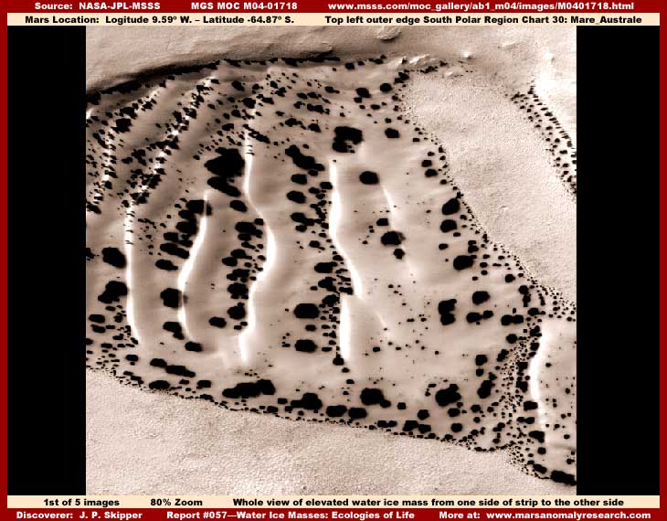
So let's start at the beginning and ask some first questions such as is there at least water ice on the surface of Mars and, if so, was this already known long before the Odyssey and the newer more current probes were launched? In the first image above at the top of this report from strip M04-01718 you see a visually dramatic looking dark spotted water ice mass as seen extending from one side edge of the original strip to the other.
This is just a representative sample of many such water ice masses. This one has been chosen primarily for its image clarity. These ice masses exist in the many hundreds and perhaps thousands in the MGS MOC imaging. Don't worry, just be patient, as you read this report and view more evidence, it will become increasingly clear that this is in fact an ice mass made up of water rather than some other compound like CO2.
In the above first image, it looks both strange and strikingly beautiful at the same time doesn't it. Considering that it has such visually high drama looks and very often easier to see gigantic sizing, how is it that so many official level scientists going through this evidence data could have missed proper identification of these masses in the MGS MOC imaging data? I to find it strange how they could have possibly missed it or its implications and that includes the European scientists with their dark spot theories to.
I repeat, these types of water ice masses looking very much like this are no real rarity. They are especially numerous in the South Polar Region. They are often found in the bottom of many craters but also in many other low level depression areas around the planet right where one might expect to see such water evidence. There are noticeable differences between them. Ices masses in more open exposed terrain most often have the spots you see here while those tightly confined deep down within protecting crater or pit walls often have fewer to no spots. Likewise there are also other ice masses that have a dark coloration over their entire body but that is a different subject that will have to wait for another time due to the space limitations here.
Here on Earth where surface water via rainfall or snow particulate on land accumulates in topography depression catches and drain systems as the primary initial fresh water source. However, on Mars surface water presence, whether a ice mass or liquid body, is primarily a function of flows from underground to the surface. So, the most likely scenario is that ice masses like the one you see here in my first two images are formed by water pushing up from underground and spreading out on the surface flooding the nearby terrain and freezing there. Some of the really big ice masses have probably been formed in a period in antiquity when freezing temperature were more pronounced and the masses may have once been much larger and more expansive than they are today.
In forming these ice masses in more recent geological times, the liquid water often continues to flow from below under the hardened surface cap of ice building and increasing the overall size of the core ice mass area from the underside up gradually elevating the central core area of it higher and higher in the surrounding terrain into what often eventually becomes a visually striking elevated huge massive mount that towers over everything else in the terrain it sits in. This is precisely what you see here best represented in my above first image at the top of this report. It is a fairly average size mass as they go and, as big and massive as it is in absolute terms, it is by no means the largest.
The ice mass increasing in size and elevation depends on the degree of water flow from below under it and the open air temperature conditions in the area. Some of the older masses can be identified by the dirty appearance of the mass as the years, centuries and eons go by and its damp wetted surface attracts passing wind blown dry sediment adhering to its damp body. Some of the oldest surface mass remnants with very high sediment content cover entire regions and visually look more like geological rocky terrain than the old heavy with sediment water ice mass remnants they really are. The clue to recognizing them for what they are is in how different their surface has eroded over a long period of time as compared with true rock on Mars or the younger more pure ice masses.
When this scenario is playing itself out in the visual evidence, the official position will often be that the eroded surface is geological rock that has been eroded by wind blown sediment over long periods of time, which of course continues to promote the dry dead world theme. In some cases this may be true but in others we are often actually looking at hardened sediment heavy ice that wind blown sediment as well as melt water flows has eroded over a broad area that does not necessarily produce gully system because of the hardness of the old ice/sediment mix. But, that to is a related but different story and will have to wait for another time due to space limitations here.
Some ice masses are smaller and some younger while others are as large as entire mountain ranges and very old. Don't let the look of the water ice mass in the first two images depicted here fool you as to size! The ice masses imaged here is a relatively newer one fairly clean of sediment content but, although it is smaller to medium size in relative terms to some others, it is still huge in absolute terms from our perspective and far larger than it looks in this imaging due to the very distant resolution provided but not admitted to and the lack of any familiar comparison visual frames of reference in these scenes.
For example, the ice mass in the first image you see above may be of a size comparable to small to medium size city in its across diameter measure. I cannot give you a more exact measure simply because I do not trust the official statistics provided to be accurate in all cases. If you have been reading any of my other reports and viewing the evidence provided on image tampering, you will understand why I question this data. Frankly, a great deal of this imaging released to the public is of a much more distant view than officially defined because that distant view with its poorer resolution does much to obscure the image tampering applications and researcher's ability to properly recognize them.
In my first image above, also note how sharply defined the ice mass depicted is from the completely different looking terrain it sits in. This is a especially important observation. Note the grainy lumpy but fairly uniform and level texture of that terrain, so entirely different than the ice mass surface itself. Just ignore the light color of the terrain as color can easily be digitally manipulated in specified areas and I suspect that has been done in this and many other strips.
On the ice mass itself, note the very smooth parallel "waves" look on the center top surface area and of course the very dramatic looking and solid appearing dark spots of differing sizes contrasting so sharply with the water ice mass light reflective high albedo color. Note to how these dark spots on this particular ice mass are thickest to the left of each of the wave look elevated ridge lines on down into the lower level troughs as opposed to the right side. Note that this is also the side the solar radiation is greatest on as clearly indicated by the more intense sun light reflectivity on that side. Note that the slope down from each ridge line is longer and more gradual on the right side but shorter and more steep on the left side where the sunlight is striking it.
Now note in the first image how the dark spots are very plentiful near the outer perimeter edges of the ice mass where it meets the surrounding terrain but not much more plentiful there as compared with their collection within the troughs in other inner areas of the ice mass. Note how many smaller spots cluster thickly at the top of the ridges in the upper left corner of the mass in the above first image. Finally note how very smooth textured the ice mass surface is as compared to the uniform rougher texture terrain it sits in. All this visual observational evidence is important in the interpretation of what is going on here and also very typical of the general appearance of these water ice masses.
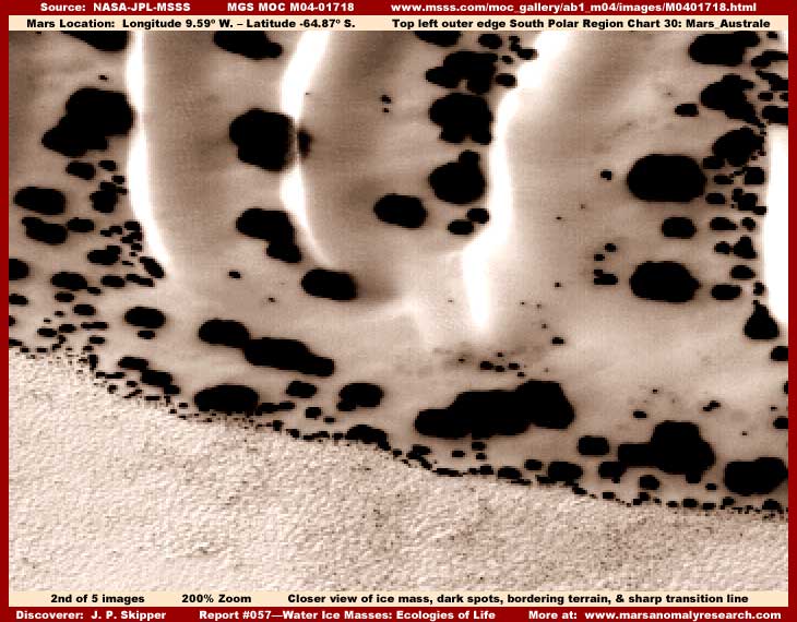
Now the above second image from the same M04-01718 strip provides a closer view of a portion of the same ice mass and the terrain it sits in. This mass's extremely smooth contoured surface is an excellent and telling indicator of water ice subject to melt conditions. The tops of the ice ridges are more representative of an earlier height of the ice mass at some point in the past and the troughs represent how this original height is being worn down in these areas.
Prevalent solar radiation (sun light) strikes in this case the left side of the ice ridges more than the right at certain times of the day and year causing melt water to run down the left side of each ridge more than the right into the troughs between the ridges. That is why you'll note that the left slope down from the ridge tops represents a sharper slope incline as opposed to the more gradual right slope from any one ridge line because of the heavier solar radiation melt erosion flow on the left side. As will become increasingly clear, the dark spots represent organism life of some kind taking advantage of this liquid flowing melt water content of the mass.
Broadly speaking, the liquid or semi-liquid melt slush water runs down the entire mount's grade from the higher level center areas toward the lower level outside perimeter edge areas. This slow creeping flow causes the erosion of broad trough flow channels in the center area between and defining the water ice ridge tops. The liquid then spreads out onto the broad flattened outer edge area with a portion freezing there as well as a portion also flowing over the edge into the surrounding terrain.
That is why the outside edge areas of the ice mass have a lower profile flattened look without ridges in comparison to the center more elevated area of the mass because it is all created by water in a more liquid or semi-liquid self leveling state. Likewise, the extremely smooth surface over the whole mass is created by the self leveling process of minor melt that more quickly freezes back in place very typical of water ice in the flux of periodic minor melt and freeze conditions.
Also, in the above closer view second image, for the moment, please take special careful note of the nature of the lumpy but uniformly textured surface of the terrain immediately adjacent to the ice mass at the bottom of the image and how dramatically different this is in texture relative to the very smooth texture of the ice mass surface. Note to how sharp the demarcation line is separating the ice mass from this terrain it sits in. Note how this terrain at the demarcation line at and just back from where it butts up against and overlaps the ice mass appears to be showing evidence of tiny geometric forms. Ignore the color of the terrain as it probably has been artificially manipulated. This is very typical observational evidence associated with a great many of these types of ice masses.
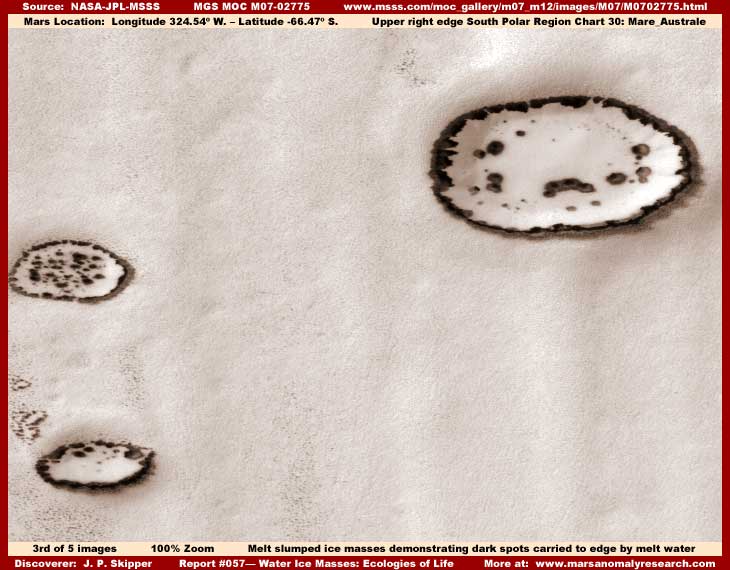
Now, in the third image above from a different M07-02774 strip, you see this representative sample of ice masses in a different area but in the same type of carpeting rougher texture relatively level terrain, just a little more distantly seen giving the terrain surface a finer grain appearance. These water ice masses in the above third image have clearly been subjected to stronger melt conditions than the evidence in my first two images from the M04-01718 strip. This increased melt flow factor has caused each of these masses in their entirety to be more rounded, slumped, flattened and lower profile with a lower center area and broader slumped flattened leveled outer edge areas.
Also, very important, please note that the melt flow from the former higher center elevation area has been strong enough here to carry many of the dark spots downhill from the disappearing center areas thinning them out there to the much lower level edge areas where they have densely collected creating a concentrated continuous dark ragged collar or ring around the water ice mass perimeter edges. All of this is significant observational evidence.
It demonstrates, very important, that these masses are subject to converting at least partially from a solid state to a liquid flowing state on their surfaces. It also demonstrates, very important, that the dark spots being carried to a different lower level location by melt surface water flows means that they are associated primarily with the upper or outer surface levels of the ice mass and do not originate from and are not rooted deep within the mass itself. That observation will put a real cramp in any potential argument that these spots are merely a natural geological chemical reaction of some kind percolating up to the top surface from deep within the mass.
Additionally, look very closely and note the separate narrow band of dark staining on the lower right of these masses for a short distance out in the terrain just beyond the outer edge demarcation line of the water ice mass dark ragged collar in my above third image. This could be an indicator of very wet saturation conditions in a narrow band in the immediate surrounding terrain just beyond the ice mass demarcation line edge confirming the stronger liquid flow off of the ice mass. However, since it is confined to basically the same side of each of the larger ice masses and appears to coincide with perimeter irregularities in the dark collar area, it is more likely a short shadow cast into the adjacent terrain by the low profile outer perimeter dark collar edge of the water ice mass simply because the center area has now melted so much that it is actually slightly lower than the outer edge area.
This evidence is very characteristic of water ice converting at least partially and temporarily to a liquid state and flowing down off the elevated ice mass and into the surrounding lower level terrain and carrying the dark staining spots with it. This process can continue until the ice mass bulk is significantly depleted.
TEMPERATURES & CO2
At the same time, it should be noted at this point that this is in turn not characteristic of and undermines any argument that the ice mass is made up of any other compound such as the well promoted official stance favoring CO2 as that compound. As many of you may know, CO2 snow or ice has been historically and officially heavily pushed as the explanation for what most of this light color highly reflective ice is on Mars, including constituting the great bulk of the Polar Caps themselves. Further, remember that the official science probe instrument data confirms that temperatures in the South Polar Region have been measured as low as –195º F. as indicated by Dr. Titus in his arguments. Now you have to admit, that's seriously cold!
But, is it really true? We know that H2O (water) at sea level here on Earth starts freezing at a mere 32º F. (note no minus sign) and likewise CO2 freezes at around –109º F. Different atmospheric pressure, gas saturation, and other variables on Mars will alter those points to some degree but not nearly enough to make up the substantial temperature conversion point gap difference between the two compounds necessary to support the CO2 theory.
Additionally, while water can change from a gas, to a liquid, to a solid, and then back through the reverse order, the same is not normally true with CO2. It simply does not even have a natural "liquid" sublimation transition state as does water and that is especially true in open environs where expansion is possible and pressure extremes (such as refrigerant compression within plumbing systems) that might form CO2 liquid are just not feasible or present in sufficient amounts to accomplish this in open environs.
If any of you have ever had any direct experience with a block of CO2 (dry ice) where the surrounding temperature is higher than the dry ice block's temperature, then all you've seen is the block disappear as it turns directly from a solid to a gas state with no liquid transition state at all. All you will see at most is a little fog or vapor floating in the air off of a block of CO2 ice.
So, basically, if we see any viable evidence of some compound being in a liquid state on Mars in open surface environs where expansion is possible, the simple fact is that it just can't be CO2 and is logically far more likely to be water. This is an over simplification for the sake of brevity here but is a fact that stills holds true under rigorous examination.
Further, clearly the kind of very heavy melt liquid state evidence seen here, especially in the third image, cannot be exclusively explained by solar impact radiation alone, even with the dark spots absorbing more solar energy, releasing it as heat, and adding to the melt. Obviously, this logically must also be assisted by at least at times milder general temperature conditions more favorable to this universal degree of stronger water melt as clearly demonstrated in the above third image.
Remember, this melt water liquid flow evidence shown here is all in the South Polar Region where it is supposed to be as much as –195º F. So, if milder than promoted environmental temperature conditions are true in the colder South Polar Region, what does that say about temperatures at or near the equator where the planet offers its broadest exposure to the Sun and temperatures can be expected to be much warmer?
The logical extrapolation is that the kind of liquid state water flow evidence seen here with these ice masses undermines the official position on the true general temperature conditions on Mars. Since CO2 has no practical conversion liquid state in open environs where expansion is possible and the –195º F. reported official temperature data Dr. Titus reminds us of is no where near cold enough to freeze other elements like Nitrogen out of the atmosphere and yet we are seeing this liquid flow evidence right in the science data just as you see in my imaging here, then that logically leaves water as the only choice. Further, in the liquid surface water that I will soon be releasing via my book, it also just simply behaves like water and is found in depressions exactly where you would expect to find water.
In fact, for comparison purposes, I intentionally extracted the evidence here in this report directly from the South Polar Region right where it is officially suppose to be so incredibly cold enough at –195º F. to freeze CO2 out of the atmosphere. If that super cold probe data instrument reading was really accurate, then the melt liquid flow conditions you see here would be quite impossible as the temperature would be far far beyond anything needed to freeze water and prevent the existence of any such liquid water flow evidence. Remember to that CO2 has no liquid state in such an environment where expansion is possible.
So the liquid state melt water flow evidence you see here associated with the water ice masses speaks for itself and tells a very telling story. This logical analysis is similar in basic form to how the Hungarian scientists approached coming to their conclusions on the dark spots. They simply extrapolated directly from the hard observational evidence at hand rather than deciding up front that the evidence as seen was impossible and paying it no further attention as our USA official positioning would have us all do. Unfortunately, they just overlooked the fact that visual supportable proof of liquid state water flows that would in turn support their life concept was available in the official science data just as I have shown here.
You will eventually be seeing much more general surface water supportive evidence in my coming book and here at the website as reports like this ice mass melt water prepare the way for it. You should also know that the evidence presented here is representative of a great deal of evidence that I've seen and what you see here is only a representative sample of it. Likewise, when all the liquid surface water evidence I've been holding back is released in the book plus even more of it here at the website, such official positioning as to extreme cold –195º F. temperatures and CO2 will again be in even more serious trouble with all that quite impossible bodies of liquid surface water hard visual evidence and its temperature implications to deal with.
DARK SPOTS
But, water ice and its liquid state melt water flow evidence alone, as ultra important as it is, isn't the only story here. Now let's get to the dark spots themselves and what role they play. I'm sure my explanations for the spots will be considered equally as preposterous or more so and offensive to most mainstream scientists deeply entrenched in and committed to their paradigm preconceived beliefs as to the accuracy of the Mars atmospheric temperatures readings.
The Euro scientists are on the right track in suspecting this as organism activity evidence but my call on this is going to differ and go well beyond their theories. Frankly, I had become so used to the scientific community's paradigm blindness, that I was caught off guard a bit and surprised when these scientists actually picked up on this at all. If I had anticipated this, I would have revealed the information first myself.
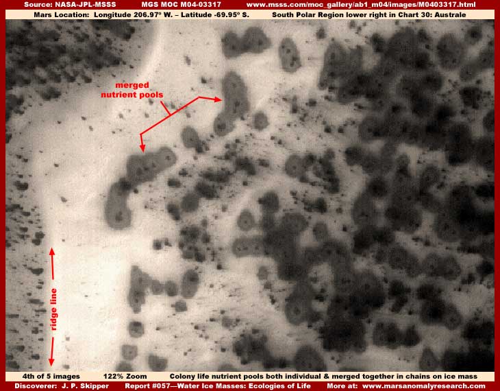
In the fourth image above drawn from yet another different strip M04-03317 representative of this type of evidence, note especially the representative sample dark spot areas pointed out by the red arrows on top of this much larger and broader ice mass. Take careful note of the above dark tinted but transparent spots with an even darker smaller spot in their center at their bottom and then compare them with the much darker more solid appearing spots in my first three images here with no such visible transparent quality or small center darker spot.
All these are the same thing, just seen in different stages of their development cycle. The semi-dark transparent stain spots above are, very important, the earlier developmental stages of the very dark more solid appearing spots seen in the first two images in this report. The light color area running north and south in my above image to the left of these dark tinted stains is another of these melt water eroded ice ridge lines pointed out with red arrows. The dark stains are down in a wide trough below the level of this elevated ridge line.
Note how clear and uniformly dark tinted the spots are pointed out by my arrows. Where the Euro scientists apparently suspect these spots to be more simple form microorganisms at work, in my opinion, these dark spots do represent life but have much more complex life cycles than that. The light color dark spots you see pointed out with arrows in my above fourth image are breeding liquid nutrient pools created by and containing the beginning stages of organism life rather than just being tinted but otherwise clear liquid water pools alone. Let me explain this and the process that I believe is going on here, its relationship with the water ice masses, and you'll see how it differs from the Euro scientists conclusion and goes much further.
Notice that each of these pools, whether they are standing alone or whether they have spread out enough to interconnect with each other, has a much darker smaller spot within it near its center. This is very typical of these nutrient pools. I believe that we are looking at a early stage of development in the life cycle of a life form and I suspect that life is highly adaptive and larger colony organisms. The later stages mature above ground form of this colony organism in a fungi plant looking form looking very much like certain tree look in the sea coral. This above ground and out of the water life form propagates by broadcasting massive numbers of spores in a upward plum to be carried on and scattered by the wind. This will leave a directional plum stain in the terrain immediately around the dark spot that is visible sometimes in the MOC satellite imaging. Unfortunately, I cannot take up space here supplying imaging of that with analysis.
Of course water is a key survival factor here and, when viable spores land on ground with sufficient water content close enough to the surface or on these water ice masses, they begin to germinate below the surface level in a liquid filled pocket they create forming a colony core. As the dark tinted colony multiplies and grows larger and spreads, possibly creating enough heat to form additional melt conditions and more liquid, this pocket of life expands and carves out a increasingly larger below surface level space generating more and more of a liquid nutrient soup teaming with its own life.
Sun light is of course also critical to this process and their initial development may be either directly on the surface or a little deeper down just below the surface if the ice surface depth is clear enough to allow the transmission of sufficient light. This underground or under the ice surface pocket of liquid nutrient soup grows and eventually becomes expansive enough that the top of the cavity collapses in creating the now visible roughly round liquid filled dark tinted surface depressions, such as those that you see in my above fourth image pointed out with the red arrows.
If you will look close in that above fourth image, you will see that each dark tinted liquid filled depression has its own darker center spot probably linked to that part of the original pocket still partially existing further below. Additionally, if you will also look very closely at the few dark spots still in the center area of the largest ice mass in my third image here, you will see this same evidence in the dark spots, just more distant and more vaguely seen.
When this process happens on land with adequate soil nutrient resources and other environmental factors favorable to its continued development, the colony gradually spreads out from this pocket and transforms from this liquid nutrient pool state of development to an above ground but still very low profile more solid appearing form that is much denser and darker than the relatively clear but slightly dark stained nutrient pool. This more solid looking form without the center darker spot visible is represented in my above first two images here. The above ground form can do poorly developing only to a very low profile height barely above surface level but enough to appear solid or it can grow to a gigantic upright size plant looking form, depending on the favorability of conditions.
The initial above ground form is very low profile to start with and appears basically as a dark fungus fuzz filling and covering over the nutrient pool. On newer ice masses that are primarily just water and water ice without a lot of sediment, nutrients aren't as available and melt also creates an unstable environment so that the colony rarely transforms beyond this above ground low profile fuzz stage that constitute the uniform dark spots you see on the ice masses depicted in my first two images here. That is why the great majority of these spots on these ice masses just appear dark and flat because that is the limited extent of their development and likely to remain that way on such a water ice mass.
In other cases a little more favorable to their development on some probably older ice masses where over long periods of time wind blown sediment constitutes a significant mix of the water ice mass providing better nourishment conversion, the colony form develops into the spreading plant/tree looking form a little larger and now tall enough to cast some shadow and even cast spores themselves that leave a spore plum prevailing wind directional stain on the ice or snow not shown here because of space limitations.
Remember, these water ice masses often at times have a damp wetted surface skin which acts as a collection plate to passing dry wind blown sediment as well these dry light life spores drifting on the wind. Where the parallel melt formed ridges are present, the tops of the ridges catch a higher concentration of the spores on one side. You can see evidence of this in my first image here on the tops of the ridges to the upper left of center of the ice mass. Later many spots in the higher melt areas of the mass are carried down from the ridge top areas into the depression trough areas between the ridges by the water melt as pointed out in the my second image and then sometimes all the way out to the outer perimeter of the ice mass concentrating there and off the edge as pointed out in my third image.
The larger more mature and/or more advanced stage of development of this life form is a dark taller plant looking form that looks something like dark diffuse smoke in these distant satellite resolutions available to us where smaller detail is so poor. I suspect that this is because the form probably has many thin flexible tendrils giving it a merged diffuse look in this distant imaging.
The purpose of this elevated above ground form's design at this stage of development is to give in to and slow down the passage of air through its body of tendrils prolonging air contact time. The form's dark color retains some extra heat from the day's solar radiation which in turns translates to water vapor condensation from colder air passing through the slightly warmer body and forming on its many branches or tendrils. Once established, this is how this plant looking life form obtains a reliable source of moisture that can nourish it even in prolonged arid ground water shortages.
However, if they find themselves in a fairly level lowland plains terrain environment, the prevailing winds can often be both severe and prolonged and therefore a serious limiting survival and development inhibiting factor. When that happens, these plant looking colony forms can be both small and large but will sometimes be more horizontally than vertically oriented stretching out horizontally from their ground anchoring point in the direction of the prevailing wind flow in a stage of development also not shown here due to space limitations. Note that this is also much like underwater coral colony life does where water currents are strong and persistent. This may also explain this colony life form's ancient water origins to. On Mars these life forms may develop but only to this stage as they are limited by the severity of the environmental wind conditions.
On the other hand, if these cold hardy forms find better protected conditions, such on the top of prevailing windward side of high ridges, there the wind strength can be partially limited by high barrier ridges. The warmer wind coming off of lowlands rising to these colder ridge heights consistently carries water vapor that naturally tends to precipitate out at the top of these heights as moisture in the form of snow as the rising air rapidly cools. In these more favorable conditions, this cold hardy plant like colony life form can grow into a much larger upright huge form and also one that is at the same time increasingly broader surfaced and more dense in its form and shape.
For a look at this larger upright almost solid appearing form, you can see it as the last two images in my #21 report titled "Huge Fungi Growth in South Polar Region" based on strip M08-04110. I might add that an examination of this M08-04110 very long original strip with software than can zoom in and clarify will also demonstrate the lesser developed wind blown horizontal form for those who wish to examine this.
These most gigantic forms present more dense broad flattened top surfaces with a great multitude of forms densely packed tightly together along the ridge top. Together they catch on their enlarged broad flattened top surfaces the moisture and/or snow that precipitates out of the lowland rising and cooling air coming up over the top across these slightly warmer forms strategically located right on top of the ridge. The broad flattened top catch surface of each colony form is dark in coloration and this and their huge size absorbs solar radiation warmth that melts the dusting of participate snow coating allowing liquid to flow down the form and nourish its parts.
Again, the same principle of water extraction from passing air, just using a different method of application. Obviously a very successful niche adaptive life form with multiple adaptive solutions (well beyond simple microorganisms) even if arid conditions of little natural surface ground water resources develop. In other words, a life form that can adapt to some extent to different changing environmental conditions. Also, if originally a water based life form similar to Earth coral colony forms as I suspect, it is a survival trait that would have come in handy as Mars surface water resources diminished creating a increasingly challenging in water and then finally out of water survival environment.
Considering all this descriptive information, one can begin to see how this colony form of life can take on many different appearances based on its life cycle development stages and adaptation to differing environmental conditions from its spore stage to it water nutrient pool stages to its different above ground stages. However, even though the largest forms are the easiest to see because of their sheer bulky giant size in this distant satellite imaging (such as the evidence in strip M08-04110 at the above link), they are probably not the most successful life form on Mars.
FORESTS OF LIFE
That prize is likely taken by the officially quite impossible but very real immense dense forests of life of some kind that fills and packs the terrain these great ice masses are found in. Yes, you heard it right, the terrain these ice masses are found is full of life. OOPS! Here I go again coming up with even more preposterous concepts further irritating those that just can't wrap their brains around any of this. But, it can't be helped if truth is ever to eventually prevail here.
I discovered and had these masses identified as water ice within weeks of the MGS MOC data being initially released in early 2000 and the dark spots figured out almost as quickly. But, as the years went by and I found many more of these ice masses, I kept holding off reporting on them as I have other discoveries because I could not quite figure out to my own satisfaction the relationship of the water ice masses to the terrain they sit in.
I knew some would ask for explanations that I didn't then have and I wanted to be able to present a more complete picture. I kept having the most trouble with the interpretation of the surrounding mostly level and uniform but also lumpy textured terrain. It never had any other object that stood out within it to give a insightful comparison frame of reference and a clue as to any true size scale. I had long ago come to the conclusion that the published official size scale could not be relied upon.
This terrain always had a uniform almost featureless but still grainy lumpy textured level surface unlike any kind of natural geology. Further, it was often oversaturated with bright high albedo light color very similar to the terrain surrounding the colossal tube systems and other evidence I've reported on just as you see in my first three above images here. My question to myself was always, how could this terrain be so uniform and level but devoid of anything identifiable as other natural terrain on Mars, often not even a single rock? When you look at many thousands of these satellite images, you definitely get a good recognition feel for what is true Mars natural geology and what is not and the terrain around the ice masses definitely did not appear to be recognizable true natural geology.
At first in my ignorance, I kept thinking that this may be a CO2 snow coating that smothered everything else? Yes, perhaps following the official lead. For example, once I figured out the darks spots were life, why could they not establish a foothold in the surrounding terrain after they were washed off of the ice mass edge? When the dark spots get off the ice mass, that's visually the end of them, at least visually. The chemical compound CO2 so officially promoted and so unfavorable to life could explain this. Could the surrounding terrain be lumpy CO2 that the water ice mass existed in like an island?
However, the many liquid surface water discoveries that I was also making along with this type of melt water evidence was conflicting directly with official general temperature data and that was in turn making CO2 snow/ice an impossibility. As more observational visual evidence kept coming in and as the liquid surface water discoveries and image tampering discoveries kept mounting in numbers and therefore my understanding with it, I increasingly knew that this extreme cold temperature and the CO2 business as officially promoted was incorrect and likely intentional misdirection and therefore not a viable answer.
Finally, I began to better understand the extreme distance image tampering in combination with the bright high albedo light color oversaturation tampering technique well enough. This technique is most effective on very small relatively uniform broad area evidence just as with the terrain around the ice masses.
This technique also works in terrain immediately beside huge immense but unfamiliar looking forms like the colossal tubes seen in report #46 titled "The Real Tubes on Mars: Part II" because in these scenarios one again has no familiar frames of size reference and the human thought pattern tends to arbitrarily bend the visuals into something more familiar, closer and smaller, even if that interpretation is false. Take a look at report #46 and check out the terrain the colossal tubes sit in and compare with the terrain around these ice masses you see here in this report.
Those responsible for the tampering have simply capitalized on this human tendency force round pegs into square holes. Likewise, a scene with only small fairly uniform size evidence, such as the tops of a forest of similar type densely packed vegetation and no other different forms throughout the entire strip, is very easy to obscure by pulling back on the resolution so that all this uniform evidence merges together into a indistinct merged mass and then polishing it off by capping it with bright high albedo light color oversaturation coating. As I began to understand this tampering process better, I also began to have a better grasp on the hidden true size scale involved in so much of this satellite imaging.
This is what I have meant when in the past in other narratives I've stated that there can be no adequate understanding of what is on Mars without also trying to understand and contemplate all of the many forms of image tampering the secrecy agenda puts on this evidence from another world. If you can't get a grip on the image tampering and its presence in the satellite science data, then you're doomed with respect to achieving a better understanding of Mars and what is really going on there.
Of course, it also helped that I began to discover other different forests of life of some kind evidence that I haven't reported on yet adding to a better understanding of this whole true size scale factor thing. I finally began to realize that the grainy lumpy but level and uniform terrain around some of these ice masses, particularly in the South Polar Region, was actually an aggressive dense forest of life of some kind, just very successfully hidden by its own special brand of obscuring tampering.
That is why the dark spots collecting at the edge of the ice mass and eventually sliding off into the surrounding terrain appeared to have no chance and can not dig in and establish a foothold in that terrain. For example, if there was already a dense vegetation forest fully established in that terrain, their flexible colony form would fair very poorly in an environment where already existing forest of cold hardy trees/plants for example were aggressively competing with and prying away at each other for solar radiation space as trees can do. Further, the passage of air through their body would be essentially non existent within such a massive forest thoroughly blocking air flow currents the colony life form needs to survive. Fall off of the ice mass Mr. low profile Dark Spot colony life form into such a dense forest tangle growing right up to the edge of the elevated ice mass mount and you've had it!
In other words, it wasn't unfavorable chemical compounds like CO2 and adverse geological/chemical conditions defeating the dark spots in that surrounding terrain, perhaps it is a already well established densely packed aggressive forest of life of some kind growing unchecked in the old original water outflow flood plain geology right up to the edge of the ice mass mount. That is also why there is such a sharp demarcation line between the elevated ice mass body and the terrain it sits in. Only the most elevated portion of the core ice mass rises out of this choking forest of life to be seen.
So is this a forest of something like the trees scenario mentioned above? Even though the evidence circumstantially sort of points in this direction on the surface, I really can't conclude this. The problem is that, when one looks at this anomalous terrain very close, I keep seeing densely packed very tiny geometric rectangular patterns in this too densely packed terrain. The light color high albedo can be significantly defeated by the graphics software technique of inverting the image turning this very light anomalous terrain the opposite dark in color allowing this kind of closer examination.
However, when this is done, although the densely packed tiny geometric pattern becomes more pronounced, it is still too tiny and indistinct to be pointing with any confidence for example more toward civilization evidence. Further, civilization evidence alone on such a dense massive scale is hard for me to believe even though I have been exposed to the already incredible size scales associated with other civilization evidence on Mars. So, although I am now well satisfied that we are looking a some form of densely packed aggressive life here on a massive scale, I am still not able to make a call as to what kind of life it is?
In fact, I suspect carpet type image tampering on this kind of scale. Please take a look at my report #056 titled "Forests of Life #1." In this report, there is very similar terrain, although dark in color. In that evidence, I have identified the terrain itself as carpeting image tampering because of mistakes in its application that revealed for what it is. It is definitely possible that the described anomalous terrain we are looking at here in this report's imaging is this same kind of image tampering application.
Further, while the water ice masses in my third image are very low profile caused by heavy melt water conditions and yet still cast a very short shadow, the water ice mass mount in my first and second images here are much higher in elevation and they cast no shadow at all. This might be explained in this one case by direct overhead sun angle in that particular science data strip. But, this is very typical of almost all this evidence in many strips where this type of terrain texture is present and all those many examples cannot be explained by sun angle. Likewise, the same is true for example of the colossal tube systems in my above linked report #046 and this object has an extremely high elevation.
Obviously, a blot out illusion creating type of carpeting image tampering better explains this terrain. That is why there are no remnant dark spots visible washed off of the ice mass. It's why the very sharp demarcation line between the ice mass edge and the terrain it sits in so prominent because that is where the tampering coating abruptly stops at the edge of the ice mass very similar to that evidenced in the above linked report #056 report over the eroded gully systems. It is why the terrain is so featureless and uniform with this continuous sameness of texture. It's also why no serious shadows are cast by the the more elevated ice mass form because the shadow cast extended too far out in the true terrain that the tampering has to cover up. All this detail has simply been covered up.
Also, this type of blot out illusion creating image tampering is prevalent in the northern hemisphere of Mars. There, this image tampering mimics sand. It really doesn't mimic it that well because when you examine it very closely but before pixelation begins to be a factor, the application begins to take the form of many overlapping geometric forms applied at pixel level. When a researcher encounters the huge number of strips demonstrating this technique engulfing all but the largest forms below, they have the preconceived idea planted and cultivated in their heads that Mars is a very dry dead world, therefore the assumption if that this must be sand. This isn't independent analysis, this is just following and rubber stamping someone else's suggestive lead. Worse, the only thing they question is why is there so much excessive sand in such large regions of the northern hemisphere. Incredible!
This kind of misdirection characterization gets so pathetic that I have seen dark water itself pooling around obvious water flow eroded remnant ice masses. They look and behave just like what they are. Yet, such sites are quickly identified at official level as dark sand at the base of wind blown sediment eroded rocks taking the lead away before someone else might interpret it on their own otherwise. This is successful even though light color land forms can clearly be seen beneath the surface of the "sand" just exactly as is seen here on Earth of shallow water light color shoals seen beneath the darker water's surface from high above. Even though sand as solid particulate is almost never transparent and especially not in deeper accumulated pooling deposits, no one that can see ever questions this misdirection. Again, incredible!
However, as I've said repeatedly, image tampering is itself evidence to. Such applications that go to so much trouble obfuscating the true real terrain, are an excellent indicator of and further confirms my call that it is a dense forest of life of some kind that they do not want us to be aware of. Except where it spreads out into natural terrain to make the more intense applications less recognizable, the image tampering that I've become so familiar with never wastes its time obscuring natural rocks and topography, it always obscures life of some kind whether that life is natural biological life or civilization life or a combination of same. Therefore, if this is carpeting image tampering and taking into consideration that it always hides life evidence, then such massive image tampering application is logically still evidence of densely packed life of some kind here.
If the life evidence that it is hiding is vegetation forests as the level uniformity of the tampering applications sort of suggests, then massive forests would be a tremendous oxygen pump confirming that all kinds of life could exist on Mars. Such knowledge is worthy of their hiding it just as much as is the direct civilization evidence itself that they stay so busy hiding. So the image tampering here is excellent evidence of probable life it is hiding but not one to tell us what kind of life.
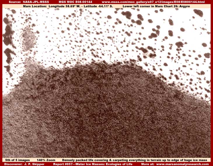
Now in the above fifth image from the E08-00144 strip, even though the distance tampering here is very effective at obscuring any normal size detail and the dark color forest of life area in this particular image has been subjected to additional serious resolution degradation tampering, at least the bright light color high albedo oversaturation tampering isn't present allowing us at least somewhat of a decent different view of this same type of false terrain.
What you are looking at above is the bottom edge of a huge dark spotted light color ice mass in the upper portion of my image and here again is a darker mass forest of life type terrain the ice mass sits in located in the lower part of the image and positioned right up against the water ice mass. This ice mass is right in the middle of the long original strip where it extends off each side of the strip completely dividing two different types of terrain in the upper and lower halves of the strip.
The real story here is the dark area you see in the lower half of my above image without the bright high albedo light color oversaturation tampering applied to it. Unfortunately, despite what official statistics may say, this scene is very distantly seen. Further, the resolution itself within this darker mass area has been degraded severely. So, while very tiny to start with, everything is all merged together and indistinct as to individual object detail. This kind of tampering is very successful at obscuring smaller size evidence, especially with nothing familiar to compare against in the scene, and so the true size scale is quite hard to determine, especially without the experience of looking at thousands of these images.
However, although this image tampering is quite successful at destroying individual object detail, it can't hide the broad scale aspect of the evidence as seen in the dark area in the above image. This extends all the long way down the lower half of the original official strip right off the bottom and sides. This is the same type of terrain as surrounding and adjacent to the water ice masses in this report and the colossal tubes evidence, just without the light color over saturation treatment.
Even if I had the space here to show you another image of this "forest," the dark color evidence seen above is basically the same as you would see all the way to the bottom of the strip. What you need to be aware of here is that this is something that engulfs everything so that no natural geological terrain is visible at all. Any ground geology under it is totally engulfed, covered, and filled by what ever this is. It is so uniform as a lumpy texture coating that it almost certainly a more effective blot out type tampering texture pattern. On the other hand, it might also be a live vegetation forest to or some combination of tiny vegetation forest and civilization evidence?
You should be aware that this scene also may consist of hard objects that are just too small to be seen here. Why do I say that? I will certainly acknowledge that I can't make out individual detail in the thoroughly merged and obscured dark mass and can't claim to see individual structures. However, this particular image's file size is much larger than normal even though the dark area constitutes only half of the image. That is also one of the reasons that I could not add another image to this report because this one image used up too much space.
When these unusually very high file sizes are encountered, this is usually a function of the software counting a great many individual hard objects with gaps between them within the pixel grid. For example, densely packed trees thickly entwined are not usually seen as individual hard distinct separate objects and the software tends to run across their uniform massed top surface where there are no significant gaps in between creating smaller file sizes. It is quite different where the software is counting both hard distinct objects or structures and the space gaps separating them so typical of building structures and civilization evidence. Very close examination of the dark area does indicated densely massed rectangular forms and patterns but this could be a form of image tampering that utilizes geometric forms in carpeting applications.
Whether a forest of something else, the bottom line is that this kind of aggressive covering of all forms of natural geology and in every niche in a very large area, regardless of whether or not it is a blot out tampering application, speaks loudest of aggressively spreading life of some kind being hidden, whether simpler biological life like vegetation forests or civilized life or both and that is all I'm trying to convey here. What that life is can be debated but what is absolutely certain is that this is not natural Mars geology of any kind in the darker color area of the image. By the way, the top of the original image also demonstrates yet another water ice mass, if you care to examine it for yourself in the original official strip.
If you have the graphical software to enlarge and clarify, I strongly encourage you to carefully examine the dark uniformly lumpy textured terrain below this ice mass in the official science data strip. It is basically like what you see in my fifth and last image above, just much more massive in scale. You will not see individual objects, so don't expect that. What you will clearly see is that whatever this is does aggressively and universally carpet and coat everything in the terrain. If not image tampering, then the only other feasible explanation for this is aggressive sprawling life carpeting everything so that only the life is visible, not the natural geology beneath it and it is the secret that the distance tampering is trying to hide from us.
The "forest of life" evidence suggested in this report is admittedly not definitive because the evidence is too distantly seen, it lacks any comparison frames of reference to determine true scale and individual object detail, and it has been obscured by degraded resolution. Even so, my conclusions on this are influenced in part by other evidence I've examined, so consider this aspect of this report as just an opening salvo in bringing attention to and generating questions as to what really constitutes this highly anomalous terrain around these enormous ice masses and other colossal objects I've reported on?
SPECULATION
If there may be massive incredibly aggressive forest of vegetation crowding out everything else in some areas of the South Polar Region, this tells us some important things. Assuming plants somewhat similar to what we are familiar with, any such massive amounts of vegetation would act as a tremendous oxygen pump confirming that Mars atmospheric breathable conditions are likely different than officially depicted and not nearly as thin and hostile to life.
Also, regardless of the artificially applied light coloration tampering, such vegetation is likely dark colored, absorbs more solar radiation than naturally reflective geological terrain, and therefore holds solar energy in its locale helping provide heat release in the general area for the water ice melt we see evidenced on these ice masses and helping create wetted flood plains that would be so favorable to vegetation growth. In other words, this is a description of a self supporting ecology cycle demonstrating that these water ice masses are indeed supportive ecologies of life.
So, we've covered a lot of territory in this report, even though it barely scratches the surface of the subject matter. The bottom line is that, contrary to what you have been led to believe, it appears increasingly clear that Mars is actually a world very much alive with thriving systems of life. This was actually indicated by earlier astronomical observations of seasonal green changes on the planet surface, especially in the South Polar region where the evidence in this report comes from.
Of course, those direct observations of those polar region changes were before the domination of satellite digital imaging data that is so easy to filter, control and manipulate came along to mold and control the perceptions of the unwary.
SUMMARY POINTS
(01) ... Basic recognition that spotted ice masses are water ice on Mars.
(02) ... These water ice masses also produce surface liquid melt water.
(03) ... These create favorable conditions for other life development and survival.
(04) ... These ice masses are actually reasonably plentiful on the surface of Mars.
(05) ... Liquid melt water means that temperature conditions may not be as officially depicted.
(06) ... Liquid melt water means that CO2 snow on the surface may not be as officially depicted.
(07) ... At least one multistage life form capitalizing on the ice masses is identified.
(08) ... That life form takes on different visual appearances in different stages of development.
(09) ... Massive ecology's of life of some kind are supported by the water ice masses.
(10) ... Forest of life could mean pumping oxygen and heat into the local atmosphere.
(11) ... Forests of life mean that official temperature and CO2 data may not be as depicted.
DOCUMENTATION
The evidence for this report was extracted from a total of four different representative official science data image strips as appears in the links below in the order they appear in this report. Note that some of these strips contain other anomalous evidence not imaged or mentioned in this report that is worth viewing.
www.msss.com/moc_gallery/ab1_m04/images/M0401718.html ... This is the M04-01718 science data strip from which my first and second images were drawn representing a typical dark spotted water ice mass or mount. This strip was chosen for its good clear view allowing some decent zoom factor on the ice mass located in the upper portion of the strip. Note that the first listed JPEG strip works and offers a view that agrees with my evidence here. The second GIF strip does not work. The third listed GIF strip with higher detail but slower loading time works but note that it has been flipped at official level and graphics software will be needed to flip it back to the orientation agreeing with my evidence here.
www.msss.com/moc_gallery/m07_m12/images/M07/M0702775.html ... This is the M07-02775 science data strip from which my third image is drawn demonstrating the more heavily melted water ice masses. The evidence I extracted is in the lower portion of the strip but the upper portion of the strip contains far more massive size ice mass evidence and is a very big clear image, so you may want to examine it for this additional evidence. Note that all three strips work but the third and last GIF strip has been flipped at official level and will require graphic software to flip it back to the orientation agreeing with my evidence here.
www.msss.com/moc_galleryab1_m04/images//M04-3317.html ... This is the M04-03317 science data strip from which my fourth image is drawn demonstrating the nutrient pool life evidence on the water ice mass. Note that the first listed JPEG strip works but the second GIF strip does not. The third listed GIF strip also works but it has been flipped at official level. Flipped or not, the view is essentially the same with little distortion and so I used the flipped version as a convenience without correction.
www.msss.com/moc_gallery/e07_e12/images/E08/E0800144.html ... This is the E08-00144 science data strip from which my fifth image is drawn showing evidence of part of an ice mass and a probable dark color dense forest of life of some kind bordering it on its bottom side. The evidence scene I used is in the middle of the strip but I strongly recommend those with graphic software that can zoom in and clarify examine all of the lower and upper halves of this strip to get a good look at the dark color solid carpeting life evidence that I did not image. Please choose the third and last GIF strip for this purpose for its higher detail content. All three strips work and all have the same orientation.
, Investigator
![]()