
MARS WATER ICE, CLOUDS, LIQUID
DROPS & LIFE: Part 2 of 2
Report #160
March 28, 2009
In the previous Part-1 section
we've examined the oh so slow and tiny incremental reluctant steps revealing
just a little water moisture presence on Mars. The biggest revelation (from
the secrecy point of view) was in the form of confirmed water ice but note
that it is only locked in the ground just below the surface.
Added to that was frost and even a little snow as well as a lot of repeat
visuals of water vapor clouds. There was even a suggestive revelation of soil
conditions that might even grow asparagus thrown in for a little boost water
presence message. Finally, even after the mission equipment failed, there
is a discovery of possible liquid water droplets or globules presence on the
underside of the lander in the shade on one of the landing pad struts and
that is still currently under debate as I write this.
As I warned viewers to anticipate in my Report
#138 back on 4/24/08 before Phoenix ever got to Mars, I suspected
that the Phoenix Mission was not real, at least as publicly stated. I suspected
it was a "designer" mission to confirm water presence to some limited
degree and that the real Phoenix Mission was elsewhere doing something else
in secret. I still suspect that but can't prove it and so that amounts just
to speculation and opinion on my part.
However, now that you have been exposed in Part-1 to the overall Phoenix Mission
as it has been publicly reported, I think for comparison we should now take
a look at some sample evidence as follows from the older MGS MOC data associated
also with water ice, water vapor clouds, and even bio-life on Mars. Of course
this goes a good bit beyond the Phoenix Mission revelations and even its asparagus
"possible" biological life theme. If you see any merit in this evidence,
keep in mind that scientists like those who are currently in debate over a
few water droplets on the lander pad strut minutia have already had their
chance at this older data and apparently did not find compelling or significant.
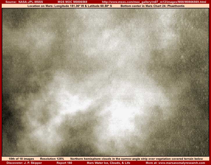
The above tenth report image
demonstrates a cloud formation on Mars. It is but one of several in the M08-06569
narrow-angle strip it was drawn from but also one of a great many in the wider
regional area as you will see. You've seen the now admitted to water vapor
clouds of the Phoenix Mission and now here's one in the older MGS data with
more to follow below. It's kind of pretty isn't it. Note that it isn't any
more or less than in the Phoenix data but just seen from above rather than
from below and in this older data.
However, although the cloud demonstrating water vapor presence is critically
important, look at that terrain under the cloud down the right side of this
image. Even as partially obscured as it is there, does that look anything
like the desolate and barren rock and soil geology you saw extending out from
the Phoenix site or as seen in the rover imaging? Even with the clouds obscuring
much of it, the above terrain evidence looks an awful lot like densely packed
biological forest life (vegetation) of some kind to me. How about to you?
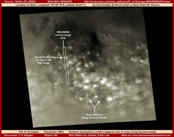
A single cloud or even several
in a strip, if you were desperately defensive enough scientist, could be foolishly
argued to be an aberration but how about an entire weather front? The above
eleventh image from the M08-06570 strip is the wide-angle companion context
image for the 10th image M08-06569 narrow-angle strip. Within it is shown
the location of the narrow-angle strip in the terrain and even the location
of the single cloud presented in this report's 10th image.
While the narrow-angle strip encompasses only several clouds and a 2.37 km
or 1.47 mile width according to the official statistics, you can see that
the wide-angle image demonstrates a whole cluster of many clouds over a wide
regional area. The official statistics tells us that this strip's scene is
125.61 km or 78 miles
across laterally. I suspect those measurements are reasonably accurate and
so that's obviously a lot of water vapor seen in the Mars atmosphere. At least
a lot more than can be explained by the official statistical position that
water vapor constitutes only a trace .03% of the Mars atmosphere.
Further, rather than a merged whole front rolling along, many of these clouds
(the lightest color ones) appear to be what I refer to as puffer clouds although
science identifies them as cumulus type clouds and you should as well. Cumulus
clouds typically form when warmer than the surrounding air rises (a thermal)
from terrain level and reaches a level of comparatively cool air in the upper
atmosphere where the moisture in the rising air condenses into visibility
as cloud vapor. On Earth cumulus clouds this thick can produce falling rain
or snow depending on the temperatures and other factors down there.
For example, when a small airplane here on Earth passes through an area of
these rising thermals, it can be a bumpy ride crossing over rapidly from one
rising thermal to another. The cause of the rising warmer air thermal can
be due to several factors but it is most often due to differential solar heating
at terrain level. Here on Earth a typical example would be open fields versus
areas of forest growth. The fields are more sunlight reflective and the forest
is darker and more sunlight absorbing. The latter creates increased heat absorption
and release over the darker forest area relative to the lighter color terrain.
A city can also create these conditions as some building roof angles and colors
are more sunlight absorbing than others, particularly the flat level tar based
roofs here on Earth creating localized warmer and rising air thermals.
In this location on Mars as represented by the 11th image, I suspect that
the terrain partially visible below the clouds in the 10th image is darker
color vegetation growth, likely living forest growth of some kind, that is
creating the rising air thermals that are in turn causing the cumulous type
cumulus clouds that are so sunlight reflective and light color in the above
11th image. That's a lot of water vapor in the atmosphere down there over
a broad area. Yet, remember that this is on Mars in the northern hemisphere
and water vapor isn't suppose to be more than a trace 0.03%. What do you think?
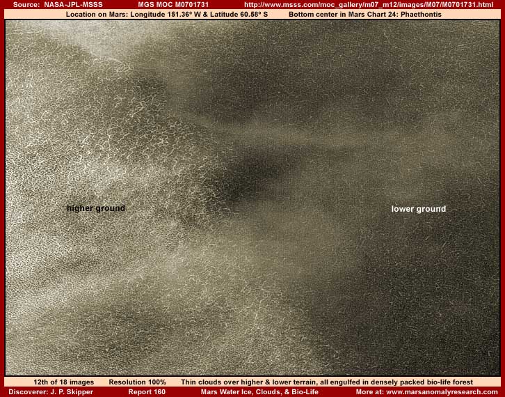
The above twelfth image demonstrates
a scene just below the middle part of the different MGS MOC M07-01731 narrow-angle
strip. The light reflective terrain in the left half of the image is slightly
higher ground rising to a low but raised ridge in the middle area and then
to the right dropping down into a depression partially in shadows. There are
low level thin clouds here that might even be classed as fog or mist flowing
from the sunlight higher ground over the ridge into the more shady depression.
In fact, the air slightly rising over the low ridge may be the primary cause
of the water vapor just beginning to form into thin but visible condensate.
However, although one reason that I picked this is because of the water vapor
presence, I minimized the water vapor visually in the above 12th image in
favor of showing more clarity of the terrain further below. Why? Because all
of the natural geological terrain is completely covered over from view by
some kind of densely packed biological life forest that is not familiar to
the Earth human eye. In other words, you are looking at bio-life of some unknown
kind unique to this different world. Certainly and obviously, by the process
of elimination, we are not looking at any rock and soil geology down there.
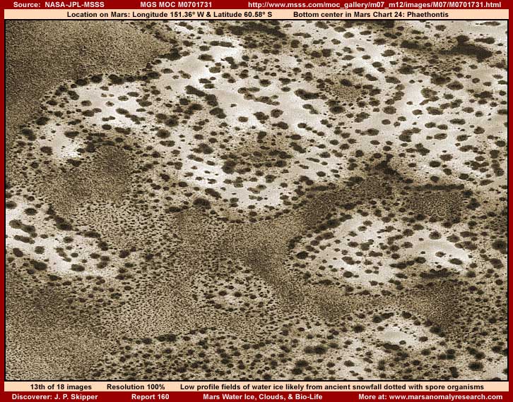
The above thirteenth image
is from the same M07-01731 strip as the 12th image but from the strip's upper
area. It shows only a small part of a very extensive lower profile ice field,
all of it covered with the dark spots you see here. The ice is the most light
reflective areas and it is water ice. The spots are a spore driven life form
organism that I've previously reported on that takes advantage of and flourishes
on these water ice masses.
The plentiful ness of the spot presence, the relatively equal distribution
of the spots over these ice masses without moving away from the middle areas
and concentrating at the perimeter edges, and the generally lower elevation
of the ice areas suggests that this water ice presence is probably entirely
from ancient snow fall. In other words, it has not recently been subject to
warming melt erosion conditions. Note that this site area is located in the
southern hemisphere and just outside the South Polar Region boundary.
This water ice presence was another reason why I chose this particular strip.
Why? Because it seems strange to me that scientists can so dutifully following
NASA's lead worrying about a little water ice presence around the Phoenix
Mission site when great fields of Mars water ice like this are present and
even covered with bio-life evidence. Yet visually obvious evidence like this
languishes without sufficient scientific attention even after they've received
the first basic signal via the Phoenix Mission that's its probably now okay
for them to see surface water ice along with water vapor clouds, etc.
Talk about not being able to see the forest for the trees when it comes to
Mars water presence! Meanwhile they're determined to hang onto prior manipulation
and conditioning (the current consensus) as though it was something real.
Worse, these are the people that we in the public defer judgment to when it
comes to matters of planetary exploration.
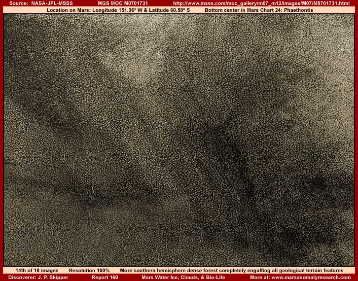
The above fourteenth image
is again from the same M07-01731 strip but this time from the bottom area
of the image. It doesn't demonstrate water ice or clouds but it does demonstrate
both the complete absence of visual rock and soil geology and the extensive
presence of densely packed biological life that has completely covered this
terrain including all of its variations.
Note that, although this evidence is in the same M07-01731 strip, the bio-life
demonstrated here is different appearing than in the 12th image. This is just
a sample of sunlight absorbing bio-life at its most prolific on Mars in an
area just outside the South Polar Region. Note that this evidence scene is
a far cry from the empty desolate sunlight reflective rock and soil geology
distances portrayed by the Phoenix lander and rover cameras. This forest growth
evidence is aggressive and prolific to put it mildly. This is the living Mars,
not the dead one some would like for us to believe in.
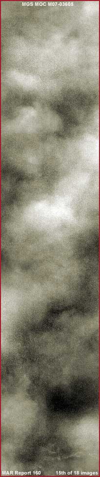
The above fifteenth image is of a different M07-02605 narrow-angle strip. It is reduced size to present the whole strip. As you can clearly see, it is full of clouds from one end and side to another. If I had presented this kind of atmospheric water vapor evidence at any time before the Phoenix water vapor cloud data was released and essentially admitted to, scientists would have no doubt insisted that this must be sand storm evidence because this much atmospheric water vapor couldn't possibly exist on Mars.
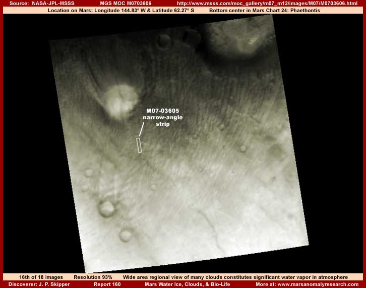
The above sixteenth image
is the companion M07-03606 wide-angle context strip for the above that 15th
M07-03605 narrow-angle image. Note that it demonstrates the location of the
M07-03605 narrow-angle image strip within it. Now this image appears to have
been artificially drawn back to a more distant perspective. This is likely
because doing so negatively impacts this particular type of cloud evidence
and makes it more difficult to recognize as clouds due to the cloud ripple
or banding formation patterns.
Remember that this imaging dates back into the late 1990s and early 2000s
when such water vapor cloud revelations and especially on a more massive scale
like this were a big no no. Since then and likely under pressure from verifiable
evidential reporting like that seen here at this website that keeps accumulating,
secrecy appears to have turned a corner inside their heads. That is no doubt
reluctantly and in tiny incremental steps admitting to Mars atmospheric water
vapor but it is there as evidenced by the designer Phoenix revelations actually
pushing water vapor. They may be dragging their feet a whole lot but they
are at least facing reality as best they can given their past.
No matter the obfuscation tactic here in this older MGS MOC data, the narrow-angle
15th image cloud evidence along with the Phoenix Mission admissions on water
vapor clouds tells us what we need to know. It tells us that the above 16th
image evidence is clearly atmospheric water vapor clouds and that these same
type of clouds cover a very large area. According to the official statistics,
this image's width is 113.09 km or about 70
miles across.
Now do I believe those measurement figures? My answer would have to be no.
Why? Well consider the very small size of the official M07-03605 narrow-angle
strip outline (the text associated with it is
mine) relative to that in the 11th M08-06570 also wide-angle image further
up. I suspect this 16th image has been drawn back to a much more distant cropped
out view purposefully making the evidence smaller in order to disguise the
cloud patterns for what they really are. So I suspect that the actual view
width we're seeing here is much greater than indicated by the official stats.
The point is that here again in the 16th image southern hemisphere just as
in the 11th image northern hemisphere, we see extensive wide spread atmospheric
water vapor clouds that go well beyond just very localized events. In other
words, what you are looking at in the 11th and 16th image wide-angle views
is a great deal more atmospheric water vapor on Mars than is suppose to be
there. Remember that water vapor on Mars is only suppose to be a statistical
trace .03%.
This difference between the unquestioned statistical data and the observed
visual reality is telling. It has all kinds of implications for true milder
Mars near surface temperatures and the potential for life. It is also yet
another evidential nail in the coffin of the secrecy and crafted false illusions
about this planet.
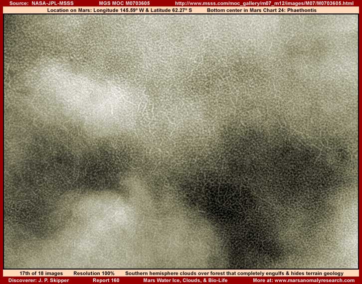
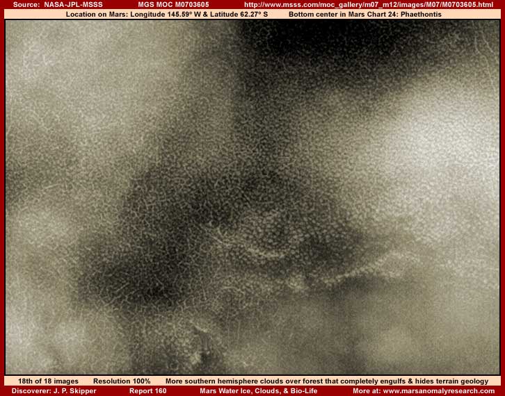
Speaking of life, the above
two seventeenth and eighteenth images are from the same M07-03605 narrow-angle
strip with all the clouds in it. The above two images are views partially
penetrating through the rather thick clouds. They offer sample views of terrain
sections below the clouds. Note that here again no identifiable sunlight reflective
rock and soil geology is visible, only densely packed bio-life forests of
some kind carpeting everything with their repetitive life patterns. Further,
especially in the last 18th image, note that the bio-life looks similar to
that for example in my Report
#023 posted back in year 2001.
Now all of you, including you scientists looking at this evidence, know that
you are not looking at rock and soil geology down there below those clouds
in these 17th and 18th images. Those patterns that repeat over and over again
down there mixed with meandering lines that also repeat over and over again
are carpeting and covering all undulations in the terrain completely hiding
the underlying geology from view. The patterns may look a bit strange and
unfamiliar to the Earth human eye but we both know that we are not looking
at natural rock and soil geology here. What we're looking at is forests of
aggressive life covering over the natural geological terrain.
The secrecy under years of relentless pressure is giving up and trying to
make an about face and is now trying to lead the way with the designer Phoenix
Mission creeping up on revealing and acknowledging Mars atmospheric and surface
water presence which then in turn leads to life presence. It may be in tiny
incremental and more digestible to scientists baby steps but it is there and
the turn can be seen by everyone interested except it seems so many of you
scientists. Yet it is your job to pick up on this and run with it. That is
what we, advocates and now secrecy alike, are all waiting for. Can't a few
of you inch forward just a little bit out from under the protection of the
consensus herd? After all, the world isn't flat!
What more do you want? The Phoenix revelations are the handwriting on the
wall. Are you waiting for secrecy leadership to come out in the full bright
light of day and admit to legal wrong doing and loudly and clearly tell you
and the world in unqualified terms that the hard frozen, dry, dead Mars was
just an unfortunate string of computational/statistical errors or a dream
and it's now okay for your consensus herd to wake up and see surface water
and life there? Surely you aren't that naive to think they would cut their
own throats like that just to make it safe for your personal reputations?
You can't live in fear and in the protective consensus reputation cocoon forever.
Yes things are getting more and more complex and yes this is the biggest thing
this planet has faced in its known (to us) long history. When this reality
tips the balance in the mainstream consciousness and really gets going there,
it will then be too late to get in front and lead. Then the rigid and unyielding
will be scattered as chaff before the wind and the rest following will just
be the incidental also ran's. Don't let this be you and your legacy of the
lack thereof.
If you don't want to become irrelevant in the greatest thing impacting Earth
human experience, then step up and forward with us now to seriously engage
and explore the evidence and its implications. If not, then you will eventually
become history's debris.
DOCUMENTATION
http://www.msss.com/moc_gallery/m07_m12/images/M08/M0806569.html:
This link takes you to the official M08-06569
narrow-angle science data strip from which my above 10th image evidence was
drawn. I used the third listed straight .gif strip. Note that the 1st and
2nd strips offer a flipped view at official level and should not be used if
your goal is to match my work.
http://www.msss.com/moc_gallery/m07_m12/images/M08/M0806570.html:
This link takes you to the official M08-06570
wide-angle science data strip from which my above 11th image evidence is drawn.
I used the 2nd listed angled .gif strip.
http://www.msss.com/moc_gallery/m07_m12/images/M07/M0701731.html:
This link takes you to the official M07-01731
narrow-angle science data strip from which my above 12th, 13th and 14th image
evidence are drawn. I used the third listed straight .gif strip. Note that
the 1st and 2nd strips offer a flipped view at official level and should not
be used if your goal is to match my work.
http://www.msss.com/moc_gallery/m07_m12/images/M07/M0703605.html:
This link takes you to the official M07-03605
narrow-angle science data strip from which my above 15th, 17th and 18th image
evidence are drawn. I used the third listed straight .gif strip. Note that
the 1st and 2nd strips offer a flipped view at official level and should not
be used if your goal is to match my work.
http://www.msss.com/moc_gallery/m07_m12/images/M07/M0703606.html:
This link takes you to the official M07-03606
wide-angle science data strip from which my above 16th image evidence is drawn.
I used the 2nd listed angled .gif strip.
, Investigator
www.marsanomalyresearch.com©
![]()