
MARS PHOENIX LANDING SITES
Report #138
April 24, 2008
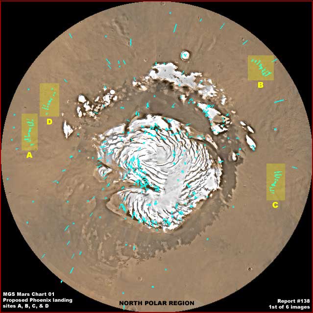
This report will be about both a certain prevalent bio-life growth in the Mars North Polar Region well out from the Cap and the Phoenix Lander's proposed landing sites in relation to it. The above first image demonstrates the MGS MOC global Mars Chart 01 view of the North Polar Region with the Phoenix proposed landing sites A, B, C and D highlighted and their designations labeled. The small aqua blue/green color marks identify the location of the locations of the R22 through S02 image strip sets in this region. Note their concentrations in the four respective proposed Phoenix landing areas. I believe that site "B" is the one finally chosen to set Phoenix down in.
For
more details on the Phoenix Lander go to this link:
http://planetary.chem.tufts.edu/Phoenix/lander.htm
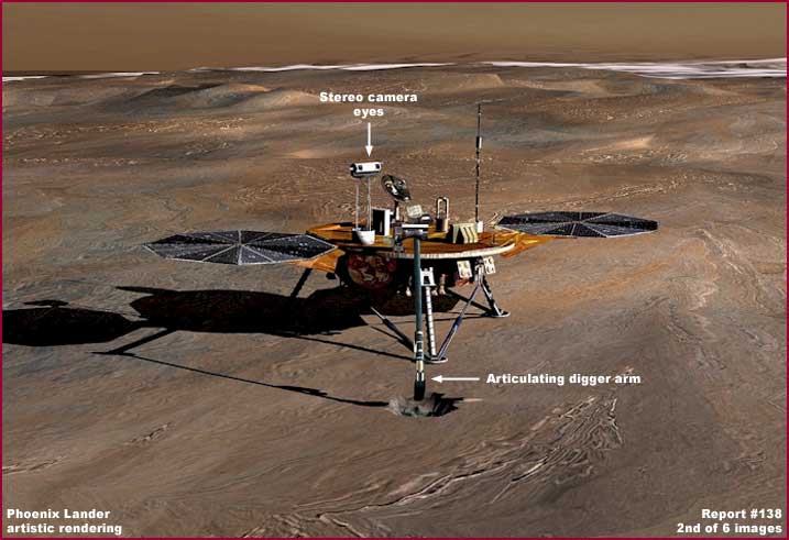
Note the above second image showing what the Phoenix Lander looks like. You should also know that the Phoenix Lander will be arriving at Mars roughly a month from now on 5/25/2008 if nothing goes wrong. Also, its decent in the planet's atmosphere to the surface will be a controlled and powered one suggesting more accuracy in the landing process as compared with other more crude landings that have bounced and rolled in.
If you don't already know, Phoenix is a "lander" and by definition it is not mobile and does not move around on the planet surface like the Spirit or Opportunity "rovers" do. If all goes well, it sticks to its selected landing spot and makes use of a long articulating arm to dig in the soil around it. It then tests and analyzes the soil it digs up. The primary purpose as officially stated is to determine if there is any water ice presence in that soil based on the logic that, if there is any water ice presence, it would logically be located in the frozen North Polar Region because it could have survived there over very long periods of time.
Sounds good but now let me weigh in with some personal observations on the official assumptions. Some on both sides of the fence will not like what I'm about to say but none-the-less my research indicates that the North Polar Region is very dry as compared to the South Polar Region. In other words, water ice is rare in the North Polar Region and abundant in the South Polar Region. This is likely in part because much of the water resources that may have once been in the North Polar Region have in ancient times been drained down south into the great Valles Marineris rift/crack system in conjunction with the rise of the great volcanic region to the northwest of the crack displacing surface water north and east of that point in ancient times.
I can only assume that, whether they admit it or not, the powers that be know this and so sending a lander to dig for water ice in a region with only very minimal water ice surface presence doesn't seem to me to make much logical sense. It would have made more sense to send such a probe to the South Polar Region for this stated water ice discovery purpose. On the other hand, if bio-life is crowded into the South Polar Region as my research indicates that it is, then finding a safe landing site there with questionable accuracy decent technology could very be problematic and a reason to not go there.
However, while the South Polar Region may be a riot of bio-life taking advantage of surface water presence there, that is not to say that there is little bio-life presence in the North Polar Region just because it is colder and dryer. So, with this thought in mind, take a look at the next images below.
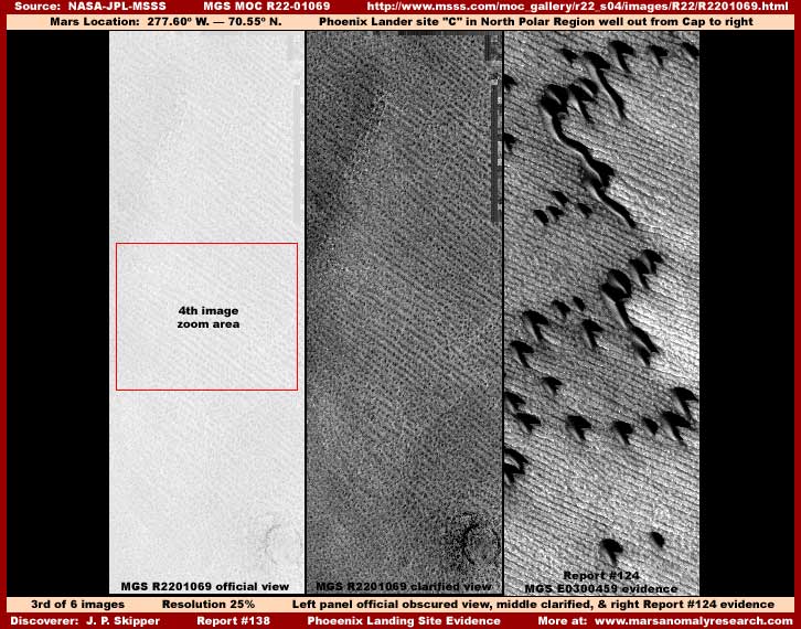
In the above third image, you see three different looking evidence panels. Each represents a section of a image strip from one side edge to the other but reduced in size to be able to present them side by side. The two panels on the left are from the MGS R22-01069 narrow-angle strip that is in turn from the "C" group of Phoenix proposed landing sites. Of those two panels, the one the left is the official very obscured view and the one of the right is the same scene clarified by me to better reveal the bio-life row evidence that blankets the terrain from one side of the strip to the other.
You should know that all of the imaging of the proposed four "A" through "D" Phoenix landing sites are very heavily obfuscated to a degree well beyond that which is normal in the rest of the MGS MOC narrow-angle closer imaging. Further, this obfuscation tactical extends to the companion distant wide-angle strips as well. This obfuscation is normally accomplished via incredibly poor quality resolution and then drawing back to an extreme distance so that individual objects thoroughly merged together just to make sure that the imaging is essentially useless as to any kind of ground level truth. The illlusion conveyed is that this terrain is just relatively smooth geology safe for landing purposes.
A obfuscation tactical less often used (and less effective) is the introduction of the white smudge color haze you see so evident in the above left panel. As it turns out that is good for us because this form of obfuscation can be partially defeated revealing a little more ground detail as I have done in the middle panel. The view still doesn't allow individual object detail but it does reveal the coarse parallel row pattern of the terrain evidence. This better view is also in part enabled by the fact that this evidence is even larger and more coarse than it appears in the official image strip and it is overcoming the poor resolution and distancing obscuring techniques.
However, the third panel on the right in the third image is evidence from my 2007 Report #124 titled "Mars North Polar Bio-Life-2" and is drawn from the MGS E03-00459 narrow-angle strip for comparison purposes here. The reason that I've included it here is that I want you to go to that report and look at the evidence there both as to the parallel row patterns in the terrain and the so called "dunes" evidence on top of that row pattern evidence. This E03-00459 evidence is actually not located at any of the proposed Phoenix landing sites but around on the left side of the Cap in the terrain about midway between the Cap and the Phoenix "D" proposed landing site and demonstrates just how widespread this type of evidence is in the North Polar Region.
This report will in a way act as supplement to that previous report as this one gives a clearer picture of what the "dunes" evidence in the previous report is positioned on top of. It gives you insight that the so called dunes at official level are not that at all but something else entirely and likely something living and unknown to us.
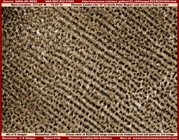
The above fourth image demonstrates a closer colorized (by me) view of the parallel row evidence, again from one side edge of the strip to the other. This is from the same R22-01069 strip in the third image left and middle panels. We may not know exactly what this evidence is but there is one thing for sure, it doesn't look like geology at all.
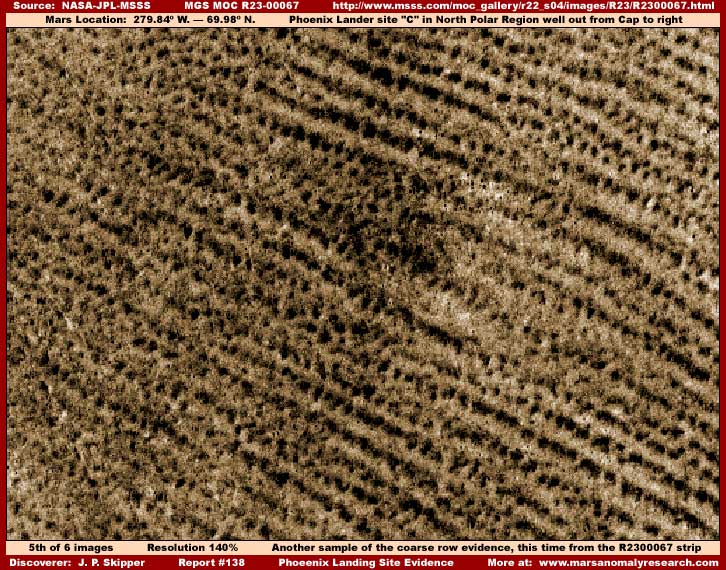
The above fifth image is from the same proposed Phoenix "C" landing area but from a completely different R23-00067 narrow-angle strip. I've included it here just to demonstrate to you via another sample that this type of coarse parallel row evidence is plentiful and not limited to just a single image strip. Sorry about the fuzzy indistinct quality but that's the way it is in all of these obfuscated strips. We are fortunate that just a few strips shown here escaped the worst of this allowing this little bit of truth to come through.
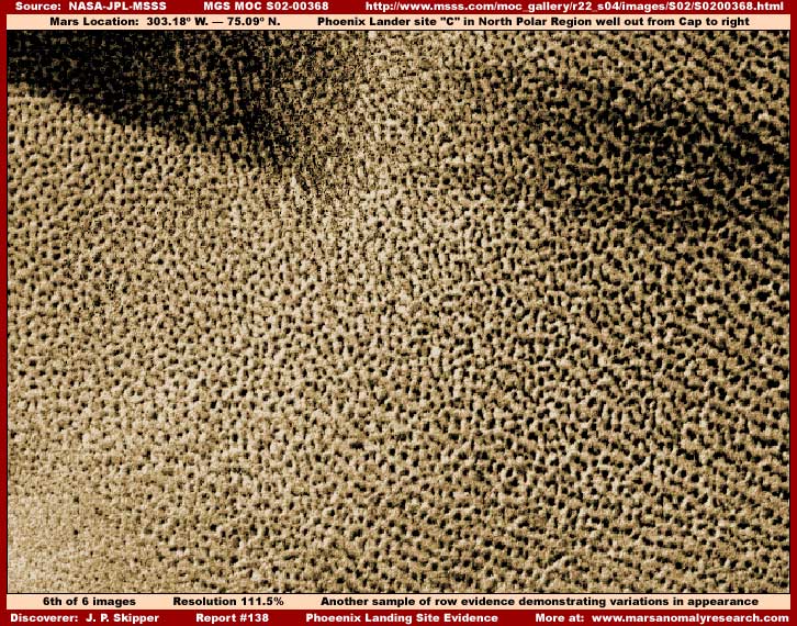
The above sixth image is again from the same proposed Phoenix "C" landing area but from yet another different S02-00368 narrow-angle strip and with a bit more distant view. This sample is included here to demonstrate how this same type of evidence can have slightly different appearances. Note the more pronounced row patterns on the right and the more tangled non row pattern look to it on the left but it's all the same evidence.
In my opinion, this evidence is biological life of some kind unknown and unfamiliar to us that specializes in the dryer colder conditions of the North Polar Region. It is certainly not the only bio-life in that region but it is one of the most prevalent and covers vast areas in the terrain out and away from the Cap. Of course part of this impression is geared to the fact that its large coarse textures and patterns help it overcome the very poor resolution imaging allowing us to see enough of it to consider it as bio-life as opposed to geology. Something finer textured than this in this poor imaging would only have a smoother appearance to it and not be recognizable as bio-life at all.
This type of super dense concentrated evidence is present at all of the Phoenix landing sites. However, the degree of tampering is more pronounced and effective at the A, B and D sites rendering identification of even this larger coarse evidence as much more problematic. It's just that the "C" site had a few strips that demonstrated this evidence a little better than the others. So this encouraged me to report on it and why I used this particular site "C" as a source.
In these areas and many others in the region, when there is a pit or impact crater, this evidence intrudes into it, engulfs it, and runs over it softening it into a crumbly looking appearance quite different looking than raw natural geology. This and its prevalence around the region is yet more evidence that this is dynamic bio-life growth we are looking at here and not geology.
Once all this is understood, that then offers insight into the "dunes" evidence seen distantly in the right panel of the third report image and in Report #124. The fact that these dune looking objects are each positioned isolated from each other on top of this row pattern evidence is very telling about what they may be and for sure what they are not and just how tough this row pattern evidence really is to be able to endure the presence of these huge objects on them without apparent visual damage.
But, all of this life insight brings us back around to the Phoenix Lander mission itself and questions regarding it. Regardless of whether you buy into the row pattern evidence as being life or not, look back over the images here. Whether life or geology, note the very obvious rough uneven quality of this terrain with no break in it for the needed smoother landing sites. Do you really think for a minute that a tender lander like Phoenix could successfully land in such rough uneven terrain even with a power controlled decent? This kind of terrain is present in all four landing sites regardless of their trying to hide that fact with all of the imaging obfuscation.
I simply cannot bring myself to believe that they would genuinely attempt to land something as tender and problematic as the Phoenix Lander in this kind of rough uneven terrain. If they're actually going to try it, then someone is either incredibly inept or the lander is nothing more than a pawn to be sacrificed to other probable onboard but secret from us goals. If those secret goals are relatively benign such as say something like miniature aerial camera surveillance to be launched from the capsule on its way down or landing in a another undisclosed location, that is one thing.
However, what if some ruthless types here on Earth are targeting these vast bio-life fields with Earth microbes destructive to them something like the story of the AIDS strain dropped into Africa to depopulate it! Who's to know or prove it? If pressed, they would just claim that a mistake was made and it sometimes happens.
I don't know about you but I could really get cranked up big time if it was the latter scenario being played out. Further, regardless of your ethical values, simple survival instincts dictate that such a scenario playing out on another world with highly intelligent life on it could reap the whirlwind here on Earth affecting us all, ...permanently. On the other hand, maybe Phoenix is headed for some "undisclosed" location and all the "proposed" landing sites are just misdirection.
That's the problem with secrecy and those practicing it, we here in the public just don't what is going on or how much risk we are all running. Worse, the science and academic communities we tend to rely on are just too naive and mesmerized by the money funding and power to seriously question what may be going on right under their noses. Those doing the secrecy are isolated from us all and there are no public checks and balances to encourage restraint in them. You know as well as I do that there are people here on Earth who could and would do such sorry crummy things and justify it as for our own good and manifest destiny.
So this reporting has covered a number of issues. First is the rough parallel row bio-life issue itself here and then second some additional insight into the "dunes" evidence in Report #124 and finally the mystery and question as to why the Phoenix Lander is officially headed for landing in such rough terrain conditions. Truthfully, as important as they are, the life issues pale in comparison to the Phoenix landing site questions and intent.
Something has got to be done about this secrecy and what is being withheld from us and what may be being done behind our backs in the name of being on our behalf. We need to know the level of risk that we are running and what others are involving us in.
DOCUMENTATION
http://www.msss.com/moc_gallery/r22_s04/mc01.html: This link takes you to MGS Mars Chart 01 for the R22–S04 image strip sets with active links including those to the Phoenix landings sites A, B, C, and D.
http://planetary.chem.tufts.edu/Phoenix/lander.htm: This link takes you to lot of official level information on the Phoenix Lander design and components and purpose.
http://www.msss.com/moc_gallery/r22_s04/images/R22/R2201069.html: This link takes you to the official MGS MOC R22-01069 narrow-angle science data strip that is the source of my third report image left and middle panels and fourth report image.
http://www.msss.com/moc_gallery/r22_s04/images/R23/R2300067.html: This link takes you to the official MGS MOC R23-00067 narrow-angle science data strip that is the source of my fifth report image.
http://www.msss.com/moc_gallery/r22_s04/images/S02/S0200368.html: This link takes you to the official MGS MOC S02-00368 narrow-angle science data strip that is the source of my sixth report image.
, Investigator
![]()