
FORESTS OF LIFE ON MARS
Report #023
August 24, 2001
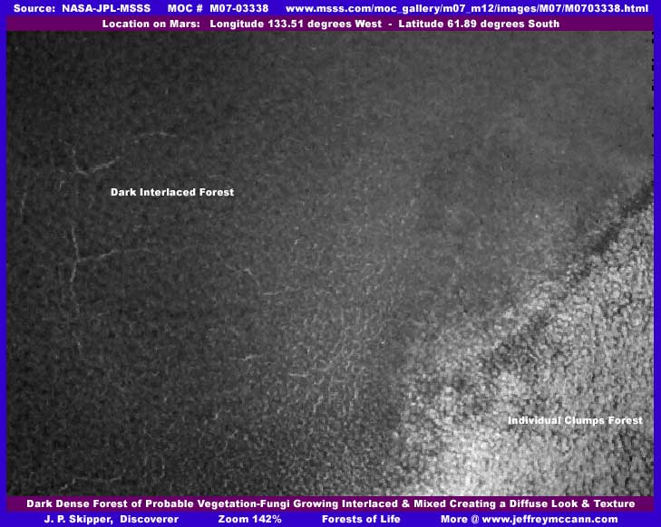
Let me set the stage for the evidence of natural life on Mars you will see here in the three included images. Traveling from the upper to the lower part of the original image strip, this is a scene where relatively level land occupies about 50%-60% of the upper part and the lower 40%-50% portion crosses over the rim of a large shallow crater and goes down the gentle inner slope of same. However, this is not readily apparent when viewing the strip because 100% of the entire strip area is covered by a dense carpet of what is almost certainly vegetation or life of some kind. In other words, no actual land surface is visible at all. The upper dark area is the area outside the crater and the lower lighter areas are the crater rim and going inside.
I would have liked to include a large portion of the original strip here as a fourth image so you could get the larger picture. But, even at smaller sizes I discovered that PhotoShop sees very high individual detail (no doubt hundreds of thousands of densely packed individual plants) and the file size of such a image is way too large to include here. So, what I have done here with the three images is to divide the most representative area of the strip into three parts with the second image scene taken right under the first and the third image scene taken right under the second. Note also that the overall resolution of the strip is not very good and a zoom of 142% was as close as I could get before individual detail began to suffer just too much.
With that said, the first image at top here is of just a small portion of the upper 50%-60% of the strip which is a solid uniform carpet of dark plants. Note that little can be seen of individual plants, just vague lumps within the overall dark mass. I suspect that this is because this is a different species than seen further down this strip. A species that has a finer (smaller) texture to its extremities so that any detail of individual plants are really impossible to see at this distant resolution. Further, this is a species that doesn't mind mixing in and interlacing with other plants of its own kind in the struggle for space and light creating a intermingled diffuse look and texture. On the other hand, the light colored area in the lower right corner is the beginning of the crater rim and the different species of life that covers it completely as shown in better detail in the second image below.
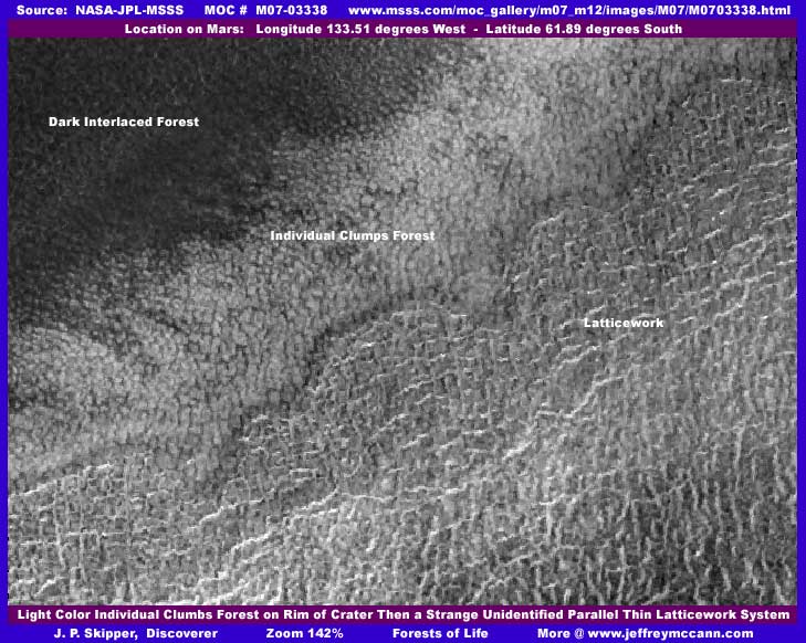
In this image, in the upper portion you see the dark plant species forest ending and the ridge rim of the crater covered by these lighter colored densely packed individual clumping plant/fungi/lichen forms that are very compact and do not mix in with their neighbors but keep a defined and very narrow air space between themselves and others. These plants appear to be the same as the probable huge fungi/lichen growth in the South Polar region that I have shown in my 6/29/2001 report out of strip M08-04110 which can be seen HERE. In fact, this forest here is located in chart #24 "Phaethontis" one chart up from the South Polar region making them distant neighbors. They are likely the same species although they can be seen much better in that previous report than in this one because the resolution in this strip is not nearly as good which prevents us from getting as close. Make no mistake about it though, these are all very large plants the size of great buildings here on Earth and far larger than we are used to seeing.
Like those in the previous M08-04110 report, these plants here seem to thrive best on higher ridge ground and form individual isolated but still densely packed clumps. Even though ground can not be seen, I suspect that, like the high ridge location in M08-04110 that the clumps there preferred, the height of the top edge of this crater rim may combine with correct temperature perimeters and prevailing winds to probably sweep some moisture out of the air at certain times of the day in the form of snow settling on the crater rim and the plants themselves. Mid day solar radiation may then do a melt of this snow forming water which feeds the fungi plant like forms allowing them to flourish while any excess runs down the crater rim slope. The broad flattened tops and narrow interspaces between each plant probably encourages and facilitates this process. If this hypothesis is correct, this forms a very stable long term life support system dependent on thin atmospheric moisture and not on water from underground. Further, it is logical that other life forms, if any, may take advantage of this with a whole ecology at work in and around this stable water system.
While the densely packed clumps on the crater rim line are pretty obvious even at this distant inadequate resolution, what is not obvious at all or so easily identified is what I have called "Latticework" right below the clumping species. This just for convenience reference term very loosely based on looks is just for the lack of a better term and certainly does not in any way satisfactorily describe these objects or identify what they are. Note that, in this scene on the crater ridge rim, the orientation of this multitude of objects is basically from left to right parallel to the crater rim. However, in the next third image below, which is primarily down the rather gentle shallow crater inner wall slope, the orientation of what appear to be these same objects changes to primarily down the slope and thins out. Since we are looking at a lot of densely packed carpeting forests of life in this strip, there is some logic supporting a consideration that this great multitude of "Latticework" objects may also be plant forms of some kind, just too unfamiliar and strange looking to identify. This may be true and can not be ruled out.
On the other hand, since I have satisfied myself now that active civilizations exist on Mars and of course gravitate to where ever there is water, for me there is also the question of whether these are artificial constructs of some kind? If you will look closely in both the second and third images, it can be seen that some of these horizontal white lines appear to possibly be off the ground horizontal structures supported by multiple vertical columns. Could these objects be a raised air foil screening system of some kind rising above the level of the clumps forest presenting a broad front to the prevailing wind that also catches and extracts moisture from the air via temperature differentials? In other words, something artificially taking advantage of the same situation the clump plants are doing naturally? I certainly don't know but I am suspicious and would like you to at least consider the possibility. Of course, as always, you must ultimately decide for yourself.
However, there is another observation to point out here with this "latticework." Even though the resolution is poor and the distance great, compare the poor detail of the tightly packed clump plants with the much poorer detail of the latticework objects. There is simply too much difference between them that can not be adequately explained by the strong difference in the clumps and latticework shapes alone. The latticework detail is far more degraded in resolution than the clump plants. I do not see any extensive evidence (a few small spots though) of the usual image tampering techniques but I still suspect tampering here. For example, it is possible to run this latticework scene through some lighting (too much light saturation) and blur filters in graphics programs to cause this degraded look. Unfortunately, I can not be definitive one way or the other about this but thought that you should at least be aware of this possibility.
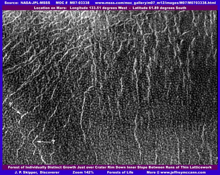
When I first discovered this image strip, I assumed that the great multitude of individual objects you see in the above third image (only a small part, they go further down in the strip) are just less well developed forms of the larger tightly packed clump plants on the crater rim top. They resemble those plants a bit in this view and certainly practice the same basic isolation spacing principle from their neighbors. Also, like the clump plants, they are more sharply defined on their edges to than for example the forest of dark vegetation in the upper part of this strip. I thought that they may be smaller because the changing environmental conditions going down this gentle inner crater wall slope are less favorable and so they are less well developed. Alternatively, they also may be completely different plants or a different variety of the same species. This may very well be the case to.
But, I am reminded that this particular well defined smaller object pattern is not evidenced in the M08-04110 discovery and especially not in such massive quantities. The quantity of individual objects here in this third image is so high that my lowest file size for saving this image was almost double the norm! I am also reminded that the biological life evidence in M08-04110 was not covered up even though civilization evidence there was. To me, that means that, like water which I have found plenty of, this evidence of biological plant life has been purposely left for others to eventually find if it can be adequately separated from the civilization evidence by spot and area tampering. In other words, it is ultimately meant to be approved discovery material even if there is professed denial at the moment. So, have they gone one step further and actually tried to create a illusion of these being plants here when they are actually not and something else entirely? These suspicions were strong enough to make me go back and look very carefully again.
The first thing I noted is that, even though there is a difference in girth of the individual darker objects with larger ones being twice as large as smaller ones, the sizing stays rigidly within these tight perimeters. Further, there is a rough common height and very consistent spacing factors. Also, even at such distant small blurred view size, each object continues to be surprisingly sharply defined at its edges even more so than the larger clump plants. So, despite their at first glance random appearing pattern, there is a awful lot of regularity and uniformity. Of course, these factors could also be true of plants having nothing to do with civilization. But, while the light colored lines now oriented down slope appear to be just that on a straight down view on them, a slight side view as represented in the lower left corner of the above image (pointed out with arrows) shows some of the lines being made up of extremely tiny individual objects rather than a continuous long stringy object as first appears.
Could these be chains of buildings or similar structures having to do with the distribution of water from the crater rim? If you have a string of buildings and back away from them far enough in a aerial view, they begin to blur and run together and appear as a continuous stringy object. Is that what is happening here? I have seen this resolution tampering technique used over and over again in the MOC imaging, particularly to get buildings lining up around the edges of water discoveries and which are not already covered up by a fog or sweep type of covering tampering to run together in a continuous chain that then appears to blend in with the geology such as appearing as a low ridge line. The much larger water is little effected by this technique but the tiny buildings are drastically affected and blend into the true geology. Don't get hung up on the lack of roads here (there are a few dark corridors) as that can be explained by a more advanced means of travel. As for the varying odd shapes of the objects and random appearing placement, that can be explained by many social factors. Remember, this is not Earth but another world with its own way of doing things.
Now don't get me wrong here, I am not saying that I see buildings here because I don't. I am also not saying that this is tampering. The resolution is simply too low to be able to be conclusive about such considerations. What I am saying is that I am highly suspicious and just want you to also consider the possibility that what we are looking at here in this third image may possibly be artificial structures rather than plants. I base this caution on my experience at viewing these MOC images and my experience with the huge amount of image tampering in them that almost everyone else seems to be unable to see and/or dismiss it as any factor at all. I am just presenting this artificiality possibility as a alternative consideration. On thing is for sure, the bottom line of what we are looking at in all three images here definitely represents life of some kind whether a forest of biological native plant/fungi life forms or high density civilization or both.
Finally, I would like to add that the M07-03339 wide-angle context image strip that goes with this M07-03338 strip shows evidence of a lot of dark ground all around the region in this general area. I suspect that even better evidence of forests of natural biological vegetation/fungi/lichen life forms could be found around in this area. Also, for those interested, another MOC strip M07-03605 a small distance west of this position shows similar (a bit less clear) anomaly objects all throughout the strip. If pressure can ever eventually be applied to get legitimate data before the public at true high resolutions and without image manipulations that degrades viewing, this general locale should be among the first targets considered for true definitive imaging.
DOCUMENTATION
My data is drawn from NASA/JPL/MSSS's official second listed sinusoidal projection best quality gif original strip located at http://www.msss.com/moc_gallery/m07_m12/images/M07/M0703338.html. Note that the first listed sinusoidal projection medium quality faster loading jpeg strip works just fine to. You will be able to get the big picture and confirm my imaging here in either the first or second strips without the need of a graphics program to zoom in on anything as the original is large enough to view these anomalies. You will also be able to see the companion M07-03339 context strip there to and see the wider locale. However, the third listed not map projected gif strip has been flipped both vertically and horizontally at official level which can create considerable distortion and you will need the appropriate graphics program to flip it back to the correct orientation if you wish to use that strip. I have not accessed this data through any other site such as PDS or USGS and can not comment on what may be there. Good luck.
, Investigator
![]()