
DENSELY PACKED LIFE EVIDENCE
Report #042
August 30, 2002
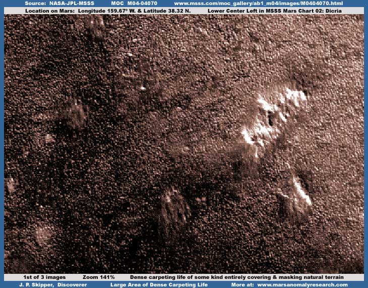
As you can see in the above first image, this terrain is completely covered by a dense packed profusion of life of some kind so that essentially no natural geological terrain is visible at all. What you are looking at is densely packed individual hard objects in the many tens of thousands but seen from a great distance forcing them to a tiny size that merges together. The larger irregular light color objects sticking out of this sea of life appear to me to be image tampering covering and obscuring groups of objects originally large enough that they still could have been seen properly even at this distant poor resolution and so of course they had to go. So don't get to thinking that these are natural land forms of some kind.
The first and third images here are essentially from one side of the strip to the other capturing the scene all the way across. There are so many thousands of hard objects here that these images are double normal file size and that makes them slow to load even though I have the file size as low as I dare take them without sacrificing image quality too much. So be patient as it can't be helped. Also, because each image is so large in file size, I can't load this report down with very many of images. That's just as well because this region of life is large covering a huge area and there are quite a few other image strips of this evidence as per the list further down this report with links for those who wish to take a look at it.
Each of these strips has the same extreme distance problem and therefore none are any better than others for getting a closer and better look at this evidence. Likewise, because these objects are so densely packed close together and appear to be of a similar girth and height, the distancing technique has been very effective in merging them together in a blurred overall mass. Further, the limited resolution prevents zooming in very close to try and differentiate individual objects. So, unfortunately, what you see here in these sample images here is essentially the same as you will see in the other strips without any significant improvement.
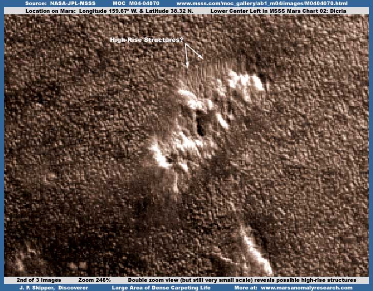
The above second image demonstrates how relatively ineffective double zoom has been in resolving objects in this sea of similarity. On the other hand, the wad of very light color mishmash of "stuff" seen here in the center of the image has what appears to be very tall rectangular not natural tower structures sticking out of the top of it (as I've pointed out with arrows) that look, even at this great distance and poor resolution, very much like high-rise buildings very distantly seen. This type of evidence demonstrates the true distant scale involved here. Get down very close to the screen and check this out close-up for yourself. The tiny towering objects in this white mass area can be seen just slightly better because we are now beginning to see a little of the sides of these structures rather than just the tops out in the sea of similar objects. Add to this information the factor that most of the thousands of tiny objects in the surrounding terrain appear to be resolving into rectangular structures and you can perhaps better see where this evidence is beginning to point.
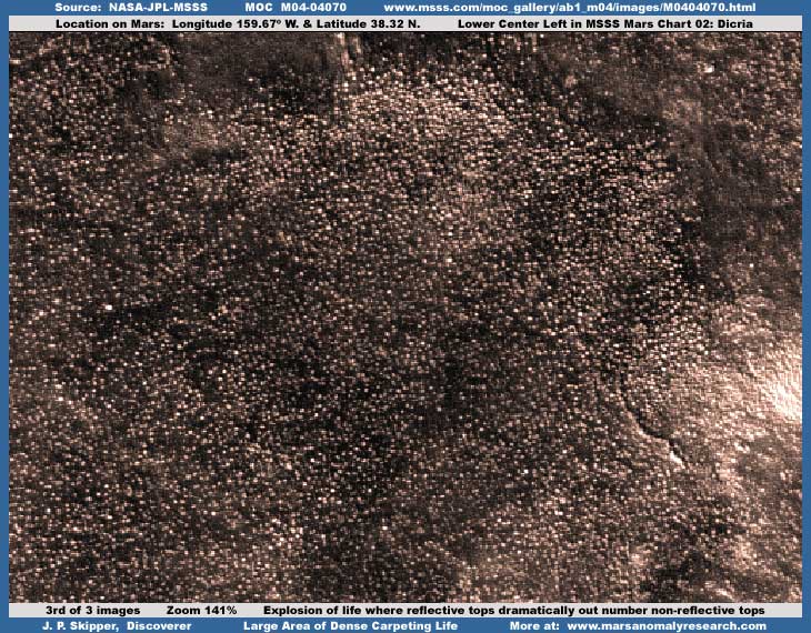
The scenes in the first and second images here are characterized by a majority of the individual objects tops we are seeing being not very light reflective. The typical scenario in most of the various other strips listed below containing this evidence leans in favor of either equally divided between less reflective and more reflective or a slightly greater number (say 60%-70%) of non-reflective object tops, all thoroughly mixed together. However, the above third image here is unusual and demonstrates the reverse in what looks like a very healthy explosion in this area of the more reflective object tops where they seem to out number the less reflective tops by a 70%-80% or more margin. Obviously, the life in this scene is very healthy and in full surge.
Some of this light reflectivity difference may be explained to small extent by the sun angle but remember that all this evidence is from the same strip in a area of Arcadia Planitia typified by relatively flat level plain terrain and a more level terrain factor would serve to minimize sun angle differences. Likewise, this particular scene could be on a unseen mound elevation that could effect sun angle as the angles of the slopes in the mound changed in various areas. However, while there are differences in numbers and density in certain areas, there really isn't any significant differences in the reflectivity of the more reflective individual objects regardless of their location in this scene. Further, this factor is confirmed in other similar evidence both in this and the other strips where level terrain is clearly present. Rather, it seems that the degree of reflectivity is more determined by the object itself.
Unfortunately, as is the case with the second image, zooming in on this image strip more than 141% doesn't seem to help much because of the quickly degrading resolution, which tends to merge everything together even more than you see here. It is the same with the other strips as well. I'm satisfied that this is by intent. Still, if you get down close to the screen and examine the above image #3 evidence very closely, you can see that in various areas of the scene the objects are definitely resolving into rectangular structures. Further, these all appear to be physically relatively smooth hard objects as per their reflectivity. Although the evidence is admittedly too tiny to be conclusive, this is still very suggestive that this is a sea of buildings very distantly seen and the most likely scenario is that this is probable civilization evidence.
It matters not at all that we are possibly talking about countless thousands upon thousands of buildings here. Remember, this is Mars, not Earth and it has physical history quite different than Earth's and it is logical that life has adapted along different pathways than on our planet. So, if you are thinking that this is impossible simply because of the numbers involved, then you are thinking inside a box of your own making that has little to do with any Mars reality and you need to open your mind to some more objectivity. Mars is unique just as is every other planet in our system (including ours) and survival and the forms it takes is dictated by its unique conditions, not by our human prejudices for what is familiar, comfortable, and therefore easily recognizable and acceptable.
In the Part II "Documentation" section of this report, you will see the MSSS Chart #2: Diacria image. There you will see the dark area many miles long and the type of life evidence you see here makes up the bulk of all of this dark area. This particular strip was drawn from this dark area and the life samples I've imaged for you here shows relatively healthy life evidence. However, in the other evidenced strips listed below there are also spots and areas where this life appears not to be healthy but deteriorating and/or dead. Also in Part II is the M04-04071 wide-angle context companion image and there you will see the relatively sharp demarcation line between the dark area and the surrounding light very reflective terrain it sits in.
This very light color highly reflective surrounding terrain shows what appears to be evidence of dead heavily knob (on a tiny scale) covered terrain that is almost certainly remnants of the hard object living life evidence you see here drawn from the dark area. North and south of this dark area are level plains. The plains to the near west seem to broken by huge wide apart ancient fracture zones and southwest by smooth low rolling landscape probably produced by the fracture zones in the ancient past. To the east are other smaller dark areas that suggest the possibility of life but are not imaged well enough to make a call. South of these smaller dark areas and east of this life evidence is terrain characterized by a very flat plain of thousands upon thousands of irregular elongated troughs or pit systems that seem to follow crossed geometric patterns. All are dry with no apparent water. They may be a natural result of some unknown geology or possibly the result of civilization surface mining but the imaging is again just too distant to be sure.
Scattered in this particular dark area, especially in its eastern areas, are pits or craters filled with what clearly appears to be water ice but no significant liquid surface water. The water ice pits or craters seem shallow and/or filled near the top with the ice, which suggest that water is not too far under the surface in this area but that it is also clearly cold in this region. Yet, in the images here and in most of the other strips listed below, the dark area life evidence demonstrates little snow or ice such as may be in the outer surrounding terrain. Further, on these plains, which NASA/JPL/MSSS indicates are subject to dust storms, there is little evidence of dust and the life evidence area also shows no signs of the collection of said dust or sand. If the dust storms official scenario is true (I seriously question it), this could be a further indicator that we may well be looking at civilization evidence here since it is able to keep its physical boundaries clear of dust storm effects.
Perhaps the great fracture zones at the west end are the key? Perhaps they created a rift system at 90º angle to the main fracture zones that could not sustain itself in the ancient past and closed up. Perhaps fracture zone pressure pushes thermal heat and/or water near the surface and formed a lake depression system along the line of the rift that slowly drained the nearby terrain. In time this rift lake may have filled with sediment filling in the rift and its lake but the water (and perhaps a measure of heat) is still close to or at the surface allowing life to survive on top of the now buried rift depression? In earlier eons, the water draining by capillary action just under the ground surface toward the rift depression may have allowed life and/or civilization to tap into it and exist in the outer surrounding terrain but now is retreated and confined to the dark area immediately above the rift? Interesting speculation but just that for the time being as the evidence is a little too insufficient to extrapolate with very much accuracy on this.
Now below is a list of links to the other strips of this dark evidence area. In these you can check out a great deal more of this evidence than I've sampled for you here. As you can see by the number of strips, this area is of considerable interest to those doing the MOC camera management. I suspect we can assume they are knowledgeable about this life evidence whether they will admit it or not and that they possess much closer imaging of this than has been released to us.
(01) ...
M08-02288
... http://www.msss.com/moc_gallery/m07_m12/images/M08/M0802288.html
(02) ... M02-03465
... http://www.msss.com/moc_gallery/ab1_m04/images/M0203465.html
(03) ... M14-01413
... http://www.msss.com/moc_gallery/m13_m18/images/M14/M1401413.html
(04) ... M09-01435
... http://www.msss.com/moc_gallery/m07_m12/images/M09/M0901435.html
(05) ... M02-02364
... http://www.msss.com/moc-gallery/ab1_m04/images/M0202364.html
(06) ... M01-01876
... http://www.msss.com/moc_gallery/ab1_m04/images/M0101876.html
(07) ... M00-00333
... http://www.msss.com/moc_gallery/ab1_m04/images/M0000333.html
(08) ... M07-03617
... http://www.msss.com/moc_gallery/m07_m12/images/M07/M0703617.html
(09) ... M10-01108
... http://www.msss.com/moc_gallery/m07_m12/images/M10/M1001108.html
(10) ... M12-01631
... http://www.msss.com/moc_gallery/m07_m12/images/M12/M1201631.html
(11) ... M07-01626
... http://www.msss.com/moc_gallery/m07_m12/images/M07/M0701626.html
By the way, when you are looking at these official science data strips, you should be aware that the third listed straight vertical GIF strip at the MSSS site has consistently been flipped at official level. This can be determined by comparing it with the first two listed strips as well as with the companion context image strip. In this flipped form, the evidence scene with respect to life is subtly altered and looks less definitive and therefore anomalous. The first JPEG and second GIF strips are sinusoidal projected (angled) and normally but not always have the correct orientation.
I suspect that this may have something to do with their thinking that the public would be the ones normally using the first and second strips and would not be knowledgeable enough to know what they are looking at in this visual data. Likewise the third straight strip would be used primarily by scientists and academics, who are theoretically more knowledgeable but who are moving quickly through this mass of data trying to cover it all and preferring this strip because one can scroll and scan through it faster on a computer because of its straight orientation. To further insure this, it is most often this flipped straight version that is the one supplied to PDS and USGS and the science community representing the full science data version. Tricky isn't it. It is via the many different methods like this that interpretation of data is manipulated, genuine knowledge inhibited, and secrets kept.
Regardless of whether you can buy into the possibly of this being civilization evidence, one thing is absolutely sure here, this is most definitely evidence of LIFE of some kind here. It grows, spreads, and retreats and it appears to be healthy in many places and not so healthy in others. Further, it covers the terrain completely in large areas so that not a bit of natural geology is visible at all in those areas. While we can't go so far as to be conclusive about the speculation of this being civilization evidence because of the all too successful distancing from this incredible great multitude of objects, I have no problem at all labeling this as significant life evidence of some kind because it simply has all the dynamic ear marks of life and none of geology! In fact, the same as with similar dense carpeting life evidence posted in the following reports.
Report
#041 titled "Life
Invades Huge Mount" in the second image there.
Report #040 titled
"Clouds of Atmospheric Moisture"
in the fifth image.
Report #023
titled "Forests of Life on
Mars" in all the images.
Each of these previous reports demonstrate a densely packed completely carpeted terrain by invasive life characterized by tiny hard reflective objects at the limit of resolution and the key is that no natural terrain is visible at all in these scenes. Also, go a little further back to my report #021 titled "Huge Fungi Growth in South Polar Region." This report does not demonstrate any sea of tiny hard reflective objects but softer fairly well imaged but tightly packed giant plant like growths folded in upon themselves in their most mature form so thick and dense as to completely cover high ridge tops, again the key being little natural terrain visible. Finally, go back to previous report #020 titled "" in the 2nd image and take a look at the dense carpet of life of some kind surrounding the multiple lakes there where again you will find no natural terrain visible at all because it has been completely covered by life of some kind.
Obviously, it is becoming more and more clear that a variety of life exists on Mars regardless of the official intentionally manipulated preconceptions in this regard of the science and academic communities and this is basically the only thing that filters down to the public who has little opportunity to know of anything different. It's also too bad the public can't really benefit from my growing experience in viewing Mars evidence where there is apparent desolation (don't trust this too much because of the image tampering factor) and then I run across a huge but isolated dark area of this obvious life of some kind evidence. Even with the distant poor resolution, the contrast between this apparent desolation in the surrounding outer terrain that you don't see imaged in my reports here and this super dense life evidence is very striking and telling. It's too bad there isn't some practical methodology for sharing this background knowledge with you rather than just the most significant evidence only, but presentation space and loading speeds limits preclude this.
DOCUMENTATION
For checking behind me and confirming this discovery evidence, you will find a expanded documentation section for this evidence strip M04-04070 located HERE as a separate Part II complete with the graphical Mars Chart 02: Diacria showing the physical location of this discovery strip and the greater dark area it is located in the northern hemisphere, links to the science data at the three main MSSS, PDS, and USGS websites as well as the companion M04-04071 wide-angle context image. Good luck.
, Investigator
![]()