
LOW PROFILE DOMES,
MASSED BUILDINGS & WATER
Report #031
December 4, 2001

The above first of four images here demonstrates two more of the low profile dome coverings as first presented in my last report HERE from the M19-00070 strip titled "Low Profile Domes Civilization Evidence." The two low profile domes here are located nearby in the same general physical land area as those in the last report. As with the others previously reported, these unusual low profile sprawling type of domes are clean but opaque by design and little detail can be seen of their interior. These types of protective coverings take advantage of ridges and other raised ground irregularities under them to support their low profile design. It acts sort of like cling type plastic wrap for the kitchen. As evidence of this, note the lower dome left of its center how the terrain under it showing through touches the underside of the dome material and helps support it.
Reminds me of some ground hugging low profile spider webs that I've seen but just remember that what you are looking at here is 230 miles or 371 km away from the camera so you will have to make mental size adjustments accordingly. What you are looking at here is very large and even the fine tiny knobby detail is quite large even though it doesn't appear so in these distant images. I would not normally have reported on these since they are just more what was previously reported on in M19-00070 strip but this strip contains additional evidence that I think you should be exposed to. Most of this additional evidence is at the limit of resolution or beyond and therefore a little too ambiguous but I'm coming to the conclusion that you will never have a chance to learn, understand, and get a real feel for Mars and what may be there if you aren't exposed to some of this more interpretive evidence that I see so much of and decide for yourself about it rather than me deciding for you by just not reported it all because I don't think you will be able to see it for what it is. So, with that thought in mind, take a look at the second image below.
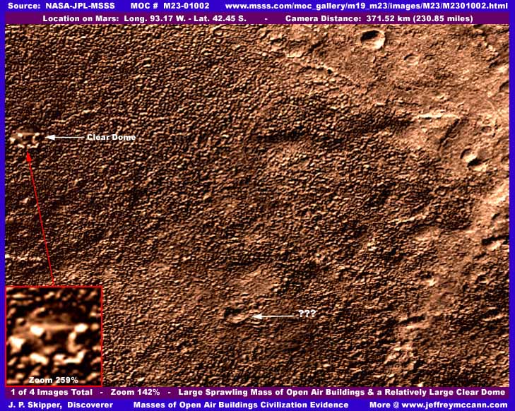
In my opinion, the small detail very knobby terrain you are looking at in this second image here is not terrain geology at all as it is designed to appear but thick densely massed buildings at the limit of camera resolution. Unfortunately, the distance in this shot is too great and the detail far too tiny to really see any detail of individual structures to confirm this conjecture. I can tell you that the closer you get to this scene, the more blurry everything gets of course but also the more each knob begins to resolve into a regular geometric form rather than random rounded terrain detail. At least we can see a relatively large dome (small here only because of the 230 mile–371 km distance from the camera) on the left edge of the image that the tampering software missed.
Further, in my opinion, what appears to be regular slightly smoother terrain in the upper right corner of the image is actually a fine flattened smudging application done in much higher resolution images than these images released to the public. It is designed to artfully and creatively blend in the tops of these knobby appearing structures and create a smoother and lighter colored but harder looking surface terrain while still retaining a little ground mimicking detail rather than looking too smooth an artificial. In other words, it is designed to make the whole look more like variations of natural geology. It is skillfully done and very effective.
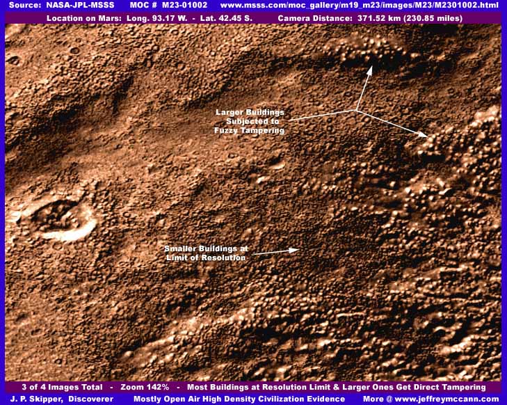
The third image above has no clear domes to tip us off and help encourage easier identification of suspicious civilization evidence but there are larger building clusters here as well as tiny ones. The larger ones have been dealt with by mixing blurry, fuzzy, fog tampering around their base and sides and in the inter-spaces between buildings and completely over the tiny buildings while leaving the larger building tops exposed but covered with a clear brightened blur that effectively rounds them slightly because of the radiating outward glow off of the building tops. This mimics the knobby rocky boulder terrain look even though the fuzzy fog tampering is a little more obvious. This kind of minute level tampering with these larger buildings could not be done by hand and not even by computer software alone in my opinion unless the computer was operating with original images that were providing a much closer view and much higher detail than we are seeing here. If it wasn't for the obvious blurred fuzzy areas, this illusion of ground detail would be perfect. As it is, it is still very effective in creating a natural ground terrain illusion.
Key to the tampering's success is doing this in much higher resolution images where the objects are much larger and clearer. After the tampering application is done on the larger building clusters, the camera distance is simply increased until the structures become smaller and vague and run together into a indistinct collective masses that look like this knobby terrain detail. This blurs the larger structures and runs the smaller structures into a indistinct mass. It is this kind of combined tampering evidence using application techniques and positioning objects at the limit of resolution in the MOC imaging that convinces me that those doing this are in possession of much higher detail camera work than is being admitted to or being released for either scholarly or public consumption.
This is what happens when publicly funded science data is filtered through a system controlled by military/intelligence acting under the guise of National Security without any public input or checks and balances of any effective kind. We want your money but we'll decide for you 100% what you need to know and when you need to know it, if anything and if ever. That super spook Admiral chairing the JPL oversight committee will see to it for us all. In my opinion, keeping the public in complete ignorance as to what is really on Mars and the science community in a fog of blind paradigm conditioning is doing this country no service and playing with fire of explosive proportions. But, you must decide for yourself how much you want to know and how you wish to be treated by those that are suppose to be serving your interests.
Also along the image tampering line in this particular image strip, although this strip appears to have the right orientation relative to its companion M23-01003 wide-angle image and does not appear to be flipped, someone has messed with this strip as a whole fairly significantly before releasing it to the public. Although my images show only a couple of insignificant craters as seen in the first and third images here, there are a number of larger size craters in this strip and every single one is not just elliptical but pretty severely elliptical and that normally means big time artificially introduced distortion. Since I don't have the true original to compare with, I am uncertain as to the degree to which this distortion has impacted this strip's anomalies but I thought you should at least be aware of it and the fact that it is not me who has done this.
Another point that I would like to make is that I would like for you to compare the knobby "terrain" you see in my second image here with the third image in my previous report HERE from the M07-03338 strip titled "Forest of Life on Mars." There you will find a very similar knobby terrain providing a slightly clearer (although no closer) view without the heavy application type tampering that I have described here in this strip and report but of course with the manipulation of distance viewing resolution type tampering. In that earlier report, I expressed suspicion that the knobby terrain look there may represent building civilization evidence. Now, after examining similar tampered with knobby terrain evidence here in this report, I am even more suspicious.
A final observation is the size of the image files involved here in this report. As in the older M07-03338 report and its third image, the file size on these images here are a whole lot higher than a typical image and even higher than in M07-03338. I am sorry but there is little that I can do about this and the space hogging slow loading that it will cause. I have reduced the file size as low as I dare go without loosing excessive detail and still the image file sizes are very high. From my experience with the Mars imaging, I interpret this as PhotoShop seeing a lot more detail in these images than the eye can see here. I strongly suspect the software is seeing all of the original hidden detail in the image at mathematical algorithm level plus the tampering detail on top of that. As far as I am concerned, this is yet more evidence of the high level of tampering in this strip just as it was in the M07-03338 strip and demonstrates just how hard it is to develop a perfect tampering scheme that doesn't leave some evidence of itself behind.
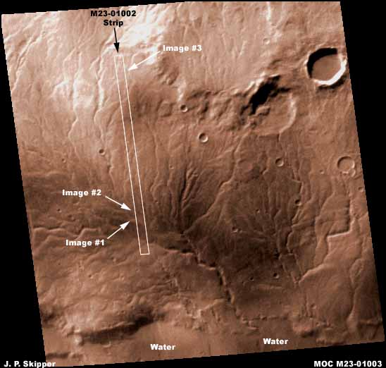
I've included the above companion M23-01003 wide-angle image here to demonstrate the type of terrain the discoveries in this M23-01002 strip and in the previously reported on M19-00070 strip are located in. In this wide view image you can clearly see this old giant water drain system with its many tributaries across the land surface finally merging into a single large deep cut river system. A couple of smaller secondary systems can be seen off to the right. Note what appears to be a distinct ragged shore waterline indicating that there may well be water in it. Note that the water drain systems all terminate right at this visual waterline as they would if water was present. Another good indicator of water. I did not report on this in the prior M19-00070 based report but decided that this was another reason to report on this M23-01002 strip besides just the domes and the more ambiguous open air massed buildings evidence.
DOCUMENTATION
http://www.msss.com/moc_gallery/m19_m23/images/M23/M2301002.html: This evidence is drawn from NASA/JPL/MSSS's official MOC M23-01002 original strip and the companion M23-01003 wide-angle strip is of course found there as well. My data was extracted from the third listed, best quality, slower loading, not map-projected strip but the second listed, medium quality, faster loading, not map-projected strip works just as well for checking behind me. Just realize that the size of the objects in question here will differ. For example, the low profile domes can be confirmed, although on a smaller scale, in the gif and jpeg strips but the clear dome will be too small and the open air massed buildings just can not be seen well enough at all and graphics software will be needed to zoom in on any of these objects. Even so, looking at these images at 100% is worthwhile to compare with what you see here so that you can see just how thoroughly effective the tampering is on the smaller 100% more normal scale in the official images that most will being see them at. The first listed tiled image is inadequate for any anomaly viewing. The companion M23-01003 wide-angle image is basically just as you see it here and just as useful at either location. I have not accessed this material at any place other than MSSS and can not comment on what may or may not be available at say PDS or USGS. Good Luck.
, Investigator
![]()