
UNDERSEA MYSTERY-4
Report 226
November 7, 2012
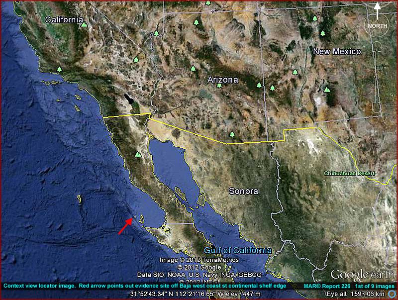
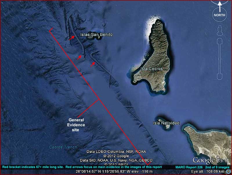
The above 1st
and 2nd images are wide-angle locator type images
that should help those of you around the world who wish to get on Google Earth
and examine the evidence in this report for yourselves. As you can see in
the above images, the evidence here is in a narrow strip running along where
the continental shelf drops off into the Pacific deep. Note that it reveals
partial sea floor details extending north to south down the Baja peninsula
west-coast right on the edge of the continental shelf where it drops off.
The most obvious evidence that doesn't fit the more natural looking terrain
and draws one's attention is what at first appears to be exposed ridge lines,
tubes, or tunnels that I've pointed out with red arrows.
The truth is that this anomalous looking evidence here is in relatively close
proximity to what I have identified as a destroyed mine in my separate Report
225. In fact, the two sites are so close to each other that those
doing their own research on the Report 225 evidence will more than likely
quickly encounter this Report 226 evidence and be inquiring about it as well
as being compelled to report on it themselves. Therefore, anticipating this,
I am making this second Report 226 and releasing it at the same time as Report
225 to reveal the most unusual aspects about this particular evidence to at
least make sure that it isn't missed.
Report 225 is for the most part evidence with my speculation that the main
object in that report is a gigantic mine destroyed and immobilized on the
sea floor due to catastrophic destruction all along its left or west side.
I speculate that the destruction was likely triggered by the immense mine
crossing over harming and revealing a system of tunnels or tubes and someone
associated with them no doubt objected to this. On the other hand, in a different
scenario the mine could have also simply been a run-away and it had to be
stopped fast in its tracks. However, we'll likely never know the answer to
that via this Google Earth evidence.
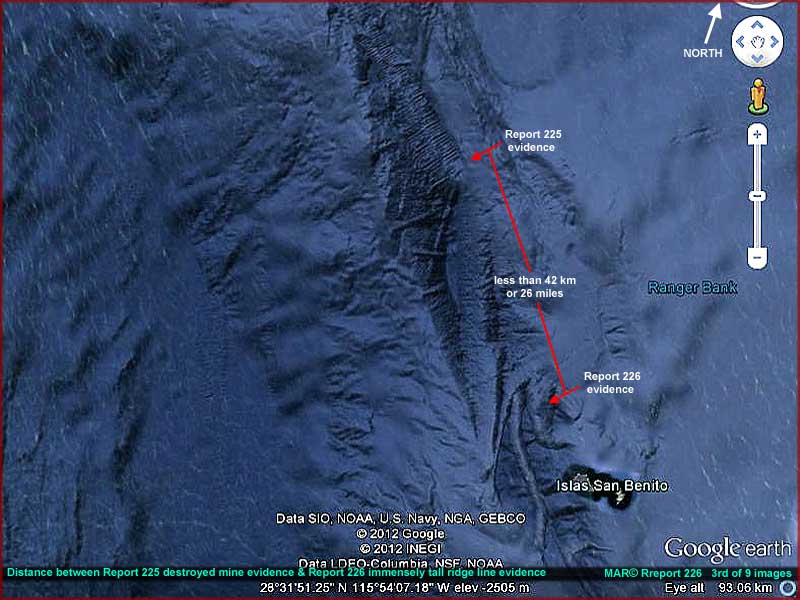
In the above 3rd image you can see the fairly close proximity of the two Report 225 and Report 226 evidence sites to each other. If any of the scenarios I'm speculating on here are true, the destroyed mine's original path, assuming a south to north course, would have probably carried it right into the thick of what is almost certainly civilization evidence in this report. Evidence that is every bit as large or larger than the mine's immense size and with incredible vertical heights that very well might have destroyed the mine and anyone onboard along with severe damage to some colossal tall structures. So stopping the mine fast may have been a priority benevolent decision and we should not assume it to be a hostile act until more is known.
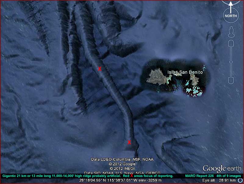
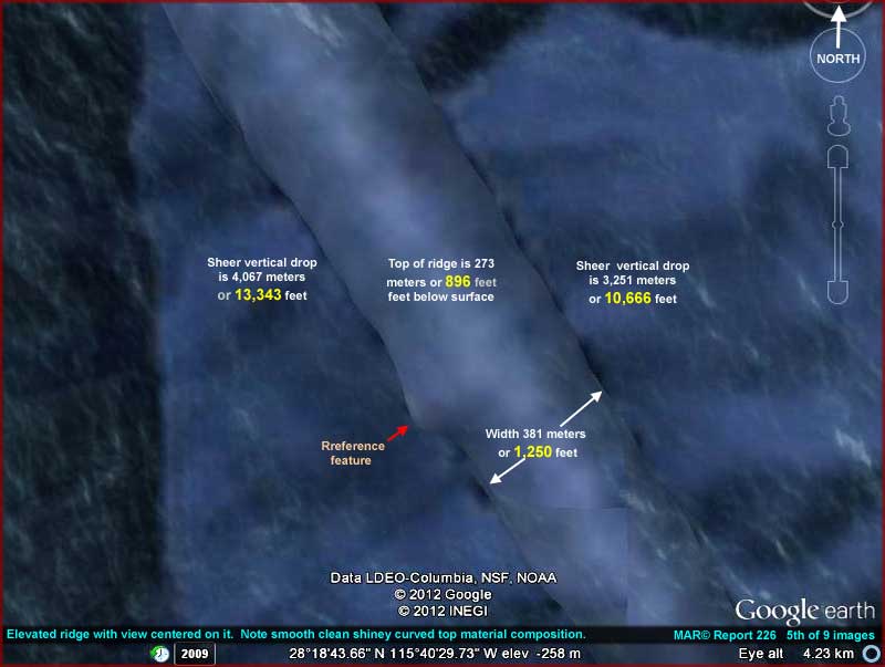
The above 4th image
demonstrates the evidence site that is the main subject of this report. It
consists of a series of what at first appear to be ridge lines and the "ridge
line" with the two red X's on it is the
most obvious. However, once this object is examined more closely, it begins
to suggest what could be tubes or tunnels as in Report 225 but then even closer
inspection reveals more than that and more than what one would expect.
Even at the distant view provided here this 21 km or 13 mile long "ridge"
looks strange and anomalous like a tube or tunnel where it shouldn't be but
closer inspection reveals anomalous information more and more suggesting artificiality
that goes beyond mere tunnels. For example, the entire ridge line is a consistent
1,250 feet in minimum width along its 13 mile long length. Further, its entire
top surface is consistently rounded or dome shaped as well as smooth and clean
as though it is made of a smooth glass like material and this extends down
its sides to the bottom some 10,000–13,000 feet below and it appears
to be well maintained to remain clean.
Compare that to Earth's tallest building which is the 828 meter 2,716 foot
tall Burj Khalifa tower in Dubai. Also, despite a sort of natural look mimicking
a ridge line its top surface is a consistently level 273 meters or 896 feet
deep below the ocean water surface. Even though that's just the beginning,
note that at depths below 500' it is dark as the inside of a cave with no
sunlight penetration at all and the pressure is absolutely tremendous to the
point of being very dangerous to we humans even when we're surrounded by armour.
Likewise and get this, if you fell off the top side edge of this structure
even armored to withstand the monstrous pressure, you would be in a unimpeded
free fall with plenty of time to think about it straight down the sheer vertical
smooth walls about 10,000+–13,000+ feet to the bottom as confirmed
by the many depth counter samplings I've taken in Google Earth to make
sure as sure as possible that this evidence is real. Also, examination of
the object's sides and their base areas does not reveal any unique supports,
just a smooth straight drop down to the bottom.
So, except for being anchored on the bottom and at each end, this monster
narrow immensely tall construct is a free standing object of sorts. Considering
that this 13 mile long object sits on an area of likely geologically unstable
ground faults where quakes are fairly common, its survival there over time
is an extraordinary achievement by "someone."
All in all to say that this 13 mile long, 1,250 foot thick, 10,000–13,000+
foot high, but still relatively level object is enormous as well as anomalous
and an attention getter is a serious understatement. It appears to be an artificial
construct of immense proportions fully equal to or far exceeding the immense
"mines" or "mining" scale concepts.
Remember and I repeat, the top of this object starts almost 900 feet down
below the ocean water surface. At that depth arriving that at the top of this
object it is black dark when it comes to known human vision limitations. Likewise,
the starting pressure just at the top of this monster object, as tremendous
as it is, is nothing in comparison to what would be the case further down
into the 10,000–13,000+ feet depths below where its base is and where
construction without a doubt must have began on it whenever that was started.
Also, remember that we are provided only a partial look at this type of huge
scale evidence while other likely even more significant evidence is still
hidden from our view no doubt by intent. Remember to that the only people
known to us that might be able to reach these depths and only for a few minutes
at a time must less work down there for extended periods of time building
this construct are what I refer to as Earth's secrecy crowd. Note that it
would be most uncharacteristic for people of their psychology to reveal this
evidence if they had a choice.
That means that this evidence, assuming it is real, almost certainly belongs
to someone else that isn't us and also is not the secrecy crowd. What we can
see of this is just what someone wants us to see. Likewise, that in turn means
that our secrecy crowd, unless you can believe that they don't know about
this sitting in plain sight in Google Earth at the coordinates provided in
the images here, is logically unable to prevent its display. In my opinion
and after years of dealing with them through this work, our secrecy crowd
would never allow us to see this if they had the power to stop it. That logically
suggests that who ever this is has the power to make their things happen the
way they want them to and over the anticipated resistance of our secrecy crowd.
I need to also say that this construct's presence on the sea floor some 11,000–14,000
down and in the black dark and under monstrous pressure along with the mine
activity that is present around our planet at these same great depths suggests
that who ever this is may be quite comfortable with those depths, darkness,
and pressure further identifying them as not us and likely possessing technology
well in advance of our own.
The above 5th image demonstrates a closer view of a representative upper section of the 1st object in question. The view is centered right on the top of the main formation. The narrow darkness just visible shown on either side of it are actually the base areas of the object where they are in contact with the bottom thousands of feet further down below. This demonstrates just what a steep vertically straight down free fall drop it is. Note that the top of this free standing formation, although some 1,250 feet across at this most narrow point, is rounded, smooth, fairly level, and appears to be covered in some resin like sealing material.
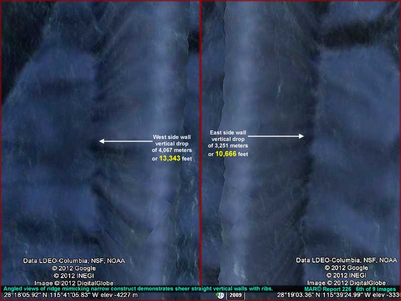
The above 6th image
is a split screen demonstrating two angled views of the formation's side walls
first on the left/west side and second on the opposite right/east side. The
right or east side is normally a bit less in depth than the left or west side.
That is likely because the right side is normally associated with the proximity
of the continental shelf's adjacent more shallow depths and that may generate
more sediment drift over time.
As you can see, either side appears to be vertically smooth and straight down
from the top to the bottom without a break in it or any evidence of extra
supports. These do not appear to be image artifacts and therefore not real
because I can confirm that the whole 13 mile length of the formation responds
as something real to the Google Earth depth counter and is like this. On the
other hand, the sides do show some visual slight bulging unevenness from bottom
to top and with some regularity.
This suggests that there may be massive ribs inside the formation sort of
like the substantial vertical sections of a free standing oil space heater
or radiator design if it were covered in resin. However, speculation of the
presence of such ribs as described here are via simple observation and cannot
necessarily be relied upon as fact without being able to clearly see them
through the exterior surface and someone who dots all the "I's"
and crosses all the "T's" on this evidence is obviously preventing
that.
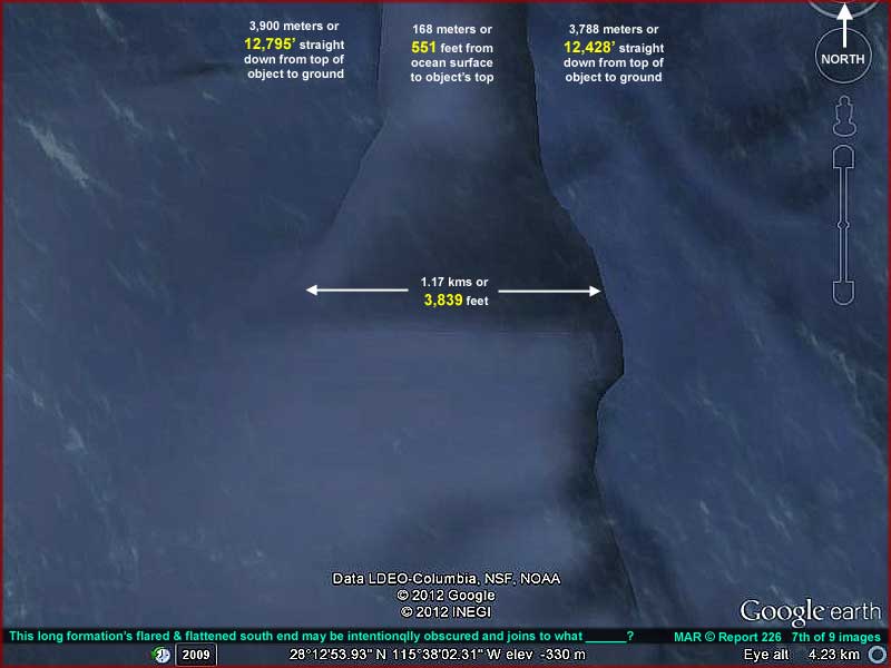
The above 7th image
is all the way down at the south end of the formation where it appears to
terminate and may attach to the land mass there. Although, as you can see
here, the end flares as well as flattens out, it is otherwise obscured on
the left or west side as well as at the very south end top. Considering that
the entire 13 mile length of the formation appears relatively free enough
of image tampering that might conceal it as an artificial construct and its
purpose. I strongly suspect that researchers in Google Earth like myself were
meant to find the clearer narrow strip portions of this evidence but apparently
not all of it.
That combination of revealing while at the same time hiding some aspects suggests
manipulation and, as I stated above, I do not believe that the regular secrecy
crowd I'm so used to dealing with would have done this. In my experience,
they've always been consistent in their attempts to obscure and hide all that
they can that may lead to knowlege or civilization evidence. I do not believe
that they would have left any of this for you and I to see if they had a choice.
I suspect that someone not us has technology here that brushes our secrecy
crowd's efforts aside and shows what ever they want to and hides what ever
they want to. In other words, I suspect that someone unknown to you and I
is giving us the opportunity to look at this in a limited way to recognize
it as both artificial and massive but no more than that, at least for the
time being.
I suspect that the nearby destroyed mine in Report
225 is the same situation and contiguous to this Report 226 evidence
even though I have treated them separately. It is a strong reason why I draw
a connection between the Report 225 mine destruction and these Report 226
formations rather than promote the concept of some kind of internal mine defect
and failure. The fact that the mine continues to sit there apparently unattended
and for all to see by either the mine operators or the local types or even
hidden by our usual secrecy crowd says a great deal to someone suspicious.
Why be suspicious you say? Well you don't see anyone else but a lone independent
bringing this kind of evidence to your attention for your consideration do
you? The question should really be why aren't others more suspicious or are
you interested in the truth?
So what is it that no one want us to see by limiting what we can detect here?
I suspect that they don't want us to see ships (USO's) or their support facilities
because I do suspect this flared end is an entrance to the main complex and
much might be reverse engineered by a detailed look at very much of that not
to mention that the area may still be life active. On the other hand, I of
course might also be reading too much into this but I can't escape the sense
that someone is controlling the perception here in what we're allowed to learn
from this discovery beyond the probable reality of someone else's existence
on this planet with us and what they may possess and be capable of.
I realize that this kind of speculation will be upsetting to some and result
in plenty of criticism headed my way with respect to what they will characterize
as my wild imagination. However, I think that I would be remiss if I did not
reveal all the insight that I think that I can on this. Someone wants us to
see this destroyed mine in Report 225 and of course be impressed by it. Further,
I suspect someone also wants us to see the massive size scales involved in
the colossal constructs. Why? Perhaps to teach us to use restraint and be
more careful and cautious. You may see it differently but that's my take on
it.
In case you might still contemplate that the "someone" is in our
usual human secrecy crowd, consider this. Remember again that down where all
of this evidence is at it is black dark for we humans like being inside a
cave with no sunlight penetration at all and the monstrous pressure being
exerted down there precludes any real working at these depths under our current
technology. Further, the artificial constructs we are allowed to get a decent
look at here are not only massive, they are in a likely geologically unstable
area where they must survive earthquakes over time.
So they can be considered permanent massive constructs that would almost certainly
take time to build with that process extending back in time. That logically
means that it is extremely unlikely that humans with our limitations had anything
to do with building them within our known history. Further, what appears to
be the cleanliness of the primary constructs undersea and no one attempting
to hide the damaged mine suggests that at least some level of life activity
by someone may continue at these sites actively rendering decisions along
these lines.
If so, that is a concept that some may find disturbing. I've found that ancient
long abandoned evidence in the relative sense is more acceptable with the
mainstream than the current presence of a strong civilization here that isn't
ours. This evidence so close to us just isn't something that the mainstream
prefers to be aware of. Further, it is even more disturbing if that evidence
is thought to be right here with us on Earth rather than off on some distant
planet.
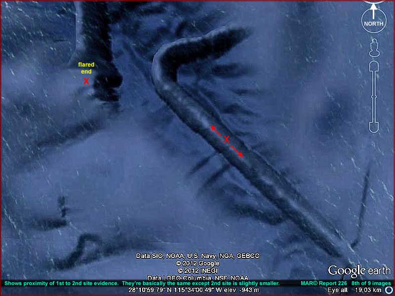
The above 8th image along
with the 2nd image further up demonstrates where this report's 1st and 2nd
sites are located in relation to each other. Note that the secondary object
under focus here in this report with the red "X"
and red arrows may have been disconnected from the flared end of the 1st site
evidence at some point in the past and then bent in a curve to run north and
south parallel along the edge of the continental shelf to form a shield wall
there and of more modest proportions. Unfortunately, although there are other
such constructs bisecting this terrain that I'm not reporting on here, note
that we are not privileged to see how or if this kind of evidence may form
joint networked systems with each other and otherwise determine what is really
going on here.
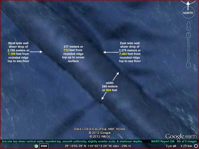
The above 9th image except for measurements as
in the 8th image has the main emphasis on the object marked with the red "X."
Note that the evidence in this 2nd site is essentially the same as in the
1st site except the scale sizes of the objects we can see are somewhat less
and the water depths are little more shallow. Otherwise, the construct designs
are the same. So there doesn't seem to be a reason to produce another series
of images for this evidence here.
In this report's imaging, you will see the close proximity of the Islas
San Bernito only about 3.5 km or 2.17 miles from the evidence site.
This is a relatively bare uninhabited small group of three islands about 100-110
km or 62–68 miles off the west coast of the Mexican state of Baja California
right where the continental shelf drops off into much deeper water just west
beyond the islands. Another nearby much larger more populated island is Islas
Cedros about 25 km or 15 miles to the southeast of San Bernito. About
15 km or 9.3 miles to the south of Cedros is the more
modern Islas Natividad focusing more on tourism. A primary attraction
in all these areas is fisheries, birds, seals, whales, kelp, salt, etc. and
a bit of tourism.
The 150 km or 93 miles of island north/south distances combined together parallel
the length of what we can see of this evidence site. Most of the evidence
is hidden behind obfuscation treatments but a very narrow north to south band
or gap in the smudge reveals at least what I'm reporting on here. Of course
there may be more and even a lot more but this is all that can be ascertained
at this time. Obviously, out of 93 miles my reporting can only focus on select
representative samples of the evidence and I've tried to select the most informative
in these two reports.
As I write this my thoughts keeps returning to my Commentary
#054 on "The Bloop" sound and the possibility of the existence
of Merpeople. If Merpeople do exist then the general "assumption"
is that they may be an ancient race that evolved from scratch on this world
via a different path and have managed to successfully avoid humans because
they are a race now of few survivors with only primitive technology like spears
and arrows. This is a less disturbing view to some because it is perceived
as safer by the mainstream but it is an assumption based on ....... well nothing.
The Earth is at least a 70% water world with we humans occupying only 20%–30%
of the dry land space sticking out of the water and that logically may even
exclude the entire large continent of Antarctica allegedly covered by snow
and ice. I'm also still thinking about those cave paintings shown in that
relatively crappy Mermaid TV special that in my opinion was meant to undermine
itself. If those cave wall images are for real, they may possibly date back
into prehistoric times and they depict Merpeople swimming with or cavorting
with people, whales, dolphins, etc. suggesting that some early humans did
know of their presence.
However, what if Merpeople do exist here on this 70% water world and what
if they are connected to the massive constructs depicted here in this report
or perhaps to the 5-mile wide undersea mines? If so, that means that they
logically are also connected to the advanced technology that it took to build
the mines and/or the colossal constructs. Now that we think a little more
about it, they aren't perceived as being quite so safe any more are they?
Remember that who ever did or is doing this is operating in what to us is
complete darkness building and navigating massive undersea mines in that darkness
and/or building massive undersea free standing colossal constructs starting
at 14,000+ foot down in our ocean's crushing pressures. Further, they likely
started this back when avoiding humans was not likely an issue and operating
in this darkness at these depths was likely only a matter of their own convenience
unless there were other enemies of that time for them to consider. If there
were enemies of that time for such people to consider, obviously you and I
would not like to meet them.
It's all just speculation but it also isn't something to just dismiss wholesale
either. The bottom line is that evidence like this appears to be mounting
and moving us toward an awareness of our not being alone on this planet. Therefore,
we need to be paying attention to it, not try to leave it to others hoping
they will deal with it for us, and not just automatically dismiss it. Remember,
although my interpretation can be as off the mark as anyone's can, I do not
make the evidence, only report it.
, Investigator
![]()