
UNDERSEA MYSTERY-3
Report 225
November 7, 2012
This report follows up on essentially the
same type of subject matter in my last Report
224 of undersea surface mining at great ocean depths here on Earth as
viewed in Google Earth. In that previous report, the evidence examined was
in the form of immense mine tracks some 5-miles wide with the best of them
on the sea floor in the ultra deep water of the Pacific Ocean's Mariana Trench
system near the island of Saipan extending some 388 miles distant along the
top of a very deep undersea ridge in that area.
Note that this report is actually the first of a pair of reports released
at the same time that includes Report 226. You
will want to make sure that you explore both reports to get a a sense of the
larger picture that may include new civilization evidence.
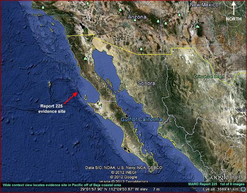
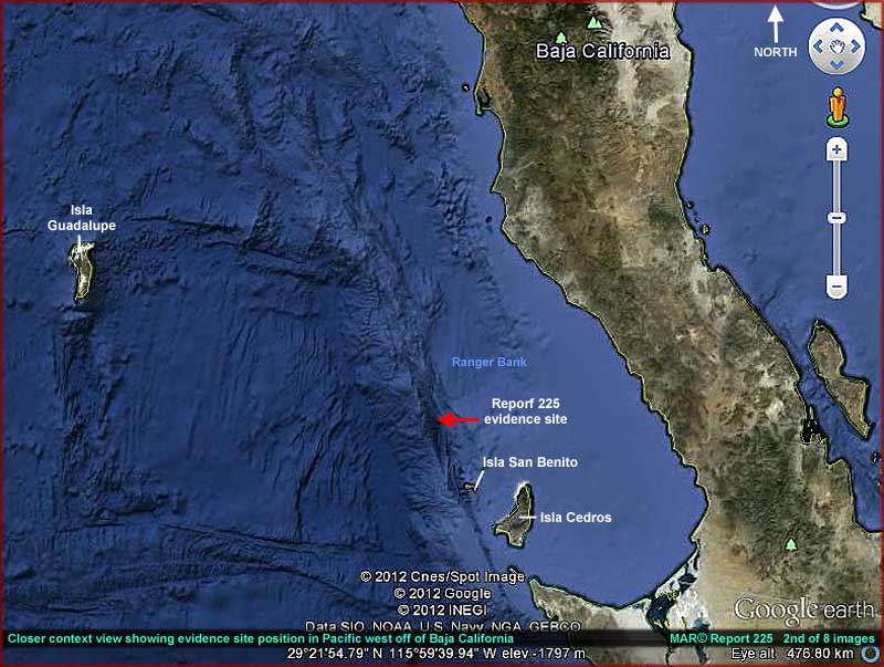
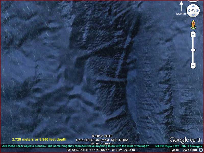
Meanwhile, in this report what we're going to take another look at is very
possibly one of the mines that made such tracks. It is disabled and located
in the 8,000+ feet deep off the west coast of Mexican Baja California on the
edge of the continental shelf where it drops off into the Pacific deep. The
above 1st and 2nd images, the red arrows, and
the coordinates provided with the report images should assist those of you
interested in looking at this evidence for yourself in Google Earth to verify
it.
Now I am aware that some would have you believe that what I identify as undersea
mining evidence is actually the result of flawed ship sonar readings presenting
false reflections as they make their surveys and that it is therefore not
real. Sorry but I just can't buy into that not even a little bit. The fact
is that the behavior of the evidence in my last Report 224 is just too complex
and too typical of heavy equipment crawler activity on the ground for me to
have any confidence at all in such explanations.
The truth is that I anticipated just such an explanation first because I suspect
it serves someone's secrecy agenda having been used before following my 2010
and second because it sounds safer and more comfortable for
the mainstream public to grasp as an extension of their own nervous reservations
to face and deal with this kind of material. So be forewarned that my Google
Earth reporting will continue until and if someone can convince me otherwise.
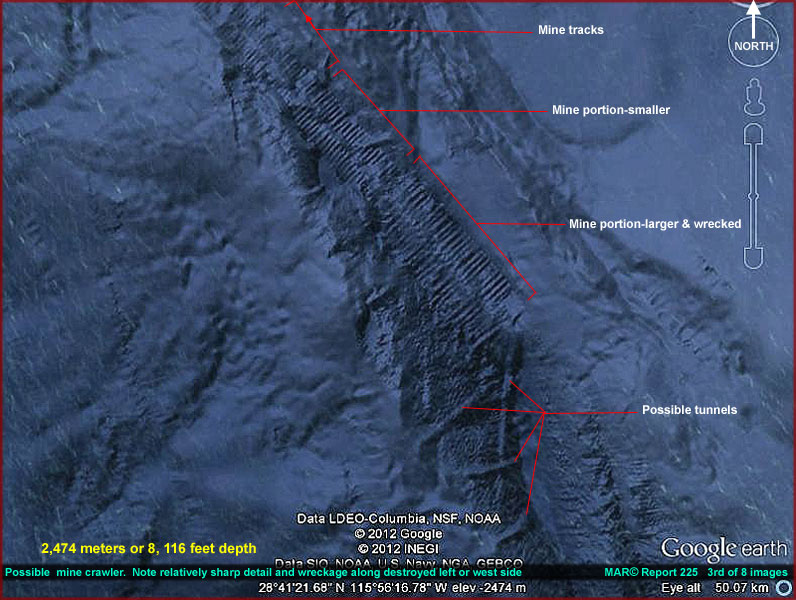
The above 3rd and 4th
images provide a closer context view of the mine evidence site. One
of the first things you'll notice in these images is the elongated linear
form extending from lower right to upper left which has many equally spaced
plates or vanes all along its entire length. In my previous reporting I speculated
on what design I thought the mines might consist of but, if this is a mine
as it appears to be, then it is different than my speculation and it appears
that I was wrong in that regard.
If this is an object rather than a track on the ground as I strongly suspect
it is, it appears that these mines are a long linear line of likely articulating
parallel equally spaced vanes or plates. Note that at least a third of the
mine's length toward the upper left in the above imaging appears to be a bit
smaller size relative to the larger size main portion of the mine to the lower
right. This smaller section may be an extension of the original mine or it
could be a second smaller mine pressed into service to try and move the larger
mine and got stuck in the process.
This line of thought and speculation seems valid to me because the mine's
degree of damage may not have been visible at the time an attempt was made
to move it and they may not have had an accurate assessment of how extensive
the damage was. However, if the smaller mine is but a part of a larger whole,
I'm going to conversely speculate that the larger portion of the mine to the
lower right in the image is the trailing part and the smaller portion to the
upper left in the image is where the leading end was located when the mine
was under way. Of course one can't know any of this for sure but I believe
these scenarios are fairly logical and the most likely speculation.
Note that this is definitely a disabled and immobilized mine and that is likely
a major reason why it continues to sit there for you and I to see rather than
being removed or at least hidden from view by someone's image tampering talents.
If you will look closely you will see catastrophic disintegration damage all
along the larger mine's main left side that is not present on the mine's opposite
right side nor is it present on either side of the mine's smaller section.
So what happened? The visuals don't tell us enough to be certain of that but
I suspect that the mine in its forward motion was crossing someone else's
buried hidden territory triggering some protective devise automated or under
intelligent control associated with what appears might be visible tunnels
pointed out by my labeling in the 3rd and 5th images here. What ever force
this was that blew against the immense mine's left side skidded the whole
of the large vehicle sideways to its (our) right and partially out of the
mine's original path.
I speculate on such a scenario here because note that no one seems to have
invested any successful effort to salvage the mine or cover over the possible
civilization evidence it may have partially revealed. That may be because
at the time both sides, if there were sides and any survivors, had a fear
of exposing themselves to retaliation and more destruction resulting in a
stalemate and coming to having to eventually live with that compromise.
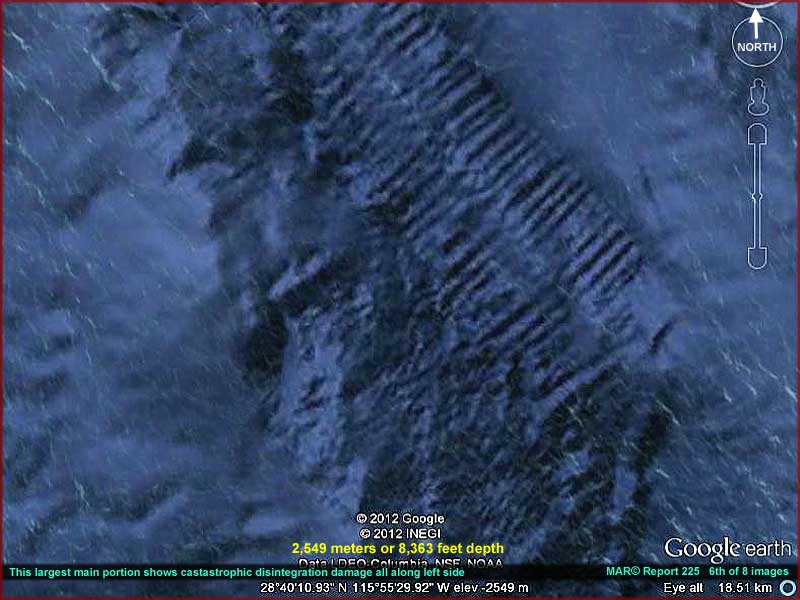
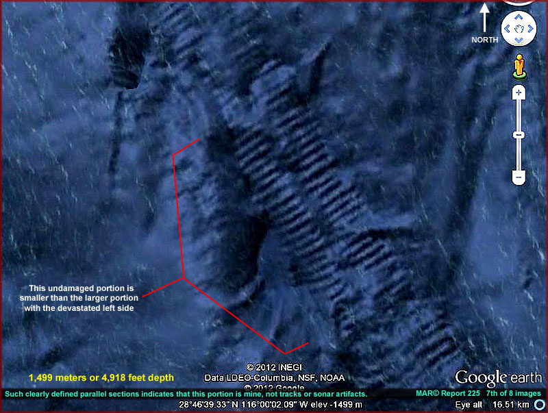
The above 5th, 6th
and 7th images provide closer views of the evidence site. All of this
evidence seems to be partially buried down in a depressed area and what we
are seeing is only the tops of the objects under consideration here even though
bare of sediment covering. The many vaned primary object with the devastated
left side is almost certainly a mine and it is leaving the very similar kind
of tracks signature brought to your attention in Report 224. However, here
it is deflected or pushed sideways partially out of its original path by what
ever weapon destroyed its left side.
As you can see, even after the lapse of time and the
effects of poor image resolution, the evidence is still very well defined
except for the smaller debris in the catastrophic damage side areas. That
level of definition is mostly due to the immense size of this monster mine
and the fact that its many parallel vanes are so equally spaced, so rigidly
organized, and so rich with detail compared to its natural more irregular
surroundings.
For example, the definition is good enough to tell us that each of the individual
vanes have rounded uniform corners as opposed to sharp 90º right-angle
corners to help the mine navigate partially buried through the softer sea
floor bottom sediment it might encounter. Note that the vanes width also have
a depression in their center consistent with what can be seen of the mine
tracks in Report
224 both here and there telling us that the half of the vanes on one side
are independent of the half on the opposite side. This is especially evident
when the mine makes 90º or tighter angle turns. This kind of strong detail
would not be the case if these were false sonar imaging artifacts and not
real as some may likely try to claim.
I must say that I was a bit surprised at the design of this mine as it is
not as I envisioned in Report 224. If the mine is not turned over with its
bottom pointing upward here, and I don't think that is the case, it appears
possible that it travels over as well as deeper through sea floor terrain
via its articulating vanes sort of like a snake travels over ground via manipulating
its internal ribs and scales. I'm no engineer but I wonder if it may be possible
that the many flattened vane articulating surfaces working together as a system
may help spread the pressure at these extreme depths over the entire machine?
This suggests that mines like this behave more like remote controlled "crawlers"
across sea floors than anything else as the many articulating vanes pinch
and grip the sea floor leaving behind their tell tale imprint on the ground.
Meanwhile, the design here of this mine clearly matches some of the mine tracks
identified in Report 224 reinforcing the mining operation interpretation presented
there and tending to negate arguments by so called "experts" that
what has been identified as mine tracks are nothing more than ship sonar falsely
generated artifacts and therefore not real information on the ground.
Of course, in one of the scenarios I've speculated on here, it is possible
that the smaller section was not originally part of this mine but another
mine coming in end to end from the north to make a try at salvage only to
bury deeper becoming stuck and then left abandoned looking to us like part
of the original larger mine. Likewise, the larger mine's destruction may have
not been an act out of conflict violence at all but merely a way for members
of the same community to disable a large out of control mine fast before more
damage to hidden facilities could become much worse.
In other words, we may not be looking at two sides in conflict with each other
here but at only one side trying to limit a disaster to one of its communities
due to operator error mistakes and/or equipment failure. Note that we're allowed
to see this mine and only a little of what it encountered but that information
is too limited and too many assumptions could develop an assessment too far
off the mark. My advise is to be sure to examine the next Report
226 before forming opinions in this regard.
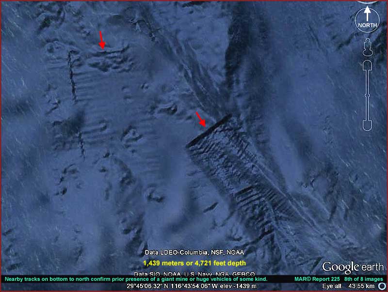
The above 8th image site is nearby north
of the main evidence reported on here. I've included it here because it is
relatively close to the main evidence site and merely convenient for this
purpose. It shows terminating mine tracks that are so obviously on the sea
floor and therefore hard to confuse with any kind of sonar false imaging artifacts.
I've included this evidence here as just another nail in the coffin of any
potential argument from "experts" should they be trotted out trying
to convince us that none of this is real and just for example false sonar
drag readings.
On the other hand, let me make it clear that no one, not myself or any one
else including so called "experts" can guarantee with absolute certainty
what we are all looking at here in this report and the previous one. You'll
note that there is some significant speculation involved here. I like to think
that my speculation is based primarily on objective logic and reason extrapolated
only from the observed evidence presented where I'm afraid that others are
too often not objective and respond based more on feelings of what they regard
as possible or impossible in their training and depending more on their social
consensus approval as being well trained and therefore credible "experts"
than any real reasoning process.
You must use your own questioning and reasoning to determine where you believe
the truth may be. Is a well meaning but clueless boob following his
own prejudices rather than the evidence or are too many highly trained "experts"
following their deeply training ingrained prejudices that perhaps even unknowingly
also incorporate the hidden agendas of others?
One thing is for sure, the next time you watch a TV program discussing the
ancients and it is talking with amusing tones about the "mythology"
of Zeus, Apollo, Thor, etc. or even Nibiru and the Anunnaki, this"mining"
evidence and its implications is likely going to creep into your private thoughts
and also become part of your consideration lending a level of seriousness
that you may not have had before when you were inclined to automatically without
much thought dismiss it all as ridiculous. That is as it should be.
, Investigator
![]()