
GROUPS OF TALL
GEOMETRIC STRUCTURES
Report 063
March 12, 2004
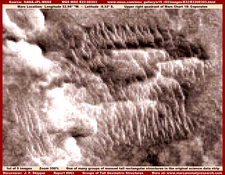
The above image is the first of five in this report. All five are similar representative samples of groups of many massed tall rectangular geometric structures identified in organized patterns as revealed in spots all over the original E22-00303 science data strip. The strip is full of this kind of evidence and the imaging in this report is only a small part of it.
Likewise, this strip, as one might expect considering the presence of considerable civilization evidence in it, is also a story of massive amounts of multiple image tampering in the form of the distancing technique, pixelation at official level, general resolution degradation, blur treatments over most everything as well as direct smudge applications to name a few. All civilization evidence seen here is intermingled with this and seen only in spite of it.
One cannot see individual structures here so much as one can see their individual blurred outlines. What is most telling about this evidence is the plainly seen geometric shapes, the differing multiple heights from structure to structure, and the organized parallel rows. Obviously, none of this is typical of natural geology and all are highly suggestive of city buildings and high density advanced civilization evidence. Note that these tall rectangular structures and their uniform patterns are well obscured in the original science data at the provided official 100% resolution and it took zooming in some 350% and a fair amount of clarifying to bring this geometric shape evidence out to the recognizable level you see here.
By now, after investigating thousands upon thousands of these MOC images and seeing this evidence in many images but with most seen too poorly to present to you (I only present what I feel is the more obvious), it is becoming clear to this investigator that high density civilization evidence on Mars, at least in the form missed by the constant image tampering and allowing us a look, is characterized by consistently taking this form of very tall closely packed high rise structures in long parallel lines covering wide areas of the planet's physical terrain.
If these groups of very tall rectangular structures are the high rise buildings that they so appear to be, then this gives us good insight into the true size scale here in this strip. This is one of the purposes of the tampering, to destroy all recognizable natural geological and/or artificial construct detail and substitute its own fake detail blurry tampering forms so that true size scale cannot be readily understood. That way, when they draw back to a very distant view with its accompanying poor resolution and shape merging, as is the case supplied in the official released strip resolution, this often applied tampering technique is not readily apparent. The truth is that these many tall rectangular hard objects are very large and this very large size to some extent is the only reason why we can see them at all through this very poor imaging, even as just blurred outlines.
The more obscured areas where no geometric forms are not as readily recognizable at the very top, right side, bottom and left edges of the above first image is yet more of this civilization evidence but more heavily blurred and with smudge applications so that little is discernible there. The very light color areas (can you see the above giant nose profile outline?) just left of center are groups of large structures that have been obscured by the light color over saturation and direct smudge tampering applications that form the nose profile. Also, my clarification of the rest of the evidence in the darker areas has caused these groups of light color structures to be even more light color over saturated
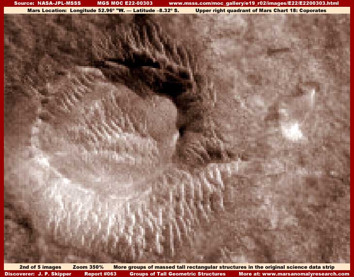
The above second image is another group of these tall rectangular structures in the center and left of center in the image. To the right of center is a large field of image tampering effectively obscuring structures there. This type of tampering is meant to mimic ground detail and is fairly effective at it. But, when you look very close and carefully and/or blow it up larger, there is actually no real identifiable topography detail in this area of the image and that fact provides the tip off that this is tampering application.
When there is a tremendous amount of geometric tall structure evidence all over one of these narrow-angle strips, in the process of covering them up, they also have to leave a little something out of the worst of the image tampering. That is how we wind up with these partially visible groups.
If it wasn't done this way, the entire strip would look blank with insufficient detail (many strips do look this bad) and that amount of broad area sameness would draw attention to the tampering itself if used too much. The automated software maps the strip original details and then makes its applications based on percentages of coverage. They risk leaving a little of the smallest structure detail out of the worst of the tampering from these partially visible groups. The gamble is that no one will look close enough to recognize what is left out for the civilization evidence that it is.
At 350% zoom factor, there is a tiny amount of beginning pixelation introduced into this scene by my own work. However, should any wish to argue that the more identifiable tall rectangular structures center and left evidence is caused by too much zoom creating too much pixelation and these geometric forms, all you have to do is look at the true pixelation in the right field of "nothing" smoother area and compare that directly with the tall rectangular objects in the center and left field in the same image.
Obviously, the true base pixelation introduced into this scene at official level is not creating these tall rectangular hard objects, their uniformity, their multiple heights, or their unique row patterns but working hard trying to obscure it. The bottom line is that these geometric shapes are ground based detail and not imaging artifacts. As further proof for anyone who has the graphic software, just keep zooming in on the evidence beyond what has been done here and you will see the true pixelation as a result of excessive zoom begin to increasingly show itself.
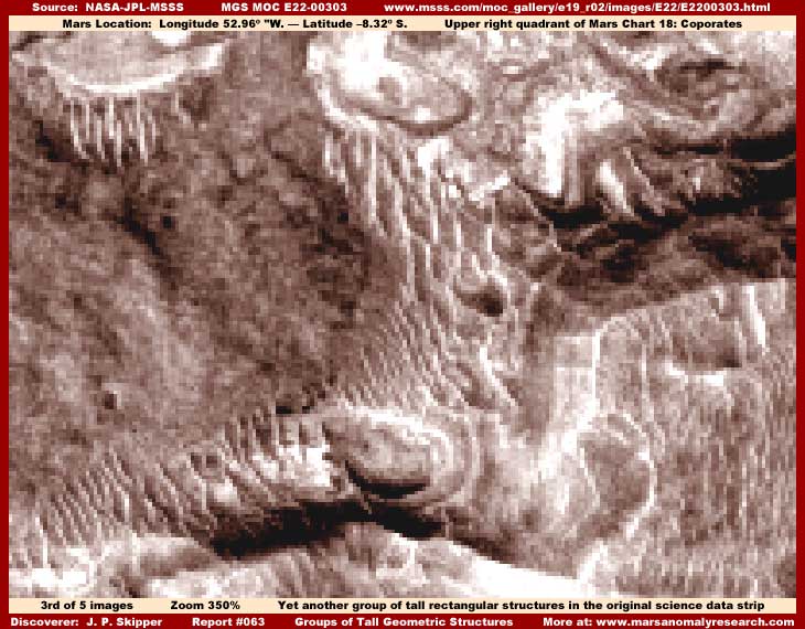
The above third image is of yet another group of tall rectangular structures showing slightly different angles of view. Most of the civilization evidence in this scene has been well obscured by the various effective combinations of image tampering but there is still some spots of tall towering structure evidence left out of it well enough to be seen.
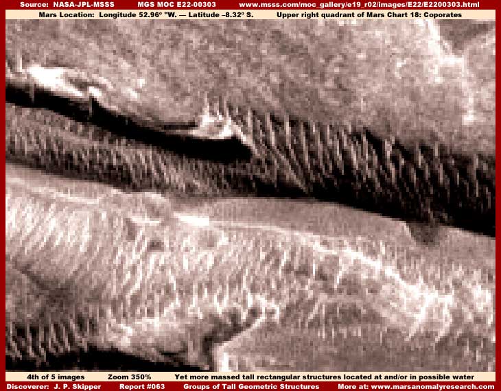
The above fourth image demonstrates the same kind of civilization evidence but here located in depressions and what may be water trough systems. However, the darkest areas cannot be conclusively trusted to be water because they appear to be image tampering applications. The other image tampering combinations are also thicker here in this scene and the evidence is a little smaller sized meaning that the scene is a little more obscured than some of the others but you can still get the idea.
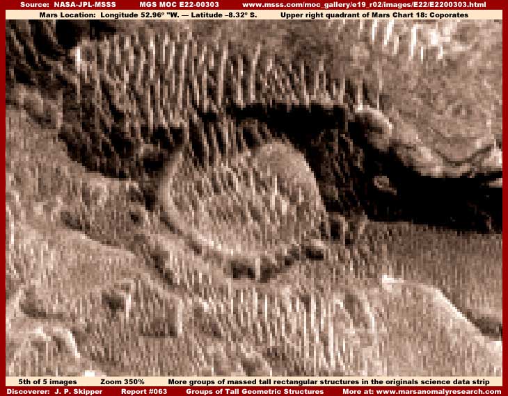
The above fifth image demonstrates several things. The tallest rectangular structures in the top of the image are seen more to a slight side view angle of their normal row orientation and that makes them appear more jumbled and overlapping each other creating visual confusion in that particular group of structures.
The smaller size group of structures in the center of the image with the rounded perimeter is something that I want you to take note of. Specifically the rounded perimeter. This rounded perimeter for a defined group of structures is typical of a lot of Mars high density civilization evidence where it covers very broad regional areas. It is actually a partial ring of light color buildings but with medium color smudge tampering applications strung alone their length to make it appear to be a rounded land form.
This tampering technique is also typical of tampering applications in other sites of high density civilization evidence. Most of the time, this kind of evidence is dealt with fairly severely tampering wise obscuring just about everything including very rapid general resolution degradation that prevents a closer look. I am only able to show this a little better here because this strip did allow a decent amount of zoom (their mistake) before resolution degradation became too severe and my clarification work was also a little more effective here with these tampering applications as well.
The very dark area behind and to the right of the rounded compound is dark image tampering hiding some of the largest tall rectangular structures there, a fair amount larger than other structures in this scene. In this case, the application is dark but often it is medium to light in color depending on what needs to be applied to mimic and create land form illusions. Often this type of wide spread high density evidence will have lines or groups of much taller and more massive structures within the overall evidence.
This is often handled by the tampering just shifting the view orientation so that one is looking down the length of a line where everything blends together. Sometimes flipped views and stretching the image severely distort and hide the evidence. In other cases where the evidence is seen more side view, the smudge applications cover everything but a tiny amount of the top as has been done here creating a land form fake illusion. The visual obfuscation effect is much more effective when seen in the normal poor distant resolution as supplied in the official data as released.
It would appear likely that, where wide spread high density civilization evidence is present, this placement of light color buildings either in long rows spidering out from a central core line or self contained rings seems to be a way of defining compounds or groups of structures and differentiating them from others. This may represent some some form of political, social or religious differentiation or perhaps even some form of advanced technology serving security and/or environmental purposes?
In my my #055 report titled "Towers in the Sun" demonstrating super towers, there is a similar compound effect there formed within and by the structures themselves and my imaging used this spot as a center reference point. However, the total civilization area in that report is otherwise dramatically different in that this is the only place on Mars where I have seen empty space be used to isolate and form structure groups. In other words, there will be a group or pocket of very tall densely packed multiple height structures but then with apparently very smooth level highly reflective empty space (possibly water) all around it and then nearby the next group of structures and so on constituting the great bulk of the total civilization evidence.
In other evidence that I've never presented, this compound approach formed by the tall structures can be all there is with no long running rows of structures at all, only endless density. This civilization evidence will sometimes take the form of many polygons up against each other like cells in a bee hive wax honey comb. The differentiating polygon design light color outline is defined by light colored structures forming the outer ring while darker structures occupy the center area.
The compound design can take yet another form on Mars with a very large area of structures defined with a straight narrow line backbone center ridge of light color structures with many branch lines of light color structures radiating outward in a spider legs visual effect and the inner space between the radiating lines consisting of densely packed darker structures. The overall group in the many hundreds adjacent to each other will all merged into each other's perimeter looking in the always very distant imaging very much like some kind of giant plant roots. Further, this has the appearance of a sea of this "stuff" growing on a broad front with clear terrain just ahead of it. However, very close examination reveals it to be civilization evidence.
However, this unique type of above described evidence really stands out visually strong as highly anomalous and is obviously not easy to confuse with natural topography. Also the usual poor resolution illusion tactics are not that effective with it and only complete blot out or extreme distancing tampering techniques are effective against it, so seeing this in even very distant shots is rare. Usually, if seen at all, the distancing technique taken to the extreme is the obfuscation tool of choice and then the official identifier to clinch it and provide misdirection is to say that the polygon ring light color outlines are frost lines.
Although I discovered what most of these really were long ago, I haven't reported on some of them as yet in more detail because I was hoping to come across a clearer image that they may have missed to work the evidence up from. This is how this research investigator works.
RESOLUTION ISSUES
If you can accept that the evidence you see here may be high rise buildings, then you may also begin to understand that the official 100% resolution in this strip is not showing objects smaller than say the Empire State Building. That's a real problem.
Why? Because most researchers looking over this science data are generally following NASA's lead in their expectations and looking for something the size of a bus or maybe a couple of freight cars put together side by side and that size object wouldn't even be a visible tiny speck in the landscape in the distant resolution provided here in this strip. Further, any natural landscape is itself mostly covered over with image tampering that in turn provides misdirection fake detail that is mostly all that we are seeing. The net result is that even something the size of the Empire State Building is mostly obscured and goes unrecognized.
Some of you may have recently heard that the next probe to Mars will be the Mars Reconnaissance Orbiter and its onboard HIRISE cameras will offer super resolution well beyond anything before it. Much is hoped for and expected from this kind of resolution by many preferring to follow the traditional NASA lead. There is also an expectation among some that the kind of evidence you see here in this report will be shown for the "nothing" that it really is sort of like the reimaging of the Cydonia "Face" had done for some.
However, although it is true that HIRISE will be capable of viewing objects on Mars as small as 3½ feet, don't hold your breath that we in the public will actually see any of this super resolution. For example, bet you didn't know that the true MGS MOC camera resolution capability somewhere in the true science data goes down to objects only about 6½ feet or less across? Yes, you heard it right, about 6½ feet across or less! Now that is a great deal finer resolution than officially reported by NASA, JPL or MSSS for the MOC data by a really wide margin. In the beginning, they would have us believe that the resolution capability would rarely be as small as the size of school bus and most of the time much courser than that. Even the school bus size factor is a joke when it comes to the MOC science data actually released for public consumption.
Now are you ready for some covert intelligence intrigue? This little MOC 6½' size knowledge tidbit is known only because of the reported failure on 12/3/1999 of the Mars Polar Lander mission that was under the control of NASA, JPL and MSSS. Their official theory as to its loss, after a number of studies, was a spurious electronic signal from Earth fooled the lander into premature shutdown of the spacecraft's engines during decent causing it to slam into the planet at too much speed and be destroyed. Note that the complete destruction concept serves very well to put a damper on any other inconvenient theories as to what may have happened.
However, the super secret then named NIMA (National Imagery and Mapping Agency) later renamed the National Geospatial-Intelligence Agency comes into the picture with their own entirely independent investigation. This is both a combat support and national intelligence agency and they are the leader in highest resolution spy satellite cutting edge expertise. The NIMA investigation was conducted by Ivar Svendsen with at that time 27 years imagery experience and James Salacain with 15 years experience. In other words, we talking the best of the best talent available on this planet.
Their search was conducted in the real true MOC 6½ feet science data (where ever it really is?) imagery and in their formal report they believed that they found MPL right where it was expected to be, had it landed properly. The implications are clear and this of course immediately upset NASA, JPL and MSSS and the NIMA findings were politely publicly dismissed because no one wanted to "embarrass" the nation's premier spy satellite agency getting it so "wrong."
I can just imagine who would have come out "embarrassed" had there been a true comparison of satellite imagery analysis expertise! Of course ANIMA was suppose to accept such poor treatment and fade back into the woodwork. However, they didn't and have since publicly revealed their information including this valuable little knowledge gem about the true 6½ feet or less resolution of the MOC camera systems for anyone who wishes to pick up on it.
Reading between the lines, I suspect that NIMA forced their way onboard this investigation because whatever secret covert Mars project they had invested onboard MPL was lost (hijacked?) with this reported failure and they suspected foul play and being cut out of the need to know loop. The NASA reporting indicates that NIMA was invited to investigate along with others but I suspect that's spin and they really had no choice but to step aside while NIMA did their thing in looking out after their special interest because covert intelligence, especially military convert intelligence, has a priority claim on NASA activity.
If you would like to know more about this NIMA involvement in the missing Mars Polar Lander issue, start by clicking on the link below for the general story release and pursue it from there. You may find it an eye opener, if you are objective and can read between the lines.
http://www.space.com/missionlauches/mars_polar_lander_031222.html
When you digest this true tale of intrigue, you may begin to understand why my own confidence in NASA or JPL or MSSS's credibility with regard to these reported mission failures so eroded so dramatically years ago. All that insight requires is common sense, not rocket science. The subsequent initial refusal to release the MOC data at all was the last straw in a sequence of such events for me and started sucking me into becoming active in this planetary science area. To me, truth wasn't just taking a beating, it was rapidly disappearing completely.
Now think bout all this a little and connect some dots for yourself! Here in this #063 report drawn from the MOC data as released for public consumption, you can barely and poorly see the vague outline of something the size of a 100-story building and then only at a 350% zoom factor with a lot of clarification work and this tall structure evidence is standing out from in the midst of all that incredible mess and sea of poor resolution and image tampering. How does that fact compare with school bus size resolution must less 6½-foot across objects? Still think that the official data this report's evidence is drawn from is the true MOC browser compatible raw science data?
If that isn't bad enough, in the newest Spirit and Opportunity imaging that is suppose to be the highest resolution ever taken on Mars and from only a few inches, feet, yards, or miles away from targets as opposed to hundreds of miles via satellite, the browser compatible JPEG compression imaging is even worse. It is so poor in quality that meaningful research in same is basically useless. Yet, all of this obfuscation is naively gulped down by the public in general as well as the highly educated science and academic communities without apparent question. A very sad state of affairs.
DOCUMENTATION
http://www.msss.com/moc_gallery/e19_r02/images/E22/E2200303.html: This link accesses the official E22-00303 narrow-angle science data strip from which the above #063 report evidence was drawn. All four browser compatible strips work, all have the same orientation, and all are about the same size. Use the JPEG strips for the convenience of faster loading to just check behind me but use the fourth listed GIF strip with its higher detail and less compression artifact potential if you wish to test this evidence by working it up from scratch for yourself and replicating my results.
, Investigator
![]()