
IMAGE TAMPERING CREATING ILLUSIONS
Report #044
October 6, 2002
It is important that anyone contemplating what is or is not on Mars and basing their analysis and subsequent judgment on official visual science data like the Viking or MOC imaging should never loose sight of the fact that this data is subject to National Security secrecy considerations that directly impacts the visual quality and credibility of the data. Failure to take this into consideration leaves any viewer vulnerable to and at the mercy of those that would manipulate perceptions and thought paths to serve agendas other than science, reality and the truth. Because there is a tendency in the world of science, academics, media, and government as well as basically everyone else to ignore this unpleasant and complex factor (if they can) and make judgments without considering it, I am compelled in my reporting to periodically bring this back in front of everyone as a reality check.
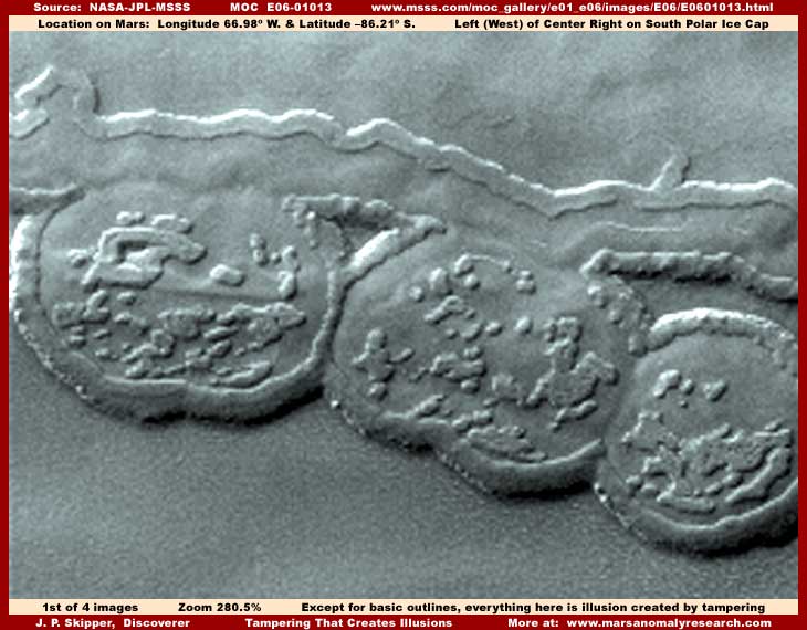
The above first image is a scene from on top of the South Polar Ice Cap and presents broad flat level areas with elevated but low profile rounded and flattened terrain forms as you see here. The scene is all the way from one side of the official strip to the other. This scene and similar ones very much like it are repeated many thousands of times in the South Polar Cap area and are very common. The visuals of the broad flat level areas you see here are, in my opinion, entirely the result of image tampering consisting of a base overlapping pixel distortion combined with a direct overlay coating of semitransparent geometric patterns down at the smallest pixel level and a dithering fog treatment to coat and cover. The flat level looking areas were probably fairly flat and level to start with but the bottom line is that whatever was there is utterly gone underneath this very thorough tampering treatment.
Likewise, the rounded and slightly elevated terrain forms you see here are typical of many thousands of others found in this region. However, most of how they visually appear here is not real or natural terrain at all but a covering coating of tampering treatments similar to but finer and smoother textured than the treatments in the broad flat level areas. Separate tampering treatment jobs often will not overlap each other, so there is a tiny extremely narrow band of real visuals peaking out from under the edge of the overall rounded terrain form tampering coating where it meets the flat terrain. Unfortunately this band is far too tiny in this distant resolution to make anything out within it. The only thing real that has been preserved here is some varying height elevation factors which may be real and the basic elevated forms outlines where the tampering software has been following their basic contours in the much closer resolution available to it but not to us.
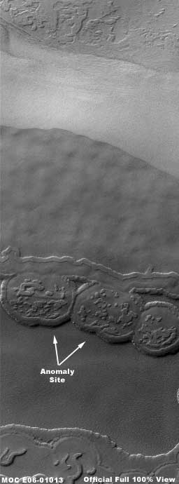
The above wide-area view of this site demonstrates the official science data full size but still quite distant view of this area in the exact same width (still very narrow) as the official strip and without any clarity enhancements by me. But everything from the light color area in the top of the image to the flat level area in the bottom of the image is not real terrain. In the tampering process, the light color tampering area at the top was added to provide change and a reasonable optical transition for the eye or else the upper dark broad flat level tampering area with its undulating pattern blotting everything under it would have looked too strange and too obvious. This illusion principle is used repeatedly in image tampering scenes around the planet but especially prevalent in the South Polar Cap area. Although the total scene may still look a bit strange to Earth viewers new to Mars terrain, most would eventually remind themselves that this is another world and of course things can be expected to look a little different as opposed to here on Earth and think nothing more beyond that.
Further, if some viewers have looked at very many images of the South Polar Cap, they would have seen a great many of these and this scene would be just another one out of a great multitude. So many in fact that the viewer is conditioned to see this as commonplace and therefore all is assumed to be some sort of different but still natural prevalent geology and basically ignored. The very narrow intentionally distant official view also contributes to this perception. So, assumptions are made and all is passed over quickly by scientists moving rapidly through these images. Therefore, because of the distant views and prevalence psychological conditioning, the issue of image tampering is never really suspected, never investigated, and never taken into consideration.
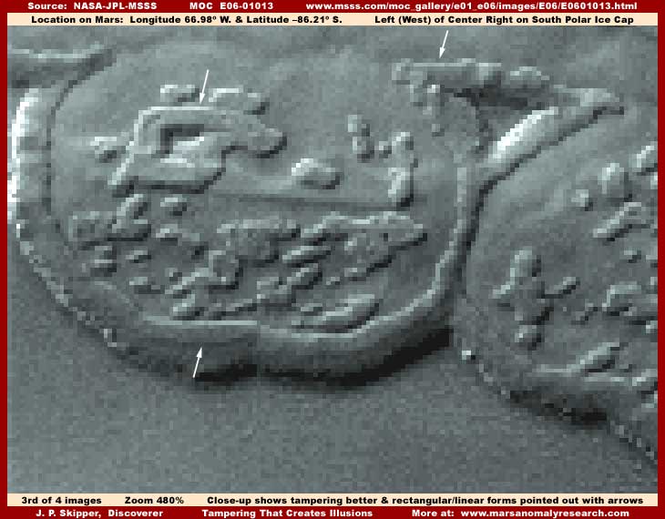
However, in the above third image and much closer 480% zoom view, one can see that there is no natural terrain detail visible here at all, only this fuzzy totally uniform and featureless image tampering "stuff" covering everything and I do mean EVERYTHING. If you can believe that this fuzzy uniform featureless covering coating represents true geological terrain detail, then I've got a bridge to sell you and can make you a sweet deal on it to! As I said above, the only thing that may be real here is just a bit of geometric structures or terrain faintly seen sticking out from under the outer edge of tampering coating that forms the elevated perimeter or collar of the rounded "terrain" forms. Unfortunately, there just isn't enough of this left out of the tampering here to be definite as to what it is.
On the other hand, you can see that some of the smaller elevated features within the terrain form perimeter collar are beginning at this much zoom to resolve into vague linear geometric shapes even through thoroughly covered by the tampering coating. Further, if the presence of the now hopefully better understood image tampering isn't enough clue as to what is being hidden, some larger spots under the tampering coating pointed out with my arrows are showing a definite and suspicious tendency to resolve into rectangular and linear shapes not normal in natural geology making them suggestive of artificiality.
Some of you may remember that I reported on a very similar flat area with elevated but lower profile rounded terrain forms back in February of this year as report #033 titled "Polar Ice Field Civilization Evidence." The difference in that earlier M08-04786 evidence is that the tampering coating was widespread and effective as it is here but a flaw in the tampering coating allowed a small peak at what was underneath and, although tiny in size, it is very clearly rectangular linear geometric multiple forms with multiple rectangular geometric openings within those forms. It spoke loudly of artificiality and therefore highly probable civilization evidence. Unfortunately, the tampering coating in this E06-01013 evidence is more thorough allowing no such peak. Still, I have no doubt as to what this tampering is covering up and I suspect that many of you will draw similar conclusions as well.
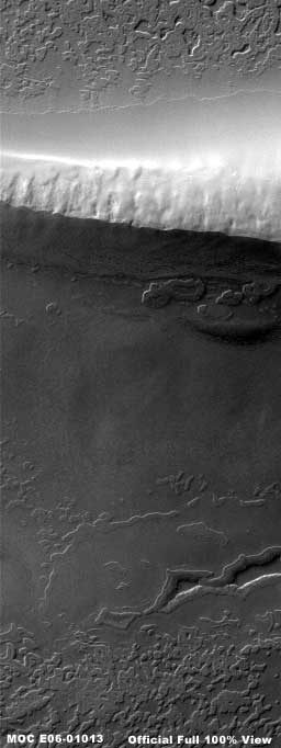
The above fourth image represents another and completely different scene further down in the same strip. The most obvious feature is of course what appears to be a big elevated ridge here with sunlight appearing to shine on and illuminate the upper side while the lower side is of course cast in darker shadow. However, there is no elevated ridge here at all, only smoke and mirror illusion. This impression, in my opinion, while effective, is completely faked. What this really is is a band of thick dithering fog coating tampering treatment spanning horizontally from one side of the strip to the other. A alternating light and dark shading pattern has been put on it to give it a reasonable looking rocky textured appearance at this distant view. Then a light bright reflective looking color tint has been added to the upper half and a dark tint has been added to the lower half starting right down the center of the "ridge," including realistically jogging back and forth creating the rocky texture appearance pattern to mimic the irregularities of a ridge peak line. But, it's still all smoke and mirrors and misdirection and illusion.
It is very well done and the illusion is strong but, if one pauses to consider and think about it (and how many would take time to do that?), take note that the dark tint "shadow" area doesn't limited itself to the lower or near shadow side of the ridge as would a real ridge line shadow, rather it quite impossibly runs in perfectly uniform tint all down the terrain in the bottom part of the strip I've imaged here. Further, in the original strip, it goes down some distance beyond what I have imaged here right to the bottom and off of the official strip length. Obviously, this flaw in the tampering trips this illusion up and reveals the "shadow" as no shadow at all but a artificially applied darker transparent tint that they failed to limit closer to the immediate shadow side of the ridge to properly mimic a true shadow.
I'm not going to waste more image loading space on it here but close examination of this "ridge" at 400%-500% zoom reveals just how fake and artificially applied the ridge peak line is as well as the presence of the basic tampering coating that this is supposed to disguise. This horizontal band of disguised image tampering has thoroughly blotted out something in this area. You can bet it was something very large that had to receive this more severe blot out and subsequent illusion type treatment to disguise the initial blot out tampering because the usual and lighter tampering with resolution treatments would have been insufficient. Frankly, the MOC imaging is, in my opinion, loaded with such smoke and mirror treatments creating illusions but no one seems to want to face this must less deal with it.
Don't misunderstand me here, it is not my purpose here to be super critical of those responsible for this. Actually, they may have started off well intentioned and may have been doing this for so long for our own good as they see it. Maybe or maybe not to. However, the fact remains that we have been kept in the dark about this for so long that we are conditioned by this secrecy into an ignorant, slumbering, and blindly accepting mental state that is not in touch with this reality and there is nothing good about that at all. It's long past time to grow-up, wake-up, and become involved in the reality of our not being alone and the new age that is already upon us whether we want it or not.
Make no mistake about it, this is already a part of and effecting our lives but in ways currently not understood by us. Unless you subscribe to the view that a few secrecy insiders know what is best for all the rest of us and this whole entire world, then we need to be aware of what is really going on and become involved in it for the sake of ourselves and those that come after us. Remember, future generations have to live with the results of what we do or fail to do now. You must decide what kind of legacy do you want to leave for your sons and daughters to have to live with?
SUMMARY POINTS
(1) Image tampering exist in absolute terms in the official visual science data.
(2) Image tampering is frequent and prevalent in that data and not just occasional.
(3) Tampering not only hides real evidence but effectively presents false misdirection evidence.
(4) All viewing this data must take tampering into consideration in their analysis and conclusions.
(5) Image tampering usually covers only civilization evidence.
(6) The high degree of tampering is a direct measure of the degree of civilization evidence on Mars.
(7) This image tampering evidence, if we can face it, tells us we are not alone!
DOCUMENTATION
http://www.msss.com/moc_gallery/e01_e06/images/E06/E0601013.html: This link takes you to the official MGS MOC E06-01013 raw science data image strip that is the source of the evidence presented in this report. If you just want to check the basics and see what the original science data view looks like, then for convenience I suggest using the third listed faster loading medium quality JPEG strip. However, remember that the official strip is narrow offering only a distant view. If you want to examine the evidence closely in higher detail similar to some of what you've seen here, suggest you use the fourth listed better quality but slower loading GIF strip and you will need to use graphics software to zoom in and sharpen up the image.
, Investigator
![]()