
POLAR ICE FIELD
CIVILIZATION EVIDENCE
Report #033
February 25, 2002
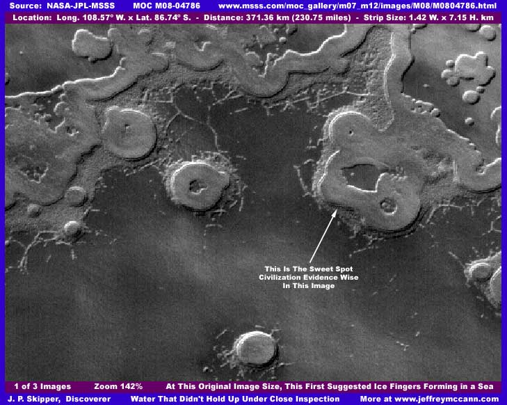
When I first saw this image strip, I thought that I might be looking at ice fingers forming out over a large body of water as a heavy ice slurry. But be aware that science data accepted by the general science community indicates extreme temperature as low as –184º F. in this South Polar Region making standing LIQUID surface water theoretically quite impossible. Yet, I have enough liquid surface water discoveries in this area to convince me that it is cold but that the official science data temperature reading is far from correct.
Another reason for initially mistaking this as water is because the large darker colored mostly featureless level area you see here in the above first image opens out even more (unseen here) into a wider area and extends well below the point ended by the bottom of my above image. From this very distant official view, it has many of the visual characteristics of a liquid such as levelness, a darker coloration, basically featureless without impact craters, and with "island" looking forms in it. However, closer inspection reveals it be more massed civilization evidence at the edge of resolution.
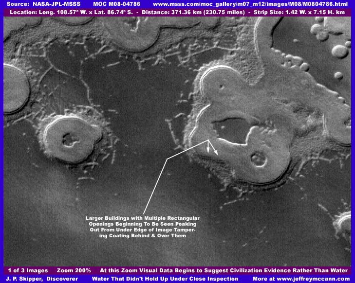
Now look very close at where my arrows are pointing in the above image and you'll see multilevel rectangular structures with multiple perfectly rectangular openings in them. Obviously, a perfect rectangle is not natural and multiples of them uniformly side by side and one over the other equally spaced apart place this hard visual evidence well outside anything that might occur in the natural environment.
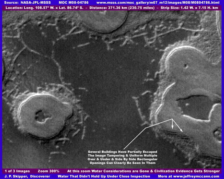
In the above third image, you can see the buildings and their rectangular evenly spaced openings better, even though on a tiny scale here. You may also be able to tell that we are only looking at the partial sides of the buildings because the rest of the structures have been covered by a blurred image tampering coating that extends on behind them in a much wider area. In fact, it is this tampering that creates the "island" form visual illusion. In other words, the appearance of a raised perimeter edge and a raised smooth inland surface is strictly a illusion created by the tampering.
Also note that the straight lines I initially thought might be ice fingers forming turn out to be more suggestive of lines of civilization evidence structures. Finally note the darker level area that I at first blush thought might be water ice slurry turns out to have a very uniform and definite rough porous texture and is not perfectly level but characterized by broad shallow undulations and so is clearly not liquid. On the other hand, it's also clearly not natural terrain either but something dense and thick that is covering the natural terrain.
All this evidence is at the edge of resolution or beyond making it a bit ambiguous. I have no doubt that this is intentional but it's the cards we are dealt . In my experience from looking at thousands of these MOC images, I suspect we are looking at a very distantly seen (by design) big civilization metroplex here. While I expect to take some heat in the short run on sticking my neck out on this and expect some detractors to claim that I often see civilization evidence that isn't there, I believe that in the years to come posterity will confirm this anomaly site to be very close to what I am describing here and that vindication will eventually come.
I suspect that the rounded "island" looking forms are actually densely packed high rise buildings on a low relatively flat water ice plain where shallow melt water can be artificially produced at will. The automated image tampering blurred coating covers the larger and older civilization structures that the distance tampering does not quite get rid of. As I've said before, the automated software works on the principle of recognition of geometric shapes and is very good but sometimes makes small mistakes as it has here in this tiny spot.
In my opinion, civilization evidence like this often starts out on these open empty plains in a ringed configuration with a hollow interior. This forms a basic self contained island configuration. As time goes by, rising population growth stress forces inward growth but that inner space is limited and soon fills up such as represented by the single large round form you see on the left in my third image here. The emphasis is soon on outward growth and older different size rings growing outward merge together forming a larger lumpy looking interconnected more irregular mass such as the much larger form on the right. In order to hide what is really there and yet make the whole appear as natural as possible, these "island" forms have received a light color semi-translucent dithering image tampering treatment to visually merge the individual buildings into a uniform looking mass that makes the whole look like a flattened smooth low natural elevated land or ice form.
You should be aware that most of the science community, because they buy into the extremely cold temperature data, would no doubt counter and say that these odd rounded forms are just the creation of repeated evaporation erosion of carbon dioxide (CO2) ice which they say constitutes most of the composition of the Polar Cap areas North and South. Clearly I do not buy into this. Why? Because I will be releasing soon multiple discoveries of liquid water including in the South Polar Region and this hard visual evidence clearly flies right in the face of the extreme –184º F. temperature data.
Water is the great enabler of life. In this particular anomaly site, although water is not actually visible here, its availability on these plains as a source of shallow water probably artificially melted is nonetheless the key to what is going on here. In my opinion, highly selective "designer"science data passing through National Security filter systems has for many years purposefully created and reinforced the incorrect perception that Mars is a dry, dead world so cold as to be quite hostile to humans in order to buy time for the secrecy types to more thoroughly explore it via much higher visual imaging than is being admitted to or shared with us in order to resolve who and/or what is there.
Now the fact that the water in the MOC imaging has been purposefully left free of tampering where at all possible says that they want to change but the science community having "designer facts" like –184º F. so thoroughly stuck in their heads for so many years can't see it on their own due to their paradigm mindset. In my opinion, the Odyssey probe is the back-up plan to cure this in case no one could find the water in the MOC imaging and it will present water as a mathematical representation conveniently entirely free of civilization evidence that was so inconvenient in the Viking and MOC visual imaging. Mark my words on this! Even now there are references of water ice being on Mars instead of the previously heavily promoted carbon dioxide ice concept as they prepare us for the Odyssey "new" water discoveries that they already know are there. Talk about slight of hand.
As for the light color rounded "island" forms seen here, I have seen many of these forms on the South Polar Cap. In most of those the flat level interspaces between them are usually very light colored and far too distant to see detail and I have also suspected color tampering to create a obscuring glare as compared with the darker color seen here that gives more contrast and detail between light and dark forms. I have often suspected these other forms of not only of being artificial forms but also in some cases taking the form of huge symbols conveying meaning of some kind as they suggest organization and patterns. Remember that civilization evidence that is not familiar to the Earth human eye is the most difficult to identify as to what it really is. Unfortunately, these sites remain in the realm of the ambiguous and that is why I've not reported on them because the resolution is always manipulated so that no real individual detail can be adequately seen. At least here some parts of a few larger rectangular structures with perfectly rectangular openings that have partially escaped the tampering can be seen suggesting a key to interpreting what is really going on here.
In addition to the structures with the multiple perfectly rectangular openings on the edge of the "island" form "shoreline" pointed out by the arrows, the mass of smaller light color structures down immediately in front of them on the lower plain level are, in my opinion, smaller high rise buildings and represent the process of outward expansion. The same with all of the light color areas just out from the "shorelines" all around these "island" forms even though these areas are admittedly far from clear. Also, I suspect these straight running light colored lines or fingers out in the darker plain areas are single lines of high rise buildings as you will note that the closer you get to these lines, the more they begin to break up into lines of regularly spaced individual objects rather than hold up as lines of solid continuous natural geological forms.
Further, I suspect that the large darker colored level interspace areas between and around the "island" forms with the rough porous texture may be well watered plains of vegetation of some kind. Note how some of the light colored lines of structures are often broken up and partially hidden by whatever constitutes this covering of the natural terrain. In other cases, only what may be the roofs of individual structures can be seen as some of the structures seemed to be partially engulfed and/or partially obscured by this darker dense covering mass. However, at this poor resolution rendering everything ambiguous except possibly the larger rectangular structures pointed out by the arrows, I can not rule out that these darker areas are simply image tampering or even smaller and darker buildings merged into a smoother appearance by the distance/resolution tampering.
I've brought this mostly ambiguous civilization evidence to your attention for two reasons: (1) There is actually some very solid hard evidence of artificial structures as represented by the side by side and one on top of the other multiple perfect and uniform rectangular openings which sets this apart from the more ambiguous evidence and deserves to be seen. (2) If these forms represent civilization, then you should be aware of this possibility. (3) I felt that you need to become more familiar with how the distance tampering technique operates in conjunction with object specific direct tampering coating techniques to successfully hide so much and intentionally create illusions and these are good examples of that. (4) The resolution/distancing technique happens at the tiniest levels indicating that much closer resolution imaging exists that is not being made available to us.
One final comment to those out there who are planning or promoting the planning of manned missions to Mars. If you are assuming that Mars is a cold dry dead world, then you need to pay special attention to this growing record of Mars civilization evidence. It would be irresponsible and perilous in the extreme to make such plans without at the very least seriously considering that such a effort may encounter thoroughly entrenched and widespread civilizations that might react poorly to such a landing. Remember, lives are at stake here. Further, getting off on the wrong foot via a combination of arrogant paradigm blindness and ignorance could put us all at risk.
DOCUMENTATION
http://www.msss.com/moc_gallery/m07_m12/images/M08/M0804786.html: This evidence is drawn from NASA/JPL/MSSS's official MOC M08-04786 original strip. My data is extracted from the third listed, slower loading, not map-projected GIF strip because it is easier to take images from due to its straight up and down vertical orientation.
However, the first listed faster loading medium quality JPEG strip and the second listed slower loading best quality GIF strip both work but be aware that these two map-projected strips are heavily angled in their orientation causing the view to be at a different angle than my images here from the third listed strip. Also remember that all these strips in their 100% views only provide a low detail overview and you will definitely need graphics software to zoom in and provide contrast to bring out sharper detail as I have done here in examining the civilization evidence. Good luck!
, Investigator
![]()