
WATER & CIVILIZATION
AT THE SOUTH POLE
Report #038
May 27, 2002
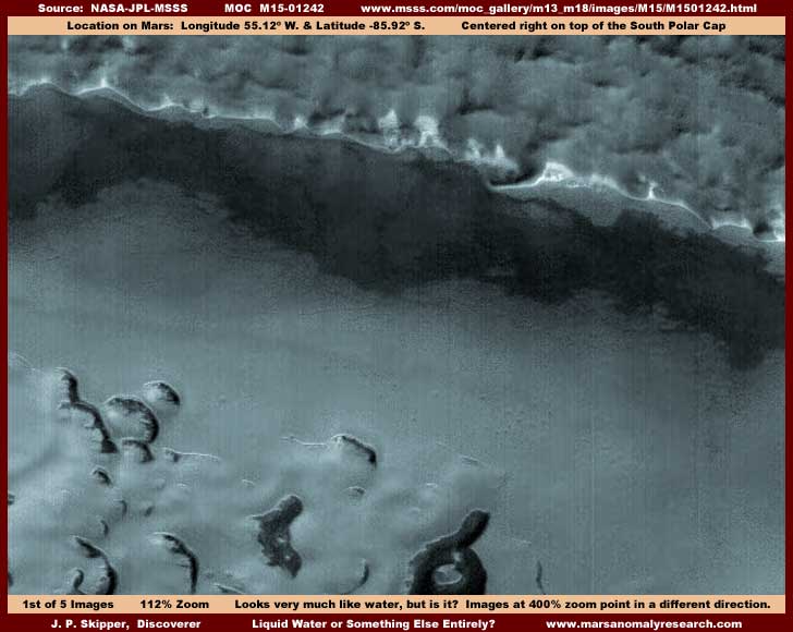
The above first image here is a view from one side of the M15-01242 strip to the other. Looks a lot like water doesn't it. Looks like clear water with subtle reflections and how it borders the foreground terrain certainly indicates that this is water. However, the back shoreline does not look real at all and the background terrain behind that is definitely, in my opinion, heavy covering image tampering and not real. The presence of such obvious image tampering requires a much closer look and, in fact, on closer look there is subtle blur tampering all over this scene including extensively in the water area itself that is almost invisible at the official supplied resolution.
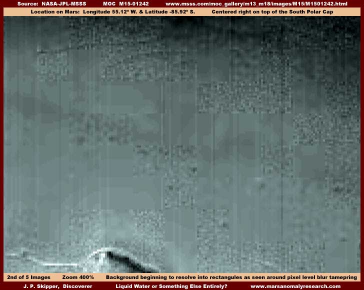
The above second image scene is taken right from the light colored center area in the first image with a zoom factor of 400%. At this much zoom you can see the very obvious blocks of opaque blur tampering aligned along straight pixel rows. In the gaps around the blur tampering you can also see the multitude of tiny rectangles in the background terrain just beginning to resolve. Despite first impressions, this tiny size evidence is a direct indicator of just how truly distant this scene really is. However, despite the tiny rectangular shapes, I cannot extrapolate that these may be true structures or buildings because, except for two possible corridors represented by thin dark lines near the top of the image, which may be a long roadway gap between structures, and the white line and hill at the foreground bottom edge of the image that may be higher reflectivity structures, the blur tampering blocks are too thick and there just isn't quite enough pattern evidence visible here around the tampering to make a reasonably informed judgment call. In fact, I am even suspicious that the tiny rectangles are themselves another form of tampering first applied earlier and below the later blur tampering. I have seen this before and just can't rule it out here.
On the other hand, the image tampering is a fact here as is the fact that it always hides only civilization evidence. Therefore, if the blur tampering's primary purpose is to hide something, then it is logical that civilization evidence is the target. If there is civilization evidence here in this water appearance area, then what does that say for the chance of this really being water as appears in the first image above? Obviously, the civilization evidence would have to be on the bottom underwater. While that is possible given the advanced technology evidenced by Mars civilizations, at least in their dome construction, there is also another possibility to consider.
The fact is that I have never yet caught those doing the tampering in actually completely faking water. That doesn't mean that they haven't, it just means that I haven't caught them at it. What I have seen, and even reported on it a little, is them completely reconstructing the visuals of a water site when tampering messed up the water too much and they thought it was worth preserving and recreating. But, on those occasions, it is my opinion that they recreated water that was really already there and I don't consider that to be totally faking it because there is a underlying truth preservation quality to the tampering. In fact, a very recent example of this is my last #37 two part report titled "More South Polar Cap Civilization Evidence" found HERE where, in my opinion, in part I a large lake was completely covered by tampering no doubt to sanitize it and its surroundings of civilization evidence but the fact remains that they still tried to preserve as much of the "lake" look as possible in the tampering application design. So, while everything seen was tampering and not real, the basic lake site beneath the tampering is probably still legitimate.
What I am also considering here at this site is that that maybe the subtle opaque blur tampering at the official 100% zoom factor is not really designed to cover so much as it is to create the very subtle water surface reflection look at the official resolution factor to accentuate the look of water in the first image above. They may have done this because they realized that the already done very heavy tampering in the background behind the lake and at its shoreline there was detracting from the water look too much. In other words, the blur tampering may have been applied after the initial hiding tampering in relatively fairly good but ultimately inadequate attempt to restore the look of water at the official resolution. The bottom line is that I can't be certain which way this goes here and can only bring this to your attention for you to decide for yourself.
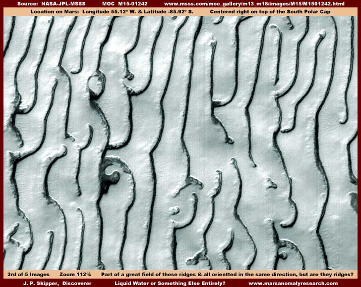
While the potential water site in the first two images here is about two-thirds of the way down the strip from the top, I thought I would give you a look at the above third image. It is a scene of a small representative portion of the upper third of the strip and the features that most characterizes this scene are these many long narrow parallel lines of narrow terrain forms you see. Remember, this strip is of an area centered right on top of the South Polar Cap and the terrain is of ice fields, not true ground. Further, remember also that, despite what the supplied statistics may say, this is a scene seen from a great distance where only the most gigantic of objects can be seen at all and that is by intent. At this great distance, these terrain forms appear by default to be terrain ridges of some kind perhaps caused by some unknown natural processes. At least that would be the natural assumption and that to is by design.
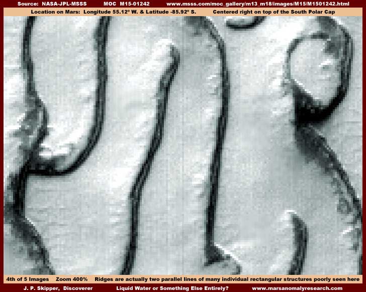
The distance is (again by design) far too great for us to get a decent look at the ridge lines to conclusively tell what they are. However, at 400% zoom in the above fourth and last image, you will note that the dark ridge lines now appear to possibly be resolving into two parallel perfectly in sync lines or rows of tall vertically oriented upright rectangular structures. Most of the lines seen here are seen on end and this view orientation causes them to merge together. Even so, if you look very close, you can still tell that they consist of twin parallel dark row lines. However, note in this scene that where the lines are seen at a very slight side angle, such in the slight curve in the line on the lower right edge and to some extent on the mid and lower left edge, the continuous lines are seen to start breaking up visually into individual upright structures. The quality of this visual evidence resolution is quite poor but is nonetheless still telling. Look very closely and you should be able to see that the block blur tampering already seen in the possible water area is also a part of the light color areas between these "ridges"and that tends to support that this type of tampering is designed to hide, at least in this location.
Let's put it this way, at minimum, even with the intentionally poor resolution and tampering there is still plenty enough evidence here to point away from the initial natural geology assumption and toward the possibility of artificiality and civilization evidence. This type of evidence is very similar to the evidence presented in Part II of my recent previous report #37 as linked to above and most of the assessment as to the terrain forms in that previous report also applies to this particular evidence as well. I have seen great expansive fields of this type of terrain form evidence presented here and in report #37 and seen by me in other strips covering many hundreds of square miles. The point being that the closer and more one looks at this type of very distantly seen poor quality evidence, the trend in the visual evidence does not adequately support natural geological explanations and, if this evidence trend continues, we are talking about the possibility that the bulk of the civilization populations on Mars numbering in the many millions are significantly concentrated at the South Polar Region and I suspect that concentration is almost certainly based on the consistent supply of water there in the form of water ice that can be converted to liquid. On Mars water is everything.
Now be reminded that at this point this being civilization evidence is strictly speculation with all the pitfalls that speculation carries with it. But be also reminded that my conjecture is based on analysis of hard evidence, not fanciful imagination or some personal belief system of mine as some will no doubt wish you to believe. Additionally, regardless of my conjecture, remember that the sheer magnitude of the image tampering in the MOC data and Viking data before it is so extensive that this alone speaks volumes about the high probability of the civilization evidence that I am interpreting and reporting. If, upon getting more exposure to this evidence, it starts pointing in a different direction, rest assured that I will be back peddling and reporting in that direction as well and without qualm. What you have to understand about me is that there is nothing personal in this conjecture, I merely follow the evidence in the direction that it points. As with any person, including any and all at NASA or JPL or MSSS, the interpretive aspect of viewing any evidence is subject to human error. Still, I am satisfied that I am on the right path and time and posterity will tell us all where the truth lies.
Frankly, if the evidence would point in a different milder direction, even the direction of ancient long dead civilization evidence on Mars, my reporting would be less controversial and more palatable to others and life would be easier for me in pursuing this task as well. However, I'm compelled to report the evidence as it appears in front of me and this road will no doubt be a bumpy one. With that bit of aside stated, there is more to report arising from this strip as appears in the final image below.
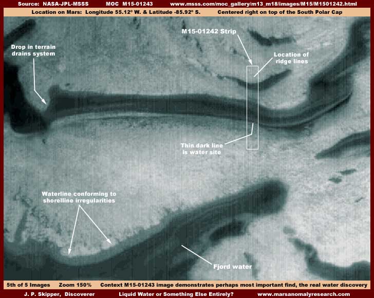
The above fifth image is drawn from the companion M15-01243 wide-angle context image found at the same URL. Here you can see the M15-01242 narrow-angle strip outline with the water site and the civilization evidence areas pointed out within it. The image is a bit fuzzy at 150% zoom because this is a lower resolution wide-angle context image. Take note in the upper left where this long melt water catch system on the ice cap field has apparently overflowed into a lower level catch system. This flow over time has cut down the terrain at its left end forming a drop down that has at some point mostly drained the system of its water leaving only a little residual water behind and a lot of terrain dark staining defining the original water level.
Based on a lot of other evidence of this type that I have seen on the South Polar Ice cap mass and as will also be presented in my upcoming book, I suspect that the residual dark staining is a result of dark color organism living in the water that absorbs solar radiation and is able to a limited extent to transfer that retained heat to its immediate environment and help create liquid water conditions for itself from the ice mass. I suspect that this is a variation and adaptation of the same aquatic organism I've previously reported on that is prevalent in the water supply all over the planet. Over time, the living and dying process of this particular form of the organism coats the bottom and sides with dark tinted debris staining it a darker color with the bottom naturally receiving more debris and therefore a darker color than the sloped sides of the trough depression. When the water is mostly gone, as is essentially the case in this particular M15-01242 trough system, this staining remains marking the trough depression in the terrain.
However, at the bottom of this wide-view companion context image, you can see a dark color fjord finger sticking into the ice mass that appears to still retain its water. Now remember that this is a very distant view and that kind of view can sometimes be a bit misleading. Even so, you can see how the waterline conforms to all of the irregularities of the terrain shoreline sloping down into this fjord finger system. That tends to indicate that water is still in this system and it does overall look very much like liquid water is present. Many scientists accepting insufficiently cautiously the National Security filtered extremely cold temperature data fed to them in years past and following their training and their own paradigm mindset will no doubt find this observation of liquid water as presented here unacceptable but the hard visual evidence still speaks for itself and must be considered.
As you will find when some of the discoveries of this region presented in my book comes out, this big deep fjord water on the Ice Cap mass is nothing unusual at all but quite typical of the region. The cause is partially tied in with this aquatic organism temperature manipulations as well as general temperature extremes obviously not being as severe as the science data readings have reported. Even without the organism as a factor, these ice vs. water conditions are typical of the Polar regions here on Earth. When the scientist gradually wake up to this inevitable reality, the next obvious step will be to consider that conditions for the existence of life in general are a lot more favorable than previously thought. When that concept settles in a bit, maybe some will eventually be able to break through their self imposed paradigm mindset barriers and get down to the serious business of considering that there may actually be the possibility of civilized life on Mars. Before that though, I suspect there will be much gnashing of teeth and resistance.
As for you secrecy types, the choice is yours! You know what your A.I. super computers project as well as your own assessment teams and the inevitability of this! The question is, are you about procrastination and the continued fostering of ignorance and pretense with all the terrible risk to us all that comes with it or are you ready to now get behind change and bring the people into some degree of informed awareness? In other words, are you about positive leadership or about being rigid and enslaved by your own special paradigm and decades old planning mindset? Remember that ignorance does not foster rational behavior and the tree that bends is less likely to break. The choice is yours.
DOCUMENTATION
http://www.msss.com/moc_gallery/m13_m18/images/M15/M1501242.html: The easiest way to check behind me on this discovery evidence is to access the official science data strips shown above. For M15-01242 there are four strips to choose from, all four work, and all four have the same orientation matching the context image but be aware that the the third JPEG and fourth GIF strips offer a closer and larger view. Use the third listed medium quality JPEG strip for convenience if all you wish to do is check behind me on the basics but choose the fourth listed better quality GIF strip for its higher detail potential if you wish to download, develop, and zoom in on your own images for closer inspection. The same advise for the M15-01243 context image strip available at the same URL except note that the closer and larger third and fourth strips have been flipped vertically and horizontally from the view orientation of the context image and the first and second strips which also match the view orientation of the context image. Good Luck!
, Investigator