
MORE SOUTH POLAR CAP
CIVILIZATION EVIDENCE
Part I of II
Report #037
May 16, 2002
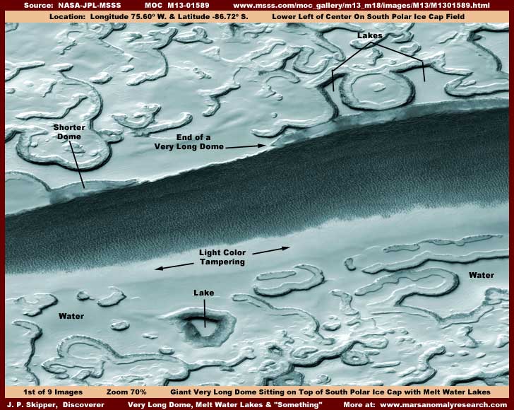
The above first image here points out a anomaly site scene in the M13-01589 strip with the primary feature here being a very long dome, the left end of which is pointed out with an arrow. Before we go any further here, you should be aware that the above scene is from one side of the original strip to the other and that this site is located right on top of the South Polar Cap ice field and that means that the terrain you see here is ice field not to be confused with true ground. You should also be aware that this scene view is from a great distance and the only things that can be adequately seen here are giant objects, so try to resist the natural tendency of the mind to reduce this scene to a more familiar but incorrect scale. For example, a large 5-10 story building would be too small to be seen down there even as a tiny spec.
This general terrain is characterized by melt water conditions. The extensive flat areas you see are I suspect areas of the ice fields that have gone through melt conditions where shallow liquid water sits at times on top of the ice. The flat areas demonstrate that this liquid leveling process is occurring either continually or periodically. It may be hard for you to believe but the rounded terrain forms you see are mostly artificial building base constructs in this terrain and the darkened rims are civilization evidence that has partially and intentionally been left out of a light color coordinated ground hugging fog image tampering that is so pervasive in this scene and to a very large extent shapes the illusion visuals of it and our perception. The huge dark area extending from one side of the strip to the other looks at first glance as though it may be water in a large shallow depression area but the dark coloration is actually a great multitude of rectangular structures that, incredible as it may seem to us here on Earth, is almost certainly densely packed buildings. There will be more evidence for this later and especially in Part II of this report.
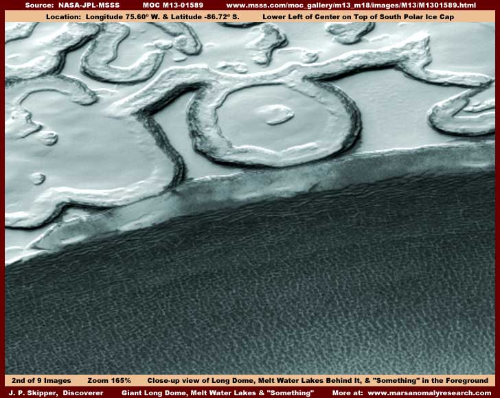
The above second image offers a closer 165% zoom view of a portion the large dark mass, the very long dome, and the terrain immediately behind the dome. At this distance the large dark mass and what makes it up is too ambiguous, so we'll skip that for the moment. This image does offer a decent look at the very long dome though. You can clearly see its semitransparent qualities, its uniform shape, and the light reflections off of its smooth hard translucent surface and the consistent location of those reflections along a single narrow axis down its length indicate that this is very definitely a rounded object across its girth consistent with the dome concept. Please also note that fact that the dome blocks the view of the edges of the rounded terrain forms immediately behind it demonstrating that this is a 3-dimensional object high enough in the air to block our sight of parts of the terrain form edges behind it. Also, don't forget the true very distant scale involved here, which makes this dome a gigantic thing.
A close look at the dome at 200%-500% reveals a multitude of very tiny but organized uniform detail, just too small to be able to conclusively tell what it is because of the extreme distance involved here and the fact that fine detail tampering has been applied, in my opinion, within its overall dimensions at much closer secret resolution imaging not released to the public. All that can be seen are patterns and not individual structures. Therefore, I cannot claim conclusively that there are buildings inside the dome as is, in my experience, usually the case with these structures. On the other hand, the organized patterns definitely imply that artificial structures are what is inside.
This brings up another point, why did the tampering not cover this huge object up? The reason, as I've stated in other reports, is probably that the automated tampering software is based on recognition of geometric shapes (straight lines, right angles, squares & rectangles) and does not necessarily recognize transparency alone as a artificial construct. On the other hand, if it sees well defined geometric shapes inside a transparent object, it will cover those geometric shapes and naturally the transparent object is often inadvertently covered as well. However, in this particular case, when examined very close, it appears that a very fine dither pattern fog/blur treatment has all been applied to the contents of the dome in a very close view not available to the public. Since this was applied within the confines of the dome's outer dimensions, the outer perimeter shape was not too badly effected leaving the overall view of the dome intact for us to see in this quite distant view.
In the background behind the dome are two large flat areas confined within the boundaries of terrain forms with dark edge fronting the flat areas and both are separated by a big round terrain form. When you see a closer view of this area in one of the images in Part II, you will see that the flat surface is very smooth in the "lake" on the left. On the other hand, the lake on the right is characterized by a very flat smooth surface up closer to the dark "shoreline" edge in the flat area but with low ridge and lump patterns further out in the center of this same flat area. Also, note that the dark narrow strip "shoreline" on the terrain forms at the edge of the flat areas is actually two lines of parallel "ridges" that follow in perfect sync with every wiggle of the "shoreline." Finally, note the soft feathery foggy terrain hugging light color featureless "stuff" within the ringed interior areas of the terrain terrain forms. Remember these factors as they will become more important deeper into this report.
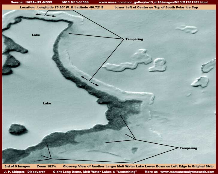
Now here in the above third image you see a large lake found further down in the strip on the left edge. Now what I'm going to tell you about this lake is going to be typical of all the other "lakes," "shorelines," and terrain forms in this entire strip. This flat level area has all of the characteristics of a lake just like the two "lakes" immediately behind the dome. Note that the flat surface of the lake may be just slightly lumpy but every bit of it is still the same level very characteristic of liquid because liquid of course always seeks its own level. That perfect overall levelness tells us that, if this is iced over, then the ice goes through at least periodic melt conditions, which results in and maintains this clearly evident level appearance. Further, this level flat area is confined in a irregular depression area with clearly defined higher elevation terrain edges surrounding it, which is another characteristic telling us that this flat area represents a liquid and just where you might expect to find water. Once you see all of the standing liquid water hard evidence I have been holding back and will be presenting in the book coming soon, you will come to understand that standing LIQUID water exists on Mars including at the South Polar region and even on the Cap itself despite what the temperature is supposed to be there. So, while this may be a bit incredulous to some, it is old news for me. Don't worry, this issue of liquid surface water on Mars will start unraveling and resolving itself soon.
Meanwhile, while I acknowledge that water is present here in this flat level area, I'm also going to state that none of it is actually visible, including even in the form of ice. In fact, there is very little in this third image scene that is real. The apparent icy conditions of the lake surface is, in my opinion, actually a close hugging light color fog covering tampering treatment applied on a very fine scale in a secret original strip with a much closer view than released in the public domain. The lumpy lake surface is actually the tampering application following the vague contours and shapes of something else that exists on this lake bed but which has been completely covered up. Now understand that this tampering does not impact the basic levelness of the lake surface or alter the fact that this is in a irregular depression just as it appears and just where you might expect water to be. It's just that we can actually see it because of the tampering coating.
Likewise, the dark narrow band around the shoreline of the lake is a dark dithering tampering treatment that covers something there. In the foreground just in front of the lake and dark shoreline are large broad areas of a obvious foggy tampering treatment that covers something else there. On the right and top edges of the lake just outside the dark band of tampering and inside a line of natural terrain ridge line is a very subtle form of light color coordinated tampering. This same finer more subtle tampering carries out into the broad terrain covering and smoothing out everything there including the tops and centers of the few terrain forms. In other words, just about everything in this scene is tampering coating not only designed to cover up something but also designed to create illusions about what we are seeing.
This illusion is at its greatest effectiveness at the normal 100% resolution image sizes supplied for the scientist and the public to view. To what purpose? Someone knew that most researchers would be viewing these strips very quickly simply because there are so many of them to cover. That one factor means that, unless something very obvious and unusual really strikes the eye quickly, everything else is going to get passed over in a hurry and no researcher is going to admit that he breezed through these strips too fast. Combine this with a blind paradigm mindset and that means that the great bulk, if not almost all, researchers are going to see only what the secrecy types want them to see, which is essentially a sanitized image of any real evidence. Few and far in between will be any researchers that will actually zoom in on a strip that looks innocent on the surface and look it over close and critically. That would severely cut into the total number of image strips that can be practically viewed.
Likewise, I suspect this is why the third listed straight vertical GIF strip, in the earlier imaging that had only three sets to choose from, was so often flipped. They knew that most researchers would be connected with academic institutions that would have university supplied broadband fast connections and they would quickly learn to choose the third listed strip with a fast connection simply because the strip is the easiest to scroll through much faster than can the sinusoidal map-projected (angled) strips where one must stop and start and reposition the image for further scrolling. This doesn't apply to everyone but I suspect it does apply to most.
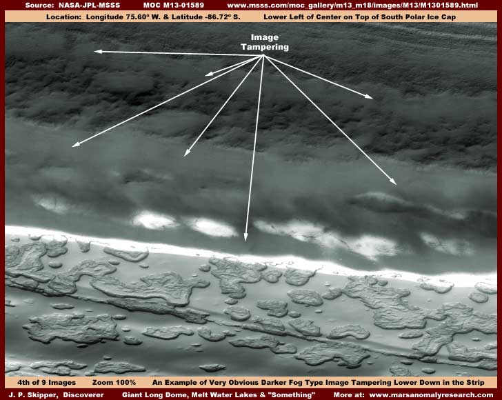
The above fourth image here is included just to give you a look at the most obvious example of tampering in this strip and just to demonstrate that tampering even the rankest amateur should be able to see is in fact going on in this strip. This is a broad type of dark fog/smoke/cloud type tampering application that stands out sharply from its surroundings even at this normal size view. In fact, it was probably applied in this same view. I trust that no one believes that these South Polar Cap ice fields are on fire and the burning ice smoke is confined to this nice narrow band of soft, fluffy, porous, featureless "stuff?" Less obvious is the darker lumpy terrain back of it and under it in the background, which is also false. Even less obvious is the slightly dark tint but clear treatment over the normally bright high albedo terrain in the foreground that is designed to convince us that there is a slope in shadow at this point leading down into the darker stained depression bottom and back up a slope in the foreground not seen in my image here. The problem is that the clear tint is too uniform and the dividing line at the top of the slope is too perfect and passing over terrain forms without effect demonstrating that it is an application rather than true shadow.
The truth is that this terrain is actually quite flat. Further, what you can't really see here unless you look at the whole strip closely is that the resolution in the lower half of this strip below this large scale obvious tampering has been reduced so that objects are seen at further distance and smaller than in the upper half. The dividing/transition line between these two halves is no doubt hidden under this band of obvious tampering. The down slope, depression floor, and up slope near side is a illusion designed to break up the ability to clue into and compare the sizing in the upper and lower areas. So, you see, the tampering is not just about covering things up, it is also about creating illusions and altering perceptions. When you are a scientist with many years of accepting the paradigm mindset, this is very effective manipulation but when you are a nobody like me coming out of the woodwork with little exposure to the previous decades of manipulation, its just more horse crap. This demonstrates that one strategy just doesn't fit everyone.
Okay, I can't put any more here in Part I without making it far too cumbersome and slow to load, so click here on PART II for more.
DOCUMENTATION
The easiest way to check behind me on verifying this discovery evidence is to access the official science data strip at the MSSS link below.
http://www.msss.com/moc_gallery/m13_m18/images/M13/M1301589.html
There are four strips there to choose from, all work, and all have the same orientation. However, note that the first listed JPEG and second listed GIF strips are map-projected (angled) and they are also smaller. I would suggest using the much larger third listed JPEG or fourth listed GIF strips for their closer view. Use the third listed not map-projected medium quality but faster loading JPEG strip if your purpose is just to check behind me and verify the larger more obvious discovery evidence identified here. But, if your purpose is also to download and do your own imaging work to look closer at the fine detail discoveries, then I suggest using the fourth listed not map-projected better quality but of course slower loading GIF strip for its higher detail potential to work from.
In fact, because there is always some loss of very fine detail in images developed for presenting economically (space wise) on the Web due to image compression, if you do have good graphics software and download the fourth listed GIF strip, I urge you to look around for yourself at the terrain forms at 300% to 500% zoom factor. You will see the tiny terrain form civilization evidence a little better than can be presented here on the Web. Note that the dome is located near the top of the strip, the large lake about 70% of the way down the strip on the left, and the terrain form tiny detail scattered around the upper half of the strip below the dome.
, Investigator
![]()