
MORE SOUTH POLAR CAP
CIVILIZATION EVIDENCE
PART II of II
Report #037
May 16, 2002
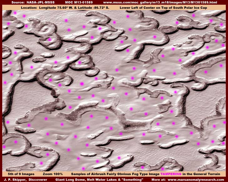
The above fifth image is included here to give you a wide representative view of the South Polar Region ice fields and the way they generally look in the many strips of this area of Mars. It is also included to familiarize you with at least one of the most obvious types of tampering, the fog airbrush treatment areas as represented by the many violet dots. While the dots are irritating and interfere with looking at this scene, they also demonstrate in a inescapable way just how pervasive this one type of tampering is and, unfortunately, it is only one of many forms used in this scene.
Further, this broad airbrush tampering treatment is all about creating an illusion of these terrain forms looking as they do here when the reality is somewhat different. The fact is that almost all of this scene is tampering, the shapes you are looking at here are misleading, and the real terrain would look a bit different than you see here. The slightly higher elevation terrain forms are actually bigger and wider than they appear here with these dark relatively narrow bands and filled with civilization evidence. The low level flat depression areas exist and probably do represent controlled ice melt water but we can't see it because the flattened level patterned surface you see in the above image is also a covering tampering done at a very close view not available to the public. It is done in a fine dithering pattern on a tiny scale and this winds up covering everything in sight but also following to some extent the vague contours of structures that exist in the depressions creating the line patterns you see. I suspect that the broad airbrush treatment on top of that done at a lesser resolution, hides the outlines of larger structures that print through the fine dithering treatment a little too much. When the distancing technique factor is added, this is very effective tampering and hard to spot because increasing the distance makes this type of already small scale tampering appear to hug the terrain and merge with it as opposed to the broad airbrush application applied at a lesser resolution. The dark narrow bands are a semi-opaque dark tint that is sometimes a thick dithering application designed to outright cover and hide and at other times a semi-opaque tint designed to blur and at the same time accentuate.
The goal of the illusion aspect of this tampering as opposed to the hiding aspect is, in my opinion, to create the look of possible ice bound lakes while at the same time sanitizing the scene of any suggestion of civilization evidence. As I have repeatedly reported, it was apparently their original intent to "discover" via the MGS MOC mission the water they already knew was on Mars as per at least the old Viking data, which is itself heavily tampered with. Remember, this kind of decision making must span many years and would have been made long before the MGS mission actually got underway. However, after the release of the MOC data and it was discovered that scientist apparently can not find liquid surface water on Mars unassisted, they have apparently just went with the flow of that as it buys them more time.
I suspect they are adopting a wait and see attitude with respect to the revelations you see here at this website. If the public ever picks up on this material and wakes up in mass to the truth about Mars, then I'm sure they will go with the original contingency planning. But, if the public just passes this material off as the wild dreams of some poor lone and deluded "crank" at some obscure website, then they go with that flow to buy more time. They know that ultimately this secret will eventually get out, the only variable is the matter of timing as to when. More delay just works in their favor even though the public slumbering along in ignorance is not a good thing at all. I suspect they know the public well (decades of successful manipulation speaks for itself) and believe that the public doesn't really want to know about this (subject to many but minority exceptions) and prefer the contentment of pretense. It's all a matter of perception and timing.
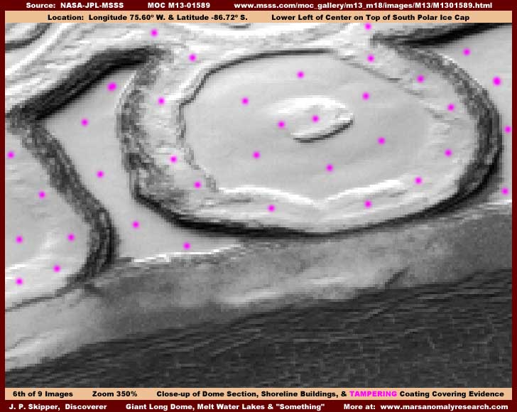
The above sixth image a 350% zoom view of a section of the dome and the lake areas immediately behind it. At this level of zoom and above, it appears that there is a very fine dithering tampering application applied to the dome interior obscuring the contents. This has been done at a very close resolution view not available to us. When drawn back and seen from the extreme distance supplied as the normal official view, the fine tampering basically disappears within the confines of the dome but leaving the basic huge dome outline intact. Since the direct fine application and the distancing technique together has successfully obscured the contents of the dome (no doubt geometric patterns), the automated software saw its job as complete and did not attempt to obscure the outer dimensions of the long dome by the usual broad airbrushing technique applied at lesser resolutions as it has otherwise done in the surrounding terrain.
However, as dramatic as the long dome is, the real key to understanding what is really going on in this scene does not have to do so much with the dome as it does with the terrain immediately behind it. At this zoom you can just begin to see pixel overlap tampering that essentially cuts resolution and creates blur all along the dark shoreline "ridges" that is giving their edges the jaggies. The natural first reaction is to assume and attribute these "jaggies" to the pixelization as a result of the 350% zoom but this is not what is happening here. The fact is that this whole strip has been subjected to this particular pixel treatment as a foundation tampering at a much closer and higher resolution view not available to us. This and the dark tint applied to the shoreline ridges is very effective in its blur effect but, if you will look very close, you can still see that these dark narrow bands in the above image scene are not natural ridges after all but long parallel lines of many individual tall vertical structures. In fact, despite the heavy blur, the tops of these structures can even be seen immediately behind and up against the back of the dome as seen just over the top of it. Even had this not been so, remember that this is ice field, not ground, and long lines of high ridges forming at the perimeter in perfect sync with the shorelines of all of these lake depression areas would be very hard to explain via any natural geological process. All one has to do is stop and think about it a little rather than just quickly making assumptions.
Now look at the fairly obvious airbrush technique applied to the areas represented by the violet dots. Note that most of the center area within the round terrain form, except for a small part of the center "island," has been obliterated completely by the airbrush tampering. Note especially how this has been applied to the left and right side darker areas of this form to only partially cover and intentionally leave a darker narrow band visible, even though heavily blurred. Further, if you will get your eyes close to the screen and look very closely, you can see that the "jaggies" at the dark shoreline edge do not extend out into the middle of the lake depression area to the immediate left of the round terrain form. That is because the covering airbrush technique was applied later at a different lesser resolution view after the foundation pixel overlap tampering was applied at the true but secret maximum resolution view. This demonstrates that the view being supplied to us in the public domain is not only doctored to distort, hide, and manipulate our perceptions but is definitely not the highest resolution view available of these features on Mars and that pixelization tampering has been used to limit resolution to that released into the public domain. This is obviously their answer to having to agree to release the Pathfinder and MGS MOC data into the public domain before ever being able to get the funding for those missions demonstrating that there is always more than one way to deal with such "problems."
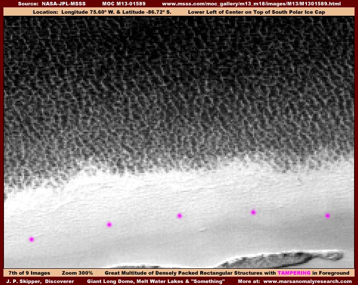
The above seventh image offers a 300% zoom view of a representative section of the dark mass immediately below the long dome. If you sit back and view this from a normal distance from your computer screen, you will not see much of anything but a jumble. However, if you get your eyes down close to the screen and study this dark area carefully, you should be able to see that the dark jumble is actually densely packed upright vertically oriented rectangular structures. Further, a great many of the individual vertical structures are in lines extending from the dark upper portions of the image to the dark lower portions in vertical lines that have a very slight upper left to lower right angle. This line concept is one that I have learned to recognize as at least one prevalent pattern of civilization building evidence on Mars. Generally the building patterns elsewhere seem to include light color buildings in long lines that seem to flow from the upper to the lower slope of a terrain but close inspection also reveals dark buildings in the inner spaces between these lines, all evenly spaced. Rather strange but I suspect this has to do with the lines of the buildings parallel to and facilitating water flow down a slope but cannot be conclusive about this yet. One thing is for sure, for a arid world without great oceans such as we have here on Earth, the psychology of Mars' residents is heavily oriented on WATER and never underestimate the influence of this concept.
The light color area with the violet dots is a covering fog tampering application that has been applied at a fine very close view. The tip off to this is that this is a fine tiny scale application made to appear as a ground hugging coating by withdrawing the resolution to considerable distance after the application. The tiny scale application following structure contours causes vague patterns of the structures under the coating to imprint through the application giving the surface a pattern look that mimics the look of an ice field. While it is not very self evident here in this scene, the vertical oriented tall rectangular structures are heavily blurred due to the foundation pixel overlap tampering technique creating the edge jaggies that can be just barely seen at the terrain form edges at the very bottom right of the image. Note that the light color area exhibits no such jaggies again demonstrating that this fine detail fog tampering was applied later at a more distant view because it is covering the jaggies. Since the dark mass is dense rectangular forms and the pixel overlap tampering is also a rectangular pattern, the visuals of this type of tampering with its jaggies evidence disappears into the thousands of rectangles in the dark mass and can't be seen there even though their effect in obscuring the dark mass individual details is pronounced. Once again, note that the jaggies do not extend out into the light color area and are covered up by that tampering coating.
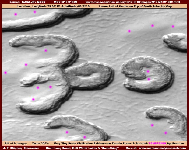
Okay, I couldn't resist including it, the above eighth image at 300% zoom is dramatic isn't it. There is that prominent gigantic number "309" looking back at us. I can't say whether this number is there by artificial intent or just there as a chance configuration of the terrain forms and their development. What I can say is that these terrain forms you see are loaded with civilization evidence just as are almost all the many terrain forms in this strip. It isn't very apparent here in the above image but you will be able to see it better in the next image below providing a 500% zoom factor. Even so, if you get your eyes close to the screen and carefully, you will still be able to tell that there are massed vertical rectangular forms occupying all of the dark areas of these terrain forms. The violet dot areas once again demonstrates the final covering airbrush tampering treatment, which is thick in some places and thin in others but in all cases quite effective in hiding what is really there.
However, one of the main reasons I'm showing you this image is for you to check out the innocent looking line patterns in the flattened level depression possible water areas. Note that the airbrush treatment has been applied over the top of some areas of these patterns. I have no conclusive proof of this but I suspect that these line patterns are not rough areas of ice as it may first appear but a fine very close view applied tampering and these patterns are actually lines of structures very similar to the lines of structures but without the covering tampering coating as seen in my previous report #33 "Polar Ice Field Civilization Evidence" found HERE where you can get a better even though distant look at these line patterns. What I am getting at here is that just about everything you see has been subjected to several forms of tampering. You must learn to recognize this tampering for what it is if you are ever to understand what is really going on on Mars with respect to the civilizations that occupy that planet.
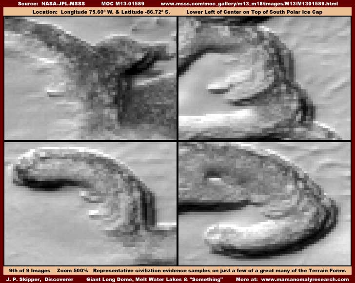
The above last ninth image offers a 500% zoom view of a representative sample of just four different terrain forms out of the multitude of terrain forms in this strip. At 500%, the blur is bad but made much worse by the pixel overlap tampering that is creating the jaggies you can now clearly see especially well in the dark black areas. However, even so, you can still see that the elevated objects on these terrain forms can no longer be confused with natural geology but are resolving out of the tampering blur into many densely packed vertically tall rectangular structures that I suspect are high rise buildings. Now I don't claim to see the individual buildings, rather what I see is a collection of densely packed vertical oriented rectangular structure outlines very strongly suggestive of civilization evidence buildings.
This is the same type of thing seen in the "309" terrain forms in the #8 image, just seen closer here. It is also the same thing seen in the dark bands in the #6 image of the area immediately behind the dome, just again seen closer here. Now I suggest you get your eyes down close to the computer screen and look closely in the upper left, upper right, and lower left images and note that each has a single large light color rectangular low profile flat top horizontally oriented structure protruding out to the left from the mass of high rise vertically oriented rectangular structures to its right. Do you think this is coincidental in three different images of three different areas of terrain? Looks mighty artificial to me. Also notice the abrupt height change of very tall structures from the lower level structures in the upper right and lower left images. One thing is for sure, despite the very heavy blur caused by the tampering and distance involved, you can still tell that these terrain forms at the very least no longer appear to be natural geology but something else entirely beginning to resolve out of the blur and that "something" is strongly suggestive of artificiality and civilization.
Here again you can also better see how the jaggies at the terrain form edges does not extend out into the smooth airbrush tampering, once again demonstrating that this is pixel overlap tampering applied first at a very close resolution as a foundation treatment to cut resolution and promote blur and then later the fine fog dithering pattern and then later still after that the broader airbrush tamper was applied covering up much of the first and second tampering and also sculpting terrain illusions. So don't confuse this with normal pixelization as too much zoom is experienced. Note also, as seen in the upper right and lower right images, the few lines of rectangular structures out in the depression flat areas to the right of the terrain forms that are partially showing through the airbrush tampering are still showing some signs of the jaggies. In other words, where the final smooth covering airbrush tampering is thin and the true terrain detail shows through, so does the foundation pixel overlap blur application.
So you see, everything is not what it first seems in the MOC imaging. Where things initially look innocent enough, close careful inspection reveals much tampering as well as civilization evidence where it did not at first appear to be in the supplied public domain image strip resolutions. I am satisfied that, even though we can't really see it because of the tampering, this Cap ice terrain is still a story about shallow melt water in the many depression areas. But I've learned one thing about Mars, where there is the potential for liquid water on the planet, there is going to be civilization evidence. Further, an elite secret few have decided that you can't handle this concept, believe that you truly don't want to know about it, and have decided for you that you should not be and do not need to be seeing this.
The question is, are they right? If they are not right, then you need to step up to the plate and become involved by sending as many people, discussion groups, media types, and congressional leaders to this information as possible, thus raising exposure and awareness across the board. Demand a official investigation into this material to prove or disprove its authenticity. Whether this information languishes here on this lone website or spreads to a wider audience is really up to you. If you in the public abdicate responsibility for yourself and your future and do not become involved, then you must be resigned to the consequences of leaving all input and decision making entirely up to a secretive few who will of course pursue their own agendas with your money and without your input and you and your children and your children's children will have to live with the results.
DOCUMENTATION
http://www.msss.com/moc_gallery/m13_m18/imagesM13/M1301589.html: The easiest way to check behind me on this discovery evidence is to access the official science data strip shown above. There are four strips there to choose from, all work, and all have the same orientation. However, the first JPEG and second GIF strips are map-projected (angled) and they are also smaller. I would suggest using the much larger third JPEG or fourth GIF strips for their closer view. Use the third listed not map-projected medium quality but faster loading JPEG strip if your purpose is just to check behind me and confirm the larger more obvious discoveries mentioned here. If your purpose is also to download and do your own imaging to look closer at the fine detail discoveries, I suggest using the fourth listed not map-projected better quality but slower loading GIF strip for its higher detail potential. In fact, because there is always some loss of very fine detail in images developed for presenting economically (space wise) on the Web, if you do have good graphics software, I strongly urge you to download the fourth listed GIF strip and look around for yourself at the terrain forms at 300%-500% zoom. You will see the tiny terrain form civilization evidence a little better than can be presented here. Note that the dome is located near the top of the strip, the large lake about 70% of the way down the strip on the left, and the terrain form tiny detail scattered around in the upper half of the strip below the dome. Good luck!
, Investigator
![]()