
FIRST DISCOVERY OF STANDING
LIQUID WATER ON MARS
Report #002
7/27/00 (orig post) - 12/28/00 (1st rev) - 06/19/03 (2nd rev)
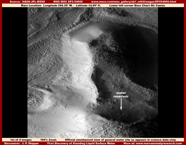
This water site evidence as drawn from the MGS MOC official SP2-54006 strip was and continues to be, to the best of my knowledge, the first true legitimate standing liquid surface water discovery on Mars formally reported on. I found this big pie shaped surface water reservoir prior to 7/20/2000, first posted it on 7/27/2000, and some media outlets picked it up creating a fair amount of attention and of course controversy.
Now please understand that the discovery I'm referring to here is very important standing liquid surface water comparable to lakes and streams, etc. as bodies of water. But, don't confuse this with the very first water discovery in absolute terms on Mars. That title probably goes to little known Dr. Leonard Martin of Lowell Observatory in Flagstaff, Arizona who discovered what appears to be a water geyser or spout shooting up and casting a shadow in 1978 Viking images 775A10 and 775A11 of the Solas Planum region on Mars. For those who wish to track it, this discovery was published in the December, 1980 issue of the NASA Activities Bulletin in Vol. 11, No. 12.
Actually, the standing liquid surface water site I'm reporting on here is not even truly the first water site that I discovered, only the first I publicly reported on. The first that I actually discovered was in the M04-00291 strip as presented in report #001 titled "The Real Smoking Gun As To Life on Mars" but I essentially voluntarily limited my presentation to the civilization evidence in that strip back in June, 2000 and did not publicly report the water site. My reasoning for this back then is explained in that revised report #001.
At the time, I was inexperienced and, whether right or wrong, I was initially trying to keep the concepts of water on Mars and life on Mars separate in my reporting. I thought that two such controversial subjects presented together in those first days and weeks following the release of the MOC science data would be too much for some to accept and would tend to cancel each other out in too many viewer's perception conditioned to the official positioning on Mars.
The fact is, even though my first report #001 was about life on Mars, it actually encountered less controversy than the early version of this report on the first liquid surface water. I think that may have been because the first report on civilization had a more interpretive aspect to the evidence with a greater margin of error as perceived by some. That made it fascinating but more dismissible to viewers who's psychology and/or agendas needed for it not to be taken too seriously. If needed by a particular psychology, the subject matter could always be transferred off into the ridiculous and outlandish such as the "tubes" and "worms" on Mars concepts where it could be more easily put aside. With that escape back door available to certain viewers, the content was perceived as controversial but a bit more safe and therefore more tolerable and palatable.
On the other hand, in this report, what was essentially being reported was cut and dried straightforward hard visual evidence of impossible liquid surface water that just could not be so easily dismissed off into the realm of the ridiculous, even by the conditioned mind. In other words, the visual hard science data evidence as differentiated from my interpretive comments just simply spoke for itself and looked far too much like the water it very clearly is. I think this was perceived as directly threatening to well established comfortable and accepted views about Mars such as the official party line that Mars is a hard frozen, dry as dust, and dead as can be world. This more simple straightforward and less interpretive liquid surface water evidence cut right at the heart of not only an established belief system but even dared to challenge the validity of the official temperature science data itself as well. All very disruptive to the status quo making it thoroughly unacceptable to some.
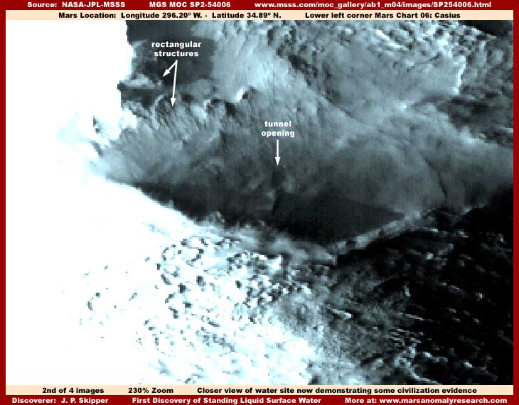
My above second image demonstrates a little closer view of the water reservoir now taken out of the shadows and enhanced for clarity as well as demonstrating a small minor amount of civilization evidence pointed out with arrows and same as originally reported. Here you can clearly see (as much as is possible in this lesser quality satellite imaging) the flat level translucent nature of the water surface. The liquid water surface should be fairly obvious to most, so I'm not going to further mess with the evidence visuals by putting identifying text labels on it.
By the way, the strong light color glare in the left field of the image is a result of my having to considerably lighten the image to bring this site out of the dark shadows seen in the first image. In the process, this already lighter color area increased in lightness and glare.
You should probably also know that, when this discovery was first reported by me in the media back in the midyear 2000, there were a few detractors complaining that I had distorted this evidence creating an illusion of water and they offered proof of this with their own imaging showing their own version of the "true" look of this site. I don't know whether any of these were intentional disinformation specialist or just misguided individuals, but I don't want those attempting to legitimately check behind me now to fall into the same trap of inexperience and ignorance they fell into.
You see, at the official MSSS website links, there are three strips to choose from. The first listed is a faster loading but lower resolution JPEG strip while the second listed is a better resolution but slower loading GIF strip and both are sinusoidal (angled) projections. In comparison, the third listed better resolution but slower loading GIF strip is straight oriented. The problem is that the first two official strips provide a flipped view exactly opposite of the third official strip I used. The evidence is highly distorted in the first two strips but these people were not knowledgeable of this and insisted on using the first listed faster loading JPEG strip for their speed of loading convenience. In their inexperience, when their results didn't match mine in looks, they went right to blaming me for the distortion they experienced rather than investigating further by checking their data sources and their own processing where they would have discovered their mistake. Like many, they just assumed that NASA, JPL, and MSSS would get it all right and would not be offering any flipped views and therefore it must obviously be me causing the problem.
However, official positions and data are not by any stretch of the imagination free of problems. In fact, as I came to find out, it is very risky to assume anything or take anything at face value with regard to official data sources. For my investigations, I to started with the first two strips but quickly saw the distortion and moved on to the third strip. Further, be aware that the third strip is after all the only official strip orientation officially used in the raw science data that the scientists see, not the first two strips. I made my discoveries and drew all of my evidence from this third listed official straight GIF strip. So be forewarned that any attempt to check behind me to validate and confirm these discoveries as presented here in this report must be done in this third listed official undistorted science data strip or results will be very problematic.
In addition to the presence of the impossible standing liquid surface water, also of large significance here evidence wise in my above second image is the dark tunnel opening evidence pointed out by an arrow and text label. If you will look closely, the rock looking formations in the water out in the open in front of the tunnel opening demonstrate a clear path through them the exact same dimensions as the tunnel opening. Obviously, it is likely that something comes out of this tunnel and down into the water. This is very telling and highly probable civilization evidence.
You should also be aware that, even though this water site appears fairly normal size, this is an illusion. The truth is that this scene is very distantly seen and all this water reservoir evidence is huge in size including the immense tunnel. A tall massive building could sit in the mouth of this tunnel opening, not touch its sides or top, and look very small within its circumference. I can't impress on you enough the importance of understanding this size scale factor because one of my discoveries was that image tampering present in the official imaging not only concentrated on covering civilization evidence, it is also covered terrain detail that would allow a true interpretation of comparative size scale in the image.
In other words, although this water site appears to be a relatively regular large size waterhole or reservoir we might be familiar with, including the tunnel opening, the true size involved here is actually tremendously larger than that. It is via such skillful and subtle manipulation of size scale perception that smaller scale civilization evidence may not be noticed at all or be seen but not recognized because of the tiny size and therefore overlooked and passed over. Tricky but effective.
Also, although it can't be seen well here, very close examination reveals that there is a fair amount of tiny rectangular structure evidence in bits and pieces all around the immediate area of this water site. Mostly its tiny bits and pieces left peaking out from the extensive foggy image tampering that extensively covers almost every bit of but not quite all of the terrain around this reservoir. This tampering application is especially thick in the terrain on the back side of this reservoir site extensively covering up something there. I'm not going to stress this lesser civilization evidence here as much as I did previously because there is much more powerful civilization evidence lower down in this strip and I'm reporting that separately under new report #051.
Also some have wanted me to claim this site by naming it. I just couldn't consider this because I'm satisfied this pie shaped water site is not natural but is a giant artificial water reservoir created to serve some of the civilization needs in this area that is mostly hidden by the tampering. Think of it, if there are ever working relations established with those on Mars, what would it sound like to have someone's municipal water supply basically in their back yard named after some Earth guy. I suspect that they may well think that was just a tad presumptuous and I would correctly be the object of their derision. No, I don't think so.
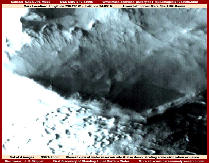
Meanwhile, the above third image demonstrates as closer unobstructed view of the water reservoir as I can get without pixelization problems beginning to become an issue. Here you can see back wall vague land forms but the important thing is to note that they extend underwater as seen through the water flat level but clearly translucent surface. This is also mixed with above water forms reflecting on the water surface. Unfortunately, both of these aspects of the evidence are very vague because some light faint blur image tampering has been put on them just enough to obscure them but carefully not enough to significantly obscure the water itself.
This latter factor in the evidence confirms my belief, as I have discussed a number of times in other reports and as has since be reinforced by other subsequent discoveries, that originally there was an agenda within the secrecy types to try and make the MOC water evidence as accessible as possible to find for those investigating this data. As I have reported elsewhere, there are even strips where the image tampering has destroyed the water evidence too much in hiding civilization evidence and then tampering has been used to try and recreate the water site. Unfortunately, while they could perhaps control the data appearance to some extent, they can't make people see what they have come to believe to be impossible. Just shows you can't have your cake and eat it to.
Although heavily obscured with the fog image tampering, you can still see here at this closer zoom factor some rows of rectangular structures on the left side just above the reservoir water in the background with only their row tops peaking out of the foggy tampering. Take special note of the look of this evidence as you will see much more of this only much better in the separate report #051 titled "Mars Super Metropolis" and you will want to recognize and compare the similarities. Also, in the mid to right foreground area immediately below the reservoir, is more tiny tampering obscured and therefore vague rectangular structure civilization evidence.
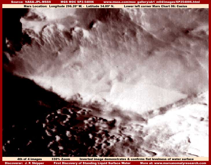
I've included the above fourth inverted image to demonstrate better the flat level clearly well defined water surface from a different perspective. Note to that the foggy fuzzy featureless image tampering is also displayed better in this view. This different inverted view also helps a little in demonstrating the vaguely seen rows of rectangular structure tops of civilization evidence in the upper left quadrant of the image better that is sticking a little out of the tampering applications there as well as some rectangular structure evidence in the left dark foreground area.
Finally, before closing, please again note that I inferred important civilization evidence in the previous version of this report but did not actually include it in my previous reporting. Again, my thinking back in those early mid-year days was that combining very strong water and civilization evidence together at the same time in my reporting in the media at that time would cause too many problems in too many viewers minds. So, I basically left the strongest civilization evidence out of my first presentations of this report. However, this omission is now corrected in my separate report #051 titled "Mars Super Metropolis." Take a look at it and remember that it is civilization evidence drawn from the same official strip used here.
Look at both reports carefully and compared the row upon row of civilization evidence in report #051 with the few lines of rectangular structure tops just barely seen sticking out of the foggy image tampering in my above third and fourth images here in this report. You should be able to see the similarities well enough, even if the evidence is very tiny and mostly obscured here in this report except for the huge tunnel opening.
In my now much more experienced opinion, the real truth is that this water site is not a natural water hole but rather a huge artificial constructed pie shaped water reservoir sitting in and serving a tremendous extensive metropolis. That metropolis is mostly hidden under thick and effective image tampering applications in the environs immediately around this water site but some incredible major parts of it are revealed lower down in the strip as represented by the evidence presented in my #051 report.
SUMMARY POINTS:
(1) ... The liquid surface water presented here is hard evidence supported by official science data.
(2) ... Liquid surface water unprotected in the open undermines official explanations as to Mars conditions.
(3) ... Liquid surface water unprotected in the open undermines the official temperature science data itself.
(4) ... Tunnel features are very suggestive of artificiality and therefore of civilization evidence.
(5) ... Rectangular structures in reports #002 & #051 together confirm strong civilization evidence.
DOCUMENTATION:
The easiest way to check behind me to confirm and validate this evidence in the official science data is to access it via the MSSS website link below.
http://www.msss.com/moc_gallery/ab1_m04/images/SP254006.html
There are three browser compatible strips available there. The first is a faster loading but lesser resolution JPEG strip and the second is a better resolution but slower loading GIF strip and both are sinusoidal (angled) projected. However, be warned that both these first two strips offer only a very distorted flipped view of the evidence. To match my results here, you will need to use the third listed slower loading but better resolution straight oriented GIF strip. This is really the official orientation same as used in the raw science data strip the scientists see and it offers a much better undistorted view of the evidence.
In this third listed GIF strip orientation, the water site evidence is located about 60% of the way down from the top of the very long strip. You should look for the elevated bluff system same as appears in my first image at the top of this report to locate it. Remember, in the distant official resolution the water site is in shadow, so graphics software will be needed to lighten, zoom in, and clarify.
, Investigator