
THE REAL SMOKING GUN AS
TO LIFE ON MARS
Report #001
06/23/00 (orig post) - 12/31/01 (1st revision) - 06/03/03 (2nd rev)
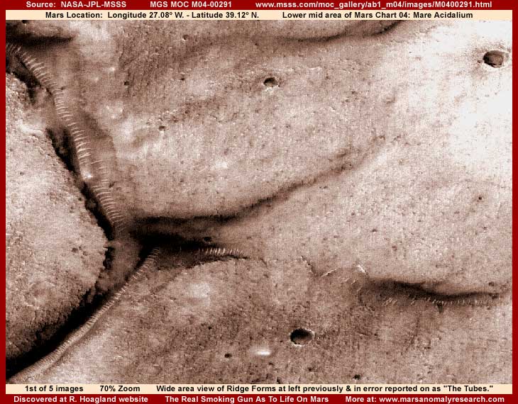
In the above first image here is the powerful anomaly evidence drawn from the MGS MOC M04-00291 official science data strip that started it all for me in Mars exploration. As some may remember of my story, I found this evidence first at Richard Hoagland's website within a couple of days of it being posted there as one of the first discoveries to come out of MOC imaging and within a couple of weeks of the first batch of official images being released. There it was essentially buried behind multiple layers of other much lesser imaging where few viewers, in my opinion, would have an opportunity to see it without some determined digging to reach it as I had done. I could not understand how such powerful evidence could be treated so lightly.
Why? Because the instant I saw it, I knew that I was not looking at natural geology but was looking at extraordinary life evidence of some kind on Mars where it is officially suppose to be hard frozen, dry as dust, and dead as can be. Clearly, by the process of elimination, the long lines of many parallel short ridges seen here and many places elsewhere on Mars have no known parallel in any natural geology familiar to us here on Earth. If no adequate natural geological explanation fits, then one logically has to consider seriously that these anomalies are forms created by life of some kind. The question then becomes what kind of life and for what purpose, not simply passing it off as an inexplicable anomaly as though that was some kind of dismissal label and explanation.
After trying to motivate Hoagland and company to get this incredible evidence before the public better at their website as well in the media and strangely getting no where with them at all, I got fed up and took it upon myself in a one man operation via e-mail to give this hard evidence the media exposure around the world it clearly needed. Obviously, if NASA had reported this mysterious evidence to the media as a major discovery, every major media organization would have dutifully rubber stamped it and reported on it profusely as such but this incredible discovery was of course thoroughly ignored and even resisted by the mainstream media due to it coming to them via a non official NASA or JPL source. Naturally it made no difference at all that this was drawn directly from the science data and easily confirmed in that science data with a simple Internet browser within a few minutes. It really is a pathetic state of affairs with the media who apparently look primarily at the source rather than at the evidence itself.
However, I had expected this and kept applying pressure via media in other parts of the world and it started catching on there. Finally in June, 2000 my material started being picked up and presented at www.sightings.com (now www.rense.com) and a few other places in the USA creating a lot of initial public interest and excitement that was also eventually continued in other media organizations. Obviously, with this limited exposure, my previous comfortable role as a quite behind the scenes lurker or spectator was over with and now changed into direct involvement. Since then, I've made many significant anomalous Mars discoveries, in fact more I believe than anyone else I know of, except of course for those constrained by secrecy orders, nondisclosure agreements, and with careers that can be put at risk.
But, back then I was so new to this including having only limited computer skills and especially no graphics software skills at all. In fact, I had never used graphics software before of even the simplest variety. Basically, I was an insurance investigator with several decades of experience and the important thing that transferred over from that background was a professional objective disciplined investigator work ethic. Also, I came to this out of interest and curiosity with no preconceived prejudices or expectations, which equated to objectivity and I believe that is a good thing in this work. Long ago I learned to just gather, follow, and let the bits and pieces of evidence point the way. I don't get out in front of the evidence trying to filter it through my own set of preconceived ideas and prejudices.
One thing though, having this kind of interest for decades and following along with space exploration for decades, over time I had come to have less and less confidence in the truthfulness of official reporting on this subject. Perhaps this was also partially due to my investigative experience in always questioning information and never taking it at face value. Further, that is especially true when someone wants me very much to accept things at face value and tries to persuade me there is no need to look deeper. The older and more experienced in life that I've become, that kind of "management" of information gets on my radar very quickly because it often means that truth is going to suffer. Frankly, in space exploration, there seemed to me to be far too much of this kind of "management" of information going on.
Then when space probe missions to Mars began to fail completely with some incredibly lame and unbelievable excuses as to why they failed, my suspicion meter started rising. I simply did not believe the official explanations were truthful and suspected the missions of being successful but just hijacked into secrecy. Then there was a lot of initial delay and a determined resistance to releasing the MGS MOC science data despite a clear legal obligation to timely do so. On the heels of this it was learned that one of this nation's most famous and competent super spooks, a Navy Admiral, was essentially chairing the oversight committee of JPL in secret until a high NASA official ousted him and his presence.
Now you have to understand that, contrary to what many may think, the real control of Mars exploration rests with JPL and its partners, not with NASA, who has only general administrative oversight. This made this super spook's control position in secret essentially dominant over Mars exploration that was suppose to be a civilian effort under civilian control a real eye opener for me. When the initial resistance of the MOC system provider to release the science imaging data was combined with JPL and the super spook appearing to go along with and support this unlawful act, this just appeared to me to be another now very blatant attempt to test the straight forward hijacking of Mars exploration science data into secrecy in spite of a clear legal obligation to do otherwise. This kind of arrogance was just too much for me to accept.
So, having never done anything like this before, I got off my duff and became directly involved. After a little research, I learned that Senator John McCain (another Navy man) was chairing the government committee that oversees NASA and space exploration in general and so alone I concentrated on him. At the time he was running against George Bush, Jr. for the republican Presidential nomination and I thought he would be especially sensitive to public knowledge that something like this had happened and/or was happening on his watch. I started applying pressure and only later learned that I was apparently part of a swiftly growing grass roots movement of concerned individuals acting on their own the same as I was applying pressure to various governmental leaders. This movement apparently very quickly impressed the super spook enough and suddenly, without any warning or explanation for their previous position, the MOC provider dumped the first 27,500 MOC images they had been holding back onto the Web and have been adding to them ever since. This of course effectively put an end to the voluntary grass roots movement. Within several weeks, this particular highly anomalous evidence from the M04-00291 strip showed up out of that first dumped batch.
Because back at the beginning I had no graphics software skills or even the software itself, I at first had to depend on the imaging of others. That meant that I could not zoom in at all to examine evidence like this in needed closer than officially provided detail or do any clarification work and therefore had to draw conclusions from other people's imaging. Handicapped in this way, in my initial comments on this particular anomaly site, I tended to follow the basic interpretive lead of Hoagland and company and their speculation that the anomalies were glass tubes. If you will look closely at the images here in this report, you can see in some of them that the ridges appear to be a bit contoured in shape. This is likely an illusion of image tampering but at the time, in my inexperience, I did not fully understand this.
In my inexperience back then I even put forth additional speculation that these might be organic grown structures. I was thinking in terms of some kind of underground hollow root type growth system where the terminating end of one growth appeared to ride up on and rest on top of a lower level one. I was thinking in terms of an organic system like this designed to follow water underground and secure it from evaporation on a dry world with a very thin atmosphere where evaporation is a major problem. Unfortunately, I apparently wasn't clear enough about this distinction and the media picked up on this as "worms" and then tried to stick that high drama sensational identification to my interpretation of these anomalies.
Further, after dragging their heels so bad in the beginning, Hoagland and company quickly jumped on the media band wagon including readily promoting the sensationalized "worm" concept to at their website in addition to their original glass tubes concept. I found this kind of wilder speculation very strange because I felt that they were far too experienced well beyond my capabilities at satellite imaging interpretation to make what I increasingly was coming to recognize even back then was a clear mistake. To me this seemed more like direct intent to associate this evidence with outlandish cartoon grade "Z" movie characterization claims and therefore marginalize this as real evidence in viewers minds. In fact, from that and the previous initial reluctance to promote this evidence to the public at all, I grew increasingly suspicious of their motives.
In any case, even though I had no graphics software skills at the beginning, I did have motivation. Also, people were asking me for additional information on these anomalies that I was unwilling to supply without my own direct in depth investigation not associated with the imaging of others. So I obtained the graphics software program PhotoShop and set out to learning it from scratch. Soon the scales were lifted from my eyes and I can't begin to describe to you the vistas that opened up before me as to real truth finally being obtained directly by me as to what is really the situation with evidence on Mars. Further, what I was discovering was entirely different than what I thought I might find and most definitely completely different than any official positioning as to what is and is not on Mars.
While my growing discoveries did vindicate my previous suspicions about the correctness of official information on space exploration, I also began to understand the full magnitude of the complexity of the secret being kept and why this was the biggest and deepest National Security issue of all time. I could now better see how that trusted super spook came to be in his control position at JPL, even if I could not be other than against the blank censorship of knowledge I suspected him of promulgating. It also became increasingly clear how far back in time this whole thing reached with its roots in the days of the Cold War that I grew up in where paranoia reigned supreme for decades and the insufficiency of technical defensive capabilities back then apparently dictated serious insecurity in decision making. Don't get me wrong, total secrecy and the ignorance it promotes as currently practiced is wrong and must be corrected, but I could certainly understand how unprepared they probably were to deal with such complex issues back when all this started decades ago.
When I began to gain some experience with the graphics software where I could see better detail than available to me in the imaging of others, I revisited this M04-00291 evidence and began to work out what was really going on here. The very first thing I worked out to my satisfaction was that these anomalies are not tubes or organic type evidence nor anything to do with those concepts. The humbling fact actually turned out to be that these anomalies that I have labeled "Ridge Forms" are representative partly of geology and partly of life. These revelations caused me to look aghast at my original inexperienced comments. So I finally got around to posting a revision report on 12/31/2000 backing away from some of my original speculation that was just influenced too much by others. This time I reported what I am satisfied is really the truth with these particular anomalies based solely on my own investigations.
Since then I now have years more experience and proficiency at Mars exploration having looked at many tens of thousands of Mars satellite imaging. So, I'm revising this report again here for the second time to reflect that steadily growing interpretive experience as well as bringing this reporting and imaging in line with my current reporting and larger better imaging style. Also, I'm adding reporting for the first time in this revision direct liquid surface water evidence that I was originally reluctant to include and held back reporting on.
You see, my second report on the heels of this first one of my discovery of the first standing liquid surface water on Mars was also carried in the media before being posted as they are now on the Web. Where this first report was primarily about life, without the water discovery it very importantly did not necessarily really challenge existing science data and therefore belief systems. This made it more dismissible and therefore a bit more palatable to traditionalists who have swallowed the official party line hook, line, and sinker.
On the other hand, my second report in the media on standing liquid surface water upset the apple cart by directly challenging the very basis of official positions and what most people, including most scientists, thought they knew unquestionably for certain about Mars. You see Mars is suppose to be very hard frozen with temperatures not only cold enough to freeze water 3-5 times over but cold enough to freeze CO2 as snow right out of the atmosphere. Obviously, if true, surface water in a liquid unfrozen state would be quite impossible.
Although my intent back then was simply to report this water site as a straight forward discovery, liquid surface water evidence was interpreted by many as too challenging of the status quo and so it stirred up quite a bit of furor. Since I was new to the business of liquid surface discovery on Mars back then and bucking the whole world with such information, I simply was not as confident then as I am now about my liquid surface water discoveries. I also considered that all the furor over the water would detract too much from focus on and understanding the complexities of the "Ridge Form" anomalies and the fact that they demonstrate life that I was trying to communicate, even though they and liquid surface water are closely related to each other. So I just avoided the subject in my first postings of this report.
Note that I later also revisited this Ridge Form subject in my #18 supplemental 3/29/2001 report titled "The Tubes: Natural Geology or Life?" found HERE. In that report I presented yet more evidence trying to convey again what the "Ridge Forms"are and what they are not. Make no mistake about it, regardless of others trying to push this subject toward the sensational and ridiculous in hidden agendas to marginalize it in most viewers heads, this is very powerful real world hard evidence of life of some kind on Mars that deserves very close objective consideration.
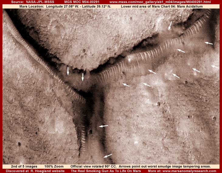
So, with that background in mind, let's get on it. Where the first image here at the top of this report provides a broad wide more distant official view of the anomaly and its associated neighboring terrain, the above second image demonstrates a little tighter view limited to just the anomaly site itself. To get this and fit it all in, I had to rotate the image 90º counter clockwise but the view still matches the official 100% resolution and adds no apparent distortion. Any true slight distortion seen anywhere here in this imaging is actually the result of the science data strip itself being subjected to stretching at official level as will be further explained below.
In the above second view, note the contoured appearance of the main ridge anomalies on the right. You can see better how a terminating end of one "tube" coming from the right to left seems to ride up on top of and over lay another tube coming from left to right under it. However, this is strictly an illusion created by layers of foggy, smudgy, featureless image tampering in the terrain out from the anomaly (lower right quadrant of the image), right near ridge line base areas, and up in between the many narrow light color parallel ridge lines. Much of the worst of the tampering applications are pointed out by the multiple short arrows in the image. The terminating "tubes" end appearance is actually a massive powerful light source sitting on a down slope embankment partially obscured by tampering, which helps create the terminating end illusion.
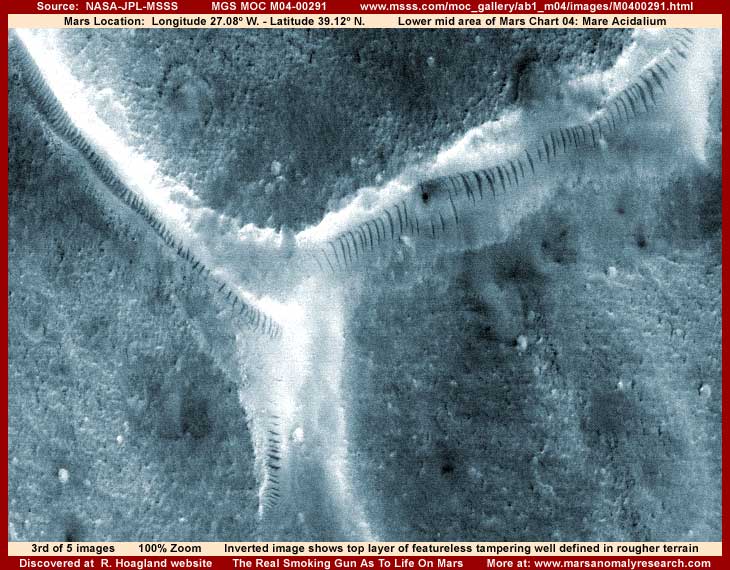
The above third image is actually my second image above, just inverted. I've included this inverted view because it better demonstrates the image tampering with its lumpy puffy like clouds look and texture and the fact that it is essentially a featureless application with no geological detail in it clearly having no parallel in natural geology. Natural geology has at least some detail in it but this soft fluffy featureless look is a dead give away that this is not true terrain geology but artificially applied covering applications. The demarcation lines between the layers of tampering can better be seen here to. The lightest colors are the last tampering layers applied at slightly closer resolutions and you can better see here how it extends in continuous smudge not only around the base areas of the ridge lines but actually up between them hiding everything there.
The fact is that most of the surrounding higher detail appearing terrain further out has a number of layers of tampering in it to so that little true geological detail can be seen there either. It is just not as obvious as the final applications because it is a little darker color and provides a little more ground mimicking detail because it was applied at much closer resolution and then back off to be seen at this more distant view. When one looks very close at maximum zoom in these higher detail appearing areas, there is still little recognizable natural geology seen, just much smaller "puffs" that mimic geological detail. About the only thing that is real here is the ridge lines themselves sticking out of the thickest part of the tampering applications.
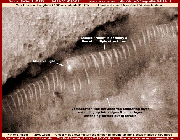
In the above fourth image 250% zoom closer more telling view of the main portion of the anomaly, still with the rotated 90º counter clockwise view, you can see this featureless image tampering better. Note how it extends up around and in between the ridge lines hiding everything in these areas including parts of the ridge lines themselves.
So why even bother talking about this image tampering business at all? First, it must be understood that image tampering is not just there, it is there for a reason. Of certainty that reason is to hide evidence and prevent knowledge of something known in secret to others but which they do not want to share with us and/or are afraid to share with us. The real question is what could be so important on another very distant world that they would go to this much trouble and expense to hide it? Why would anyone spend in secret many millions of our tax dollars hiding natural geology (rocks), water, or even long dead civilization evidence? There is no threat in this subject matter to raise National Security and therefore secrecy issues, so logically this just makes no sense.
However, if you add consideration of live active civilization evidence into this picture, especially civilizations more technologically advanced beyond our own, suddenly things begin to fall into place and the secrecy all starts making more sense. It also starts making more sense why official decision makers continue to insist on conducting Mars exploration with essentially covert observational technology and stonewall the growing dissent and pressure among a significant portion of the science community who believe that planning manned flights to Mars as a frozen, dry, dead world should be the priority.
In my humble opinion, sending manned flights to Mars staffed with people ignorant of and unprepared for what is really on Mars is a very bad idea in the extreme fraught with high risk for our whole world. Alternatively, do you want manned missions to Mars subject to potential first contact situations to be picked exclusively by and staffed with people hand picked only by and prepared by secrecy types who may claim representation of us all but who at the same time are not the least bit interested in public knowledge or input? Do you see anything wrong with such a picture?
How well this image tampering is done up in these tiny spaces between the ridge lines demonstrates to me that this kind of tampering was done at much finer closer resolutions than officially released. That in turn confirms that such closer resolution imaging does in fact exist somewhere no doubt in secrecy archives. Further, it means that someone is looking at this kind of evidence not only without the image tampering obscuring detail for them but also via much closer resolutions providing excellent information far beyond that available to us. Logically now, do you honestly think that competent military super spook chairing JPL with its already very heavy military ties would send modern satellite camera systems on something as costly as the MGS MOC mission to Mars that are not even up to the satellite imaging resolution limits available to the military in the 1970s as evidenced by the poor quality official imaging now being released to us?
A true understanding of what is really going on in this scene in my above image cannot occur unless true size scale is also figured out. That isn't easy to do because what they have left us with, after all the tampering hiding not only whatever evidence is around and between the ridge lines but also any visual size frames of comparison reference, creates the illusion of a relatively normal size scale. However, in the upper center area of the above image, note my arrow pointing to a sample of one of the ridge lines to the right of the massive light source. I've seen a lot of this kind of evidence now and, even though this is very distant and poorly seen with individual detail tending to merge together into a continuous chain line, careful examination reveals that this line and a few others are tending to separate out into a line of multiple tall structures rather than any kind of continuous natural geological ridge. I would have increased the zoom further to see this better but pixelization would have started being an issue.
Here's the deal. I've come to learn via increasing experience that some civilization structures on Mars consists of lines of densely packed high rise structures that look very much like the buildings I suspect they are. There often seem to be parallel lines of light color buildings with darker color and often somewhat shorter buildings in between the lines. A little light color over saturation and distancing of the resolution makes the more reflective light color lines of structures blur and merge together mimicking and creating the illusion of these ridge lines. Sanitized as life evidence in this way, that is why they are left out for us to see. However, this technique is inadequate to hide the darker colored structures enough and they require this additional direct image tampering applications of foggy, smoky, smudgy, cloud looking featureless applications. If done at very close resolutions not available to us and in many little tiny individual covering puffs and then draw back to a distant view, the application is flattened out causing it to mimic natural small terrain detail better. But, if done at not as close resolutions where the distancing technique is not as effective, then the result is more this obvious foggy, smoky, cloudy featureless look.
Although the detail is too distant even in the above 250% view and therefore too small (by intent) to be conclusive, I suspect that we are looking at lines of buildings down a relatively short down grade slope but a slope system long in length. I am satisfied that shallow water overflows down this slope from a catch system at the top of the slope hidden under the darker image tampering in this locale. At the bottom of the slope unseen is probably another water catch system. The very heavy degree of image tampering in this area probably means heavier civilization evidence because I've learned that this is what the tampering always deals with the most. In other words, the presence of shallow liquid surface water flowing down a slope is the key factor represented by the Ridge Form visual evidence.
If these are high rise civilization structures in lines as it appears, then this gives us a better more reliable idea of the true size scale here in scenes like this than any official statistics. Remember, anyone who is of a mind to alter the visual data via image tampering as evidenced here would have no compunctions about altering the statistical data as well to fit and support the visual tampering. With that caution in mind, the anomalies seen in this strip are actually much more distant than they at first seem and are therefore much larger than they first appear. For example, something the size of a single large high rise building would not even be a tiny visible speck in the official 100% views here. That kind of comparison is a real wake up call as to the true huge size of the anomaly scenes we are looking at here and the fact that anything we would consider as normal size would be hidden from view. In other words, all we can really see here in this site are objects of a really huge size scale.
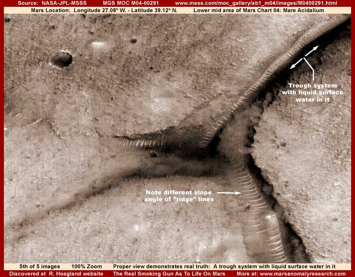
This brings us to the above fifth and telling last image in this report. This is the liquid surface water evidence that I left out of my earlier reporting. This image shown at 100% official resolution is flipped vertically and horizontally from the officially presented view of this strip as represented by the first listed JPEG and second listed GIF sinusoidal (angled) official science data strips at MSSS as well as my first image at the top of this report. However, be aware that the third listed straight oriented GIF official science data strip has this orientation providing this view. So this is technically an official view as well. Remember this because some have gotten confused about the differences in this particular official imaging.
What you're looking at here is a long trough system extending from lower left to upper right located in the upper right quadrant of the above image with liquid surface water in it. It is just one leg of the total system with arrows out in the water pointing each way down its length. The water is dark in this black and white science imaging but, when viewed carefully at good zoom factors, it demonstrates a translucent quality as evidenced where a portion of the ridge covered left slope shoreline can be partially seen underwater just above the head of my left arrow pointing left down the system. This is powerful liquid surface water evidence that cannot be ignored and it provides the key as to understanding what is really going on at this site.
Note how the left shore of the long trough is lined down its length with the ridge lines, just very distantly seen. This is very typical of one of these long narrow type trough systems. Where you see these ridge lines in these long and sometimes snake like patterns, you can rest assured that there is either current shallow liquid surface water flowing down this shore into the bottom catch system with the ridge lines defining the height and length of the downward slope. The bottom line is that seeing all this Ridge Forms down a slope evidence is the clue that confirms you are looking at a liquid surface water site on Mars whether the water can be directly seen or not.
There are many of these Ridge Form covered slopes all over Mars and recognition of the presence of this type of surface water evidence requires an understanding of this. Don't worry, if this is not reasonably apparent to you now in this particular evidence, it will be by the time that I release the bulk of the liquid surface water evidence that I have been holding back and you've gained more experience with respect to recognition of these sites.
On the other hand, the long dark line in the lower right of my image down the other leg of this system that is also a part of this total complex does not directly visually demonstrate water and should not be mistaken for that. Now don't get me wrong, I'm satisfied water is there, but it is hidden by dark and lighter color image tampering applications in this area probably primarily trying to get rid of civilization evidence in that locale and unsuccessfully trying not to mess up the water visuals. Early on I came to understand based on this satellite imaging evidence that there was apparently originally an agenda within the secrecy types to try to enable researchers to find water on Mars in the MGS MOC data and the result was that many sites not associated with dense civilization evidence were not tampered with or minimally tampered with. I've even reported on water sites that were damaged as evidence via tampering and then more tampering was later used to try to recreate them clearly reinforcing this concept.
Also, at this site, remember the shape and pronounced looking curvature of the ridge lines seen in my second and fourth images above? The ridge line raised curvature look in those images was a strong factor making this anomaly evidence look rounded and segmented in appearance creating the illusion of the so called "tube" look while reflections off of the shallow water created the translucent "glass" look. However, note the lower arrow in my above fifth image pointing at this same contour area of the anomaly system. Now you can clearly see that these same ridge lines in this orientation take on an entirely new and different look, one more conducive now to the slope concept with no suggestion of a raised rounded form.
The reality is that either view probably does not exactly represent full truth in the visuals because this entire strip as released has been subjected to some stretching at official level before being released. For those interested, proof of this stretching can clearly be seen in the elliptical shape of craters and pits elsewhere in the official strip that of course should be round. This stretching may very well have influenced the visuals of these many parallel ridge lines causing them to be a bit exaggerated in curvature and reverse curvature in either view orientation.
You should be aware that finding flipped views as well as stretched strips not identified as such are common in the science data and this never seems to be caught in any formal peer review process that is suppose to go on before this data is formally presented for most scientist and the public to see. What does that tell you about the peer review process? Further, the frequent flipping in the earlier MOC imaging most often involves the last listed straight oriented strip or strips. In this particular third listed official view and as you can see in my above fifth image, it enhanced being able to identify the water site here and may even have been why it was done in this particular case to encourage its discovery. I've seen this in other strips involving water. However, much of the time such flipping often increases obscuring tiny size evidence, which often means civilization evidence, because any tiny size evidence is greater impacted by distortion.
I can't conclusively tell you the true reason why this flipping is done but I do have my suspicions. For example, the straight strips are the ones used as the primary science data reference images, including at PDS and USGS where scientists encounter them the most, not the sinusoidal or angled view strips that the general public often sees at MSSS. Further, many scientist, whether working with MOC imaging at MSSS, PDS, or USGS, in order to scan quickly through this data efficiently and especially those using broad band high speed Internet connections, will naturally use the straight strips to scroll through more quickly and efficiently as opposed to the angled strips. With the angled strips, it is slow and very aggravating to vertically scroll down and bit and then have to stop and horizontally reposition and center the image in order to scroll down some more and so on over and over.
Generally speaking small to tiny civilization evidence, should any be missed by distant resolution tampering and direct application tampering, is negatively impacted the most by this trick and amounts to general insurance that little of this kind of evidence will be noticed. For example, my #29 report of the "Huge Nozzle Shooting Liquid Spray" demonstrates a very obvious and huge 3-D nozzle object clearly casting a thick bodied liquid spray and shadow. This orientation is in the first two official angled strips but the straight strip with its flipped orientation shows this anomaly as only a flattened single dimensional object and this is the view most scientist would have seen. So you can see how scientists would have and did miss this incredible discovery.
Basically, in my experience, official flipping seems to impact water presentation positively and civilization evidence negatively. This is just one of the many ways information and therefore perception is manipulated and things not wanted to be seen can be obscured.
The bottom line here in this discovery evidence is first the presence of quite impossible shallow liquid surface water flowing down slopes and second opportunistic life of some kind positioning itself on those slopes and taking advantage of the water in some way. Because of the distant poor imaging resolutions provided, I can't be conclusive enough about what kind of life we are talking about here, even though I obviously have my suspicions as indicated above. However, because the Ridge Forms dynamically grow on these slopes associated with water as clearly demonstrated in my experience with a great deal of other similar imaging, I'm well satisfied at least that we are talking about dynamic living life here of some kind. That means this evidence continues to most emphatically be "The Real Smoking Gun as to Life on Mars."
SUMMARY POINTS:
(1) ... The Ridge Form evidence has nothing to do with tubes, root systems, or worms.
(2) ... The Ridge Form evidence is life capitalizing on shallow water flowing down a slope.
(3) ... The Ridge Forms evidence may be civilization seen at a great distance.
(4) ... Image tampering is pervasive in this site directly hiding evidence.
(5) ... Image tampering is also pervasive in this site creating perceptive illusions.
(6) ... A trough system with liquid surface water in it is clearly and directly evidenced.
(7) ... Liquid surface water evidence challenges & undermines official science data and positions.
DOCUMENTATION:
To check behind me in verifying this evidence in the official science data, the easiest to access is at the MSSS website link below. Remember that there are two different flipped official views available and it is suggested that you look at both to determine for yourself which is the most realistic for the particular type of evidence being examined. In doing this, be aware that in the official first and second listed strip views, the anomaly site is located in the lower left corner of the strip and in the official third listed strip view, the anomaly site is located in the upper right corner.
This www.msss.com/moc_gallery/ab1_m04/images/M0400291.html link accesses the MGS MOC official M04-00291 science data imaging. The first JPEG and second GIF sinusoidal (angled) strips work and have the same orientation represented in my first image at the beginning of this report. Note that these two views present the anomalous objects well, albeit with an outer contoured appearance, but distort the direct water discovery evidence into near unrecognizability, which indicates that this view is probably the least realistic. On the other hand, the last and third straight GIF strip works and offers a opposite official flipped vertical and horizontal view that alters the view of the anomalies to a different look and gives a much better proportional view of the liquid surface water system. It should be noted that this last listed third straight view strip is also the orientation used as the raw science data for scientist to review.
, Investigator
![]()