
UNDERSEA MYSTERY-1
Report #223
September 10, 2012
Joseph P. Skippper
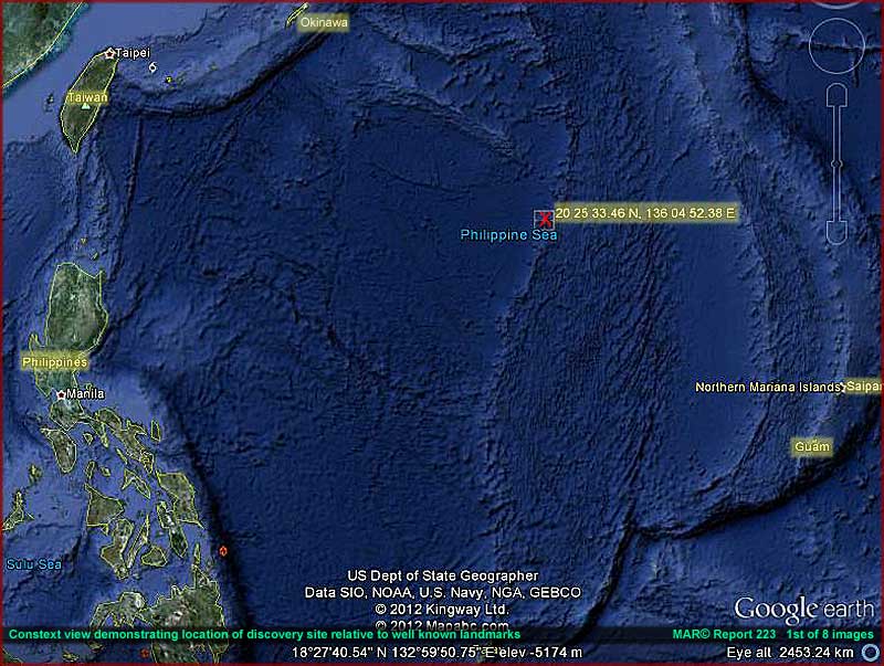
In the above 1st image the red
"X" and its highlighted coordinates
mark the evidence location as well as the type of Philippine Sea underwater
terrain it is located in. Note that this location is basically in the middle
of no where well out east of the Philippine islands and Taiwan and northwest
of Guam. All are familiar names to those versed in WWII information.
Note also that it is located on an elevated ridge system that forms the eastern
boundary of a deep water basin that goes down west into what appears to be
an abyssal plain extending west toward the Philippines. You should know that
this whole area is associated with the northern part of the Mariana Trench
system. The deepest part of the Mariana Trench known as Challenger Deep is
in the dark narrow area immediately south of the island of Guam in the image
lower right corner.
Understanding ocean bottom terrain characteristics is important to understanding
the evidence site here and its potential. In the open ocean deep there can
be sea mounts that are known to fishermen even from ancient times. Sea
mounts are nothing more than mountains or mountain ranges on the ocean
bottom the tops of which may come close to the ocean surface but not breach
it. If the top does break the surface creating exposed land, from a mariner's
point of view it is of course known as an "island."
Because of their elevated mass, sea mounts can dramatically effect water currents
swirling around them and that can attract concentrations of living creatures
such as fish, whales, etc. and thereby of course fishermen who sometimes try
to keep their locations secret from their fishing competitors. They may even
spread rumors about the dangers of fishing around them to help keep others
away. As you can see in the above image, this evidence site is right on and
part of a elevated mountain ridge system oriented north and south extending
south from Japan.
It would not be unreasonable to anticipate that any sea mount in these Mariana
Trench system depths might be accompanied by others nearby along the same
ridge system.
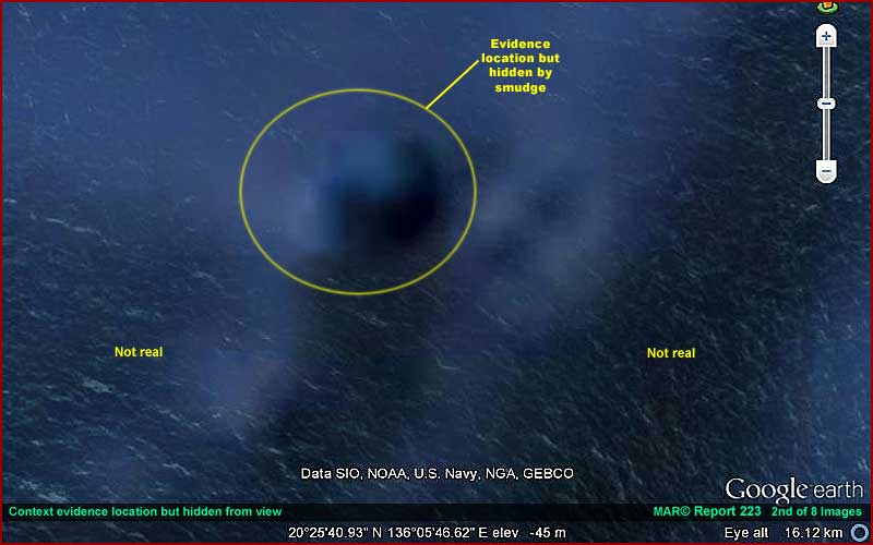
The above 2nd image provides a
closer view of the evidence location site. However, as you can see, there
is nothing here in this view to really see. The site itself is hidden by concentration
of smudge treatments within the yellow circle. Further, The rough textured
background you see extending around and further out from this spot where I
have put "not real" labels is just
that, not real. It is some form of very advanced image tampering covering
and hiding what otherwise might have been seen in this area.
What is incredible from my research point of view is that we are suppose to
be looking at fixed satellite imaging. Yet this textured background moves
and sways back and forth and from side to side as though attempting to mimic
a major field of kelp or some other vegetation fixed to the bottom moving
in response to constantly shifting water currents. It immediately comes to
mind that a constantly shifting and moving false background like this would
be very hard to nearly impossible to defeat graphically and is a really powerful
obfuscation tool.
Worse, Google Earth has massive amounts of this type of obfuscation all around
its Earth globe and especially in suspect places where someone like me would
want to look. In fact, for a researcher like me, its presence suggests that
something may be hidden in the areas it appears in and draws research attention
for a closer even if often futile look.
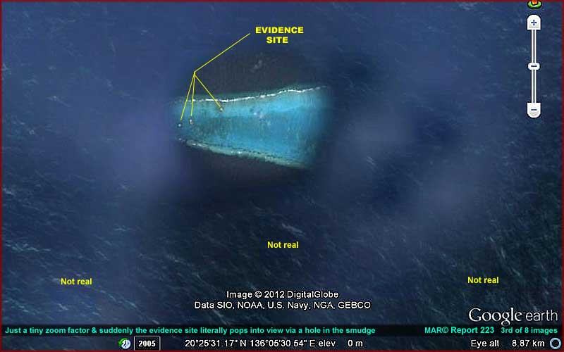
In the above 3rd image just a tiny
ever so slight amount of increased zoom and presto what you see above in image
#2 literally pops suddenly into view like a hole in a closed door. At first
the evidence site appears to be a typical shallow atoll sticking out of the
water but closer inspection reveals this is actually all submerged underwater
and remember that this site is a part of the Mariana Trench system which also
makes it part of one of the deepest areas of the world's oceans.
Before we go in for a closer look at the evidence in the next image, please
note the textured background out and around this hole in the tampering. Note
that the objects (false vegetation) would be impossibly gigantic relative
to the evidence site true size. This demonstrates that one cannot trust the
scale data supplied by Google Earth when this kind of manipulation is going
on in an image.
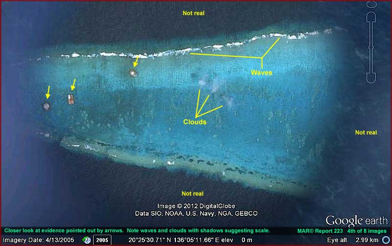
In the above 4th image we're still
looking at the evidence site through the hole in the tampering but now closer.
The white surf on the north (upper) side of the site demonstrates waves moving
from the darker really deep water onto the lighter color shallower water above
this submerged mountain sea mount. Note that the very narrow band of light
color terrain just outside the wave line into the darker water indicates a
quick sharp drop into much deeper water. So we are looking at a submerged
sea mount here coming fairly close to the surface but not breaching it as
an island sticking out of the water.
Note the clouds pointed out by my labeling. Note the dark shadow on the left
cast by one of the clouds. This demonstrates just how distant this scene really
is and again why Google Earth stated scales often can't be trusted.
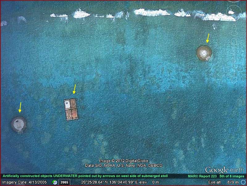
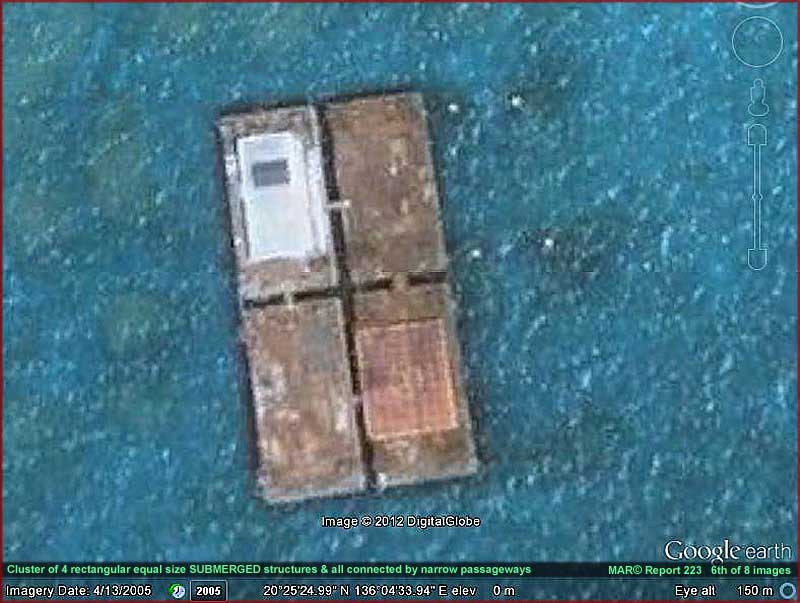
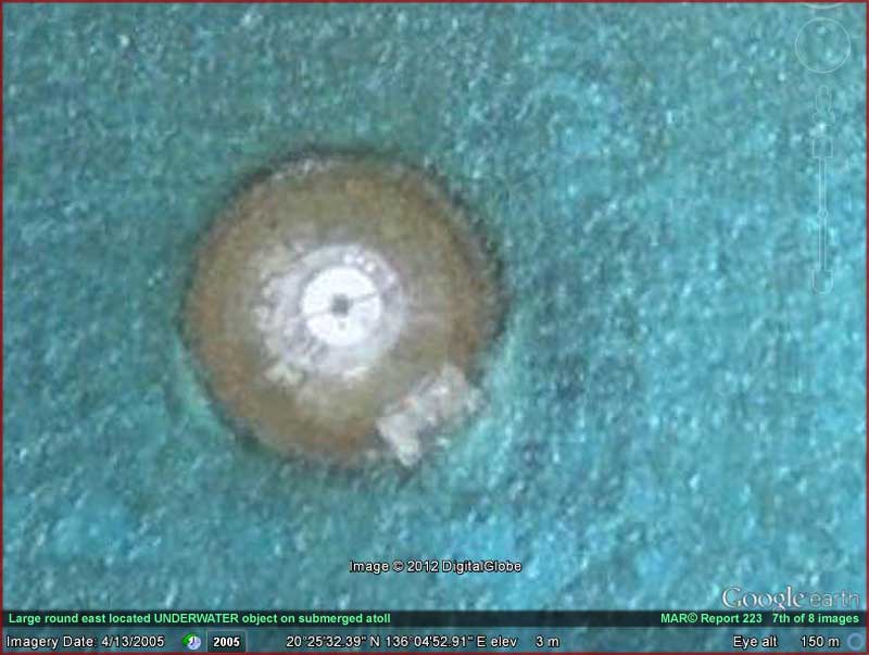
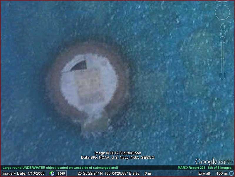
The above 5th–8th images
positions us as close as possible to the evidence before distortion completely
takes over. The structures here all appear to be underwater and I'm thinking
the rectangular four joined constructs may be related to the resin structures
seen in my 2010 on Air Force Dugway land here in the USA and specifically images
#3 and #11-14 in that report.
These rectangular structures together may be presented as experimental marine
habitats of some kind? Maybe but I suspect that they are considerably more
than that located as they are between two round stations that I suspect are
for docking of round UFO/USO type craft as well as perhaps submarines. The
fact that these facilities are located underwater and thereby hidden but in
a shallow location suggests that they may represent Earth technological constructs
rather than something like alien technology.
If you will refer back to the context 1st image at the beginning of this report,
again note that the evidence here is located on an undersea ridge line. In
Google Earth my search does not reveal any other nearby islands or seamount's
along this particular north/south oriented ridge line. However, note that
there is another north/south ridge line parallel to this one located relatively
nearby to the east. That ridge line has some small islands sticking out of
the water all along its length where the ridge mountain tops breach the water's
surface.
It is likely that this particular sea mount evidence site was chosen for this
facility because of its remoteness. It is after all well hidden underwater
here as a ship would have to almost literally run directly across it to detect
it. I would be interested to see what nautical charts of this area say about
it and if there are any warnings posted for ships to steer clear of the site
or if there is a reference to this being a military site and to steer clear
of it for that reason?
As for Google Earth not showing any other sea mounts or islands along the
evidence ridge line, that is not something that can be trusted to be truth
in my opinion. Google is way too "cooperative" with the US military
and other countries as to what they desire to be kept secret for you and I
to trust them in this regard. Even so, someone obviously wants this particular
site to be seen by someone in Google Earth and that's the reason for the tight
little "hole" in the obfuscation image tampering treatments in Google
Earth revealing this evidence's presence.
I suspect they just hoped that it wouldn't be you and I. It is after all very
difficult to find unless one has the specific coordinates and then have sufficient
zoom on the site to reveal it. Any thing less than that will not pop open
the revealing hole (window) and then there just isn't anything there to see
but featureless smudge as shown in the 2nd image here. It seems that confirming
this site's presence at this location in a public program like Google Earth
met someone's requirements.
It is the same with how it was brought to my attention. The site's coordinates
with sufficient zoom factor were brought to my attention in an apparent casual
way by a party who wishes to remain anonymous in Southeast Asia.
The point is though that someone here on Earth appears to have both the technology
and financial commitment (expensive to build underwater) to construct such
a fairly extensive and modern hidden undersea facility out in the vastness
of international waters whether using borrowed alien technology or not. In
this case the evidence has a fair amount of image tampering on it and that
combined with the water depth and waves helps make it very difficult to inspect
and assess its purpose. The round evidence in the distorted closer views is
heavily obfuscated but appears to show some evidence of palisade vertical
uprights at the perimeter edge and that is curious.
I note that the ground on the sea mount top surface around the evidence, although
visually distorted due to water depth, wave action, and tampering, does not
show any marks of construction equipment activity. We can't read too much
into that though because storms passing over this site may have erased evidence
of that via water turbulence if the site has very much age on it.
One thing that doesn't make much sense though is that lower flying aircraft
passing over this site through the years would likely be able to see any round
craft or submarine activity at the site if someone was looking. At the very
least, the basic structures would be quite visible in good weather. Yet, there
it is. It doesn't seem to make much sense to locate such an undersea site
where it can be that easily seen. unless its location is strategic to something
critical going on nearby that we can't see?
That is unless its location is strategic to something important going on nearby
that we can't see and no one wants us to know about? Could this be the case
and it is hidden from us in Google Earth?
ADDENDUM 9/11/2012
Alert viewers
have brought new informative information to my attention on this report which
I'll share with you here and via this link http://en.wikipedia.org/wiki/Okinotorishima.
It appears this site on the Pslau-Kyushu Ridge system
was first visited by Spanish mariners in the mid 1500s and named by them "Parece
Vela" which translates into "looks like a sail." Geological
references apparently still primarily use this designation. It appears the
Japanese may have found it in the late 1800s eventually naming it "Okinotorishima"
or the "Okinotori Islands" translating to "remote
bird islands" and trying to claim it exclusively as the southern most
islands of Japan in the early 1900s.
The site is referred to as an atoll because it is suppose to have had just
five rocks sticking less than 3 inches out of the water with the bulk of the
site submerged even at low tide. The Japanese supposedly started to establish
a presence on the atoll likely more to support acquisition claims to it that
were interrupted by WWII. The story goes that from 1987 to 1993 the Japanese
built round steel and concrete structures as breakwaters to retard wave erosion
at the site. In 1988 they built rectangular structures on stilts as a marine
investigation facility complete with a helo landing pad.
The above Wikipedia article link contains a distant but fairly clear aerial
angled picture of the site showing it mostly submerged except for three
elevated round structures and the tight group of rectangular structures. You'll
note in the Google Earth imaging posted here that only two round structures
are visible in that material. This may be because of the too close encroachment
of image tampering on the perimeter of the site in Google Earth on the west
end of the shallows.
This information would explain a lot of things associated with this site but
not all. For example, after reading the Wikipedia article, why would someone
be so persistent and spend so many millions of dollars from limited resources
on this place unless it has some sort of strategic value to someone that we
can't properly see or appreciate here? Further, why would the satellite images
be so hard to come upon in Google Earth without the specific coordinates and
then once found be so visually degraded that is often typical of covert facilities
making ascertaining details of the evidence so difficult? Surely there should
be nothing worth obscuring on old worn constructions likely abandoned for
long years.
Someone places a high value on this mostly submerged site in a relationship
that isn't readily apparent in any of the sanitized Google Earth visual material
available to us. You must decide for yourself but this old dog is still suspicious
and asking questions.
, Investigator
![]()