
MARS GEOMETRIC EVIDENCE
Report #207
September 11, 2011
http://www.uahirise.org/PSP_008427_1380
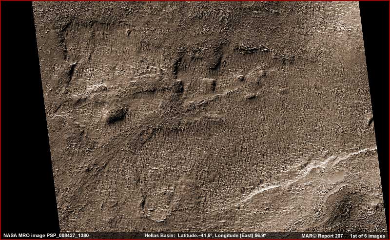
This report has to do with some
very geometric Mars terrain as seen in the 1st image above in the Hellas Basin
on Mars. Now Hellas Impact
Basin also known as Hellas Planitia is
old and the largest unambiguous crater impact depression so far identified
on Mars and one of the largest in our Solar System. The site is located below
the Mars Equator roughly midway in the Mars southern hemisphere at coordinates
42.7º S and 70.0º E. It is thought that this basin was formed by
a large asteroid impact some 4.1 to 3.8 billion years ago.
Hellas Basin is circular and huge at about 2,300 km or 1,400 miles across.
It is about 7,152 meters or 23,000 feet deep relative to the wider area normal
terrain further out surrounding the basin but much deeper than that at 30,000
feet compared to the closer in crater rim material thrown up by the impact.
This suggests that the pressure at the bottom of the depression may be around
89% greater than in the normal surface surrounding terrain.
To the northeast of Hellas Basin is the volcanic Hadriacus Mons complex. The
rising elevation of this volcanic area suggests forming a downhill slope toward
Hellas Basin and sure enough two deep gullies Dao Vallis an Reull Vallis are
present likely formed in the past by surface water flows from the elevated
volcanic influenced area down to the Hellas Basin depression. It is thought
that the higher pressure at the bottom of Hellas Basin would make surface
water presence transient (only temporary) in the basin IF
the temperature there ever got warm enough to melt any water that had flowed
into the basin.
With this geological background and thinking in mind, let's get back to the
basin floor itself. There are many terrain forms around on this basin floor
that puzzle scientists and one of them is the geometric terrain forms so distantly
and poorly viewed in the above 1st image. Now let's take a little closer look
in the next two images below and you will begin to understand why.
http://www.uahirise.org/PSP_008427_1380
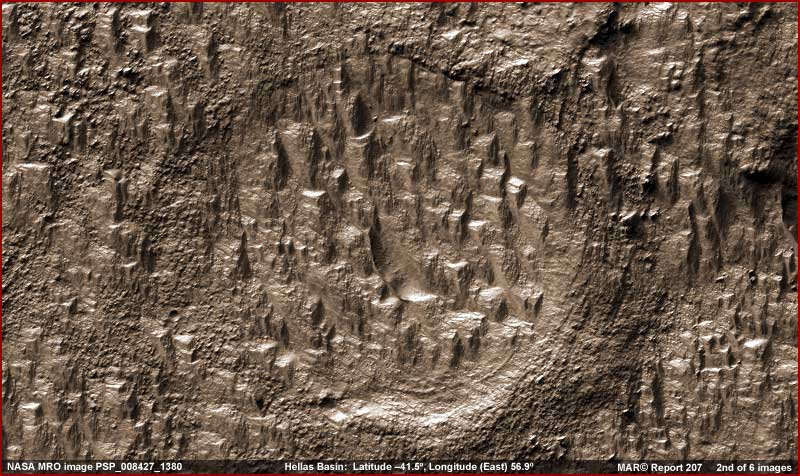
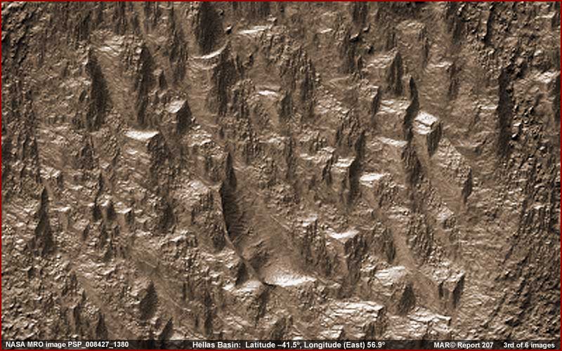
The above 2nd and 3rd images offer
an increasingly closer view inside a smaller impact crater in the basin and
they provide a representative sample of the geometric evidence and how it
looks on average all over the MRO PSP_008427_1380
strip this evidence is drawn from. In the 1st image, note how pervasive this
evidence is over a wide area. It occupies most of the strip like this and
extends well beyond the boundaries of the image strip. There are other strips
confirming these geometric shapes as well.
Also, in the 2nd and 3rd images, note that many of the forms consist of at
least two vertical 90º right angles as well as a flattened horizontal
and rectangular top surface. Note that some of the evidence is large and some
is smaller. Even though this evidence I've selected for imaging here is down
in an impact crater on the floor of the giant basin, this evidence type is
essentially universal and typical of both basin floor impact depressions like
this and also of the basin floor more level terrain.
You should know that apparently primarily because of the evidence of right
angles and flattened tops, others have reported on this as being evidence
of a mammoth city on Mars and that these are its buildings. There have been
YouTube videos made of this evidence from angles that tend to visually suggest
this conclusion. Some presentations are quite effective in this way. An example
is a 38 minute video found HERE
and brought to my attention by Haddads Martial Arts.
By the way, if you access the official science data image from which the visual
evidence presented here was taken at one of the links provided here, you will
note that they have added a graded false blue color to some of the images.
That is because they are pushing a connection between this evidence and Carbon
Dioxide ice. Rather than continue this psychology or present the evidence
in plain black and white with its limitations, although the blue color may
be more attractive, I've added my own false sandy raw geology color to make
the visuals more visually comfortable to the eye and enhance detail a bit.
Just remember that none of these colors, theirs or mine, is necessarily accurate
and that must be taken into consideration.
http://www.uahirise.org/PSP_008427_1380
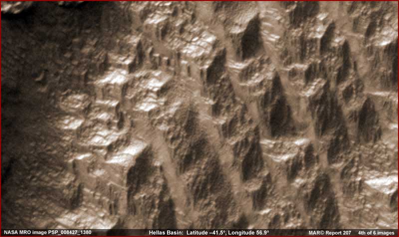
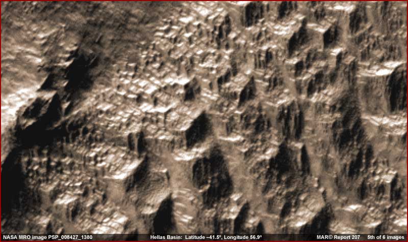
On the other hand, in the above 4th and 5th images from another representative site in the strip, note the clear stepped or tiered effect going down on the more massive forms forming terraces. Note the object in the upper right corner on the flat top surface in the 5th image. Note also the great many crowded smaller geometric forms extending from the lower left bottom area to the upper right top area left of center in the 5th image. Now take a look at the last 6th image below.
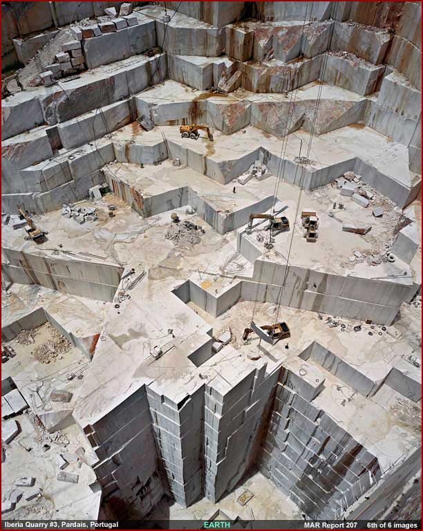
http://www.edwardburtynsky.com
(click on "quarries")
Note the above 6th image of an
Iberia tile surface mine #3 in Portugal here on Earth
and its similarities to the Mars evidence with respect to geometric forms.
Now with these visuals in mind, here is my opinion as to what we are looking
at on Mars. Maybe we are looking at some strange civilization structures but
more likely it is something else that is still equally indicative of civilization
evidence.
I suspect we are looking at a great many Mars surface mining quarry sites
that have likely been in operation for many hundreds or even thousands of
years with the mining spreading and growing more and more extensive over time.
It may be that someone has been mining stone here but more likely it is water
ice itself that poured into the basin in the ancient past and which has been
covered and protected in colder planetary periods by accumulating soils within
and on top of the ice in layers. They mine this hard soil infused ice just
like stone in the Earth quarry example. The mining simply follows the ice
thickness and quality.
It is also possible that someone has moved into the quarries and made areas
of them their home over time and that this is represented mostly by the smaller
geometric evidence that tends to accumulate in the open on the tiers flat
level surfaces. This type of evidence is especially prevalent in the 5th image
left of center. I suspect that the Mars visuals would be more conclusive in
this regard but image manipulation cutting resolution and creating blur on
edges has compromised this particular smaller scale evidence. It is also possible
that these quarry sites in many places have served their purpose in the past
and have been long abandoned collecting a lot of collapsing rubble over time
on the flat surfaces.
The scientists are having so much trouble putting this together and identifying
some of the terrain forms like this on the Hellas Basin floor simply because
they just can't entertain the idea and effect of civilizations on Mars and
other planets in our Solar System. They might eventually be able to grasp
the presence of glacier water ice here in Hellas Basin but not the mining
of it by someone on Mars. So, for them, wind erosion must have in some strange
way created these geometric formations.
Let's face it, if it doesn't have a nice safe natural geological explanation,
then alternative concepts like civilization activity just isn't open to consideration
for them. So evidence like this remains essentially inexplicable and anyone
who suggests otherwise is obviously and clearly an out of control conspiracy
nut case. Once this academia rigid close mindedness is finally breached at
some point in the future by the accumulated weight of unhidden contrary evidence,
there will hopefully and eventually be more flexibility and thereby accuracy
in future planetary scientific analysis.
, Investigator
![]()