
ANTARCTICA MYSTERIES
Report 195
November 8, 2010
Addendum Added at End of Report 12/12/2010
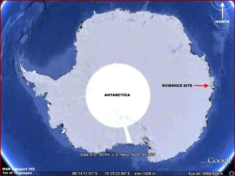
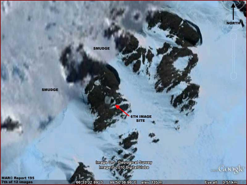
For any who wish to track behind me, the above 1st image is included here to help locate the evidence site on the coastal area of Antarctica at the Southern Sea but inland from the coast. When zooming in on this site in Google Earth, one will encounter a narrow pale blue strip at this location within which the evidence reported on here resides. That pale blue strip is a corridor of high resolution surrounded by an extensive sea of smudge obfuscation and that narrow higher resolution strip is the sole reason why we are able to view just a little truth here.
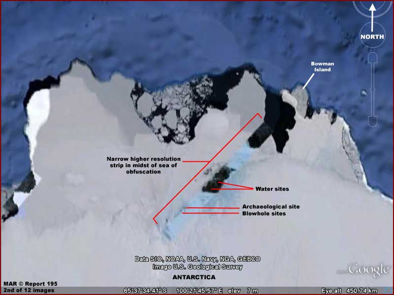
The above 2nd image is another context locator image but this time closer and showing what the pale blue narrow strip of higher resolution looks like and the location of the main evidence sites within it. If the whole of the Antarctica continent was revealed at this kind of higher resolution, there is no telling what many kinds of truths would be revealed to us in the public. Further, one can't help but get angry when one realizes that we in the public treated as a bunch of dummies are otherwise disrespectfully fed a load of unmentionable material even though we paid for the real thing but certainly aren't getting that in return.
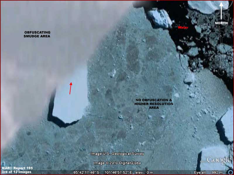
The above 3rd image is an example
of what I mean. The white blank smooth area in the upper left corner of the
image is smudge image tampering obfuscation as viewed relative to and side-by-side
with a relatively much clearer not obfuscated right portion of the image.
Note the sharp straight boundary between the two fields. Note how a portion
of the big rough chunk of broken ice casting a dark shadow and with the red
arrow on it disappears up under this smudge coating and how nothing more of
it, not even a suggestion of it, can be seen through the smudge demonstrating
just how thick and obscuring the smudge really is.
Note also that because the Antarctica continent is in theory mostly covered
by snow and ice and snow and that solid particulate is so bright sunlight
reflective, we likely wouldn't know the difference if we were looking around
in the smudge areas and encountered only some occasional poorly seen blurry
rocks. We would likely just pass the poor visibility and lack of any detail
off as due to the bright white sunlight reflectivity, fog, etc. However, the
above A-B comparison and ruler straight boundary reveals the real truth as
to the presence of the obfuscation and this comes to us only because someone
by mistake or intent (rebels within?) allowed this narrow satellite strip
of truth to be included and come through to us.
By the way, that light green/bluish tint surface that may look like land to
you in the above 3rd image is actually very old thick ice floating on water
with the edge of the dark water just visible in the upper right corner of
the image. I suspect that the ice is tinted this color because it is almost
certainly fresh water with microbial life in and on the ice causing the tint.
Be glad of it because it is also causing the ice to be less sunlight reflective
compared to the big elevated iceberg chunks also present. This slight darker
sunlight absorbing rather than sunlight reflecting quality contributes to
our being able to see better detail rather than it being washed out in white
color.
In any case, as we move up this narrow corridor of higher more true imaging
resolution, let's examine a few mysteries along the way in the evidence as
follows.
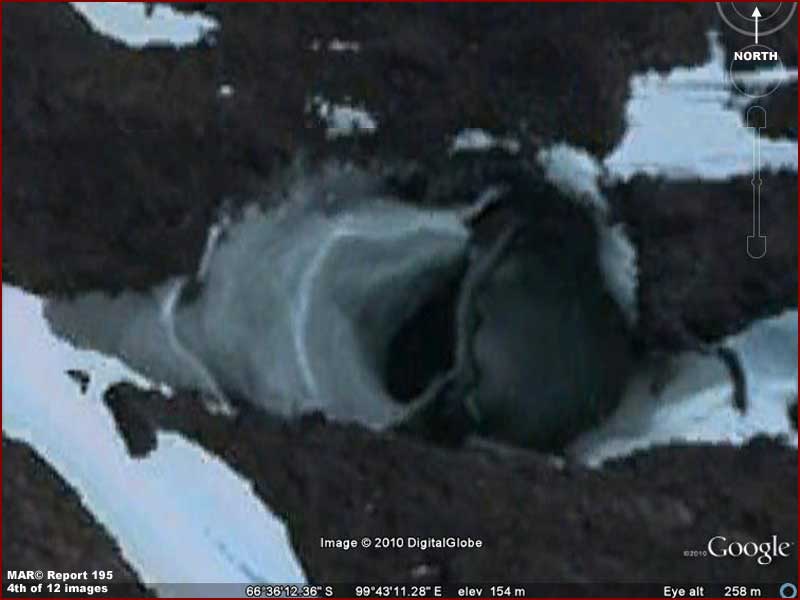
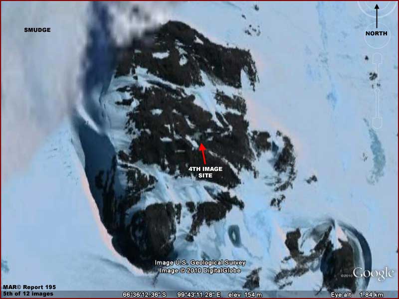
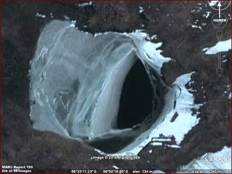
The above 4–5th and 6–7th
image sets are of the same type of evidence in two separate locations not
very far from each other in this narrow corridor of Google-Antarctica imaging
truth. For the lack of a better term I've called these two sites "blowholes"
and their general location is in the labeling in the 2nd image in this report.
However, blowhole is misleading as you will see below.
This evidence at first resembles blowholes such as that caused by volcanism
created heat deep down below that in turn causes heated water to rise and
exit as a vent on the surface and so it is natural to interpret these two
sites as that. However, take a closer look at these two holes in the 4th and
6th images.
Note that the ice in the hole downward slope is mostly and oddly confined
to the left site of the hole in both sites. Also note that this ice on the
left side has a slight greenish tint to it as compared to the rest of the
snow/ice in the hole's general vicinity. This indicates that the source of
this ice on the left is from within the hole as compared to the other vicinity
ice which is much more likely surface snow/ice in origin.
If this was a natural water vent, we should expect that the water with the
slight green tint exiting the hole would be much more generally distributed
and spread around the hole and its outer surface areas. The fact that the
slight green tint ice is confined to the left side only in two separate sites
is a bit anomalous and suspicious. Also, note that both holes are elliptical
in shape and oriented in the same direction which is again a bit anomalous.
Now it could be that the left side of each site represents a depression relative
to the higher rest of the sides of the holes. If so, it could be that heated
water welling up from below but not really fully venting may on occasion rise
and push into the depressions and then drain back in the hole leaving water
behind on the left side to shortly freeze into the slightly green tinted ice.
Unfortunately, this straight down satellite view doesn't allow us to determine
if this possibility may be so.
On the other hand, both sites separate some distance from each other have
a little too many similarities that strains the chance factor considerably.
It is also possible that they are permanent but camouflaged exit points in
rocky terrain for some solid wide but flattened objects exiting from underground
to the surface environs always in the same direction and via passage first
through the water and then up in the air carrying water shedding off the object
always dropping off in the same place on the hole left side.
It would have helped considerably if this higher resolution strip would have
encompassed a larger general area of this terrain as opposed to this narrow
corridor. Perhaps there is more of this type of evidence to see that could
be more informative as context information? Unfortunately, the view here is
just too narrow a slice to be drawing much in the way of definitive conclusions.
At this point there's just enough truth for it to be really anomalous and
suspicious. The key to the above Antarctica evidence is inland fresh water
presence in a liquid unfrozen state and the next evidence below will be of
this as well.
Before getting into that, did you know that statistically this continent contains
70% of Earth's fresh water? Of course most of that is suppose to be in the
form of snow/ice solid particulates laying around sometimes thousands of feet
deep on as well as offshore of the continent. You should know that the average
temperature in the Antarctic is –49º C with the coldest temperature
on record and the coldest on Earth being –128.6º F or –89º
C. In other words, its very cold and most of the time far below the freezing
point of fresh water.
However, in the peak of summer the temperature can rise to a whopping 41º
F (5º C) to 59º F (15º C) for a very short time. Note that
these temperatures are above the freezing temperature of water at sea level
but remember that such "warm" temperatures can last for only a few
weeks with little impact on large bodies of ice.
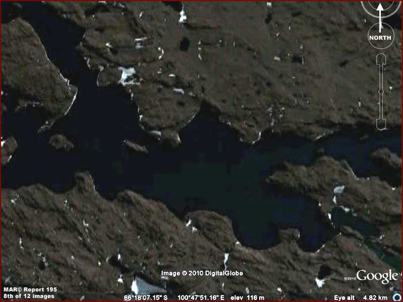
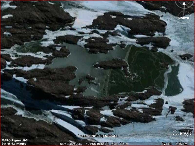
With that said, the above 8th
image demonstrates a considerable size inland body of green tinted water in
a liquid state embedded in elevated rocky terrain. Note that there
is no floating ice and only very small residual patches of snow/ice in terrain
depressions around the site. That is very significant. Further, this is just
a single sample and there is many times more of this same unfrozen liquid
water evidence north of this point in this rocky terrain not shown here. There
is so much in fact that incredibly it all represents an extensive network
of mostly interconnected and mostly navigable large water ways.
Considering that this incredibly is located in the supposedly coldest freezing
conditions on Earth where ice extreme thickness lasts for thousands of years
without melting, this large area of fresh water presence in a liquid state
is extremely anomalous. Also, since there is hardly any ice presence even
right at the lake shorelines, we can assume the fact that it is not frozen
over likely means that this is deep water right up to the shorelines and perhaps
even lightly geothermally heated from below over a large area.
Note that the rocky terrain is also mostly free of snow/ice. This too is typical
of the overall site as viewed in Google Earth. Obviously, the temperatures
in this general area may be cold from our point of view but the visual evidence
here clearly demonstrates that it is just not cold enough to support extensive
snow/ice presence no matter what is "suppose" to be the case in
Antarctica.
With that thought in mind, I've tried to look closely time permitting to see
if I could see any signs of civilization evidence in this liquid fresh water
mile temperature lost world but I see none that stand out enough to really
identify as such. If any is there on a size scale large enough to see at this
strips resolution, it has been carefully erased to blend in with the rocky
terrain which is itself too uniform in coloring causing me to suspect tampering.
If that suspicion is true, then someone has allowed us to see the liquid fresh
water sites but anything more than that is apparently taboo.
On the other hand, the above
9th image evidence is located over on the right edge area of the rocky terrain
going out into snow/ice fields. It demonstrates what clearly appears to be
green tinted surface water shallows also in a liquid state. Note that the
left side of the water site is shallow liquid water while the right side seems
to be a darker tinted green and likely biological growth of some kind on wetlands
associated with the water site with the growth doing its conversion of sunlight
to chlorophyll thing.
Note that, although plenty of snow/ice is present all around the site, the
water is still in at least a partial liquid self leveling state. I've included
a view of this evidence because the water is unmistakable even in outer terrain
areas like this and this site also seems to present the added bonus of living
bio-life evidence as well on dryer ground.
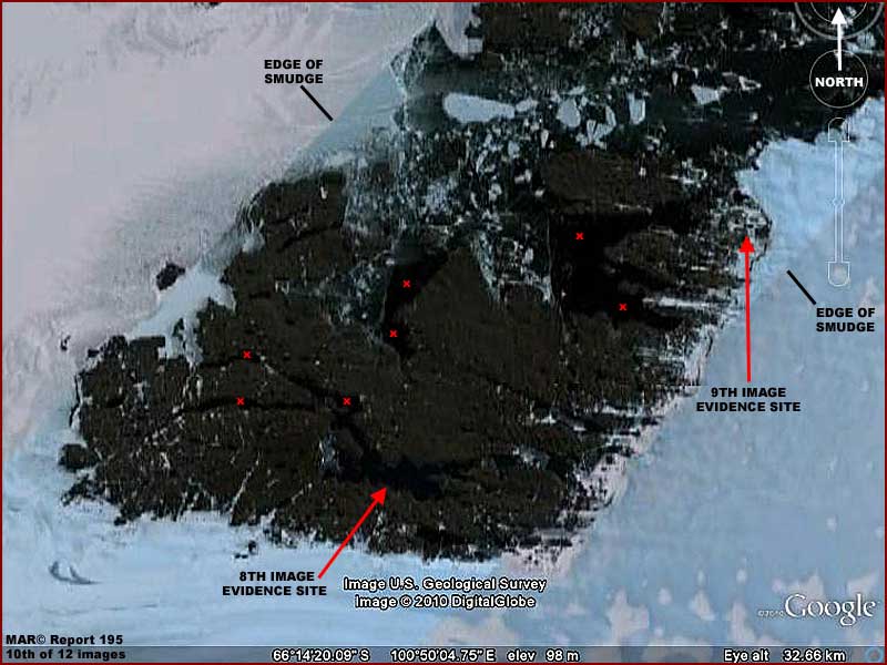
The above 10th image serves
as the context locator image for the 8th and 9th image's liquid surface water
site evidence pointed out with the red arrows. The many small red "X's"
in the image represents a sampling of the other largest water sites. In addition,
there are many lakes and entirely landlocked
smaller bodies of liquid water that are present in this area. I have not bothered
to point out or document here in this reporting because it would take just
too many images.
Above the large water body sites you will see a lot of jumbled ice presence
and these for the most part represent water sites where the water depth is
more shallow allowing more ice to form. At the same time there is a great
deal of large broken up sections of old floating ice presence in the upper
area that suggest this area has in the past been more covered with ice. It
may be that the external weather temperature has not warmed so much as the
land itself geothermally from below (?) resulting in melt and floating ice
breaking up.
Please note in this 10th context image how closely the rocky terrain visible
out of the snow/ice with this liquid water evidence is so closely boundaried
by the ever present smudge obfuscation fields on either side. It almost seems
that someone intentionally fitted this corridor of higher resolution satellite
imaging just so that this fabulous huge and extensive unfrozen navigable liquid
water site geology could be found by someone in the otherwise heavy obfuscation
of Antarctica. Who do we thank, aliens or rebels?
With not only ice free deep fresh water lakes as well as deep water navigable
winding waterways and large open bodies of fresh water in networks and a mostly
snow/ice free rocky terrain extensive landscape clearly demonstrating ice
free milder temperatures, one has to ask why are humans in the Antarctic freezing
in other much more difficult to contend with locations. This seems like a
much more practical location for a permanent settlement supplied by air with
a real landing strip.
Could it be that there is something recognizable out there secret and hidden
from our sight under those boundary smudge obfuscation fields that would preclude
the consideration of such a human settlement presence? Could it also be that
there is evidence at this site that even I cannot recognize as that anomalous
because it is just too unfamiliar to even my eye? Indeed, it you choose to
close inspect this area in Google Earth to confirm my findings here, there
is much here in this rocky outcrop area that is very strange looking and therefore
speculative and especially in the upper environs.
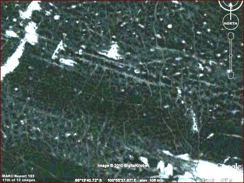
The above 11th image is a sample
of some of this strange looking evidence looking very much like a lot that
I've seen on Mars. In this image it is a dense tangled web of crisscrossing
ribbons that appear to exist on formerly wet fresh water site bottoms that
are now exposed to the air.
Note how some of the longer ribbons above are not straight but tend to wander
around while still going in a specific purposeful direction. In the upper
environs this is typical as are the presence of densely packed knobs by the
thousands just out of definition reach of the image base resolution. Also,
in other nearby locations these wandering type continuous ribbons seem to
connect and/or bridge between multiple very white fresh water ice masses scattered
at random throughout the terrain as though they were paths created by something
purposefully accessing the fresher whiter ice not suffused with the green
tint. In other cases, the irregular but continuous ribbons also seem to serve
as dams blocking floating ice and forming enclosures with floating ice sections
in them. Someone managing ice chunks?
The question becomes does this represent some form of life that we are unfamiliar
with and find hard to recognize? Perhaps life that does not lay out its systems
in very rigid geometric shape as do we Earth humans? The resolution is great
enough in this strip to raise more questions but it is not good enough to
answer other questions.
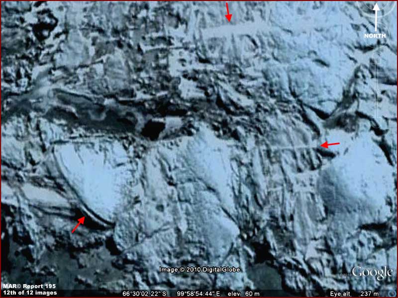
The above 12th image is in my
opinion an evidence debris field site located just north above the 4th—7th
image evidence sites and well below the many fresh water sites area. Now let's
understand that this evidence is very suggestive rather than in any way definitive.
The red arrows point to some of the more suggestive evidence.
This does appear to be a chaotic debris field consisting of partially buried
and exposed objects, some of which should be of major interest. At least I
think they should be of interest to any archaeologist with even a small amount
of curiosity but who can think some outside the box as to the possibilities.
I know that I would love to be part of any expedition to this place that believes
in truth. Is that giant rounded object in the lower left the remains of the
leading edge of a partially burled disk type craft or some other tremendous
rounded structure that met its fate in some ancient cataclysm?
I must say that suggestive level evidence abounds in this report of this general
site that encourages speculation as to both current and ancient alien presence
that the image strip alone cannot adequately answer. On the other hand, who
would have ever expected to find in Antarctica the coldest place on Earth
a very large site literally littered with deep fresh water in a liquid state?
Is it a lost world or just someone else's world?
Either way, if I am the first to publicly discover and report on this incredible
unfrozen liquid fresh water evidence (?) in Antarctica, I think I'd like to
call it something I've never done before. However,
my irrelevant personal desires aside, make no mistake about it, here's the
bottom line with this hard visual evidence from Google Earth.
The at least now public discovery of this undeniable area of surface water
in a liquid state and the lack of significant
snow/ice presence in this rocky terrain area of Antarctica, supposedly the
coldest place on Earth, will have official types and debunkers scrambling
and back pedaling for explanations. As damage control they will be trying
to convince us that this is just the result of a "natural" underlying
geothermal hot spot in the land that is causing these obvious very isolated
warmer conditions and that such sites are extremely rare. Such an explanation
will to the innocent likely sound fairly reasonable and many will accept it
mostly because they want to.
However, let's think about this a little deeper. In all the many past decades
of various settlements established by many nations around on this continent
and its many coastal ice masses, why has this obvious warmer conditions site
not already been settled? After all, these warmer conditions and fresh water
and the location on land just inland from the coast make it ideal. Who would
want to explore a frozen continent from the bases that we do have established
where one is freezing one's buns off and it is life threatening deadly to
go outside without extreme cold weather gear on? Does this make any sense
to you?
Likewise, look again at image #3 near the top of this report. See that obfuscating
smudge blotting out every thing in the land beneath its applications in the
upper left corner and side of the image. I would guess that the bulk of the
Antarctica continent is hidden from view in this way in varying degrees. WHY?
Surely this question must occur to you. What is it that someone doesn't want
us to see in Antarctica? Why is it necessary to obscure most of an entire
continent in the satellite imaging rather than just some isolated places?
Remember, this is a large continent and not just an island at the lower end
of this world.
I remind you once again that shortly after WWII an "expeditionary"
military force (an entire fleet including an aircraft carrier) of ships and
thousands of men were sent to Antarctica for "exploration" purposes.
Of course such a large military force commitment suggests a covert secret
mission cranking up the rumor and denial mills. Further, although this is
officially denied, it has been rumored that two atomic blasts were set off
some where at or near Antarctica back in those post WWII times. In fact, although
I didn't understand the significance of this at the time some years ago and
didn't preserve it, I've seen pictures that included a fleet of ships in the
foreground, a completely snow and ice covered landmass and mountain range
in the far background, and an unmistakable atomic blast between the ships
and the landmass. The presence of a high mountain range suggested Antarctica.
I don't know about you but to me that's a lot of USA military activity in
force after WWII was over. It's also a huge expenditure of money, materials,
and man power post WWII (with USA citizens in lean times economically recovering
from the war effort) to allegedly test military post war cold weather military
operations in case of future war with the old USSR and/or investigate the
frozen desolate home of a bunch of cold hardy seals and penguins or even a
few isolated diehard freezing Nazis.
Could it be that those few freezing Nazis, if they existed at all, were interacting
with someone else long established there and that this someone else was the
true target of the USA military operation and that the Nazi presence was just
a covering misdirection rumor in case it was needed? If so, the continued
obfuscation of Antarctica in the satellite imaging into the present tells
us that control of the continent was likely NOT established by this military
operation. Further, if the story of atomics being used is true, it suggests
that who ever is there is able to withstand the use of atomics, were not impressed,
and perhaps we've had to accept some compromises with respect to who controls
the bulk of this land?
On the other hand, is someone who is us here on Earth trying to hide the habitable
conditions in Antarctica to give themselves the time to establish a firm military
control presence there? In light of the fact that other nations could monitor
such activity via their own satellite over flight imaging, this does not seem
very likely.
That's a lot of speculation but then there is the fact of all the obfuscation
applications covering most of an entire continent as sampled in image #3 here
and that undeniable liquid surface water presence in images #8 and #9 clearly
demonstrating warmer conditions. That kind of hard verifiable imaging evidence
is hard to get around and explain away. Could it be that someone else not
us right here on Earth is calling the shots in this land confining
our settlements to its periphery?
Now all that visual obfuscation is there for a reason
and so I suspect this report may hit a soar spot among the secrecy types.
So I suggest that all of you around the world who can please go quickly to
this spot in Google Earth (following my visual directions) to download, document,
and preserve this evidence before it can be sanitized following this reporting.
Addendum Added 12/12/2010:
It appears that the site of this evidence and its year round unfrozen fresh
water in a liquid state is named Bunger Hills and was first discovered and
filmed by a seaplane flight in 1947 commanded by Navy Lieutenant David E.
Bunger surveying and filming as part of the infamous military 1946/1947 Navy
expedition in force named US Navy Operation Highjump overall commanded by
Rear Admiral Richard E. Byrd, Jr. It seems the plane landed on the water confirming
temperatures of 38º and that it was fresh water. Note that I've included
duplicating material video links below containing 1940s film of this discovery
just in case some links are lost in the future. The site is located about
about 220 miles or 350 km from the Russian Mirny Station to the west that
is part of my Report
196.
http://www.youtube.com:80/watch?v=0x40A0sBL34&feature=related
http://www.youtube.com/watch?v=D7UG1aPqwqE
http://www.youtube.com/watch?v=cGtvXOvqYZg&feature=related
I've checked the coordinates and the Bunger Hills
location is the same as that in my report. Of the great many lakes in this
area, the largest and longest is Algae Lake (aka Lake Figurnoye) some 16 miles
or 25 km long and up to 449 feet or 137 meters deep. Admiral Byrd described
the area as ".....one of the most remarkable regions on Earth. An island
suitable for life had been found in a universe of death." Also, apparently
the Russians attempted to establish a small station on this site in 1956 named
Oazis later turned over to Poland in 1959 and renamed Dobrowolski Station
none of which amounted to much and eventually was abandoned.
This information is important as context but it really doesn't have that much
to do with my reporting and observations except to confirm formal discovery
and awareness of this site by others prior to my reporting. I'm not going
to bother with it but if someone were to go to the trouble of making a very
careful survey of the entire site in this reasonably good imaging and no evidence
of the Oazis/Dobrowolski Station sites were revealed, I would suspect the
presence of careful image tampering inadvertently covering this visual information.
, Investigator
![]()