
GOOGLE EARTH & TRUST
Report #161
April 12, 2009
In my email feedback, I get questions
about whether or not Google Earth's content can be trusted. Of course most
such questioners want a simple straight forward answer but it isn't as simple
as that. Why? Because the answer depends on many factors coming from many
different angles. For example, what use do you wish to put Google Earth to?
It will serve some purposes well and others it will not be a reliable tool.
Do you want to track elephant herds in Africa? Do you wish to gain a global
perspective for vegetation growth versus arid wastes? Do you wish to review
how cities are laid out around the world for future improved metro planning?
Do you wish to track population densities around the world and their visual
impact on ecological systems? Are you interested in researching global geology
and its changes? As long as your research will not be inconvenient by revealing
questionable activities of governments, militaries, or mega corporations that
they wish to keep secret, the productive possibilities are there. In such
endeavors, Google Earth is a good tool because you may get some reasonably
truthful results with it.
On the other hand, are you interested in researching whether or not your government
or some giant influential corporation in conjunction with them is illegally
polluting your land and/or someone else's off in lonely out of the way places
away from watchful public eyes? Are you interested in researching military
sites and activities? Use your imagination and the list of unacceptable use
from the secrecy point of view goes on. In other words, do you expect Google
Earth to be a tool in revealing information influential others wish to keep
secret? If so, that's a horse of a different color as the saying goes.
Now don't get me wrong, explorations in Google Earth and other such programs
can be revealing but only to an extent and expectations have to be geared
to reality. Let's face it, there is some information out there that needs
to be secret from prying eyes. For example, from one country and military
interest to the next and nations and militaries would be incredibly stupid
not to do so. After all, tactical intelligence is power. When trying to explore
this kind of information, the reality is that one can expect it to be obfuscated
as much as possible. Never forget that this is true in a commercial program
like Google Earth as well as at ground level trying to inhibit insight from
satellite views from above that do not suffer Google Earth limitations.
Obfuscation technology is an advancing science. However, it is not perfect
because those humans who developed it are of course not perfect. People make
mistakes and/or fail to anticipate all that they should and sometimes monetary
limitation also play a role. This all can show up in the technology of the
Google Earth imaging. It is via such mistakes that knowledge is gained for
people like you and I that wish to uncover what others would keep secret.
That is if one is willing to correlate a lot of bits and pieces of information
and extrapolate logically from them without prejudice or prejudgment.
For example, what is going on at the South Pole aka Antarctica? There is nothing
down there but snow and ice and some Penguins. So there is surely nothing
to hide, ........right?
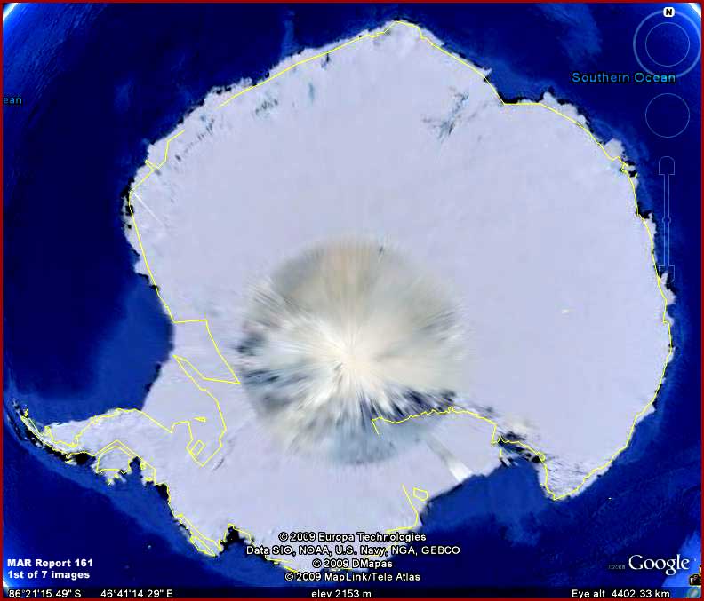
The above first image is a view of
the Earth's South Pole or Antarctica. Did you know that there are some significant
and important differences between the North and South Poles? For example,
the North Pole or the Arctic is a frozen ocean of ice surrounded by land masses
while the South Pole or Antarctica is an entire continent with mountain ranges,
rivers and lakes surrounded by oceans. Did you know that Antarctica has 90%
of the world's ice and 75% of the world's fresh water?
Did you know that as early as 1939 a German military expedition visited Dronning
(Queen) Maud Land in Antarctica allegedly with the intent to establish a Nazi
military base there. Did you know that between 1943-1945 British SAS troops
allegedly launched a secret wartime operation code-named Tabarin there to
root out the German base. Did you know that in 1946-1947 right at the end
of WWII the U.S. in secret sent an invading fleet task force there code-named
Highjump and that in 1958 there were three nuclear explosions set off in this
general area code-named Argus. Note that all of these were highly classified
operations. Did you know that all kinds of speculation on UFO and alien bases
and contact is associated with these Antarctica events and locales.
When material relating to this was declassified long years later, explanations
were revealed that essentially denied any German or alien presence there and
any need to deal with it. For example, the U.S. explanation was that the task
force was a exercise training troops for preparedness for a potential fight
with Russia in extreme cold conditions. Now that's in 1946-1947 immediately
after WWII! Can you accept that? I would question the reasonableness of such
explanations. Likewise they also say that the nukes were detonated 2000 km
north of Antarctica in the ocean. So who's to know the difference?
With that background and its implications in mind, note the above 2009 Google
Earth satellite image of Antarctica. Obviously the center area is thoroughly
obfuscated on a continental scale and you're going to find nothing to see
there. Likewise, the bulk of the rest of the continent is much obfuscated,
so don't count of being able to see very much there either. It's the same
with the coastlines and underwater. I might add that it was the same with
the previous years version of this view and so the 2009 view represents no
improvement over previous satellite imaging.
Please do not bother with explanations that the center area obfuscation is
due to polar aurora or electro magnetic fields. If it was, it wouldn't have
this round uniformity. Further, the whole point of satellite imaging for Google
Earth uses is to image the terrain in a given area. Even if an aurora was
some how visually obscuring the terrain below it, this view would be rejected
in favor of subsequent satellite passes when auroras are not obscuring the
terrain. If this were not the case, then whole huge sections of the Earth
in the satellite imaging would frequently be completely obscured by cloud
fronts in various areas instead of a few clouds here and there. In other words,
satellite Earth imaging is a selective process chosen for clarity and not
a one time one shot situation.
The obfuscation is pretty obvious. Someone clearly doesn't want you and I
to see much of anything here and is willing to
be fairly obvious about it from a detection point of view. While you're contemplating
this, remember that other countries with their own satellite imaging capabilities
or the money to purchase it from other private sources are not affected by
this obfuscation, only you and I in the public and many scientists around
the world that may use consumer commercial programs like Google Earth. Anticipate
that it will be the same with the newer programs like Google Earth: Ocean,
Google Mars, and the Microsoft Worldwide Telescope.
So what the hell is so secret about the Antarctic continent as seen from space?
I don't know the answer to that but it appears clear that there is something
to hide here and someone is not taking any chances that we will be able to
see even a suggestion of it. I suspect any such answer is likely going to
go back to World War II and possibly before whether it has anything to do
with secret German or UFO bases or not.
One thing we can figure out, it is very cold down there. Brrrr! Now let's
move on to where its warmer, namely the tropics and the island of Puerto Rico
in the Caribbean Sea south of the USA. There the obfuscation evidence is a
little more subtle in its application but still just visually blanketing large
tracts of terrain.
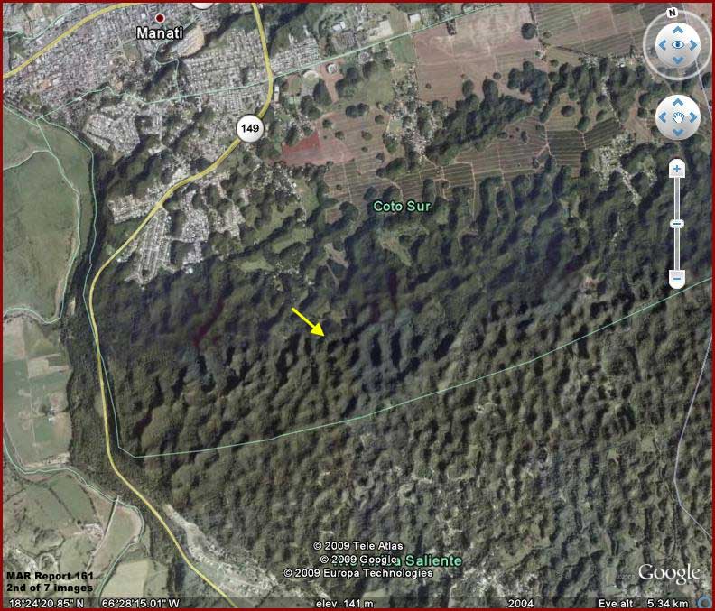
The above series of second, third
and fourth images are fairly self explanatory. We're looking a large tract
of heavily forested ridges located south of the city of Manati
in the interior located in the north central portion of the island of Puerto
Rico. The yellow arrows point out the anomalous evidence and it is quite obvious.
This was brought to my attention by a sharp eyed viewer from the desert wastes
east of Phoenix who probably should remain anonymous since this discovery
might just step on some secrecy toes.
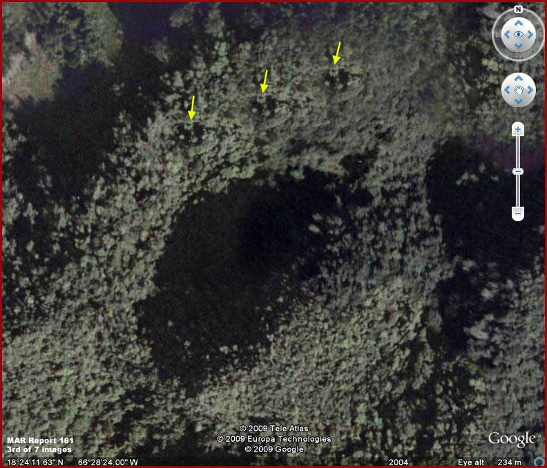
As you can see, this forest scene looks very real doesn't it. However, the
anomalous evidence consists of three identically repeated places in the thick
forest on one of the many ridges down there. What this tells us is that this
forest visual has been artificially applied in this spot and is very clearly
false. The method is likely via a graphics program clone stamp where a real
scene is extracted from another location and in this case repeatedly "stamped"
incompetently three times repeatedly side-by-side in this one spot. This means
that we cannot no longer have any confidence that anything we are looking
at down there in this forested area is real.
In other words, something is down there that someone has gone to considerable
trouble to hide and disguise with illusionary obfuscation treatments masking
what ever ground reality is there. Note how much more subtle and less obvious
this type of image tampering is relative to that in Antarctica. This is designed
to sooth the viewer's brain and create the psychology in one's head that everything
down there is okay, it's just trees, of no interest, and we can just move
on.
Once the implications are realized, the next question then becomes how extensive
is this type of subterfuge? Does it affect only this ridge location as a limited
area or a wider area? Is there any kind of further investigation we can do?
As it turns out there is.
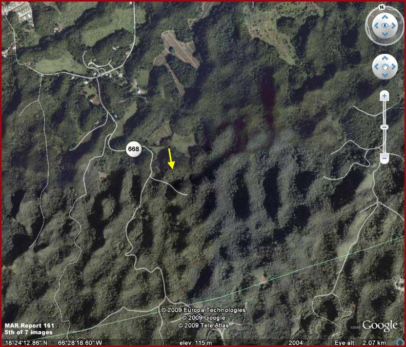
In the above fifth image, the yellow
arrow once again identifies the same anomalous evidence site found to be using
the clone stamp replication. However, here I've turned on Google Earth's roads
representation function. The white lines you see are graphical representations
of those roads and not the physical roads themselves.
Please note that one west to east dead end road just below the yellow arrow
crosses right over the same ridge and down into the little valley bottom close
adjacent to the repetition tampering evidence and up the opposite side. Now
go back up to this report's 3rd image that shows the entire ridge and valley
evidence area. Note in it that this west to east road is not present at ground
level nor is there even the slightest trace of it among the trees.
Additionally, note that this short dead end road junctions at its beginning
to the west into a road that has the number 668
on it. That number tells us that 668 is a larger more important in use road
passing north/south through this area of heavily forested ridges and valleys.
Note that there are also other roads in the general area. However, when one
closely examines where those roads are physically suppose to be in this satellite
imaging, most of them are simply not there over this wide area.
Now in my experience Google Earth visually mapped depiction of roads is accurate
in the terrain. Other roads on Puerto Rico in similar forested terrain are
well and accurately represented and confirmed to be there either as being
obvious or at least via faint traces. So we can safely assume that the roads
are actually there in the real world.
However, as I say, the physical roads are not there visually in this Google
Earth program and this problem is extensive over a wide but limited area of
these ridges. This suggests that the clone stamp technique revealed on the
ridge pointed out by the yellow arrows has actually been at work extensively
all over a much wider area. However, although it is without any forest clone
stamp repetition mistakes, its application was again careless because it has
covered over many of the roads hiding them from view with its fake stamped
scenes revealing that the terrain we are seeing is almost certainly not real.
Now forest growth is always encroaching on roads and especially in lush tropical
settings. So one might observe that the forest canopy could be hiding the
roads from our view. This is normal and I've seen plenty of it in satellite
views. However, even when tropical forests are strongly encroaching on minor
dirt roads, one can still see road sign from strong to faint of the roads
among the tree growth and I've seen plenty of this too. In fact it is this
way in other forested locations on Puerto Rico.
However, what we often have in the above terrain scene is a complete absence
of any signs of roads where Google Earth says they are suppose to be nor can
any roads be observed out of position nearby. This strains reason considerably.
For example, road number 668 is likely a fairly major well traveled and maintained
north/south road and yet it too is visually gone in most places down its length.
In comparison, other roads in other areas of these heavily forested ridges
both obvious and faint can be well seen demonstrating how they can be recognized
in this environment, so forest canopy encroachment over roads is not the problem
here.
Obviously, just as with Antarctica, someone has gone to a lot of trouble to
make sure those in the population like you and I do not see what ever is in
this area. The difference is that the tampering applications are more subtle
here creating illusions communicating that everything is okay and no need
to pause and look closer. Just be content and move on is the desired visual
message. The bottom line is that I have no idea what might be here in this
locale on this U.S. territorial possession but what ever it is, it is obviously
a big secret and worth the effort to hide it in this way.
I thought to myself, okay what about Arecibo? You know, the largest radio
telescope dish in the world focused into deep outer space and once the site
of SETI or the Search for Extraterrestrial Intelligence before funding for
it was cut. It is not too far west of the above evidence location and also
in these same type of dense forest covered ridges. There was an attempt to
close Arecibo in the recent past but it has been kept open. This may be because
it is known that the Arecibo location is also a source facility of VLF (very
low frequency) EM (electromagnetism) transmissions. That would of course make
it a facility worthy of secrecy.
So I investigated the Arecibo site in Google Earth. The dish site is well
displayed and seen nestled down in a small valley hole or sink surronded by
ridges simillar to the one imaged here. However, sure enough, while major
roads around it are displayed and seen, nearby lesser roads around Arecibo
are graphically displayed but visually gone in the terrain. Now understand
that all this discovery is in comparison with other locations around Puerto
Rico in these densely forested ridges in the interior. In these other cases,
major and minor roads are both accurately displayed and can be seen normally.
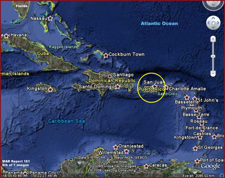
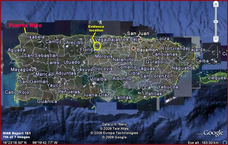
The above two sixth and seventh locator
images are included here to help any of you around the world who wish to investigate
this evidence behind me within Google Earth and will facilitate zeroing in
on it. Remember that when you're zooming in of the Puerto Rico island at the
location demonstrated with the yellow labeling in the above 7th image, you'll
be wanting to zero in on the city of Manati and
the area just south of it. Note the above 2nd image for this location purpose.
So back to the question and issue of Google Earth and trust. As you can see,
it depends on what you wish to achieve within the Google Earth program. If
you are expecting Google Earth to be truthful at all times, that just isn't
going to happen. However, technical mistakes can be made as you see here revealing
something and also someone may leave evidence exposed if they believe that
you and I can't figure it out for what it truly is. Otherwise, if you're making
expectations out of Google Earth to be a useful tool on things that governments,
militaries, and mega corporations don't find potentially threatening or inconvenient,
Google Earth can be a productive tool for that.
There is also another Google Earth trust issue. Note the designation on the
above Google Earth images suggesting that they are from 2009 data. As most
users would interpret it, that of course implies updated 2009 imaging. However,
don't buy into that. As a control, I investigated my own territory where I
live that is also currently designated 2009 data. Lakes in my locale that
are well known to me and have been dry now for several years are full of water
in the 2009 Google Earth data indicating much older data. A nearby home that
has been built and occupied for several years now is not even present in Google
Earth again indicating much older data.
What you have to understand is that Google became a mega very high tech business
empire very quickly from a start-up. That means making many compromises along
the way to get so big so fast. Think about it. If you were part of the secrecy
crowd charged with making decisions and with super deep financial pockets
with your fingers in everything of importance, would you allow such a high
tech company to grow unchecked with no controls on it and without your agenda's
presence within it? When it comes to who Google may be willing to offend and
who it can't and who it must comply with, consider the following not so subtle
clues.
Google's main research/lab facilities are located in 1-million square foot
facility provided at NASA Ames Research Center. Its main satellite connection
is GeoEye which is the world's largest space imaging corporation. GeoEye is
a major client of the super secret National Geospatial-Intelligence Agency
(NGA) which specializes just for starters in military space and satellite
technology and intelligence. The NGA in turn is a part of the U.S. Department
of Defense (DoD) and a member of the U.S. Intelligence Community. In other
words, the FBI would call those associations real clues.
It doesn't stop there though. For example NASA Ames technology, in addition
to the Google Earth product, is enabling Google Mars, Google Earth: Ocean,
and Microsoft's Worldwide Telescope. However, all of these, in my opinion,
employ technologies that create graphical textures.
These creations are suppose to be representative of the real thing but, make
no mistake about it, they are not the real thing. As this work as shown, many
times even what is suppose to be the real thing science data too often isn't
that either.
In my opinion, while this cooperation with Google and Microsoft so called
private enterprises is touted as making satellite exploration data more accessible
to the public and thereby a great thing for public tax dollars and easy to
sell in that way, it is at the same time introducing private enterprise intermediaries
not necessarily responsible directly to the public into the mix positioned
between NASA and JPL and the public to take any initial heat should things
start going south in the public's perception. Since the public expects less
out of private enterprise than it does out of those it funds and charges with
pure science and exploration, this has an obvious potential down side for
the public because it tends to relax public pressure and controls trying to
insure clean and real science data.
In any case, as you can see in just this brief examination of this subject
matter, the issue of Google Earth and public trust in its content is full
of compromises and complexities. Often complexities that appear to be one
thing but have the potential to be something entirely different.
, Investigator
www.marsanomalyresearch.com©
![]()