
NEVADA COVERT AIRFIELDS
Report #155
January 8, 2009
Twelve images & slow loading time
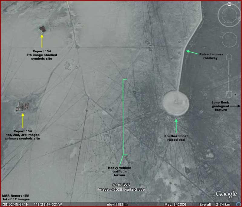
The above first report image is
a context image of sorts. On the left pointed out with the yellow arrows are
the two primary placement symbols sites appearing in my previous . On the the right is the southernmost of three raised round
pads and access roadway pointed out by the green arrows. All are located out
in the middle of no where in the state of Nevada wastes of an old essentially
dry lake bed now in a desert setting as described in the previous reporting.
In the above image note the pad's location relative to the site on the left
with the strange symbols. Both are certainly in the middle of no where far
removed from prying eyes but they are still relatively near each other and
on the same horizontal plane. Now note the very high amount of vehicle traffic
patterns imprinted in the terrain just to the left or west of the round pad.
Now this traffic could have been done at a time previous to this pad's construction
but more than likely this is evidence that this particular pad site has been
used a lot in more recent times.
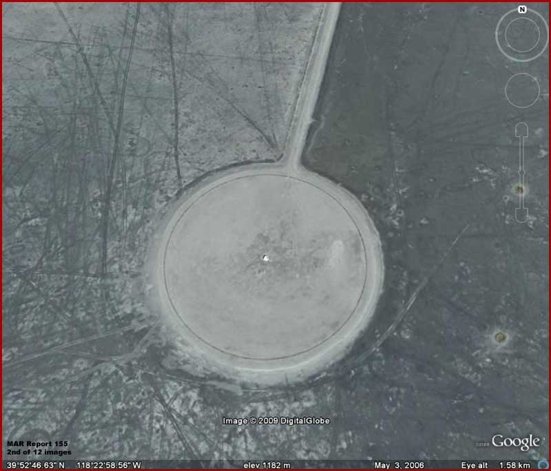
The above second image is a closer view of the round pad in the first image. What I want you to note here is that this is a raised heavily compacted round platform. Note that the access roadbed is the same raised and compacted construction. This is typical of all of the evidence presented in this reporting. Note also that the access road terminates into this southernmost site.
Now the
above third image evidence is a short distance north via the raised access
road on the left from the previous site. Note that this mid-area site has
been constructed over an old bombing range site as evidence by the many small
to larger conventional bomb craters that dot this area. This bombing evidence
clearly predates the raised construction as evidenced by the fact that the
construction is laid down over the bombing scars.
This type of site differs from the previous one in that it demonstrates not
only the raised round pad now with concentric dark ring lines on it but also
a strait east/west roadway dissecting the round area the equivalent in construction
of the north/south access roadway. You'll also note that the terminating ends
of this dissecting roadway expand out slightly into rounded configurations
that I've labeled as "turn around's." Finally please note the short
north/south raised short extensions sticking off of the round platform.
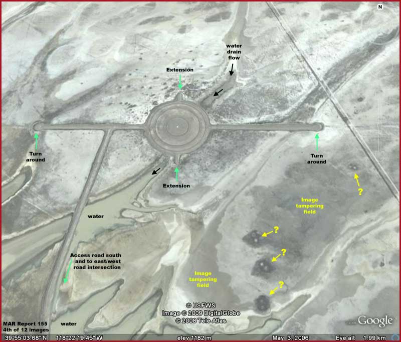
The above fourth image demonstrates
the northernmost of these three sites. As you can see, it is designed and
constructed the same as the previous mid-area site in the old bombing field.
Please also note that the raised access road terminates at the northern site
location similar to the way it does at the southern site.
Despite the obvious shared design and construction features, the above northern
platform site differs from the other two sites in important ways. Note that
this site has little sign of vehicle traffic in the terrain off of the raised
areas. Note that there are also signs of shallow water presence around it.
In fact it appears that snow melt water periodically drains down from the
highlands north and east of this site and one of the drains appears to pass
right under the round platform here without eroding it or deflecting around
it.
This brings up the question of the toughness of this raised bed construction.
Are they just made of soft fill from the surrounding terrain? The answer would
be yes and no, but mostly no. While the area immediately beside the roadway
does show signs of excavation to help form up base areas, no portion of either
the raised platforms or roadway surfaces show any signs of vehicle traffic.
Further, in addition to this round pad, the east/west access roadway west
of this point shows two places along it that water passes from north to south
under it in volume with minimal erosion.
This strongly suggests that all of the raised roadways and platforms are likely
heavily compacted with brought in aggregate and have toughened paved surfaces.
This explains why no signs of vehicle traffic on these raised roadways as
compared to that in the terrain off of the roadways. That means that someone
spent a lot of money on these raised formations out in the middle of no where
and is very serious about their presence. Private money would not have done
this without thought of return on investment. That means that these are almost
certainly built with tax payer money and that means the military.
However, before we leave this northern site, take note of the evidence pointed
out by the yellow arrows and text in the lower right corner area of this fourth
image. There is a large area of smudge image tampering hiding something there
in 2006 when this image was taken. Further, there are also a number of uniform
dark color items with twin round objects (lights?) that are blurred to prevent
recognition. There is also another smudge area just to the left of these objects.
These obfuscation applications are poorly but successfully done and someone
obviously didn't want us to know whatever this is.
 .
.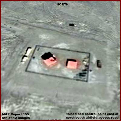
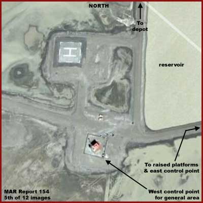
Below the fifth image area is
a east/west raised access road that intersects the north/south raised platforms
access road. From this intersection, it extends off to the left or west to
a water reservoir area with a lone likely inhabited building, a tower, and
a helicopter marked landing pad as seen in the above left fifth image. Heading
east to the right from the reservoir area, the east/west access road also
crosses the north/south access road servicing the platform areas at an intersection
and extends further east deeper into the Carson Sink wastes with the raised
roadway terminating at another inhabited facility as seen in the above right
seventh image.
I suspect the west facility at the reservoir guards the general area main
access and acts as the main communications outpost with the outside world.
On the other hand, I suspect that the east office more directly serves the
raised platform facilities and the square blockhouse type secondary building
on the right there is probably a flight electronics acquisition and control
center.
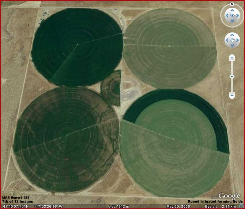
Now some who will be checking
behind me following this report as well as the previous one via Google Earth
will likely be encountering a number of large round forms in out flung areas
like those exampled in the above 7th image. Closer inspection reveals that
these are merely round farming fields growing crops (often premium hay) extending
out from a central irrigation water well and have nothing to do with the evidence
presented here. These round farming fields are also sometimes mixed with standard
rectangular fields.
So don't get confused about them just because they are large and round. On
the other hand, their presence in the surrounding far out terrain may have
influenced the design of the raised round platforms being discussed as evidence
here. The round platforms design may have in part been meant to mimic the
fields hoping that the platforms would be visually confused with these fields
by civilian aircraft passing overhead as well as by spy planes and satellite
distant imaging further above.
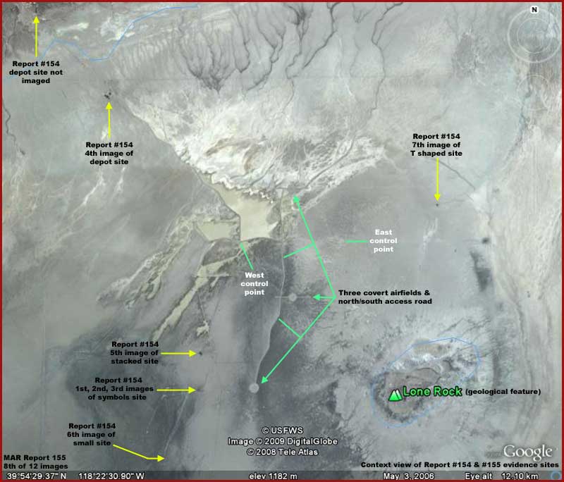
The above sixth image demonstrates
the entire context evidence area. The yellow arrows point out the positions
of the evidence sites in the previous and the green arrows point out the location of the evidence
sites in this report. You can also see the water drains extending down from
the highlands in the top of the image and where the drain water collects in
the larger and smaller artificial reservoir areas as well as where it overflows
at times into the desert terrain south of the reservoirs.
Note the green arrow and white text showing the location of the west lone
inhabited facility with the helopad. A raised north/south road comes down
accessing the reservoir area from the north where the depot sites are located,
turns the corner heading out to our right at the bottom corner of the larger
reservoir at the first inhabited facility and heads east across the bottom
edge of the larger reservoir. Past the reservoir it then crosses the north/south
raised road that accesses the three raised platform sites at an intersection
and terminates east at the second inhabited facility on the right pointed
out with the white arrow and text labeling.
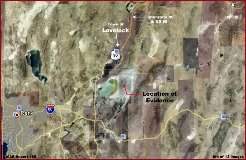
The above seventh image provides
a wider context view to help those of you who wish to check this evidence
out behind me for yourself. Note the major city of Reno in the lower left,
the town of Lovelock, Nevada pointed out with the white arrow and text and
of course the main evidence area pointed out with the red arrow and black
text.
So we've examined some raised roadways and round platforms
in the middle of no where. So what? What does that have to do with anything?
I am satisfied that these hardened durable round platforms as well as the
roadways that dissect them from west to east are, among other things like
electronic targets, dedicated covert airfields for very specialized and highly
advanced aircraft. They are designed as much as possible to not appear to
be airfields from civilian aircraft flying over as they to some extent mimic
the round farming fields scattered in the terrain all around outside of the
evidence area and this part of the country as evidenced in the 7th image here.
However, engineering form must follow function and this gives them away to
an extent telling us a fair amount about them once they're recognized for
what they really are.
A relatively conventional aircraft with shorter strip capabilities can land
and take off from the east/west roadway dissecting the round pad that is really
a more conventional airstrip. The "turn around's" at east and west
ends of the strip reveal the roadway as the runway it really is. It is narrow
and a bit short by conventional combat airstrip standards but note that, if
you can thread that narrow strip needle, you can get along just fine threading
the needle on an Navy aircraft carrier.
It should be noted here that all raised access roadways to the airfields are
almost certainly of the same toughened design and construction as the airfield
strips. That means that it would be possible to use the roadway as an extra
long runway and that would not be good if support vehicles and equipment was
using the roadway at the same time. To prevent this and likely meant mostly
to discourage newer pilot trainees, the designers have caused the access roads
to have shallow zigzag patterns in them at specific intervals. This would
of course discourage new training pilots from attempting on their own to land
conventional aircraft on the access roads as runways. On the other hand, the
various short straight stretches of the north/south access road zigzag pattern
could be pressed into service as landing strips by increasingly experienced
pilots trainees if too strong prevailing winds made landing on the east/west
strips too problematic.
Of course the real interest is not the relatively conventional strip portion
of the airfield. That is just an bonus aspect to its real covert purpose.
It is the huge round raised platform area that is the real interest to us
here. Can't you just see less conventional vertical take off and landing aircraft,
secret aircraft, lowering down on and lifting off that big round pad. Aircraft
that aren't to be seen by prying eyes out here in this sink in the middle
of no where at an old bombing range. Highly advanced and sophisticated secret
aircraft that can easily be confused with UFOs with very advanced electronic
systems onboard, systems that acquire and calibrate to nearby specifically
arranged objects in the terrain that form coded messaging for this purpose.
Beginning to get the picture yet?
In fact, I'll go a step further and speculate that these partially disguised
multiple purpose sites may also be used both for electronic systems location/calibration
as well as airfield purposes by someone who isn't us. In other words, real
UFOs. Want to bet how often some civilian in the wider general outside area
of this sink has seen what appear to be strange lights passing by and/or lowering
down in the distance behind the intervening foothills and mountains that surround
this sink or coming up and out from this area? Some are almost certainly our
secret aircraft but some may be from other origins.
Conventional airfields including military fields always collect permanent
support facilities at the site such as offices, habitats, hangers, bunkers,
etc. as well as aircraft and support equipment. Of course, in these days of
satellite imaging with the eyes in space, such conventional support facilities
give purpose away. The airfields here are designed to be clean of most of
this, to eliminate the obvious, to be as covert as possible, and still be
functional serving only very specialized highly advanced craft that can utilize
the airfield's special features.
For example round and wedge shaped craft with vertical landing and take off
capabilities can take advantage of the round pads. Note that the mid area
and northern pads have short raised extensions off to either opposite side.
These can accommodate mobile support vehicles and equipment off of the main
landing area that leave the site when the need for their presence is over
leaving no long term evidence behind for the eyes in the sky. These can also
serve as work areas for wider than long craft who's side dimensions tend to
exceed the width of the pad.
As I say engineering form must follow function. This and the extremely remote
location in the sink wastes limits how visually covert these airfields can
be in mimicking for example round farming fields.
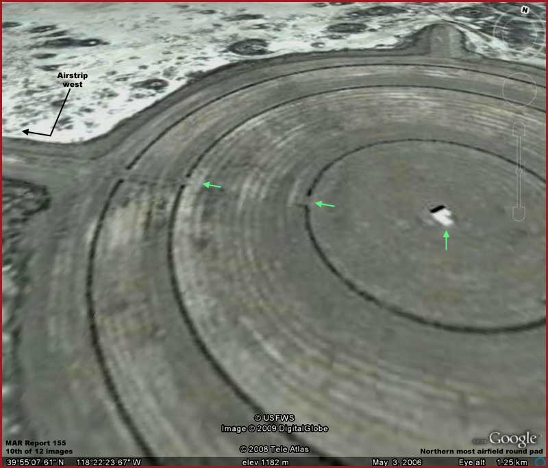
As you can see in the above tenth
image, each of the round pads have at their exact center a highly reflective
object. This object appears to cast a shadow suggesting that it is elevated.
The object is in a fat "V" shape with the point of the "V"
directed west at the time the satellite image was made.
This may be a multi purpose object. It could be a light weight housing over
a hard central core and this outer shell may point into the wind providing
direct observation wind direction information to pilots passing over the site.
It can possibly be retracted into the pad to provide an unobstructed path
for conventional aircraft to cross over in taking off or landing on the strip
portion of the airfield. It may also serve as a refueling and/or charging
station from sources located under the pad. Finally it also likely serves
as the electronic bulls eye of an electronic combat targeting system as do
the pad's concentric rings.
However, never forget that the idea of these three airfields is to be as far
out of view of prying eyes as possible in a time when population density is
so great and people are everywhere here in the USA and then there are of course
the satellite eyes in space to consider. If there is a true UFO connection
with this site, it is doubtful that even military personnel would be aware
of the full implications of the nearby placement sites symbols configuration
or the full covert nature of the airfields except at an upper most level.
For example, this evidence area is under the command of Naval
Air Station Fallon in Fallon, Nevada to the south and known to them
as the B-20 or Bravo-20 bombing range. NAS Fallon is the Navy's premier air-to-air
and air-to-ground training facility including the TOPGUN school. These evidence
sites have long been part of their training area both in bombing and these
days in air-to-ground electronic targeting among other things. I suspect NAS
Fallon exercises use the facilities under discussion here and I suspect that
the placement site symbols are used by them visually as well as in electronic
acquisition and targeting but not physical bombing. The less suspicious person
would say okay, that explains everything, and stop their thinking right there
but that's not me. Let me explain.
Further to the south of NAS Fallon in Hawthorne, Nevada is the immense Hawthorne
Army Depot or HWAD. This is one of if
not the largest ammunition depot in the world with thousands
of bunkers and buildings. It also does a great many other things including
operating as a high desert training facility as well as demilitarizing and
destroying munitions and industrial equipment. As you might surmise, hazardous
chemicals, etc. are among its many things as are of course containers for
this stuff. Obviously one does not move toxic or hazardous materials around
without tough containers.
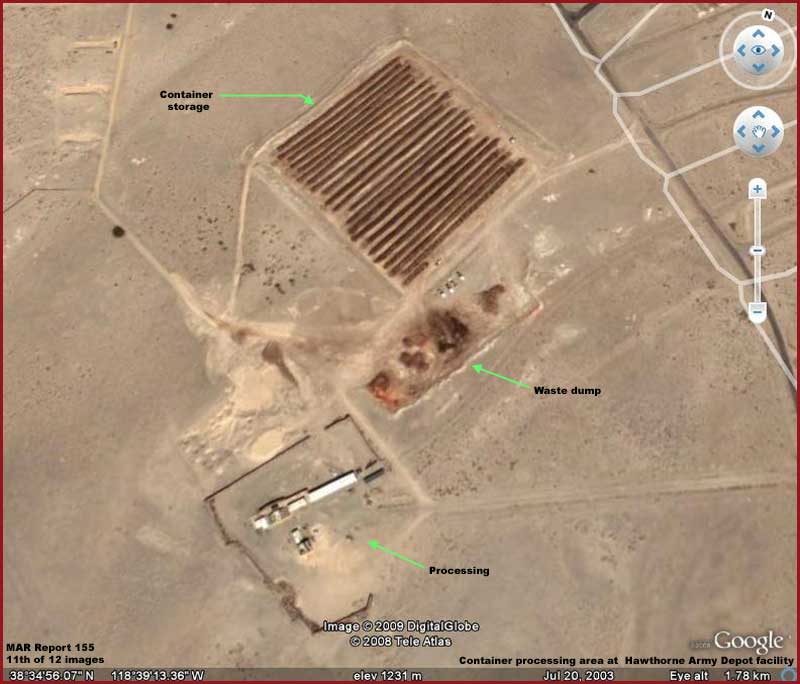
As for the containers subject,
there appears to be a large storage area at HWAD of the same type of rusty
looking containers that make up the placement symbols sites and two depots
in as evidenced by the above eleventh image at HWAD. As you can see,
a portion of the ground at this site is rich with the rusty residue almost
certainly off of these containers suggesting that the one's that are stored
there now are either stored new production ready to move out or up for destruction
and/or recycling.
Please note that this yard is not serviced by railroad tracks and that the
container storage area is very well organized. This tells us that these objects
are transportable by lesser equipment and can be positioned in an organized
manner by that equipment. This is the hallmark of organized component type
storage. That would also be consistent with the evidence objects forming the
symbols in Report #154 and still under examination here.
With this information in hand, it is logical to seriously consider that the
rusty looking cube shaped objects making up the two depots and placement symbol
sites in Report #154 are likely obtained from this not too far away HWAD much
larger depot facility. Further, considering the massive amount of toxic and
hazardous waste the HWAD facility must process including placing in temporary
and longer term storage containers, it is also logical to suspect that the
rusty looking objects in Report #154 may very well have handled hazardous
waste or still contain that waste and give off a "hot" signature.
If so, this would make them ideal signature reference points for very advanced
electronic acquisition systems both from short range and from long range including
from satellites and out in space.
Therefore, not only may NAS Fallon be using these HWAD containers for their
electronic training and targeting systems, high flying spy planes circling
the planet within the atmosphere and satellites in space may be using them
for electronic acquisition and calibration as known fixed "hot"
Earth reference points. If due to their "hot" signature they can
be used by satellites, it then becomes logical that they may also be used
for the same purpose by any space craft with the coded symbols cluster finding
even more meaning in that function and especially if it is already some "borrowed"
alien technology.
Further to the south of NAS Fallon and HWAD facilities and about 65 miles
northwest of Las Vegas is the Nevada Test Site
where atomic bomb testing has occurred since 1951. It is also in the general
location of the super secret Area 51 facility.
The area from this general area up to the evidence sites are geologically
characterized by ridges and dry desert valleys as well as mountains with most
of the ridges oriented north and south and all areas sparsely populated. It
would be just a brief hop by air to the evidence site area from Area 51. Conventional
aircraft could do this relatively undetected flying low in the valleys and
of course aircraft using stealth technology with a small radar signature could
do this even more easily.
As for the placement symbols site, I have been contacted by a person who tells
me that living in Fallon, Nv he was part of the crew that installed the objects
at the primary symbols site from the depot locations to the north. He tells
me that the objects in question are an in completed cardboard or plywood site
for training troops. Another person also from the area tells me that these
are toxic waste containers and that the symbols configuration is used in spy
plane and satellites for instrument recognition and calibration. He says that
these sites are scattered all over and at different elevations for this purpose.
As for the airfields evidence, I'm sure that various parts of the military
would tell us the round shape of the fields appearing as an old fashioned
target is intentional because that is its purpose in acting as an electronic
target for combat aircraft electronic targeting systems calibration and training.
The concentric rings embedded in the mid and northern pads may show up on
instrument readouts to provide feedback as to degree of accuracy while the
center elevated object is the electronic bulls eye.
The point that I am trying to make in repeating these comments by others is
that both the remote placement symbol sites and the covert airfields together
or individually could be used for many different purposes by a number of different
parties wishing to do so without even normally informed others being aware
of it including even under NAS Fallon's eye. Therefore, if some person that
appears to be informed says that the facilities in the middle of no where
are being used for such and such purpose or not being used for such and such
purpose, they may be honest and telling the truth as they know it but confined
only to their limited knowledge and perspective and may not even remotely
encompass the true full covert purposes. It is the nature of very compartmented
covert operations.
So you see how it goes and there you have it. It's some additional information
to go along with and consider. You must decide for yourself whether it adds any insight
or not. If there is an alien connection, and the possibility is there, this
evidence fits in with this website's exploration function and is something
that we should all be aware of.
As for me, the moment I saw those primary placement site symbols in Report
#154, I anticipated an alien language bases as well as possibly a very ancient
language connection regardless of what Earth humans may be currently using
the symbol(s) for. How? Instinct but primarily because of the tight clustering
effect of the symbols that make up the overall symbol. All Earth human learned
forms of communication string out in either a horizontal or vertical continuous
configuration whereas crop circles for example likely form a tight packet
cluster meaning that can be very efficient particularly in very long distance
communication through both space and time without being as subject to corruption
or interruption.
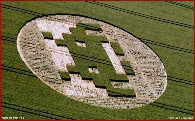
Courtesy of: www.lucypringle.co.uk
Image at: www.lucyprlingle.co.uk/photos/2005/uk205ay.shtml
For example, take a look at the
above twelfth image of a year 2005 crop circle with its rigid block systems
sharing a few similarities with the Report #154
primary symbols. This was sent in to me by a sharp viewer who also picked
up on this relationship. Note that the design is quite plain but also very
balanced. This latter balance factor is always typical of crop circles no
matter how elaborate or complex they sometimes are.
The packet of information and its coded seal are delivered but Earth humans,
after years of trying to understand this phenomena, remain ignorant of any
meaning. Why? Clearly there is nothing coincidental about these configurations
designed as they are to attract our attention. It's likely because we think
and interpret in a strung out linear fashion and someone else doesn't. So
in frustration and for feelings of safety we try to convince ourselves that
two guys with some rope and boards did a crop circle during the night in the
dark even though some of the more elaborate designs obviously would take so
much longer than that to construct with teams of people and with such incredible
flawless speed and precision. Rationalization rules but then so does crippling
ignorance and when was that ever a good thing?
I suspect that the Report 154 evidence symbols are like crop circles in that
they are communication in a tightly clustered rather than a linear strung
out configuration. I suspect that those Earth humans who use these symbols
for different electronic recognition and acquisition and secret purposes are
aware that they do not fully understand them but don't care as long as they
serve their more limited purposes and perhaps even enable the occasional alien
contact (?) via these remote lonely covert airfields out of sight of prying
eyes and without leaving any evidence of it behind.
Come on now, can't you just see yourself as the proverbial mental fly on the
wall covertly observing these sites when heavy obscuring weather patterns
move into this area? Just be sure to come prepared with some extra toilet
paper just in case.
ADDENDUM 1/13/2009
Some viewers are contacting me via email to bring to my attention the
information that the crop circle I've chosen to display as the above 12th
image is an icon from the old Space Invaders game. The implication is that
this is a poor choice for a crop circle and/or an outright mistake because
it is a hoax and fake. There is also an entry in the website Guest Book on
this. So let me clarify.
The inclusion of this particular crop circle was very intentional on my part.
It and the suggestive text associated with it was designed to challenge people
to think. Be reminded that this is a real crop circle and not a false photo
even if the crop circle's physical origins are naturally suspect. Just because
the Space Invaders game icon was replicated in this crop circle does not necessarily
conclusively mean that it was created as a hoax by humans. That would merely
be a too quick assumption unless you know for sure that someone who is not
us has no sense of humor.
Just as with the airfields and the symbols and their more obvious purposes
as likely used by NAS Fallon flight training, one must look deeper and outside
the box than the obvious. This is particularly true in the planetary evidence
business. In fact, in my opinion, deeper even than Area 51 and their UFO disinformation.
It is always important to stay objective. If one stops one's thinking and
search only at the obvious, full truth may forever be elusive because such
truths are intentionally obfuscated and require determined digging to root
them out of secrecy.
It is like an archaeologist digging on a productive ancient site dating back
6,000 years to the known beginnings of civilization. After the site is fully
excavated, the prize (information) revealed, the reputation made, and the
resting on the laurels begins, then along comes some junior wannabe digging
a foot deeper where nothing more is suppose to be and uncovering a 10,000
year old intact library pushing back archaeology 4,000 years. Both revealed
truth but which one will go down in history as the real discoverer and which
the butt of jokes? Which discoverer would you want to be?
Here's another parallel. You're walking down a dirt road and just off the
cleared roadway you see in the bushes a packet of money that turns out to
be a bunch of hundreds totaling to $5,000. What do you do? Do you rush off
kicking up your heels with your good fortune? Or, do you stay calm and give
the entire area a thorough search to find that old briefcase burst open scattering
19 more such packets around it deeper in the bushes? Both scenarios are winners
but which do you prefer?
The Space Invaders icon as a crop circle is a truth but also a distraction
and likely misdirection, always try to look deeper than the obvious. It is
that way with the symbols and these hidden secret airfields. They are more
than they seem on the surface.
ADDENDUM 1/15/2009
Code is a key and especially binary code. Take a look at this link http://amo.net/Contact
as a demonstration. Once that insight is digested, take a look at the crop
circle links below as other examples.
http://www.lucypringle.co.uk/photos/2002/uk2002dl.shtml#pic4
http://www.lucypringle.co.uk/photos/2002/uk2002dl.shtml
http://www.lucypringle.co.uk/photos/2003/uk2003bf.shtml
http://www.lucypringle.co.uk/photos/2004/uk2004cl.shtml
http://www.lucypringle.co.uk/photos/2005/uk2005bd.shtml
http://www.lucypringle.co.uk/photos/2006/uk2006bp.shtml
Note that what we regard as the best defined crop circles are most often applied
in and exist for a short while in perishable crop media under commercial cultivation.
Since they are out in the open and subject to environmental conditions like
weather, etc., their condition can be from pristine to poor by the time images
are taken but never long lasting. The linked examples above represent what
is likely code as their primary message and that can relate to the symbols
code here in this reporting.
However, crop circles convey many additional recognizable as well as unknown
concepts. Some of the known ones we can easily recognize like insects, animals,
birds, faces, numbers, and letters etc. while others are exercises in balanced
geometry both simple and incredibly complex. On the other hand, some crop
circles appear to be purely the celebration of artistic expression in conjunction
with balanced geometry such as the following link for comparison against the
coded data.
http://www.lucypringle.co.uk/photos/2008/uk2008be.shtml#pic4
Despite the human hoax aspect trying to muddy the water on crop circles, some
of these are obviously designs backed by highly sophisticated intelligence
of some kind and some of it just as obviously isn't us. Some of them are also
obviously messages meant for us or someone else or both. Just because we cannot
yet understand what is going on here is not a reason to dismiss or retreat
but a reason to stretch our intellect.
DOCUMENTATION
http://earth.google.com: This link takes
you to the Google website page for downloading the Google
Earth 4.3 program. This will be necessary to do Google Earth searches
of this site in Nevada, USA.
http://mapsof.net/Nevada: This link
takes you to online page where you can use the same satellite imaging of Nevada
that Google Earth uses and without downloading a program.
I have confirmed that the same evidence is available here.
, Investigator
www.marsanomalyresearch.com
![]()