
MARS STRANGE BIO-LIFE-2
Report #146
September 6, 2008
Very large image files—slow loading on dial-up connections!
This report is a supplement to the
last Report #145 and covers the
same subject matter. That means that this report depends on viewer familiarity
with that previous reporting content, so go back to that report at the link
provided here if you are unfamiliar with that report's content.
In that last report, we covered MRO evidence that is viewer friendly and viewer
verifiable in the science data browser compatible .jpg imaging to make sure
that there is no doubt about the verifiability of the evidence. This
report covers some of the same major form evidence but now drawn from the
higher quality JPEG 2000 or JP2 imaging that is not browser compatible and
requires jumping through hoops via the installation of Java and the proprietary
IAS Viewer in order to verify it in the official science data.
Just to give you an idea of the difference between the browser
compatible .jpg and this non browser compatible JP2 imaging, the Report #145
science data .jpg source image file size is 13.9 MB while the JP2 downloaded
file size for this Report #146 in Windows is 892 MB taking over an hour-and-a-half
download time on a broadband connection. In other words, the JP2 image is
a whopper at slightly over 64 times the file size of the browser compatible
.jpg image.
Now that does not actually translate into 64 times the resolution
but it is a considerable improvement allowing closer views of the evidence.
Further, the less often examined JP2 image, in this particular strip's case,
has less image tampering in it to obscure information than the more commonly
available .jpg images.
In my opinion, the use of the proprietary JP2 files and the special IAS Viewer
serves two basic purposes. Most obviously and in theory it provides scientists
and academics that do not have graphic software programs on their systems
with a fairly simple ready made free download and view capability after jumping
through download and installation hoops. However, that is essentially only
a view the data the way they want you to see it capability.
Now why isn't that a surprise.
This ignores the fact that there is a very good free
graphics software program called GIMP
with the greater versatility of full view, correction, and image manipulation
capability similar to PhotoShop that is also extensively used by scientists,
academics and university systems and can be used by everyday people as well.
The science data could have been presented in the more common .jpg, .gif,
.png, or .tif, file formats that graphics software programs can recognize
and deal with. However, then the observer would also be able to independently
sharpen and clarify evidence as well as rotate and flip it for examination.
Now why isn't it a surprise that the IAS Viewer software will not allow that.
So the complexity and difficulty of the JP2/Java/IAS Viewer hoops effectively
act as controls and barriers to more in depth examination of the science data
rather than enhance the experience. Even most scientists or academics scanning
the data will tend to choose the more obfuscated browser compatible .jpg data
to avoid the hoops complexity just as will the great bulk of general viewers.
So the barrier hoops also act as psychological tactic that bends interested
parties away from better more complete examination. Chance, incompetence or
intent? You be the judge.
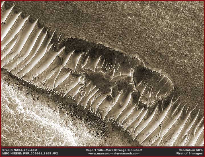
The above first image demonstrates
mixed together in the same scene both of the most major forms of evidence
in the previous reporting. That would be the pit evidence in the center of
this image and the parallel ridge form very light reflective evidence extending
from the upper left corner to the lower right corner edges. You should know
that higher ground is represented in the lower left corner and lower level
terrain is in the upper right corner. The evidence spans across and down the
length of a long cleft in the terrain extending far out of sight to the left
and right of this scene.
This means that any shallow water presence here flows from the bottom of the
image toward the top. That in turn means that our orientation view
perspective isn't a very good or comfortable one here. We're sort of looking
from the top backside of the site from bottom to top perspective. I could
have flipped the image to provide a better perspective but I didn't dare because
the perspective changes again with other evidence sites in this strip where
the slope angles change and I did not want to add confusion for anyone checking
and verifying the evidence behind me in this JP2 image.
The pit and ridge form evidence visually speaks for itself here if you are
familiar with my previous reporting. What I really want to draw you attention
to in this scene is the many small narrow parallel striations complete with
dense knobby patterns within them on the top side of the pit and ridge form
evidence that could not be seen in the previous report's browser compatible
.jpg imaging. They are still very distantly seen but this is another new now
apparent aspect of the bio-life presence on the downhill shallow water flow
side. Note this new evidence's absence on the elevated opposite near side
slope (bottom left) dominated by the ridge forms.
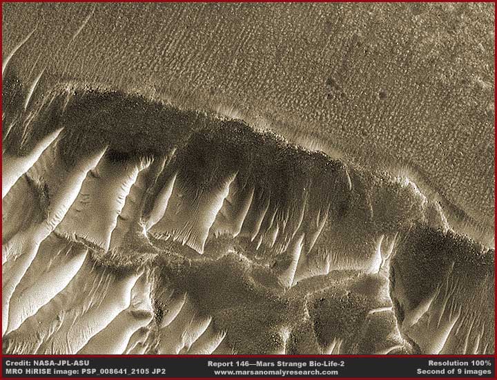
The above second image provides a closer view mainly of the pits area in the first image and the knobby parallel row striations evidence. Note that the pit walls appear to be made up of some kind of darker color finely textured knobby living growth. Let's face it, it is pretty hard to pass any of this off as some form of strange inanimate geology. What I suspect is happening here is that the row striation growth in the top of the image is in the process of overwhelming and engulfing the heights of the now mostly defunct deteriorating pit evidence and via this foothold is making a little inroad into the ridge form evidence as well.
The above third image demonstrates
of section of a long line of the pit evidence jammed up side by side against
each other. Note the lesser ridge form evidence on the near side and the even
more faintly seen small parallel striations evidence on the nearer side of
that. On the other hand, please again note the absence of an ridge forms or
striations evidence in the up slope terrain above the line of pits and how
rough and porous that higher level terrain looks.
Here the view is of the higher terrain in the top of the image working downhill
across and dropping down the cleft and into the lower level terrain in the
bottom of the image. Any underground water table presence would be flowing
down this terrain from the top of the image to the bottom. This orientation
of the sloping grade in this site area also provides a more comfortable view
perspective.
Now I want you to take special note of the way these pits back walls snug
up against the back cliff wall of this cleft system. Remember that the higher
level terrain is in the top of the image and the lower level terrain is in
the bottom of the image meaning any water table presence would gravity flow
from the upper level terrain to the lower level. That would include emerging
from some point in the cliff back wall height and flowing down it.
With that thought in mind, note how high the pit back walls are as they snug
up flush to this cliff wall relative to the opposite near front pit walls.
What is going on here is that the pits aren't just pits digging into the cleft
line bottom but mainly constructs building up plastering to the cliff back
wall. In other words, what I'm referring to as pits for the lack of a better
term are likely forming vertical water filter systems against the cleft's
cliff back wall and any water presence is probably coming through those pit
back walls as opposed to over them.
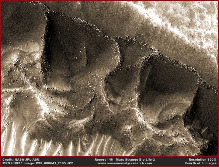
The above fourth image provides a
closer view of a section of the line of pits. Here what I want you to do is
look very close and primarily take special note of the surface texture patterns
that are most pronounced on the pit back walls as they press against and conform
to the cliff wall. Note that this texture pattern is for the most part confined
primarily to the back walls and that is also where the pit shape is the most
well defined as compared to the more irregular side and frontal areas.
Note that the frontal (near side) areas are considerably lower than the back
walls and essentially open. The point in this latter observation is that the
purpose of these pit formation, just as with the parallel ridge form formations,
is not to hold onto water indefinitely but to pass it through their filtering
systems. In other words, via these vertical formations (and horizontal systems
in the case of the ridge forms), their purpose is likely to filter some organism
out of the Mars water that sustains their life.
 ..
..
.............Photo by: Austin Reed ...............................................blog.snappingturtle.net/archives/date/2007/08
Pacific Wildlife Foundation ......................................................(scroll
half way down the page)
www.pwlf.org/graywhale/behavior.htm........................................................................................................
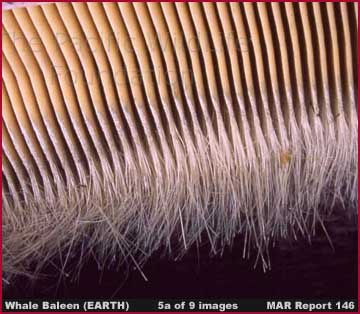
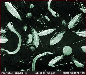
A very rough parallel example here
on Earth might be something some what similar to the purpose a whale's baleen
as shown in the above left 5a image serves in filtering tiny organisms like
plankton
as shown in the above right 5b image as well as krill, fish, etc. from
Earth's ocean waters. Of course a mobile whale cruises Earth's oceans to place
itself where the organisms are more plentiful to feed and then moves on while
the Mars evidence finds a strategic location in the Mars terrain and permanently
plants itself there to feed as long as the conditions permit.
Note that here on Earth, a great variety of coral polyp colonies also place
themselves permanently in strategic locations in Earth's oceans to filter
sustenance from tidal water flow passing over their fixed positions and forming
massive reef systems in the process. This begs a question. Is this Mars bio-life
evidence some form of ancient coral polyp colony life adapted over the ages
to less and less water on the planet's surface? It's a thought.
The texture pattern on the pit back wall is typical of this bio-life evidence
when in contact with water. All over Mars ice mass after ice mass is transformed
into surface texture patterns similar to this. You'll see another example
of this in the last 9th image in this report. However, remember that we are
talking about water ice in a solid state and not pooling liquid water. This
type of evidence in its various derivatives cannot form in this way within
pooling water but can have a limited presence in water ice solids.
The main thing that is happening here is that this "pit" life form
plasters itself to the back wall acting as a filter system as evidenced by
the location of the pronounced texture patterns. However, because this formation
is vertical, very tall, and gigantic in size against the back wall, it likely
requires reinforcing in order to maintain this massive vertical configuration.
When pooling water is not present, reinforcement is accomplished by periodic
buttresses forming at 90º angle to the back wall forming the pit side
walls. The two buttress wings then wrap around and join in the lower level
frontal area forming the pit looking shape and to some extent a secondary
water filter in the pit frontal area. The giant pit evidence you are looking
at here in this strip is no doubt very old and very long established.
The filtered water makes its way through the pit line primary and secondary
filter systems out into the downhill lower level terrain below the line of
pits. There the ridge form and smaller striation evidence form to take advantage
of this. However, unlike this kind of evidence in the next image below, they
cannot get all that large or plentiful because the nutrients in the water
have been reduced in the process of coming through the line of pits in the
cleft filter systems leaving them with poorer residual feeding.
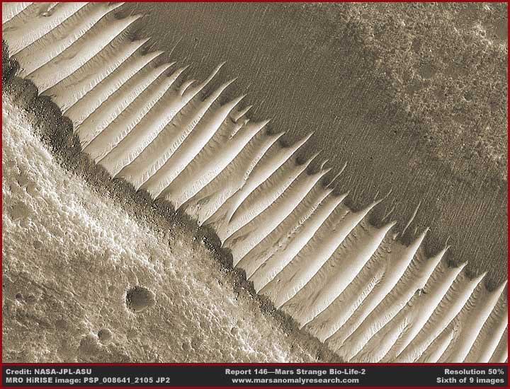
The above sixth image moves us on
to a better look at some very large ridge form evidence and the associated
but smaller striation evidence. As you can see, the very light reflective
ridge forms are huge and obviously the most dramatic looking.
Here, once again, higher terrain is in the bottom of the image and lower level
terrain is in the top of the image. Any water presence would be flowing from
the bottom of the image through the ridge form and striation evidence areas.
Again, sorry about this orientation perspective but I did not want to flip
the image to provide a more comfortable view and risk creating confusion later
for those trying to check behind me in the JP2 science data.
I suspect that the ridge form evidence here specializes in forming where water
flow is perhaps a little more intense and the down hill slope just a little
more gradual relative to where the more vertical orientation pit evidence
adaptation is best suited. The horizontal configuration handles these factors
a little better. The main ridges are high and parallel to each other and are
all oriented in the same direction as the water flow. The water is channeled
between the ridges and through the blocking rib filtering systems you can
see in the troughs between the ridges that prolongs water contact and thereby
the filtering process.
The smaller striation evidence, also oriented in the same down hill direction,
makes due with the left over water after it comes through the big ridge form
filter systems. It is unclear whether the giant pit and ridge form as well
as the smaller striation bio-life evidence are all the same merely taking
on different configurations to adapt to different sites or whether they are
all different species that feed in the same way by filtering water. Either
way, a point to made here is that water and its content is the key.
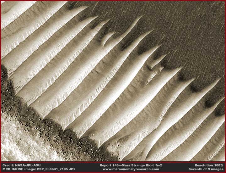
The above seventh image provides a
closer view of the light reflective ridge forms. As you can see very well
here and as you know doubt have already been noticing, each of the many ridges
has a knife sharp top that looks very much like the sail fin of some ancient
creature or a serrated knife blade. Unfortunately the parallel row striation
evidence in the image top area did not benefit that well from the closer view
because they are just too densely packed to be able to pick out any real individual
detail.
Obviously this is not inanimate geology but bio-life of some strange kind
at work and almost certainly cooperative colony life. It is no accident or
coincidence that the pit evidence, the parallel linear ridge form evidence,
and the smaller parallel row striation evidence clusters to this crack or
cleft system in this terrain right where water table presence would tend to
collect as it moves via gravity from elevated terrain across and down the
cleft and into the slightly lower level terrain the other side of the cleft.
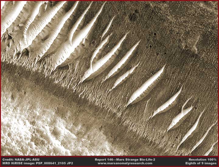
The above eighth image demonstrates
the end of the long line of the giant size light reflective parallel ridge
forms. As you can see, they are no longer packed together side by side in
density but now more spaced out from each other, isolated, and getting progressively
smaller as the eye moves from left to right. On the other hand, the also much
smaller parallel row striation evidence can now be a bit better viewed. Note
how the base of the striations on our near side tend to anchor in the terrain
along a well defined boundary line just as the ridge forms do.
Could the striation evidence be a precursor form of the giant ridge form evidence
or just another different life form able to take advantage of and competing
for any water presence in the cleft system? At least the higher detail of
the MRO imaging and absence of so much image tampering has allowed us to now
be aware that the smaller parallel striation evidence does exists where the
ridge form evidence exists.
I doubt that the secrecy agenda meant for that to happen likely preferring
to believe that no one would figure this out and just pass off this collective
evidence as strange and inexplicable. However nothing is inexplicable, only
in need of understanding.
Still think you are looking at some kind of strange geology? Again, remember
that all of the above evidence is clustering to the long terrain crack or
cleft system. Likely underground water on the higher terrain side of the system
is flowing down hill into the cleft. As it flows toward the cleft system and
the lower level terrain on the other side, all this evidence is capitalizing
on this water presence and filling this niche. Remember, life always finds
a way.
When the flow is stronger in the cleft area, more dependable, and down a more
gradual slope, the ridge forms dominate channeling the water down slope through
rib systems that radiate out at 90º to the main ridge forms as seen in
the ridge form troughs as seen in the 7th image. On the other hand, when the
flow is less but still dependable and coming down a little more vertical slope
in the cleft, the pit evidence grows its filter system plastered against the
vertical cleft wall on the up slope side establishing irregular buttresses
all along the filter walls giving a pit like appearance as they wrap around
irregular and lower profile on the down slope side.
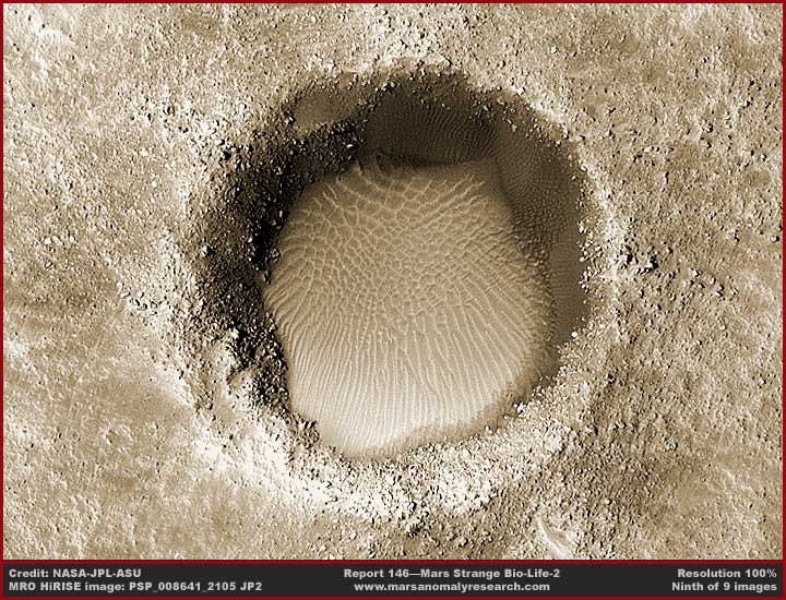
The above ninth image demonstrates
a round hole in the terrain with light reflective water ice all over its bottom
area. This is one of the several holes of water in my previous Report
#145. This sample demonstrates that there is underground water presence
in this general terrain and not too far below the surface.
More importantly, note the texture pattern in the ice that could not be adequately
seen in the previous Report #145 .jpg imaging. This is what I mean when I
describe that ice mass after ice mass surface is more often than not transformed
in this way all over Mars. Note that some of the patterns in the upper part
of the ice take the shape of defined closed cells while some of the patterns
in the lower part of the ice take the shape of parallel row ridges.
Almost certainly the ice mass is elevated a bit where the closed cell structures
are located. Where the many parallel linear ridges are located is lower level
with a down slope to it. When the ice melts on the upper level surface due
to environmental warming and/or solar impact, water runs down these ridge
channels to return into the terrain at the near bottom sides of the hole.
Likewise, look closely and take special note of the dark color texture pattern
on the hole's walls from the 12:00—3:00 O'clock positions or upper and
right sides. Note that it is the same as on the back walls on the line of
pits, just on a smaller scale here in this long hole. Now note that this dark
texture pattern evidence is not present anywhere else along the hole's walls.
Without a doubt where this texture pattern is located is where the water is
entering this hole through the underground water table and this is where the
dark texture pattern filter system is at work plastered on the vertical walls.
The filter system is thin and not buttressed up here. Why? Because water has
pooled in the bottom of the hole and the buttresses cannot form adequately
there.
I realize that all the concepts presented here and in the previous report
are very new and strange to the Earth human experience that will without a
doubt encounter knee jerk psychological resistance. However, this is of course
a different world with its own unique developmental paths. Surely you scientists
and academics knew that there would be differences and sometimes dramatic
ones even as there are similarities?
Instead of reacting with fear and preprogrammed disbelief, think of it as
a unique opportunity to explore something really new and determine its merit.
Don't leave this to amateurs to steal your show. Remember, an increasingly
aware audience of intelligent people now measuring in the millions around
the world are watching you and waiting on you. No response or involvement
at all merely condemns you and your community to irrelevancy.
DOCUMENTATION
http://hirise.lpl.arizona.edu/PSP_008641_2105:
This link takes you to the official science data HiRISE MRO PSP_008641_2105
image strip page at Arizona State University. This is the official site and
it has both the browser compatible .jpg imaging used in my last Report #145
and the not browser compatible JP2 source images used here.
Remember that the JP2 images are not browser compatible and will require the
official "IAS Viewer" installed on your computer and to do that
will also require an updated form of JAVA. The evidence in this report was
drawn from the "JP2 Products (Download)" section in the right vertical
column and the image there has a listed file size of 935.4
MB. That image download was about 1.5 hours in Windows via a fast broadband
connection with an actual final file size of 892 MB.
I thought it was worth it.
NOTE: If you aren't able to work with the full JP2 image strip, you can still
take a decent look at both the pit and ridge form JP2 evidence as browser
compatible. At this official site, there is a large black and white image
of the pit evidence in a section in the right vertical column labeled"Subimages
in this Observation." Likewise there are nine false color images of the
ridge form evidence from 800x600 pixels to 2560x1600 pixels in the section
in the right vertical column labeled "Wallpaper." I did not draw
any evidence from these but they are drawn from the JP2 imaging and are browser
compatible.
, Investigator
![]()