
MARS SATELLITE IMAGE ILLUSIONS
The Art of Misdirection & The Unreal
Report #126
September 15, 2007
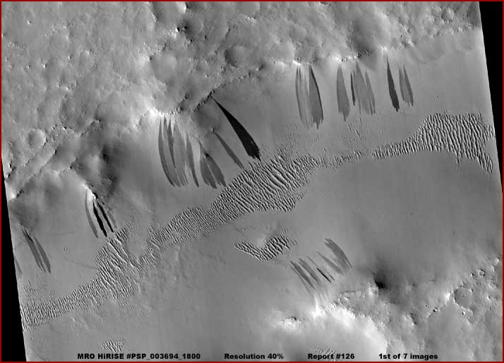
The above first image and the next three below are from the MRO HiRISE #PSP_003694_1800 science data image. As you can see, it is a wide-angle context view inclusive from one side of the strip to the other. The scene is beautifully clean and clear looking with a silky quality to it and that is so typical of the very high resolution current MRO camera system images. The MRO stats on this image indicate that this scene is located in Terra Sabaea south of Janssen Crater but that really isn't important to us here.
As you can also see, the darker streaks relative to the lighter color background are the scene's most eye catching feature. In the more current MRO data these are described as "slope streaks" which is a rather neutral identifying moniker in relation to the previous characterizations of this evidence. In previous science data, these have been consistently officially described as dust slides down slopes. The theory is that the upper soil material slides downslope revealing darker geological material underneath. These characterizations of course reinforce the official position that Mars in general is a super dry, dusty, dead world.
You should perhaps also know that some lay researchers in the field have identified these as water weeps but of course that, as you might well imagine, didn't get far in the traditional mainstream science communities who rarely deviate from evidence official designations once they are made. Now in the over seven years I've been doing this, you might note that I haven't reported on this type of evidence. Why? Well I usually don't report on geological evidence because most of the time I leave that to the geologist unless I believe they are too far off base. However, that's not my reasoning here. I haven't reported on this simply because I don't buy into this evidence at all.
For example, in the above beautifully clear scene, note all the smoothed textures on everything giving it that silky look. This isn't the way geology looks and particularly not in satellite imaging with the very high fine resolution touted in the MRO imaging. When it comes to rough geology, we should be seeing many times the geological detail we are seeing here. Any professional worth his salt who has examined satellite images of Earth's geology even in 10 and 20 year older satellite camera technology will have to admit that and it isn't because this is super dry dusty Mars either where geology is covered by dust.
All one has to do is take a brief look at the Spirit and Opportunity rover imaging when the surfaces of the rovers are shown. After many months and even some years trekking around on the Mars super dry "dusty" surface, the rover hardware surfaces including all of the onboard great many nooks and crannies and dirt catchers are pristine clean. Either the rovers in these particular images are not on Mars or, if one argues that they are, then Mars just clearly isn't all that dusty, at least not to the degree as portrayed here in this MRO image. You just can't have your cake and eat it to as the saying goes.
In my opinion, what we are looking at in this scene is a demonstration of the art of misdirection and illusions of the unreal. We are looking at everything being covered by map type smudge image tampering from one end and side of the strip to the other. It is applied thin enough in places so that the rougher natural terrain can print through a bit to the surface giving the scene the vague washed out look of geology. The streaks are added for effect as eye candy for the researcher's eye to lock onto rather than be faced with image after image devoid of any such detail and thereby slowly raising inconvenient questions.
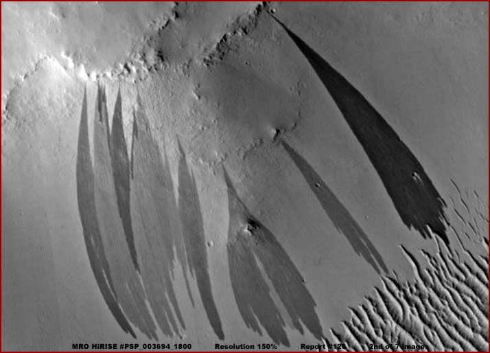
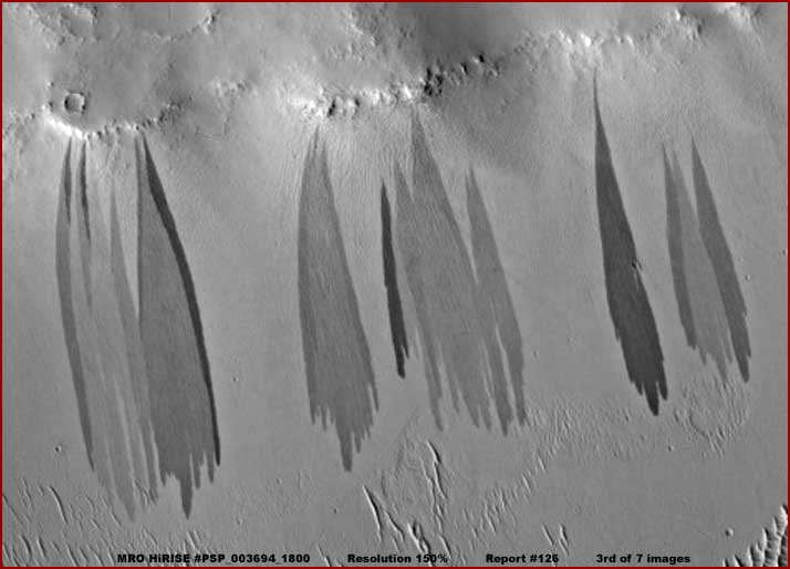
The above second image with its view to the left and the third image with it view to the right from the same MRO strip provide a closer of the areas with the primary streaks in the scene. As you can see, the illusion continues to hold up very well in these substantially closer views. That's because the much greater camera resolution has enabled and allowed the tampering applications to now occur at a much closer and finer level relative to the past and then the scene is drawn back to the distance you see here for the desired effect.
You have to understand that we aren't dealing with a home computer here or even some huge commercial computer and some commercially available software that does nothing more than what the user tells it to. I have always been satisfied from the beginning that we are dealing with super fast computers run by cutting edge proprietary state of the art and steadily evolving AI (artificial intelligence) technology capable of learning and making its own extrapolations and decisions (with a little help from its support group) and using proprietary cutting edge and steadily evolving combination object recognition and mapping type graphics software to implement its actions in processing and "fixing" the incoming data.
I wouldn't be a bit surprised to learn that in these more modern times a master system and its redundant backups control many other systems in this process including systems reviewing and checking behind systems and redoing images that need it. The raw specially encrypted so it can't be intercepted data comes in under strict secrecy to this location first, is processed, then encrypted again to match the original design science encryption, and then likely bounced back off of the Mars satellite to come into the normal and waiting Earth computers systems appearing for all the world like the true raw science data but isn't really and no one is the wiser.
That's because the straight well meaning scientists thinking simply doesn't track along this slippery line as those do in military, security, and intelligence work. We're exploration scientists associated with university systems and here is the science data just as we expected it and from the source we expected to come in from, even if a little disappointing in lack of hoped for detail. So what's the problem? They just ignore the very obvious fact that NASA and JPL and so many others associated with this science are riddled with people right to the very top that either have direct military security and/or intelligence backgrounds or are civilians that have long worked with military security and/or intelligence developing a "cooperative" relationship with it.
No, it just can't be, it's just too fantastic and, like Scarlet's character in the movie Gone With The Wind, I can't think about that right now or I might add ever! So a pattern of ignoring it develops that communicates down through the subsequent generations of otherwise bright and intelligent scientists conditioning and corrupting them thoroughly in this manner. Meanwhile, over decades the true raw data and its very important and useful information is retained in secret somewhere for only an elitist few to have knowledge of and try to figure out a way to capitalize on while the general science and academic communities and through them the public get the nice safe appearing sanitized placebo material to float along with thinking everything is okay and well in hand.
The process necessarily conditions ignorance and non thinking into the populations to keep them passive and non interfering so that subsequent generations focus more and more on shallow matters and become more and more detached from reality and even recognizing what that actually is. The process also conditions the subsequent generations of secrecy elitists more and more into isolation so that eventually they have no feelings of commonality with the general populations and come to regard us more and more as merely a resource to be capitalized on, manipulated without qualm, and perhaps even expendable. Does this sound like a good thing to you? It doesn't to me.
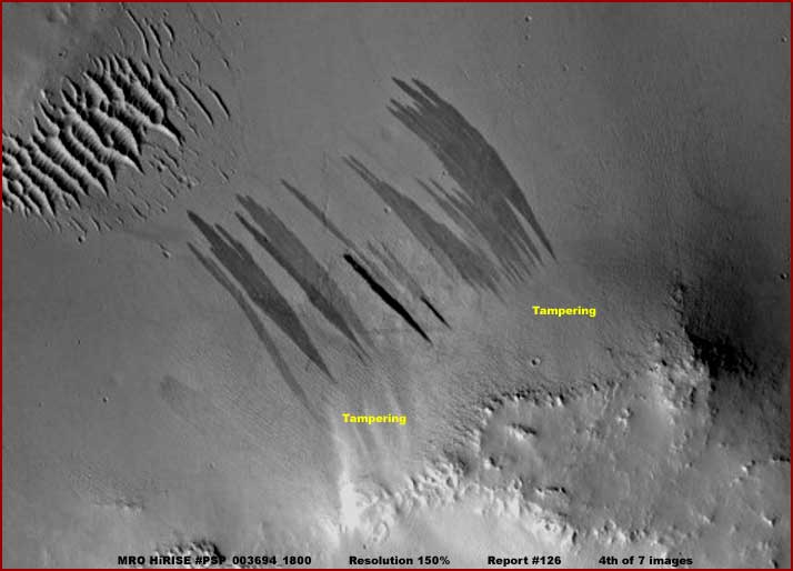
In any case, the above fourth image from the same MRO strip is the site a little lower down in the first presented context image. The only thing this scene tells us beyond what we are suppose to see is that some spot tampering applications as represented by the yellow text in the above image were applied after the streaks were applied and on top of them ever so slightly overlapping the tops of the streaks and very subtly only in that way revealing themselves in the process. This demonstrates that first the basic tampering was done applying what becomes the smudge general background, next the darker streaks were applied on top of this background as the eye candy to catch and misdirect the eye, but something was still coming through in these spots on follow-up and so secondary spot applications of matching smudge labeled in yellow text were applied.
Unfortunately these few very subtle clues are all that we have now as evidence of the presence of the map type tampering and obfuscation of this newer MRO imaging. One has to understand that the tampering technology has had a chance to evolve and fix its mistakes over the years and become much more effective and particularly with respect to creating illusions and thereby misdirection. Further, this tampering progress is significantly enhanced by the ability to make the applications down at minute size scales never admitted to so that when the image is drawn back to the publicly released much more distant scale, such applications are very difficult to detect as you can see above.
As for true color images, they are of course more difficult to obscure because it makes evidence stand out familiar to the eye. That means it can't be allowed and any future substitute to pass off as original must be very good and well beyond the ESA artificial colorized imaging. Rather they use the real color imaging to gather data for their own secret purposes as well as stock pile hundreds of thousands of color images into a database that will go into making the next generation of tampering using color as effective as needed to pass off as real.
As this map type tampering technology progresses, the colorizing aspect will soon reach the level, if not already, where they will feel confident that artificial color can be applied with a sufficiently realistic effect and then that addition more easily passed off as the real thing in future imaging. You can count on it! I'm satisfied that the real unobfuscated true satellite imaging raw data held in secret somewhere has been in color since at least before the MGS MOC data probably at least as far back as the Clementine Moon data and most definitely includes the current MRO data. We are never going to see it unless they feel that they have no choice but to allow it.
That is where the Planetary Truth Project will eventually come into the picture to do something about this. Meanwhile, I digress. We've seen the slope streaks in the MRO imaging, now lets see some of the same type of evidence in the older MGS MOC imaging as appears below for comparison purposes.
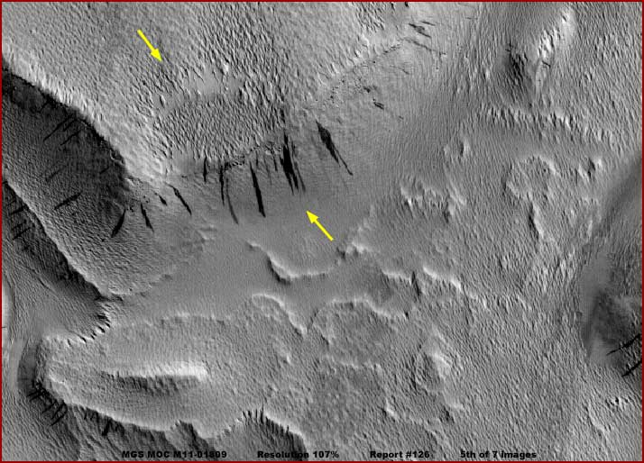
The above fifth image is a context view from ones side edge of the 1/2000 M11-01809 strip to the other. It is the same story as in the previous 5/2007 MRO imaging. The tampering in it is just as extensive and just as illusional but just not quite as well done because the older camera technology doesn't yet enable it. The yellow arrows point to the evidence area that we will be zeroing in on in the closer images below.
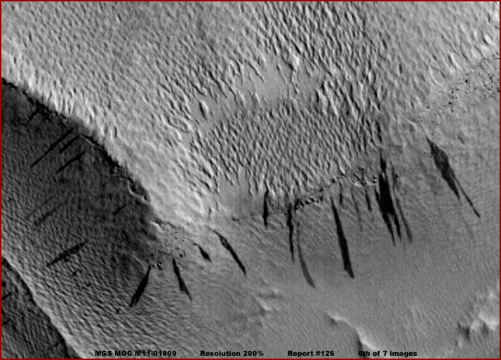
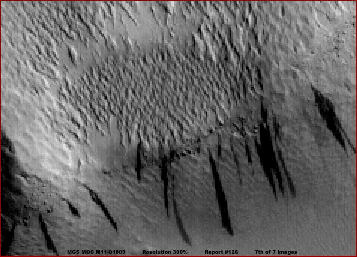
The above sixth image at 200% zoom and seventh image at 300% zoom are from the same M11-01809 strip. Although the seventh image at 300% zoom factor is slightly pixelated, the degree of pixelation only enhances the patch of row type geometric forms and does not outright create them. This is poorly seen and therefore weak civilization evidence that the extensive smudge image tampering is for the most part effectively hiding throughout this strip. It is the row patterns this weak evidence is in that tells me it is civilization evidence and not just the geometric patterns.
Truthfully I normally do not report on evidence this compromised and weak. However, it doesn't matter whether you accept this as weak civilization evidence or not. This isn't really a report about this as civilization evidence, so just ignore that as a factor here. Rather, in the above seventh image, I want you to concentrate on the texture patterns. Note the rougher texture patterns in the patch of rougher looking geometric forms and the direction of the row patterns. This evidence is suppose to be on top of an elevated plateau at the edge where a slope drops down into a lowland. The dark streaks are suppose to be dust slides starting near the top of this slope and sliding down it reinforcing the perception that there is a slope here.
But, now look very closely at the top of the slope all around the dark streaks and you will see a very faint rough texture pattern that is also in rows. In fact, if you've looked carefully enough, you'll see that these faint texture pattern directional rows on the slope roughly match those of the geometric evidence on the plateau. In fact, they are one and the same evidence but with subtly different tampering application fields on and obscuring them to make it appear as though there is a transition from an elevated plateau at the edge and down a slope. In other words, via shading of the smudge, the false visual that there is a slope here is created and it really isn't there all.
But, that isn't all. Now note the clear consistent directions of the dark streak dust slides. Note how they cross diagonally across the directional rows background beneath them without be deflected by the row patterns. Even if one assumes that the background under them is just geological slope material, it clearly has a rough enough texture and direction to it to deflect some or all of these gravity based soil slides. The fact that it doesn't is significant and telling. Out of all these many "dust" slides both larger and smaller, at least some here would have been deflected by the rough row geology beneath them. In other words, the dark streaks here are themselves not real.
The dark streaks are the strong obvious eye candy to attract the eye and along with false shadings that create the illusion of slopes misdirect attention via illusion away from the background that is where the real evidence is at and its obfuscation. In other words, see the birdie in this right elevated hand jumping around in your face while the knife with the real goods comes in down low and covert out of sight in the left hand. It's the can you guess which shell the pea is really under game where misdirection is the primary tool.
The point is that this subtle illusion and misdirection tactical has existed at least the past 7+ years or more in the MGS MOC data having the time necessary to improve more and more over those years. So you can perhaps imagine my reaction when I see these dark streaks appear on top of all that fake smoothed background in the current MRO imaging that is suppose to be so much better. Well it may be true that the real MRO camera imaging not released for public consumption is much better, at least where ever the real color data really is, but the evidence itself as publicly released in this black and white imaging is no better, only better created.
You need to understand that these wholesale obfuscation's and illusions have never served just a simplistic function of covering over and hiding specific evidence alone. By their extensive use covering over even vast amounts of harmless geology, they sculpt a general perception of a planet and train the researcher's eye in what to expect as "normal" on the planet surface in future offerings. In other words, they get inside heads and condition responses and are a form of very subtle mass mind control. All to protect secrets for a select few and that are never shared with the public who paid for them and enabled the acquisition of this secret information.
Anyone who can convince themselves that this pervasive manipulation is a good thing for the public welfare needs to be taken out behind the barn for some special "education." Likewise, those who pretend that this type of thing isn't going just because they can't psychologically face it, need to wake up and smell the planetary roses of truth.
As some of you know I don't like doing this tampering only type of reporting. However, my point in doing so here is to demonstrate the extent of and just how pervasive and extremely subtle this business is, that it gets more and more effective over time, and reiterate that not much can be expected out of the MRO imaging unless a rare mistake made in the obfuscation process reveals it. In the MRO imaging, such tampering mistakes are a lot fewer than with previous probes.
DOCUMENTATION
http://hirise.lpl.arizona.edu/PSP_003694_1800: This link takes you to the official MRO PSP_003694_1800 science data image strip access page that is the source of my first, second, third, and fourth images here in this report.
http://www.msss.com/moc_gallery/m07_m12/images/M11/M1101809.html: This link takes you to the official MGS MOC M11-01809 science data image strip access page that is the source of fifth, sixth and seventh images here in this report.
, Investigator
![]()