
MARS RECONNAISSANCE ORBITER EXPECTATIONS?
Report #094
October 17, 2005
11/7/05 Update at bottom of this report
As of August 12, 2005 the newest probe, the Mars Reconnaissance Orbiter (MRO), is now successfully on its way to Mars. After a seven month trip arriving on or about March 10, 2006 and, if things go well, there will then be another six or seven months of aerobraking fine orbit adjustments after that. This latter is to achieve a closer than before orbit around the planet of about 186 miles (116 km) out compared to an average of about 230 miles (143 km) out for the previous still operating MGS MOC craft. When this optimum orbit is reached, then its science survey work will begin in November, 2006 producing the mission's primary data return.
Why am I talking about this and how does this relate to the visual evidence in this report? Well of the many science projects on board the MRO, there will be a camera known as HIRISE (High Resolution Imaging Science Experiment) with the largest telescopic lens ever sent on such a mission. This telescopic camera/lens combined with the lower closer orbit factor as stated by NASA will produce images of objects down to 1 meter (3.2808 feet) or as NASA states down to the size of kitchen/dinner table compared to the stated best MGS MOC imaging of down to the size of a school bus.
Obviously such high detail imaging, if its true results are ever legitimately made available to the public, would have immense implications for determining what is really on Mars. Yes, off world imaging technology is swiftly evolving and advancing. I have no doubt that these MRO camera resolution statements are just as true as they were for the the earlier MGS MOC systems. However, another question is whether this real advanced data will actually be released and shared with the public who paid for it as required by law? Remember, while advancements are steadily being made in imaging technology, advancements are also being made and keeping pace in computer and software image obfuscation technology as well.
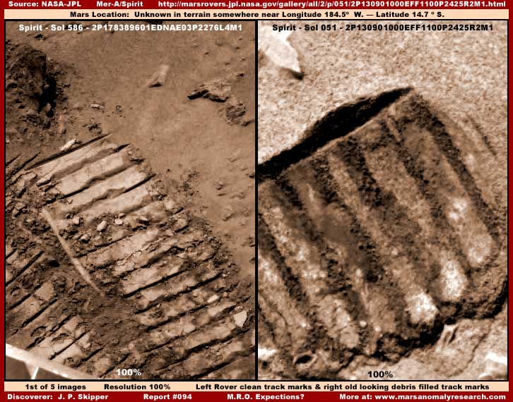
For example, as I have made known, in my opinion, the Spirit and Opportunity rover Mars imaging as a whole is severely sanitized of legitimate information and objects there are often only a few feet away from camera systems suppose to have also set new advanced resolution heights. In the above first split screen image, note the rover tread tracks on the left compared to those on the right. Note the smooth and generally sharp definition of everything in the left split image relative to the grainy texture of everything in the right split image of a different set of tracks in a different image. Note that the tracks in the right split image image look older with the deepest darker tread indentations apparently filled in with small sediment particulate debris.
In my opinion, this visual impression is mostly false. In my opinion, the image on the right has been overlaid with a texture pattern mapped and plastered to everything that artificially produces the aged grainy looking effect destroying resolution and creating a less obvious false texture surface of the light color washed out terrain in general and the more obvious tread imprint. Note specifically how the dark indentations in the imprint are layered over with what appears to be loose particulate that appears to fill them in completely. If pressed, I suspect the official explanation would be that the soil itself is just finer textured at the site on the left resulting in better compaction and sharper imprint and simply more course textured on the right resulting in loose debris that doesn't compact well crumbling into the low spots.
However, in my opinion, very close examination reveals this false tampering pattern on everything in the image, including where it shouldn't be. That rules this out as being a natural geological soil condition and tells me that it is artificial. Now don't get me wrong here, there is nothing to hide in these rover tread tracks on the right. Rather this is just general mapping and carpeting type image tampering at work in the whole official image that works well in its obscuring task in the natural terrain soil but gets revealed in the rover tread imprint.
Why is it there at all? For one reason because the general process hides small things that might be missed in the tampering like mold, tiny plants, ants, etc. Also, it prevents very close examination of the image that might reveal the presence of such work. For another, perhaps because there was something else in the image worth hiding and the process of hiding that must then itself be obscured by the general image tampering. The image below and its rock evidence is from the same image and speaks to this point.
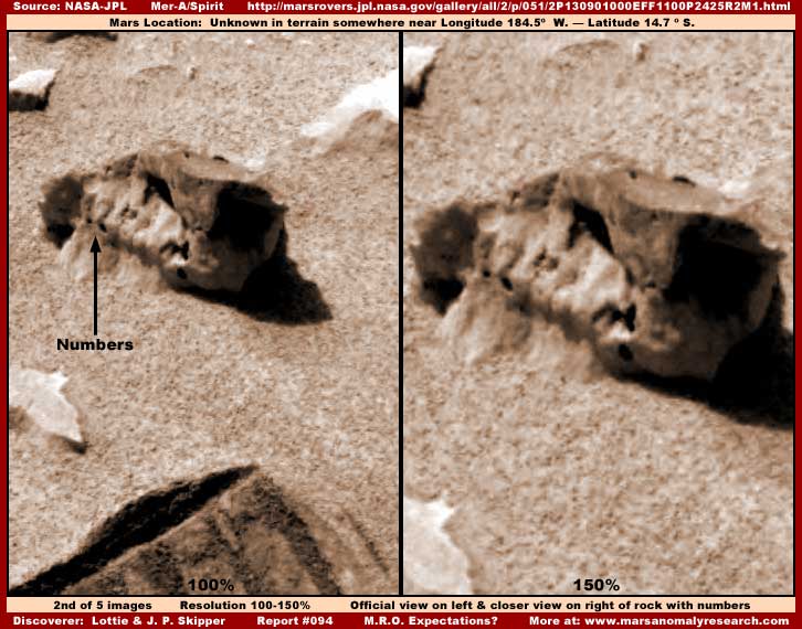
The above second split screen image shows a rock with what appears to be the number "12" or at least the number "1" on it on the left with a closer comparison view of same on the right. Note that two hash marks to the immediate upper right of the number "12" look very much like "inch" designation marks. Note also that a portion of the same rover tread track seen in the above first split screen image on the right can be seen at the bottom of the left image here giving you an idea of the relative placement of the tread imprint and rock number evidence in relation to each other in the overall image.
In my opinion, the ground surface texture all around the rock is mostly artificially created modifying the visuals of the true ground surface giving it that very even pattern look. This type of image tampering has spilled over into the tread track altering its surface appearance as well as discussed above. The effect on the tread track is subtle and adapts to the imprint preserving some of the basic truth but also substantially altering it. It is sort of like a few current advertisements on TV showing a real person with a solarizing effect over the face area causing it to resemble a artificial animated face. That way it looks like excellent artificial animation because the person's real basic underlying expressions are visually preserved.
Even so, I suspect no one could recognize the real individual behind these surface effects and that's the effectiveness of this type of planetary data image tampering in its goal of obscuring full information truth. It compromises all of the true finer surface detail while preserving background coarse visual basic information just like the face treatment mentioned above. The tread track just looks a little aged and human behavior is such that we just don't look any closer with a deeper questioning eye.
Likewise, in the above second image, what appears to be a rock with the number "12" on it is in my opinion an object whose visual effect is entirely created by various smudge image tampering direct applications completely hiding whatever was real there. The number "12" is probably only a chance alignment of the image tampering applications out of the hundreds of thousands or millions of such applications in the rover imaging full of such detail obfuscation.
In other words, you have image tampering object specific direct applications like this designed to hide something specific and this is backed by general image general applications like this false soil grain effect mapping to objects and terrain designed to degrade general resolution and subtly alter detail while still preserving the basic outline information. The whole of this is further compromised by offering for public consumption only severely compressed and degraded resolution .JPEG imaging as though it were actually the true (far higher resolution) science data that now conveniently cannot be examined closely enough to determine otherwise.
For those who have trouble with this concept, try taking a much closer look at that "rock" in the above second image with the number on it. Human behavior assumes that this is the visuals of a rock and we see what we expect to see. It is how we are tricked into accepting what isn't real. However, there actually isn't any real rock geological detail there at all, only a collection of featureless different color smudge image tampering applications in a confined area that sort of resemble a rock and its shadow. Welcome to the wonderful highly flexible world of digital imaging.
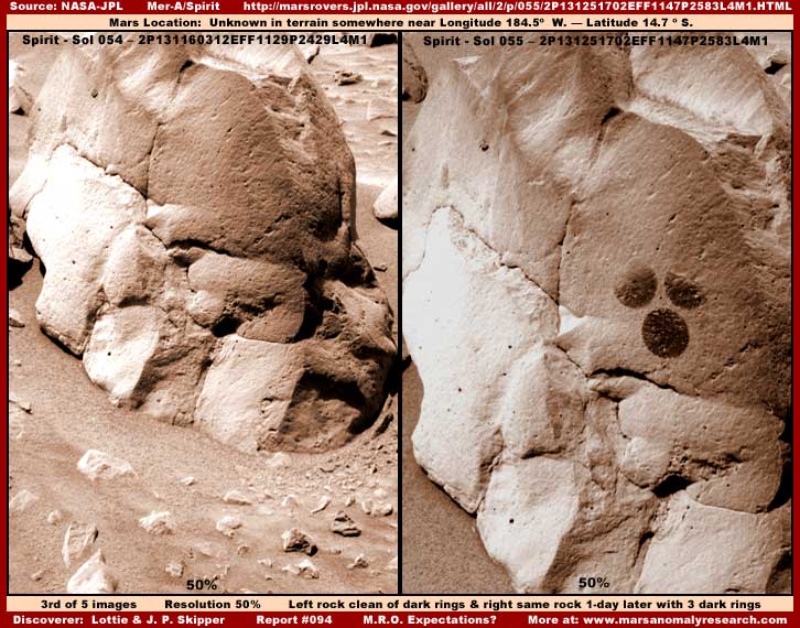
Above is another example of how truth is compromised in the rover imaging. The above third split image demonstrates a rock group in the left image taken on Sol 054 that has no artificial dark marks on it and in a different image taken one day later on Sol 055 the same rock in the right image now has three dark circular identical size marks on it in a very precise triangular configuration. Since these three dark round marks are about the same size as the drill head on the rover articulating arm, it is natural to assume that this is somehow what caused them. However, these aren't drill depressions but appear to be round marks imprinted on the surface of the rock. The question is made by what"
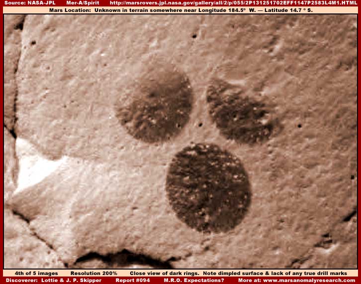
The above fourth image closer view of the three dark round marks clearly shows them to be marks on the surface of the rock and definitely not drill depressions. Note that the bottom mark is full and round with sharply defined perimeter edges while the other two are faded out in their upper areas. Note how equally sized and placed they are one relative to the others in this triangular configuration. This precise alignment alone shouts "anomalous."
Even if the official position is that the marks were made by one of the rover's articulating arm instruments, the question then becomes a pronounced how? What instrument, if not the drill? Even if it was possible, how could this very precise triangular configuration alignment be achieved via long distance from Earth via remote robotic manipulation navigating on uneven surface? To what purpose?
Further, note the rough blotchy surface texture of the dark round marks in the above fourth image. In my opinion, this appears to be many blotches of small scale smudge image tampering applications conforming to, plastering to, and possibly obscuring something original there. However, although not as easily seen, the same is true of the lighter color rock surface. I suspect this is another example of the same kind of image tampering in the above first image on the right of the rover's tread tracks giving them the old grainy appearance and appearing to have collapsed debris in the darker tread indentations. Because the tampering applications map to the rock surface and faithfully preserve the different natural colors of light and dark background outlines, that's why we continue to see these dark mark outlines even after the tampering applications.
Did something or someone else make these three marks over the period from Sol 054 to Sol 055? If the Rover didn't make these marks, then what did within this roughly 24 hour period? Certainly it represents active artificiality and obviously is nothing natural.
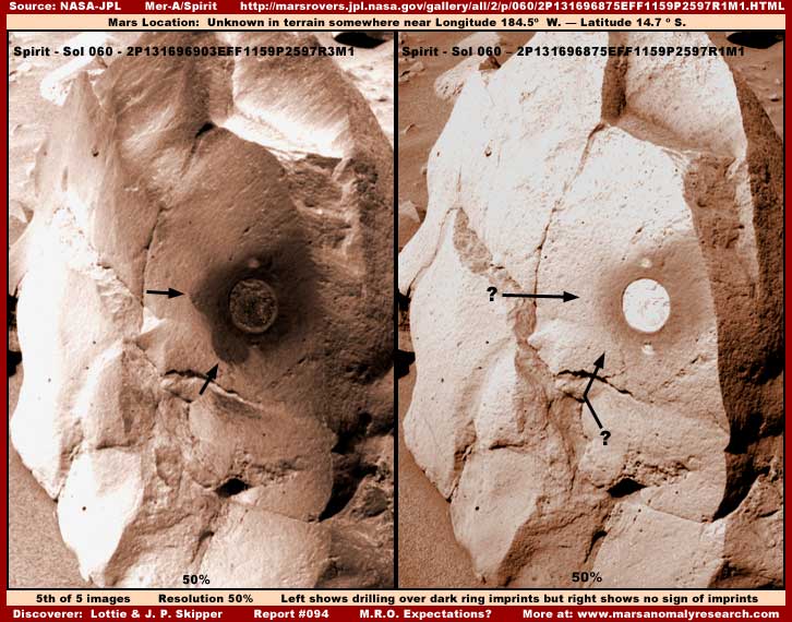
Just in case one might still be inclined to think that the three dark round marks are drill depressions somehow corrupted by image processing problems, the above fifth split screen image taken five days later on Sol 060 demonstrates even more conflicting evidence. As you can see in the image on the left, here is what the true drill depression pattern and size looks like complete with its two outrigger housing marks. There is no mistaking it. Further, carefully note that the drilling was made in the same place as the three dark round marks and the edge of two of those marks are still partially visible on the left with my two arrows pointing them out.
Also significant here, note the diffuse dark stain area outside the drilling hole being especially pronounced on the right side as drilling dust blew off more in that direction. This is typical of the drill hole staining the rock surrounding the drill hole. Now go back up to images number two and three in this report and note that clearly no such staining is present with the dark round mark evidence confirming at the very least that these marks were not made by the rover drill.
But that's not quite all, note the above split screen image on the right. Although this image is taken in very light contrast washing out detail, the drill hole is clearly still seen as is the drill dust staining field around it. However, note that in this image taken on the same Sol 60 day as the darker image on the left, the dark round marks are now completely gone. Further, no amount of darkening or other manipulation of this image by me will bring out even the slightest sign of those dark marks.
All of this conflicting evidence brings into question whether the dark round marks on this rock group are real or not. Could they not be real at all and be artificial creations of the image tampering from the start? If so, to what purpose? Further, if so, why drill after all at this specific spot? Could the drilling and the last right image be an attempt to sanitized the dark spot evidence or what ever it may have covered from view? Could the above right image be attempting the same thing through subsequent image processing and those doing this are just too careless and/or time constrained to adequately clean up all these inconsistencies?
The point I'm trying to make here is that, if disturbing and conflicting evidence like this on objects only a few feet away from rover cameras touted to have some of the best digital imaging Earth has at its disposal can be obfuscated (now you see it & now you don't) through the advancement of computer and software technology on the processing end of the data down stream, one must realistically have very reserved expectations as to what truth will be publicly revealed by the new MRO camera data when it starts sending its data. Just remember that imaging technology for good or bad advances on all fronts, not just in camera resolution that someone may want to limit our attention to. Maybe they do finally intend to start revealing something truthful about Mars with the advent of the MRO data but I wouldn't count on it.
Worse, this unfortunate reality is compounded even more by the apparently naive academic and science leadership's determined avoidance of taking any of this visual evidence being compromised in this way into consideration when they inspect this planetary exploration data. As long as they and we in the general public accept such conflicting evidence as normal, truthful and without question, I'm afraid that ignorance will rule supreme and no telling what kind of issues are building up behind the scenes just out of our perception and without our consideration or input as a few in secrecy continue to manipulate the many.
I hate to ramp up the rhetoric here because it's just not my way. Yet, I believe that we must question whether or not we are all a bunch of cattle going to blindly following someone's lead in an unknown direction to an unknown end, abdicating responsibility in that way, or are we a independent thinking species capable of rising above our everyday lives and being responsible for and involved in our wider planetary destiny? Each of you must decide for yourself and within yourself.
CREDIT
Much of the image evidence in this report was first brought to my attention by a viewer named Lottie asking me questions as to what I thought was in them. While she may not have understood all the implications of this evidence, at least as I've presented it here, her focussing my attention on these images was instrumental in producing this report and whatever insight merit it may have.
DOCUMENTATION
http://marsrovers.jpl.nasa.gov/gallery/all/2/p/586/2P178389601EDNAE03P2276L4M1.HTML: This link takes you to the Spirit Sol 586 Panoramic camera official science data image from which the evidence in my first and second images in this report were drawn.
http://marsrovers.jpl.nasa.gov/gallery/all/2/p/054/2P131160312EFF1129P2429L4M1.HTML: This link takes you to the Spirit Sol 054 Panoramic camera official science data image from which the evidence in the left side of my third image in this report is drawn from.
http://marsrovers.jpl.nasa.gov/gallery/all/2/p/055/2P131251702EFF1147P2583L4M1.HTML: This link takes you to the Spirit Sol 055 Panoramic camera official science data image from which the evidence in the third right split screen and fourth image in this report is drawn.
http://marsrovers.jpl.nasa.gov/gallery/all/2/p/060/2P131696903EFF1159P2597R3M1.HTML: This link takes you to the Spirit Sol 060 Panoramic camera official science data image from which the evidence in the left split screen of my fifth image in this report is drawn.
http://marsrovers.jpl.nasa.gov/gallery/all/2/p/060/2P131696875EFF1159P2597R1M1.HTML: This link takes you to the Spirit Sol 060 Panoramic camera official science data image from which the evidence in the right split screen of my fifth image in this report is drawn.
, Investigator
![]()