
MARS SHORELINE & LIFE EVIDENCE
Report #082
January 30, 2005
The information in this report is about a Mars South Polar Cap shoreline and the evidence of life at such shorelines. This report is also a supplement to my 11/21/04 report #077 titled "Mars South Pole Flood Waters" and my 12/15/04 report #079 titled "Mars South Polar Ring Anomaly" and a continuation of their evidence of water and life at the edges of the South Polar Cap. If you are not familiar with content of these two reports, suggest that you review them for additional insight into the evidence presented here.
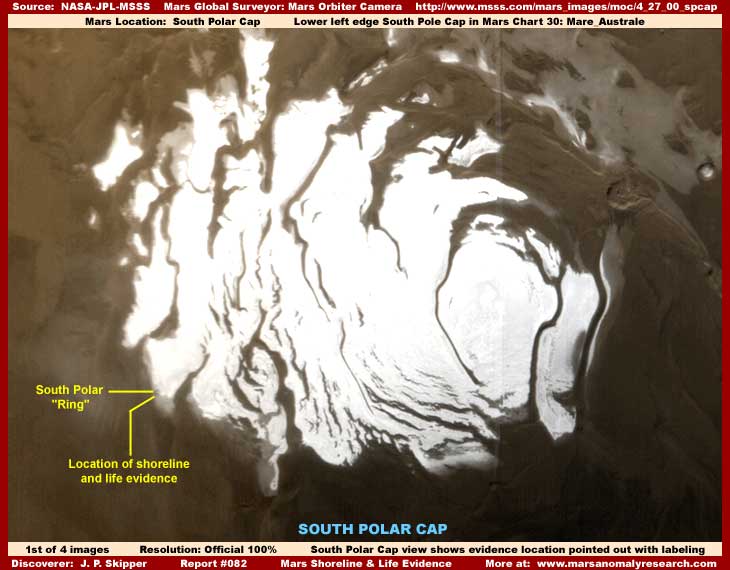
As you can see in the above first global image, the evidence in this report is at the edge of the South Polar Cap and very near the South Polar anomalous "Ring" pointed out with the yellow labeling and right at the boundary between darker color visual evidence where seasonal water stands at certain times of the year as indicated in report #077 and the very much lighter color terrain form that is a part of the South Polar Cap. The faintly seen "Ring" anomaly is also pointed out as a location reference point indicating how close the evidence here is to it.
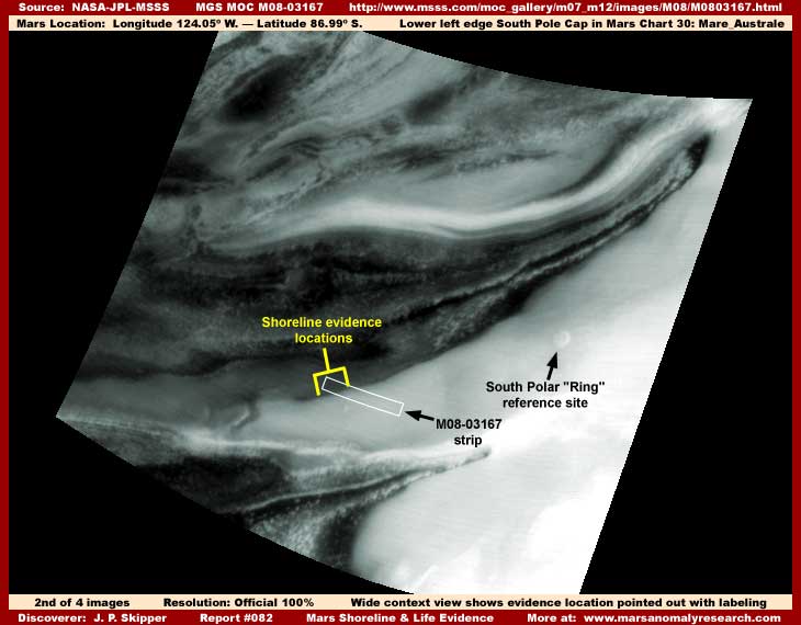
Now the above second image provides a closer but still distant wide field of view of the general site where this evidence is located as pointed out by the yellow labeling. Over to the right of that is the South Polar "Ring" anomaly reported on in report #079. This image was taken on 10/14/1999 earlier in the MGS mission and during the seasonal dryer cycle of water presence at this edge of the South Polar Cap. For more information and insight on the presence of seasonal water flood cycles at the Mars South Polar Region, please refer to my report #077.
Now, in my opinion, this above second image is also one heavily obfuscated by image tampering. All of the light color areas are basically solid carpeting image tampering. In fact, although I suspect the official explanation would be that this is CO2 snow, it is not and everything you see in this image, whether dark or lighter color, with that soft fluffy smoky featureless look is image tampering. Note how this also covers up the anomalous "ring" feature. If the tampering application had not"mapped" to the round ring feature in a circular motion and into a depression, we wouldn't be seeing that either.
The point is that even though most everything real on the open terrain is covered up here, the image still serves as a decent reference image demonstrating the location of the shoreline evidence reported on here. I'm going to this much trouble wasting two images on location because this evidence, despite its apparent simplicity, is a important and very significant discovery as the future and posterity will no doubt eventually confirm. So, now that location and its reasoning is pinned down, let's get on with the evidence itself.
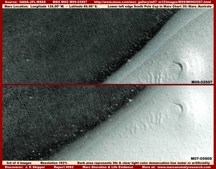
I've used the above M09-02507 and M07-05909 official science data images in an over an under split screen presentation to give a good A-B comparison of the same type of evidence at or very close to official resolution in two different images. Note that these are just representative sample images and there are a number of other images of spots like this all up and down this particular shoreline. A few of these additional official science data image strips are listed near the end of this report for additional reference. However, just like these two, even though these images are all supposed to be closer narrow-angle imaging, they are really more distant than readily apparent and therefore of poorer resolution that will not allow any large degree of zooming on the evidence before pixelation becomes a factor. Even so, this is telling evidence, as you may begin to understand.
I've used these particular two images as representative samples of others because the sort of half moon looking terrain feature on the right is common to both and serves as a reference point. All of the dark area you see on the left is thick, dense, heavily packed, tall, flourishing LIFE. It appears to be biological life of some kind looking very much like vegetation or some giant mold form. However, it may just as well be colony animal organisms that mimic the look of plants to, as I have reported on before. In other images of this area and those further out in the dark areas taken at different times of the year, this densely packed solid carpeting mass starts breaking up demonstrating that it is a dynamic changing seasonal presence of some kind subject to change and not to be confused with fixed terrain geology.
As you can see, the dark pattern evidence stops abruptly and sharply in a clearly seen demarcation line. That is itself a telling point. However, much more important is just beyond that dark life demarcation line is a second clear and transparent but abrupt and sharp demarcation line. It demonstrates conclusively that something very clear extends over the dark pattern life evidence and comes to an end at this point on the terrain providing us with this second visual shore demarcation line.
You will also notice that the white specks (remember these are distantly seen and the size of each speck would be much greater than they visually appear here in this distant imaging) clearly seen concentrated much more thickly all along this boundary line both on/in the dark pattern life evidence as well as in the clear space between the dark pattern demarcation line and the clear transparent space demarcation line. However, please also note that in no case do these white specks extend to the right beyond the clear demarcation line and onto the open terrain. That to is significant.
It is significant because it clearly demonstrates that the white specks are contained within and/or under something that is very clear with no reflective surface, at least none that can be seen here. In other words, there is something over the dark pattern life evidence that cannot be seen except for the clear presence of its shoreline termination demarcation line. What that something may be is of course the jackpot question.
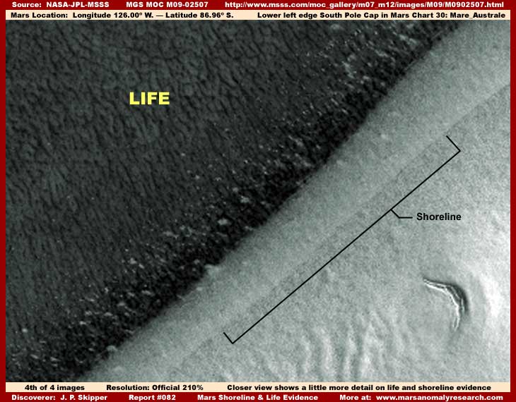
The above fourth image provides a closer view of the dark pattern densely packed life and the dark pattern and clear field demarcation lines evidence. I am satisfied that we are looking a super dense biological life evidence in the dark area. My only question is whether we are looking at true vegetation or mold form or a colony life form that mimics the visual appearance of vegetation?
The dark pattern life evidence, although astounding, is reasonably familiar to me. But, the real question for me here is what the clear field demarcation line truly represents? The first reaction of course is to suspect that this is very clear and very still surface water and especially in light of my report #077 as to the presence of a lot of seasonal water at the edges of the South Polar Cap right where this evidence is located. However, these images were taken during the dryer period of the seasonal water flooding cycle with less water theoretically present and all of the various images of this evidence indicate a too clear and too perfectly still surface regardless of the seasonal cycle. So, I am suspicious that this clear very sharp demarcation line may not be water, or at least not a surface water only type of shoreline.
Yet, there is definitely something very clear there over this field of dark pattern life evidence. Could this be a stable gelatin like substance rather than water that has a measure of stiffness and body to it? Some substance perhaps produced in massive quantity by the dark pattern life to protect itself and help it flourish during the dryer times? Yet, one would think that such a substance would also have a surface that is also light reflective to some extent? Yet, this isn't the case.
When pondering this, I am also reminded that Mars demonstrates the presence of extensive civilizations with command of some very advanced technology beyond our own. Remember to that nearby is the "Ring" anomaly with its very suggestive civilization evidence. Could this evidence we are looking at here be hydroponics gardens under a very clear protective cover that may be of substance but also a force field explaining the lack of light reflectivity on the surface? Could such technology also be present at the "Ring" site also providing a protective non reflective surface cover there? The edge of the Ring at that site cannot be seen because of all the blur image tampering that covers the outer perimeter of the Ring feature. Could something like this edge of some barrier we see here be what the tampering there at the Ring is hiding?
Is this a non reflective protective covering field over high tech agricultural hydroponics mold farming supporting the Ring community and what ever other civilization evidence is around it that needed to be covered up by the image tampering applications in the above second image in this report? If so, is such a protective barrier meant to keep water out during high water conditions or keep it in during low water conditions? Could it be both? Perhaps protecting crops underwater during flood stage and then retaining water within its interior during dryer times?
This report necessarily has to be brief on this particular type of discovery because to explore this evidence in sufficient detail would require volumes of text and a great many images that I do not have time for here. Also exploring the evidence in that kind of detail is not practical here in this type of Web site reporting where I am trying to just wake people up to anomalous evidence like this. If the scientists would ever break out of their self made psychological prison one day and look around a smell the evidence objectively, perhaps they can eventually pick up the ball and contribute to developing this discovery information in more detail?
As you can see, this kind of evidence brings up a lot of unresolved questions where one can easily get tripped up in the details that this poor quality imaging as released to us cannot supply adequate answers for. Some of the possible explanations explored here may be closer or further from the truth, yet one thing I am satisfied of is that the dark pattern evidence represents flourishing biological life of some kind as opposed to geology and the clear field demarcation line either represents liquid or semi-liquid of some kind and/or high technology, all of which evidence points in a completely different direction than that promoted by the ever present official mantra of Mars being a super dry, frozen, dead world hostile to life. So please wake up scientists and examine evidence like this objectively! It is after all your job, not mine! At least is is put it in front of you.
Meanwhile, with each one of these type of new independent discoveries revealed, Mars comes more and more out of the official darkness and into the light as a world very much alive and teaming with life, including intelligent advanced life. My only hope is that you viewers examine all the accumulating official as well as anomalous evidence like this and decide for yourself rather than let your leadership decide for you. Unfortunately, full truth is very conspicuous by its absence at official level and this failure of our leadership necessarily leaves us to our own ends for the answers we seek with respect to the full extent of the real environment we live in.
ADDITIONAL EVIDENCE
The links to the additional official science data image strips below all provide additional views of this same type of shoreline and life evidence elsewhere along this particular shore. They provide different views reinforcing the representative sample images seen here and the observational concepts presented in this report. But, except for variations in the dark pattern evidence reinforcing it as life and white spot evidence, they do not really provide any new additional information or insight, just reinforcing more of the same as presented here. There are also other similar image strips but I am not going to list them all here. The ones listed below should be sufficient to convey the insight that this discovery evidence of life and the presence of surface liquid and/or artificiality is significant all along the shore in this general area well beyond that demonstrated by the evidence imaging in this report.
M08-06597
M09-03939
M08-07262
M08-00325
M08-02736
E07-01928
E07-01778
DOCUMENTATION
http://www.msss.com/mars_images/moc/4_27_00_spcap: This link accesses the official MOC global image of the South Polar Cap that is the source of my first image in this report.
http://www.msss.com/moc_gallery/m07_m12/images/M08/M0803167.html: This link accesses the official MOC M08-03167 wide-angle image (on the right) that is the source of my second image in this report.
http://www.msss.com/moc_gallery/m07_m12/images/M09/M0902507.html: This link accesses the official MOC M09-02507 narrow-angle image that is the source of my third top split-screen image and fourth image in this report.
http://www.msss.com/moc_gallery/m07_m12/images/M07/M0705909.html: This link accesses the official science data MOC M07-05909 narrow-angle image that is the source of my third bottom split-screen image in this report.
, Investigator
![]()