
MORE MOON BANDING
Report #071
August 8, 2004 (documentation replaced 2/16/10)
In my opinion, this new evidence of the
bands on the Moon's surface is too important in its implications to leave
it to just my previous #070 report titled "Moon
Banding Evidence." So, I'm including this second report with yet
more of this type of evidence from different Moon locations to provide more
exposure in emphasizing this type of incredible evidence, its significance,
and to demonstrate that the previous report #070 banding evidence limited
sampling isn't some kind of fluke or aberration in the Moon satellite imaging.
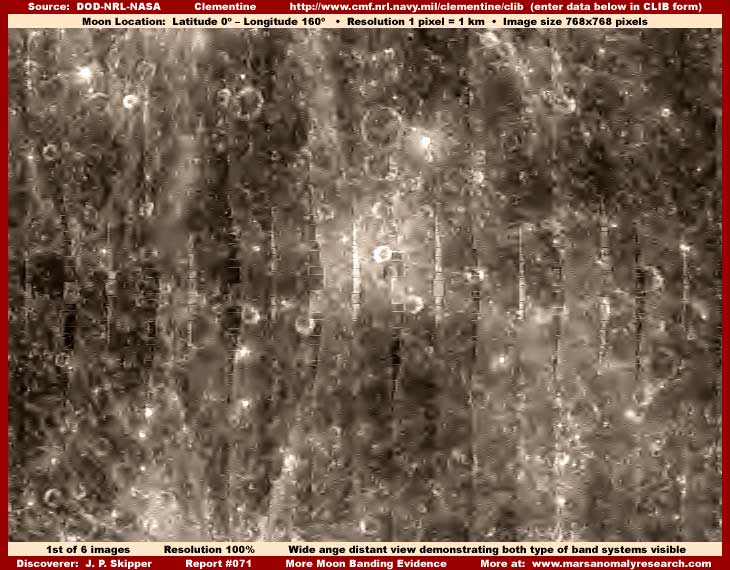
At their stated resolution of 1-pixel = 1-km, the above first image is the
official closest view. It is difficult to tell because of all the obscuring
tampering covering up all size frames of reference natural geology but this
is still a relatively distant view provided in the military's Clementine official
science data. Because the official imaging is out of focus and a bit fuzzy,
the only thing I've done in these images is to clarify the view with some
mild color and sharpening. In the normal fairly poor fuzzy official view,
these many vertical lines might well be confused (no doubt by intent) with
the Clementine camera orbital path narrow strip imaging junction (joining)
lines where the craft moved over laterally 2.5 degrees on each subsequent
orbital pass.
As I've stated in my previous #070 report, I suspect one of the purposes of
this choice of orbital path was to match the orientation of the true ground
based band evidence they already knew was there. Why?
Because they knew that, while any automated computerized image tampering obfuscation
tactics they would use would be largely effective, they would not be perfect
and the overall band patterns would still be visible printing through the
mapping tampering applications as the map aspect of the tampering software
maps and conforms to their elevated shapes and an explanation would have to
be ready and waiting for that. It is anticipated that their explanation would
be that these are digital camera imaging artifact lines where the many digital
individual images are joined together in a mosaic to form a long south to
north pole oriented strip and these long strips would then be joined together
and these "lines" would be the unfortunate result.
However, with clarity enhancement to partially defeat the official fuzzy quality
as part of the obfuscation tactic of the official imaging as released, you
can clearly see that this is not really the case. Once there is a better less
occluded view as seen here, you can clearly see the individual differences
between the bands. Also, note that it is only every other band that is solid
appearing with a light reflective color while every other band in between
is a darker color with an open network appearance of short parallel straight
and right angle lines. It is quite obvious that these close and uniformly
spaced bands are ground based phenomena and not even remotely to be confused
with digital imaging artifacts.
As further evidence of this, look very closely at each band in the above first
image. Note that each band, whether the lighter color solid or the darker
color open network appearing type, is completely unique with its own special
pattern and characteristics and that this unique pattern is definitely not
repeated in nearby bands. This characteristic of the individuality of each
band alone precludes imaging artifacts and their natural repeating uniformity
as being a factor.
Also, note how the otherwise straight darker open network type bands also
swell in an arc deflecting to the right just a little in sections of their
length deflecting well out of the camera's straight orbital flight path. Digital
imaging junction lines would be expected to be much more uniformly straight
and not like this at all.
As ground based phenomena, is this lateral deflection to the side a function
of terrain based geology such as a change in height of the terrain? The answer
is no. This is in reality an illusion created by the image tampering applications
placement on these bands creating wider appearing spots down their length.
As confirmation of the true straight quality of all of the bands, note that
the lighter color every other band types right beside them are still arrow
straight down their length denying any ground irregularities as being a factor.
Remember to that, although the individual bands appear narrow here in this
official very distant view, they are in reality very wide and thick. The official
resolution statistics say that the official imaging used here is 1-pixel equals
1-kilometer. If true, that makes each band very wide/thick indeed at as much
as several kilometers across. That's really huge! Obviously, that simple fact
alone would preclude digital imaging artifacts as a factor where imaging splice
lines would be expected to be so thin as to be nearly invisible.
In fact, this can be confirmed by examination of the joining of the Clementine
images near the either of the polar regions where more imaging angle is involved
and therefore more distortion reveals the repeated presence of the true imaging
splice lines as very faint thin lines just as one might expect them to be
and much further apart than these bands. The last image in this report demonstrates
this evidence to confirm.
In such digital satellite imaging, splice lines that are actually visible
and identifiable at the official resolution are sometimes a function of imaging
poor terrain offset edge matching or much more often dissimilar false terrain
textures due to differences in tampering applications than anything else.
Otherwise, they are usually not visible at all except under very substantial
magnification. The telling point is these broad thick bands bear not the slightest
resemblance to imaging splice lines.
Finally, there is the abundant and great variety of imaging tampering applications
and their impact to consider. They are so thick and universally applied in
this Clementine imaging that they create a sea of meaningless jumble of false
illusion detail out of the terrain so that little actual Moon surface detail
is visible at all. Except for some band outline print through, the thick bands
are mostly covered over and obscured by this tampering jumble. Only short
sections of the bands total length are visible while the great bulk of each
band length is covered over. The image tampering applications also tends to
give the bands a false illusion of tapering at the visible ends that isn't
real.
Also, very close examination reveals that the bands are for the most part
covered up UNDER these applications with only their vague outlines then printing
through from underneath the mapping applications. The fact that they are covered
up by and under this blanket of tampering applications implies that the bands
are real ground based phenomena detail and are not themselves digitally created
illusions. It would be hard to imagine the point in going to all the trouble
of artificially creating so many bands, including even their unique individual
appearance patterns, and then turning around and covering up most of that
tampering work with more tampering work with only a little bit showing through
here and there as seen here in the universal tampering fields.
I suspect that we see these small portions of the bands left out of the tampering
only because the automated map tampering software is programmed, probably
based on percentages of coverage, to leave some true but minor amount of terrain
detail out within the tampering field on the theory that there will be too
little of the total anomalous evidence left out to be recognizable. A little
true detail left out breaks up the otherwise featureless tampering field so
that it doesn't draw as much attention to itself. That strategy probably works
reasonably okay on small to larger finite patches of anomalous evidence but
doesn't work nearly as well on the same kind evidence that covers a broad
massive area as is the case here.
In such a scenario, the only thing available to leave out is critical identifiable
material. For example, here the tampering is effective because it has essentially
destroyed almost all geometric evidence including that on the bands themselves,
especially the darker color open network looking bands. But, the darker mapping
applications there still left some lighter color edges out that are forming
the straight lines that you see. Further, the overall pattern is still too
pronounced and still too much in evidence. Fortunately for you and I, this
demonstrates that no technological solution is ever perfect, particular in
the face of the massive scale of evidence to be obscured and so compromise
is the name of the game.
But, this "... in the face of massive scale of evidence ..." concept
brings up other considerations. Remember, the image tampering is evidence
to and it is on a massive scale literally obliterating most of the visuals
of the entire Moon surface. Does the implications of that escape you?
Likewise, if the image tampering is to be effective enough in keeping secrets,
it is must be due in part to the technology and in part with its roots in
our human psychology. Remember, this evidence you are seeing here has been
around since 1994 for many years and seen by a great many scientists and other
researchers but has never to my knowledge been seriously questioned or this
aspect of the evidence brought forward. It is only now beginning to come into
some conscious awareness. One has to ask why?
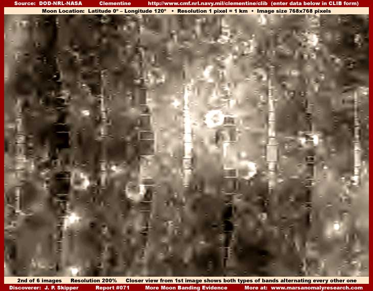
The above second image shows a portion
of the same scene in the first image but with a closer 200% zoom view. The
200% zoom factor is about all we can get out of the official Clementine imaging
before too much blur and imaging artifacts begin to be a visual factor.
As you can clearly see and as has been pointing out in previous reporting,
smooth smudge image tampering covers most of this scene destroying most of
the band's visuals with only parts of the banding seen. Further, even on most
of what little of the rest can be seen, the tampering fields invade it covering
most everything. Even so, although the tampering has mapped to this evidence
and covered the center area volumes of each rectangular object or structure,
it has left the lighter color edges out demonstrating the many right angle
geometric pattern characteristics of this evidence.
It is these many obvious straight and right angle rectangular patterns left
out of the tampering applications that shouts obvious artificiality. It is
so incredibly obvious and revealing to the point that there can be no mistake
about it. There is not the slightest chance that rigid uniformly repeating
hard evidential patterns like this can be confused with Moon natural terrain
topography. Likewise, there is not the slightest chance that this hard visual
evidence could be confused with digital imaging artifacts of any kind.
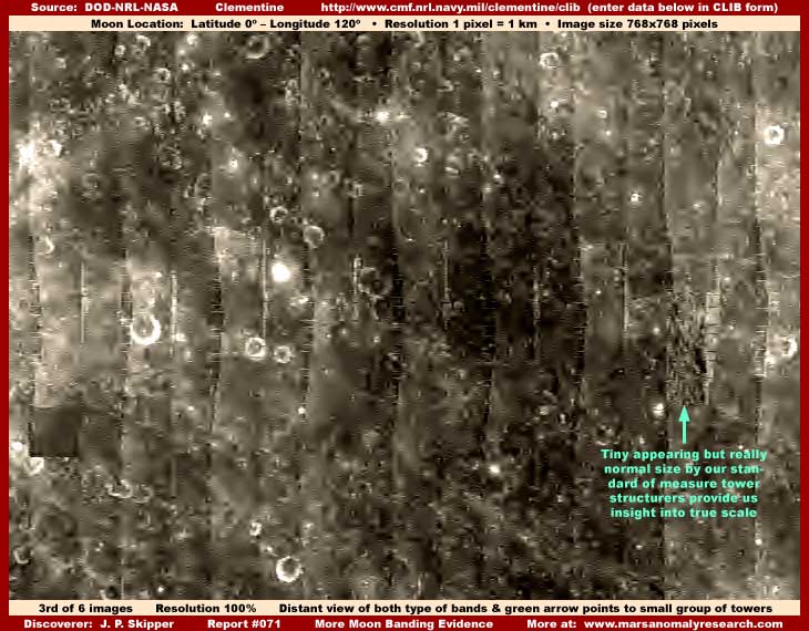
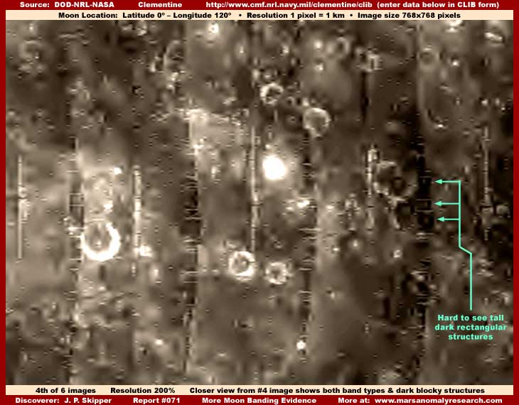
The next four images just show different band locations on the Moon's surface.
First there is the official distant view and then with a 200% closer view
of the same scene repeating the presentation style of the two images above.
Since they represent just more evidence of the same phenomena, I'll just let
the images speak for themselves and add my two cents onto the end,
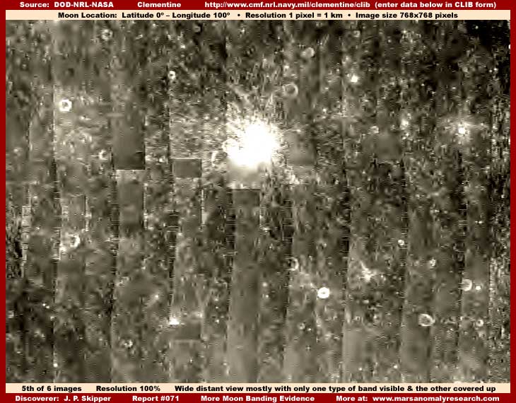
If you were looking at these scenes in the official science data imaging such as the above fifth image and only with its more fuzzy view unlike the sharpened one above, it is understandable to some extent to see how many researching this evidence and accepting official information on it at face value might assume that all these many vertical south to north lines are the junction lines joining digital image strips in a mosaic greater whole, just as I'm sure was the intended misdirection. If one doesn't look very close, this illusion is more intact in this official resolution view but then falls apart in the closer views.
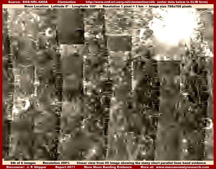
As you can see in the above sixth image, when one looks closer, the illusion does start falling apart and a different reality begins to assert itself. One where it is easier to see the thickly applied universal featureless smudge tampering in the spaces between the bands and how this crosses over onto the bands. If it were not for the software's mistake that the tampering applications on the band structures only map to the edge of each structure leaving a very thin more light reflective strip at the edge of each structure out forming what appears to be a line, the illusion goal might be complete.
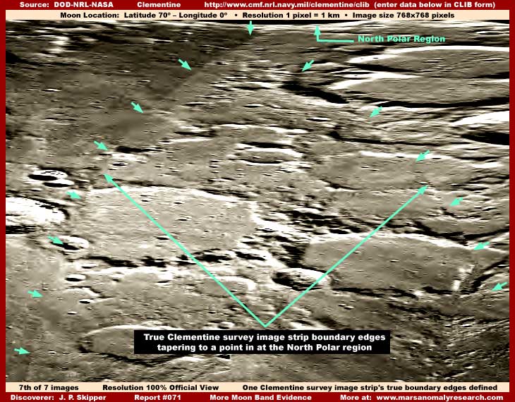
Just in case anyone may require proof of
what the Clementine true image strip boundary edges actually look like, I've
included the above seventh image even though it is going to bog down the loading
of this report on dial-up connections. Remember, this is the exact same resolution
as in my first, third, and fifth images above drawn from the same science
data and directly comparable to each other.
Please note the very fine image junction lines as pointed out with my short
green arrows above as compared to the thick band lines with their highly individualistic
characteristics seen elsewhere in this report. Please also take special note
of the total broad width of this image and the fact that you could place many
adjacent band lines within this one strip. Obviously, the true Clementine
survey image strip boundary lines have nothing what so ever to do with the
band lines.
The fact is that we are seeing these fine image junction lines for several
reasons. One minor reason is that this location at Latitude 70º N. and
0º Longitude is very near the transition point where the satellite begins
to mover further away from the Moon's surface over the in this case the North
Polar region, the camera swath starts converging to a point in the North Polar
region typical of the Clementine imaging, and distortion of the surface begins
to play a bit of a role. Second and also relatively minor, there is some slight
mismatching of the terrain at the edges.
However, the most dominant reason by far is the mismatch in tampering applications
between the strips involved. For example, note that the tampering applications
in the upper left of the scene are darker to the left side of the line than
on the right side. I might point out that this also demonstrates the presence
of the tampering applications to.
If an original official image view is out of focus and fuzzy, as is the case
in the official imaging, it is reasonable to expect an automatic desire response
on the part of imaging experts right away to correct this. After all, trained
scientists dealing with satellite imaging are all trained and knowledgeable
enough to bring this evidence into clearer focus in a graphics program just
as I have done here. Once this is done, even in the more distant official
resolution imaging, the multitude of short arrow straight geometric lines,
often in close parallel and at right angle counter to the camera orbital path,
are distinctly visible just as you can clearly see here in this report's first,
third and fifth images.
If we can see it so readily, then clearly they should be able to see it to.
One would think that such initial insight alone offers and even forces a real
leap forward in perception of evidence at the very least being questionable
and at the most out right suggesting artificiality. That initial perception
would logically fuel excitement and then the compelling need to investigate
closer revealing more and more anomalous information just as you seen here.
The very basic 200% closer zoom sharper imaging you see here in my second,
fourth and sixth images, is hard evidence that logically just reinforces the
perception of artificiality even more and not an impression that there is
nothing worthy of closer investigation. So what is going on here with these
people?
Likewise, look at my first six images here carefully in their whole context.
Note that there is hardly any visual aspect within these images that even
remotely resembles natural terrain geology on the Moon or any planetary body
for that matter. That's because most all of the detail here, other than parts
of some of the band lines, is a variety of image tampering applications applied
at different resolution levels and in multiple layers creating false artificial
digital detail. The result is a mixed jumble of little real at all. There
is a lot of detail but almost none of it is geological terrain. Please note
that even craters on the known heavily cratered Moon surface are visually
compromised and mostly hidden beneath these applications and very conspicuous
by their absence. I would call that a major clue! Yet, how can professionals
fail to see this?
That this is not perceived by others and especially our best scientists is
very strange to the point of even being absurd, highly suspicious and disturbing.
Are we witnessing some basic quirk in human behavior here where we see only
what we are conditioned to see and unable to see anything that deviates from
that conditioning? If it is conditioning, is this self induced, manipulated
from without, or some combination of both?
Why can't at least some these highly educated people just once in a while
think outside the "box" and reevaluate rather than everyone just
following everyone else in the all too well beaten seductively familiar and
comfortable paths? Certainly the building process upon previously gained OBJECTIVE
information is historically how man's knowledge base is advanced but that
also assumes sound accurate objective information input to start with which
of course is often not the case in an imperfect environment with imperfect
people. So we must always be alert to avoid inaccurate information getting
in to start with and we must always be ready and willing to objectively reevaluate
to make sure that we are really on the reality track with our information.
So you see, this isn't just a evolving and revealing story about the possible
presence of civilizations other than our own around us past and/or present
and some incredibly advanced technology, it is also a evolving and revealing
story about ourselves as a people and the choices we make and/or fail to make.
Are we just about fears and resisting truth that brings change or we also
about meeting change and destiny head on and aggressively? The choice and
responsibility is ours individually and collectively. We succeed or fail on
our own merit.
DOCUMENTATION (replaced
2/16/2010)
The military's Clementine Lunar Browser (CLIB) version
1.5 has been "retired" and the new "improved" version
2.0 data that replaces it now conveniently (for secrecy) does not contain
the discovery evidence presented here in this report and it appears that those
former discovery sites have been altered in the 2.0 data to sanitize them
away. Therefore, to facilitate verification and prove that the anomalous discoveries
were in fact in the older 1.5 science data and part of it for 16 years, the
links immediately below access the unaltered version 1.5 originals downloaded
by this researcher in 2004 and now parked on this website.
Report 1st source image from the 1.5
data
Report 2nd source image from the 1.5
data
Report 3rd source image from the 1.5
data
Report 4th source image from the 1.5 data
Since the general terrain around these discovery sites can still be identified
in the new 2.0 data despite changes, you can compare the old 1.5 versus the
new 2.0 sites and see the sanitization for yourself. Even though this may
be historically consistent with past secrecy treatment of anomalous Moon evidence,
I see this foolishness 16 years later military move targeting these anomalous
discoveries as particularly offensive, arrogant, and of very poor judgment.
Worse it demonstrates a serious disconnect with and disregard for the American
people who paid for this and who's sole property it is. However, you must
decide for yourself.
http://www.cmf.nrl.navy.mil/clementine/clib:
This link accesses the Clementine Lunar Image Browser (CLIB) version 2.0 noting
that version 1.5 data is now no longer available. There one can search the
official military Clementine science data based via either the graphical interface
or Moon latitude and longitude coordinates. When using those coordinates below
highlighted in green, just enter them in the appropriate coordinate boxes
and hit your return or enter key. Remember that coordinate numbers in the
southern hemisphere must be preceded by a minus sign.
Report 1st & 2nd images
of bands distant & closer: At the above link on the form provided
enter 0 in the Latitude box and 160
in the Longitude box and then hit your enter or return key.
Report 3rd & 4th images
of bands distant & closer: At the above link on the form provided
enter 0 in the Latitude box and 120
in the Longitude box and then hit your enter key.
Report 5th & 6th images
of bands distant & closer: At the above link on the form provided
enter 0 in the Latitude box and 100
in the Longitude box and then hit your enter key. Note this evidence is in
the southern hemisphere.
Report 7th image of the
massive blocky squared low profile structure: At the above link on
the form provided enter 70 in the Latitude
box and 0 in the Longitude box and then
hit your enter key. Note that this evidence is in the southern hemisphere.
, Investigator
![]()