
BURIED TUBE SYSTEM
Report #035
March 25, 2002
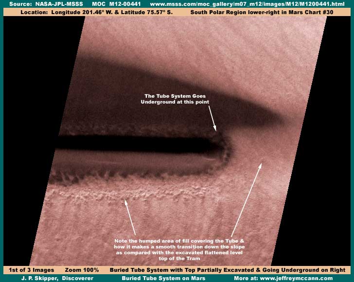
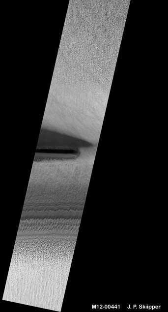
In the above first image, you're looking at the image strip sized just as appears in the official science data view but with some color added by me and some sharpening to highlight detail. What you are looking at here is nothing less than a buried huge straight as an arrow tube or tunnel system. Notice that I said buried rather than just describe it as being underground as there is a difference. To get a distant perspective on this scene, take a look at the second image as follows.
Here is what is going on in this scene. In the near ground from the bottom of the strip up, we're going up a gentle slope, over a gently rounded top and back down again into the first larger broader depression with a gentle down slope into light shadow and then back up again fairly steely to form the raised narrow tram level high ground the tube system rests in. Then just barely the otherside of the tube and the top of the tram, the second depression goes back down again fairly steeply with the raised tram/tube throwing the darker shadow in this depression. Then this second depression goes back up again in a gentle slope upward over gently rounded shoulders and off into the rocky but level terrain of the upper portion of the strip.
What you can't see here very well in my imaging without scrolling up and down in the original strip and zooming in and out is that the terrain up strip from the tube area is hard and rocky but very level. As you come down from the upper strip closer to this anomaly site, the level rocky ground seems to start being coated with some smoother substance that goes over the rim and on down into the depression, over the raised tram ground, and into and across the near broader depression. I believe that this whole double depression either side of the tube system and the tram it sits on has been artificially excavated and smoothed with loose excavated material and then this coating substance has been applied to stabilize this loose material and keep it from shifting and being a source of finer debris blown around by winds.
I believe that this tube system was originally completely buried in this loose material. At some point, someone has come along and excavated a portion of the tube/tunnel system to expose it, probably to the light. On the near and far side of the tube, the ground has been excavated away to a point lower than the tube system leaving the visible part of the structure appearing to be sitting on top of a raised tramroad on base fill material to of course support and maintain its level elevation. This excavation to expose the tube appears to be a permanent change rather than for some temporary service reason because they have gone to the trouble to stabilizing the loose material that composes this site immediately around the tube by saturating it with some liquefied and then hardened substance. Now take a look at the closer view third image as follows of just the tube system without much of the surrounding terrain.
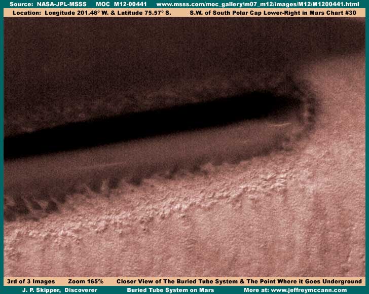
In this closer view, take note of the sand dunes up against the base of the tube's body. This indicates that finer wind blown material has still collected at the base on the tube and the dunes have been formed from this material in the air currents that the tube's exposure causes tending to act as a dam to winds. This is a process that would have occurred over time and so this is another indicator that the excavation of this tube has been like this for some time reinforcing the concept that this change to expose this section of the tube is a permanent one.
Note how the straight as an arrow tube system sits in this raised fill and then goes underground on the right under the hump of fill there. I suspect that the top of this hump of fill covering the structure at that point is the same level as the surrounding level terrain. In other words, when this structure was covered, it is effectively visually hidden. Note that where the fill covers the tube system where it goes underground, the slope of the tram simply comes up and over the tube in a smooth gentle arch or hump and then back down the far side. The pointed shadow on the right is a result of this area being the tapering end of the excavated depression as can best be seen in the first image here.
Note to the the slightly knobby but uniform coating on the fill going up the near slope and where the thickest part of it ends at the top of the slope shoulder in a fairly ragged but still distinct demarcation line as the narrow tram top levels out up to the base of the portion of the structure we can see. Note that the ultra smooth material of the structure itself is darker and occluded. This is in line with the concept that this tube or tunnel system was originally all underground where the original design may have had little need for clarity of material to transmit light. Even so, the material is still partially translucent and a few objects with faint brighter reflections can be seen within the tube rather than reflecting from its outer surface and that clearly demonstrates that this object is hollow.
If this structure is what I think it is and as I have suspicioned before with respect to other fill sites I've seen on Mars, then it is not a round tube system as we might assume. Rather, I suspect this is a giant pyramid or triangle shaped immense underground long structure and we are seeing only the pointed but rounded peaked top with earth excavated away to form a giant skylight into the much bigger and broader interior still far below ground. I call it a tube because it is long and for the lack of a better descriptive expression but it is a giant triangular tube like no tube we are familiar with on Earth. I suspect that the sloping sides of what I have called a tram here are simply fill conforming to the sloping sides of the structure underneath. The occluded quality of the material used in its construction is probably also a function of sheer thickness to stand up under the weight of the earth fill covering it.
Remember to that we are looking at this thing, not from the perspective of a airplane flying low over it as it might appear as a first impression, but from the view of a satellite camera some 230 miles distant. Therefore, this object is huge and even the individual components of that loose fill down there are really big size as well. So, we're talking serious power and technology just in the manipulation of this massive bulk of rough fill alone must less the technology to create the tube itself and put this stabilizing coating on the ground surface.
As far as I'm concerned, we are looking at the first true demonstrable evidence of extensive underground civilization evidence on Mars and this is a good indicator as to what other apparent strange smooth peaked land formations on Mars might mean. Also, at last Richard Hoagland has his underground tube system that he mistakenly keeps wanting to attribute to the Ridge Forms (as I've identified them) life form organism that forms in shallow water flowing down a slope as I've reported on a number of times.
Finally, I believe that this evidence of underground civilization is the key to understanding what is going on at another anomaly site that has been officially and humorously dubbed with the moniker "Inca City" in this MSSS science data. This bit of condescending humor labeling is of course designed to warn and deflect any serious attention away from this highly anomalous site. This is an area on Mars that is characterized by absolutely immense smooth earth fill sharp peak ridges that are straight but also form sharp right angles and include profound geometric rectangular boxes in the terrain.
Even though I ran across this other site all the way back in mid-year 2000, I have not reported on it here because I had only conjecture and no real key to help you understand or believe what you might be looking at. Now this partially visible top section of a underground installation reported on here provides evidence that this kind of long artificial construct does exist hidden underground on Mars. This one may not be visible as a hump line in the surrounding terrain when fully buried but those at "Inca City" are much larger, probably laid right out on the surface on leveled stable bedrock below, and then covered up with literally mountains of fill forming absolutely giant smooth sharp peaked triangular ridges created with fill material. So remember this report and look for a report from me next on the "Inca City" to tie this in.
DOCUMENTATION
http://www.msss.com/moc_gallery/m07_m12/images/M12/M1200441.html: This link takes you to the official MGS MOC M12-00441 narrow-angle science data strip used here in this report. There all three strips work, all have the same image orientation, but there is no companion context image to confirm the correctness of orientation. The first listed medium quality faster loading map-projected JPEG strip will work just fine for convenience in checking behind me to confirm this discovery but the second map-projected and the third not map-projected best quality but slower loading GIF strips will be better for taking quality images from if that is also your goal. Good Luck!
, Investigator
|
![]()