
A IMAGE STRIP
FULL OF MANY DOMES
Report #032
December 22, 2001
t
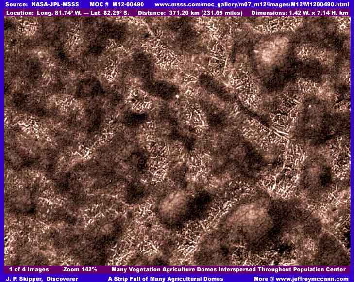
The first and second of four images here are just a representative sample of the same content that covers the entire M12-00490 image strip from side to side and top to bottom. My images here are taken almost but not quite from one side border of the strip to the other. The key features in this strip are the crosshatched lined background and the many large clump objects thickly but also fairly uniformly dispersed throughout the strip. I think it should be obvious to most that these many large raised clump objects are not natural terrain geology, not ground, and not rocks. The big question then is what is going on here in this strip and the second sample image below?
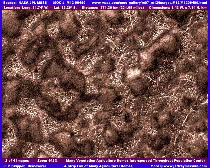
Well here again, as with most MOC imaging where content is considered not acceptable by someone at the highest levels, the crosshatch background here is at the limit of resolution making it vague and indistinct so that being really conclusive about it is just not going to happen. Still, I believe that I have an idea of what is going on here and it is very unusual.
For starters, I believe that the crosshatched lined background is dense city buildings. Rather than streets, most of the light color narrow lines are actually lines of light colored buildings mixed with more individual darker buildings that I've finally come to recognize as the way open air construction patterns often occurs on Mars for some of its occupants. This tampering technique of distancing the camera view from the background population structures just makes everything run together into a indistinct mess. It also demonstrates the high probability that those responsible for the tampering are working with images of a lot closer and better view and detail than it being released to the public or general science community
When I first saw this kind of background in other images I have not reported on dating all the way back in year 2000, there were no obvious domes as here and the vegetation was thicker and more diffuse and so I thought early on that this might be some kind of vegetation root system network exposed in occasional gaps in the vegetation. Back then I was less familiar with this distance tampering technique and didn't take it fully into consideration. But now, after seeing a fair number of these scenes and particularly this one in this type of setting, I now believe these are metropolitan centers with the buildings reduced visually to a indistinct tangled mess by the tampering technique of distancing the resolution just right to achieve this visual effect and hide the civilization evidence or at least render it too small and ambiguous to properly recognize.
Fortunately, there is not much direct application tampering here in this image strip. No doubt, as I have pointed out before in other reports, the automated tampering software did not recognize the super clear domes and there are no geometric structures inside the domes to tip it off. As I've said before, the tampering software is very good and very thorough but it is not perfect and this flaw gives us a bit of a break on the key to determining what is going on here. I say this because, if you have a good graphics software program and can look very close at all of these many raised clumps and manipulate contrast, you will see light gleaming off of clear surfaces in the air immediately above many clumps indicating the presence of crystal clear domes. This can be seen in my images here to some extent but not quite as well because I attempted to achieve a balance of clarity for both the large raised clump objects, their all important contents, and the small fine textured background detail. This balancing act unfortunately compromised the dome clear surface light reflections just a bit. I also tried different colorization tints but none of the hues I tried resulted in much better visuals so I just kept it at a basic relatively neutral color tint. A point that should not be overlooked is that there is really no ground detail here visible at all to encourage using a more natural Mars red tone, just mostly a thick carpeting of artificial structures and vegetation of unknown color tints.
Please note that the clustered tightly together objects inside each dome (contents) are always consistently visually the same from one raised clump (dome) to the next. I have seen this same visual pattern a number of times before and each and every time is was suggestive of vegetation. I believe that we are looking at agricultural domes with mature well defined vegetation inside them that is highly suggestive of densely packed tree top heads growing up against the underside of the dome and tightly filling all of the space inside each dome. What ever kind of vegetation this is, it is also growing outside the many domes but looks dark, ragged, and less well defined to the point of being blurry. At first I thought this may be tampering but I do not now believe this upon careful close examination. Further, the irregular nature of the domes tells me that the effort here has been to encapsulate preexisting groves of differing sizes which has resulted in differing shapes and sizes of domes. It is likely that the vegetation is ragged outside the domes because the environment is much harsher while the vegetation inside the protective domes is healthier, more uniformly shaped, and therefore more sharply defined.
The bottom line is that I think we are looking at a huge open air metropolitan center here with many domes protecting, preserving, and promoting healthy vegetation growth rather than the domes protecting the civilization population itself. These may be for desired esthetics such as parks here on Earth might serve and/or also serve as a attempt to provide a consistent supplemental food source which may also be why the domes are so thickly but evenly placed throughout the metroplex. Each may serve a specifically defined population (neighborhood) area. The uniform disbursement of the multitude of irregular domes can best be seen by viewing the whole M12-00490 strip as below.
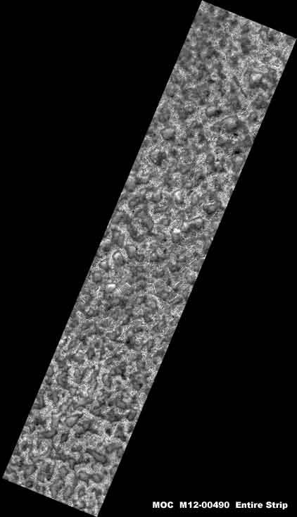
As you can see, these raised clump objects (domes) are just a tad thick and plentiful in this strip and it must be remembered that what we can see in the whole strip is only a very limited portion of what may be in the wider physical land area. Note that the statistics supplied with this strip say that the view is 1.42 km wide by 7.14 km long but I question how much faith can be placed in these measurements. If I am right and the true distancing has been manipulated, this view is apt to be much wider than stated.
For you detractors out there, I'll tell you something else that will make this seem even more impossible to you if you are one of those who insist that the officially generated but also National Security filtered temperature science data for the south polar cap region is correct. The location of this site is just a little off of the south polar cap itself where temperatures are suppose to be as cold as -184º F. below zero. So cold in fact that it is suppose to freeze carbon dioxide out of the air into a solid (CO2 freezes at –109.3° F. at seal level here on Earth) and the polar cap itself is suppose to be made up entirely of CO2 (dry ice) and not water ice according to the "informed" scientific consensus opinion that we need to remember is based on computer modeling which is in turn based on that "National Security" filtered science data.
However, the visual south polar region evidence that I have gathered so far but not yet reported on tells me that this science data is not correct by any stretch. You will see this to when I start releasing the evidence I have been holding back. It clearly flies right in the face of the "accepted" science and "consensus" opinion.
It is my position that the scholarly communities have been too trusting or shall we say insufficiently cautious in accepting key science data at face value and in not taking into consideration that all Mars science data passes through a military/intelligence filter screening process based on National Security considerations. Least you be inclined to scoff at this concept, then you need to be reminded that one of the nation's most famous super spooks has been chairing the JPL oversight committee basically in secret and JPL is the controlling force in Mars exploration and not NASA. Does that give you an idea of who is really in charge? Even many NASA and JPL insiders didn't know until this Admiral was ousted in year 2000 by a top NASA official in a internal power struggle. If you believe that he is not there for his special National Security and secrecy expertise and that he has not installed a whole network of military/intelligence types thoroughly interwoven into the space science community and screening everything, then I cry "Uncle" and give up on you.
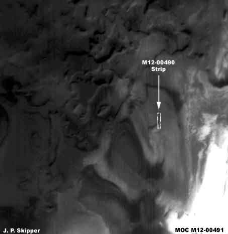
The above fourth image is the companion M12-00491 wide-angle context image for the M12-00490 narrow-angle strip. As you can see above, the location of the M12-00490 strip is shown in it. The reason that I have included this is to show you the extensive widespread dark background in which the M12-00490 strip is situated. Some or all of this dark area may be suggestive of vegetation growth. Note the depression area that the M12-00490 strip is located in and the two depression areas immediately below it. These are huge areas and they also show evidence of a dark fuzzy sweep type of blended in application tampering. If something was big enough to be seen in this very distant wide-angle shot, it must of been huge indeed. Gives one pause to think.
DOCUMENTATION
http://www.msss.com/moc_gallery/m07_m12/images/M12/M1200490.html: This evidence is drawn from NASA/JPL/MSSS's official MOC M12-00490 original strip and the companion M12-00491 wide-angle context image strip is of course found there as well. My data was extracted from the third listed, slower loading, not map-projected gif strip but all three strips work and have the correct orientation and the first listed faster loading medium quality strip will work just fine for checking behind me. However, you will need to be able to zoom in with a graphics software program to see the closer detail as represented in my images here. I have not attempted to access this material at other sites like PDS or USGS and can't say what might be available there.
, Investigator
![]()