
HIDDEN CITY ON BLUFFS
Report #028
October 12, 2001
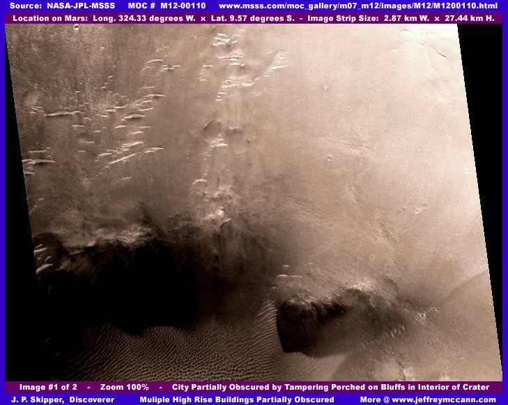
The above first image shows in its left middle and upper field what at first glance may appear to be many old upright pillar type land forms as the sunlight glares off their tops and the whole scene is enveloped in fog or mist setting. Rather a beautiful surrealistic scene isn't it. The rock formations look like similar appearing land forms out in the southwestern USA where water, wind, and temperature combine to erode the softer rock away leaving the harder inner core standing in the pillar upright column rock form. I assume that this is what this view is suppose to mimic. However, in my opinion, this interpretation is an artificially created illusion and there is actually a city of high rise buildings going up a tiered bluff system in the background here.
You should be aware that this scene is set inside a pit in the bottom of a crater and that the entire original image strip is full of many areas of fog and sweep type tampering throughout its length including the general haze you see above. There is a lot of very small size building evidence in that part of the strip immediately above my first image that spills down into the area of the above scene and terminates into this city core of larger buildings. You can recognize it if you are experienced at looking at the images and know what to look for but it is just too ambiguous for most to include here. The small ridges you see in the bottom left field partially in dark shadow of a bluff are the ridge forms associated with shallow water running down a slope as I have explained in numerous other reports. So, although I do not actually see any water in this strip, the ridge forms are a tip off that it is there somewhere, probably under some of the tampering.
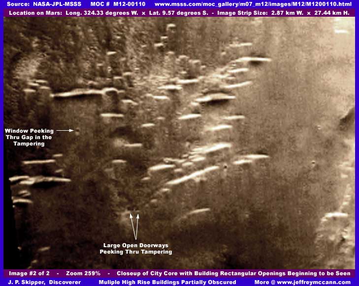
In the above second 259% zoom image which is at the limit of practical zoom resolution, I have tried to drill through the haze at the city's core with only some partial success. However, it may be enough for you to now be able to see that below the general covering haze is a city of large high rise buildings the sides and bases of which have all been covered up with a medium dark foggy smudgy tampering coating. If you will look close, you will see that the idea was to obscure the building's sides with their telltale multiple window and door openings and bases but leave just enough of the tops visible to create the natural land form pillar column look. Or, do you believe that there is a raging fire with billowing smoke or a sand storm that effects only selected parts of natural land forms in this scene? You must decide. Note that most of the right field from top to bottom that snugs up to a true land ridge (still with a few buildings on it) on the extreme right is completely obscured by this tampering. Probably there were much larger harder to obscure structures in this area.
Even though the above scene is blurry due to blowing it up so much, look very close where my labeling points and you can see some building evidence in the form of rectangular openings peeking out through little gaps in the otherwise effective tampering coating. If you will get close to your screen and look even closer, you can just make out that tiny rectangular openings can just begin to be made out in a number of the buildings through the lighter areas of tampering. This is particularly true of the area between and just to the right of my labeling. It's hard to see but there.
Please also note that the glare from the roof tops is a little exaggerated here because I put contrast on this to penetrate the general foggy haze attempting to disclose the tampering among the buildings a little better and the tiny rectangular openings in the buildings. The increased glare is the compromise price of it. By the way, I have seen it over and over again in the Mars images, narrow high rise densely packed buildings appear to be a much used building style whether in the open or inside domes. However, this may admittedly be a one sided observation simply because it is nearly impossible to make out lesser but still substantial buildings at the poor resolutions we are dealing with here in the MOC images released for public consumption. I'm satisfied that those doing the tampering have image strips with considerably better closer detail than is being released to us here and that is why the automated tampering software working with such images is so effective. Now if we could just access those high detail images and actually see what they are seeing.
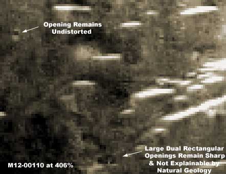
In the above third image which I decided to include at the last minute, it is blown up to 406% and heavily pixelated and distorted as each individual pixel begins to show itself. However, the point I'm trying to make here is that instead of the rectangular civilization evidence openings pointed out by my labeling in the second image here becoming just as distorted as everything else, they are still holding up very well while everything else touched by the tampering is distorted. This demonstrates that a semitransparent blur factor overlay cutting resolution was introduced with the obscuring fog tampering coating which is why the building tops are so blurred in the first two images here while this little window/hole/gap through the tampering on these larger dual rectangular openings with a sharp vertical partition dividing them demonstrates what we might have been able to see even at this extreme zoom without this tampering.
This is evidence of what the true high resolution of the original image must have been prior to receiving its quota of "adjustment" treatments. Just trying to get you to see and understand to some extent the nature of the tampering we are dealing with here in the MOC imaging. Should you be inclined to dismiss this because of its small size and isolation in the image, just remember that courts routinely accept just such tiny forensic evidence as this down to microscopic and DNA level with people's lives hanging in the balance. Evidence that reveals truth is always important where ever you find it and ever how small it is.
DOCUMENTATION
http://www.msss.com/moc_gallery/m07_m12/images/M12/1200110.html: This evidence was extracted from NASA/JPL/MSSS's own official MOC # M12-00110 original strip. My data is from the second listed best quality map-projected slow loading gif strip but the first listed medium quality faster loading map-projected jpeg strip works just fine for checking behind me. However, the third listed not map-projected gif strip has been flipped both vertically and horizontally at official level and you will need the appropriate graphics software program to flip it back to the correct orientation if you wish to use that. I have not accessed this data at any other location such as PDS or USGS and can't comment on it here. Good Luck.
, Investigator
![]()