
DOME CAMOUFLAGED AS
PART OF LAND RIDGE
Report #027
September 17, 2001
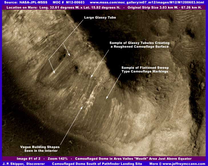
This elongated contoured dome is located right at the top of the MOC # M12-00603 image strip. The second image as follows here will back off a bit and show the entire top of the strip and therefore a little more of the environment around the dome while the third context image here will back off much further and show that this dome is actually designed to blend in and be a part of the end of a much longer land ridge form.
Unfortunately, the original image strip cut off a portion of the upper part of the dome that joins with the land ridge system but still does show the bottom terminating end and you see above how this dome curls around and tapers into and blends in with the land mass. This camouflage illusion is very effective, especially from a aerial distance. Note the sweeping markings and what appear to be glassy raised tube forms both large and small applied to the top surface of the dome all designed to break up any smooth dome surface appearance and help it blend in with the land and also subdue telltale light reflections. The large glassy tube pointed out with labeling might even be a egress path for air traffic. We are lucky because it is this camouflage design that has managed to do the rare thing of fooling the automated tampering software so that it didn't get covered up allowing us to get a peek at this example of civilization and occupancy evidence on Mars.
Note that these dome camouflage outer surface workings do obscure the interior of the dome and its contents but also assist us in being able to see the uniform curvature of the dome's elongated outer surface. In the center of the dome, you can partially see into the interior peeking between and partially through some of the camouflage workings at that point and see what appears to be some multistory buildings inside under the dome cover. However, the resolution is far too limited for objects even of larger building size to be adequately resolved into something we can see and be sure of. Still, this gives you an idea of the size of this structure as it covers what amounts to a small city. One thing is for sure, this demonstrates conclusively at the very least to even the most hardened skeptic that this object is hollow with a interior and is certainly not a geological land form.
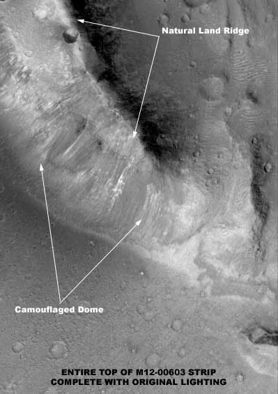
The above second image is the entire top of the original image strip, just with no map-projected borders. It doesn't offer a lot more information but you can see a little better in this original strip lighting its glassy semitransparent surface and how this camouflaged dome was joined to the end of the natural ridge. It doesn't appear that they cut out the end section of the ridge, just sort of attached to the side of the narrow end, tapering into it, and then wrapped snugly in a curve around the natural ridge on the bottom end then merging with the ground looking like a big caterpillar. Although I can't know this for sure, I suspect that the raised sharp edged small crater you seen on the true land form part may be artificial in part or in whole offering a disguised natural looking aerial egress passage point to and from the dome's interior via a underground installation probably tunneled into the true narrow land ridge. Too bad we couldn't have seen just a little more of the top area where the original strip cut everything off. It is quite possible that this dome extends further up the land ridge snuggling up to its side and blending in with it. This may be a small portion of a much larger complex.
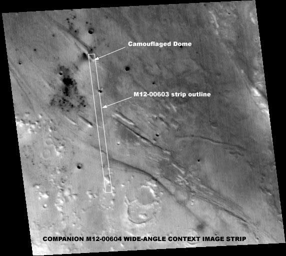
The above third image here is the companion M12-00604 context image strip showing the location of the narrow-angle M12-00603 strip within it. Note the location of the dome as labeled in the image and how it is just a end part of the much larger land ridge. Note also the dark area just outside the M12-00603 strip view to the left of where the dome is located. It is possible that this is a area of water supporting the dome and with even greater civilization evidence at that point but of course we can't know that at such poor image resolution here. Finally, note the other similar land ridges in the surrounding area. One can't help but wonder if there are other domes camouflaged into some of these other natural land forms?
Before I leave you with this, there are a couple of other points to be raised here. For example, there is the question of why this dome is so carefully camouflaged at all? This is not the first camouflaged dome I have come across. Take a look at a early previous report of mine HERE titled "Camouflaged Dome & Water Hole" where I've reported on another camouflaged dome shape and technique similar to this one. The obvious disturbing implication is that all is not peace, tranquility, and enlightenment on Mars when some of those there feel compelled to hide their presence from casual airborne observation while others do not. Or is this just some aberrant paranoid psychology at work here unique to just this particular dome population?
Maybe, but I don't much buy that because I have considerable image evidence of outright ruthless major warfare on Mars that I will be releasing in the future which says it all. In light of that evidence, I think some that are taking these kinds of camouflage precautions may well be justified in doing so and that's too bad. As we have discovered here on Earth, high technology advancement so essential to civilization does not necessarily correlate to any significant changes for the better, at least in human behavior. So, here's a new saying...."As on Earth, as on Mars!" Also, here's a suspicion, are we looking at the source of our own ancestors here? No telling what the future will reveal to us as time unravels these questions and mysteries.
You should also know that the general site of this camouflaged dome is just some miles south of the Mars Pathfinder landing site. Could it be that decision makers knew about this dome from old Viking shots? This is a very dry general area, so with the poorer Viking imaging resolutions, might they have thought that this was a abandoned dome rather than a camouflaged one and chanced including targeting this general area as a landing site based on that? It is not hard to imagine that the condition of the outer surface of this dome might have been mistaken for a debris coating of long abandonment. Maybe Pathfinder's land rover had ranging capabilities beyond what was reported to us and they went looking with it where they shouldn't have and the sudden silence of the land rover takes on a whole new dimension. Unresolvable right now but something to think about and keep in mind.
DOCUMENTATION
http://www.msss.com/moc_gallery/m07_m12/images/M12/M1200603.html: This link takes you to official MGS MOC M12-00603 narrow-angle image strip and its companion M12-00604 wide-angle context strip. I drew my imaging here from the third listed slower loading not map-projected gif strip. However, note that this strip has been flipped both vertically and horizontally at official level and I had to flip it back to the correct orientation in PhotoShop before taking my evidence. The second listed best quality map-projected gif strip does not work or I would have used that in preference. The first listed medium quality sinusoidal map-projected jpeg image works just fine, has the correct orientation, and is perfectly suitable for checking behind me on this discovery but, where possible, I usually try to use the gif strips because of the slight increase in detail over jpeg.
, Investigator
![]()