
DISSECTING A WATER FIND
PART #3
Report #026
September 14, 2001
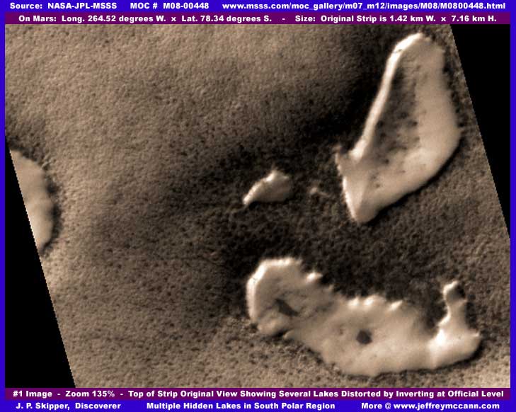
The question for me was what are these light colored large patch areas suppose to be in the first and second images here? Notice how the patches appear to be raised above ground level and how sharp the edges are. This is in the South Polar Region of Mars where everything is supposed to be frozen solid. Are these then suppose to be some kind of unmelted snow or ice banks in a terrain that otherwise shows no obvious evidence of ice or snow? Also, what about that very uniform slightly knobby terrain background? Is that suppose to be ice? Doesn't look much like it to me but it might fool me if I did not already have some experience with the tampering in the MOC imaging.
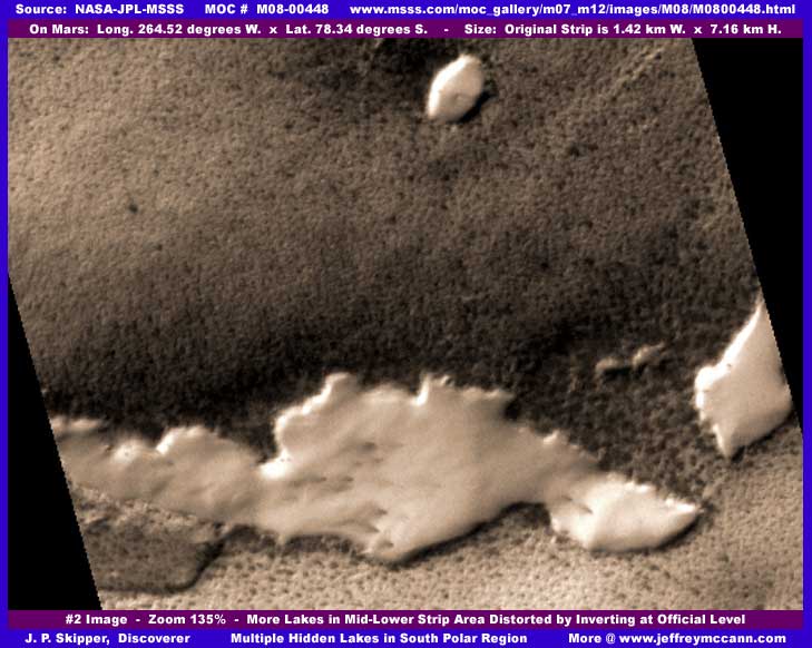
The second image above is from the same original strip showing basically the same type of thing, just at a different location in the strip. I might add that there are a number of these same forms in this same strip not represented in my images here. These are just representative samples. Here again, we have these light colored patches appearing raised above ground level. Unmelted snow or ice fields? If so, this wasn't sufficiently convincing to me and this is where some experience at looking at these MOC images and the natural suspicion that comes with it comes into play. For a example, take a look at my previous M09-02042 report titled "Giant Plants & Lakes of Water" also located in the South Polar Region. Note the 2nd, 3rd, and 6th images of lakes and surrounding terrain in that report and compare them with what you see here and you'll begin to see what I mean.
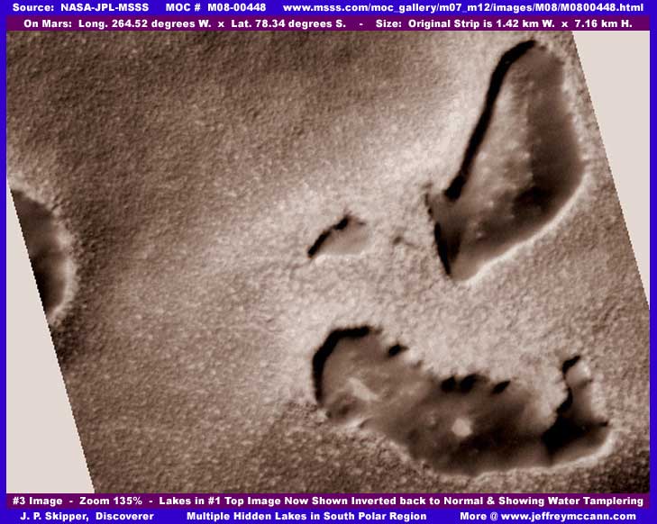
The third image above is actually the first top image here inverted. Now the image begins to make a little more sense. The light colored raised areas now become sunken in areas which, in my opinion, is precisely what they really area. In my opinion, these are in fact quite impossible lakes of liquid surface water. They have received a dark colored fog tampering coating over their entire water surface that becomes the light colored raised patches in the inverting process. In other words, in my opinion, the view presented for public consumption is not actually the normal view but a covertly worked over inverted view presented as normal and my above inverted image just reverts the view back to the true normal view.
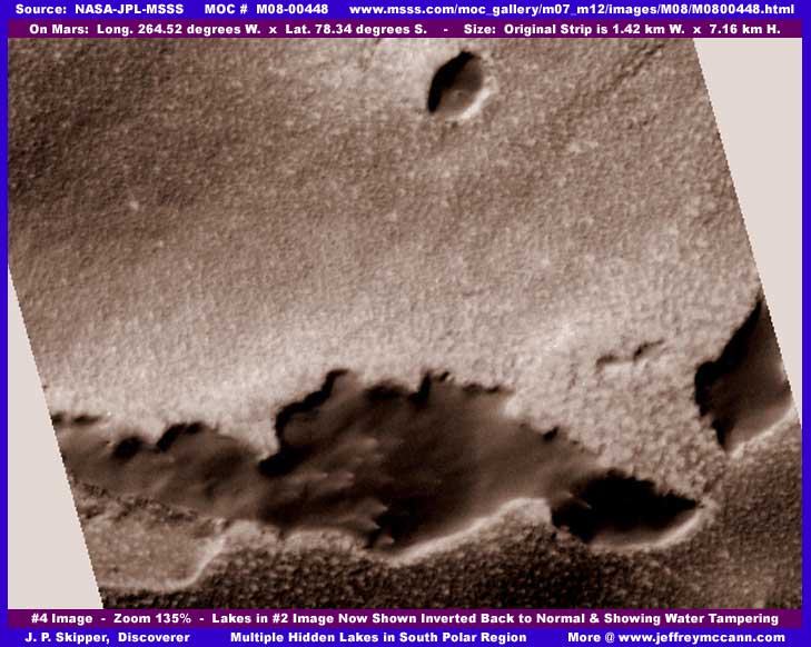
Again, the above fourth image is actually the second image inverted. As you can see again, the light colored raised patch areas now become sunken in areas covered with a dark fog tampering coating. Note in both the third and fourth images here that there is something that has been covered up out in the center areas of each of these recessed areas. I suspect that this was civilization evidence that was out in shallow water rather than at the shoreline that had to be covered up and it couldn't be done adequately without drawing attention to itself. Therefore, this inverting solution eliminating the whole thing. Understand that I can not know this for certain but arrive at this conclusion based on logic, reason, and my own experience with the MOC imaging and the tampering that so often goes with it.
There is another possible scenario that I am suspicious of. As many of you know, I am convinced that those who are doing this tampering have decided that liquid surface water as well as some vegetation is acceptable and approved for eventual future discovery because they have gone to great lengths and much expense to cover the civilization evidence while at the same time trying to preserve what of the water they can for it to be found later. How then does this concept fit with what is happening here in the strip where the water is being covered up completely?
Well, I do have other discoveries of lakes not yet reported on in the South Polar Region without civilization evidence out in the center areas of them as well as the already reported one linked to here in this report. When I release some of those, the comparison with what you see here will be more obvious. In those, the reduction in total resolution of those strips is sufficient enough tampering to take care of any inconvenient buildings evidence clustered along lake shorelines in those strips. If you back off far enough, the distance will cause the buildings to merge into a indistinct mass, jumble, or lines merging in with the land detail. Not so for civilization evidence sitting out in smooth shallow lake water which makes it stick out like a sore thumb. So, to me, it is reasonable to assume that this kind of water evidence is expendable to them in light of the other less troublesome ones in the South Polar Region that they can present without too much hassle.
In any case, here at this probable water discovery, I thought you might like to see another example of how the software inverting process can be used to trick the viewer's eye and creatively alter visual evidence into something else that will pass a brief trusting courtesy examination but not a real in depth analysis. Of course many, including many scientists, will cry foul and say that this is entirely too subjective on my part, that I don't know what I'm talking about, and that I am just some whacked out delusional wannabe. Maybe, all I can say is remember that in many cases it is these same people who have thoroughly demonstrated that they can't find any of the evidence you see here at this web site and for that very reason would be quick to cast doubts on it all. So, is it surprising that they would make such statements?
As always, you must decide for yourself any evidence merit or the lack thereof. I just present it for your consideration. It is quite healthy to question the evidence you see presented here and my interpretations just as it is equally healthy to become involved and question the evidence you have been receiving from traditional sources as well.
DOCUMENTATION
http://www.msss.com/moc_gallery/m07_m12/images/M08/M0800448.html: This evidence was extracted from NASA/JPL/MSSS's original MOC M08-00448 image strip. My data was taken from the second listed best quality slower loading gif strip but the first listed faster loading medium quality jpeg strip will work just as well for anyone wishing to check behind me. On the other hand, the third listed not map-projected gif strip has been flipped vertically and horizontally at official level and you will need the appropriate graphics software to flip it back to the correct orientation if you wish to use that. I have not accessed this data elsewhere such as at PDS or USGS and can not comment on it there. Good Luck.
, Investigator
![]()