
CIVILIZATION EVIDENCE
ON A CLIFF'S EDGE
Report #022
July 28, 2001
As some of you know, it is our policy not to present what we consider ambiguous anomaly evidence even though the definition of what is ambiguous and what is not is often in the eyes of the individual viewer who may well see things differently than we do. In fact, we are sometimes sent evidence of another's discovery that is a solid find of theirs but still just a little too ambiguous by our presentation standards of what we think the average viewer will be able to see even though we do see it ourselves.
On the other hand, in my reports, I sometimes find myself offhandedly referring to the accumulation of all the evidence that I am seeing in my research on Mars and how that impacts my growing experience with viewing the NASA/JPL/MSSS MOC imaging of Mars and the conclusions I reach based on this experience. For example, I often see civilization evidence that is just at the edge of resolution that I am nonetheless satisfied is legitimate even though it is in my opinion too difficult for the general public to see and by that measure too ambiguous to present. Therefore, I thought it would be informative to at least give you a example of this and what I pass over as unreported so that viewers would know where I am coming from when I make such statements. Hopefully, this will give at least some viewers an idea of what I am talking about.
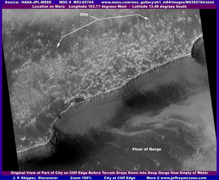
The below first image here is an example of just such a image chosen because it is rather dramatic being on the edge of this sudden great drop in the terrain. It appears just as it does at the official Malin Space Science Systems (MSSS) web site without any enhancements by me and you can see the edges of the image strip are included. Even though the terrain approaching this cliff drop off appears to be covered only by a jumble of tiny light colored vague forms that one might assume to be rocks or some other form of natural geology, it is actually only a limited view of a part of a dense civilization complex that sprawls for miles along this canyon cliff edge. I say this because there are other MOC images of the same locale including other nearby canyons demonstrating this, but for the most part they are of lesser quality than the one you see here. So this is just a sample of the area.
Now the second image below represents a roughly 50% increase in zoom and also has some very slight image clarity enhancements on my part. Frankly, the improvement in view quality is not much better due to the poor official resolution but maybe just enough that some of you may be able to see that the light colored jumble is now beginning to resolve itself not into geology but into individual densely packed buildings. Further, more zooming in on these structures results in them being of course significantly and increasingly blurred but at the same time also clearly resolving into masses of organized individual rectangular forms consistent with buildings and not geology.
Even in the blurry poor resolution second image below, many of you will still be able to clearly see the buildings as geometric structures just beginning to resolve themselves as such. For example, take a look at the structures in the lower left corner perched right on the edge of the cliff and note the two sets of straight abutment walls forming part of the cliff edge pointed out with arrows. Note one wall is lower and right off a great courtyard surrounded by high buildings that may be a citadel of some kind or possibly some kind of great resort complex. Note the building at the lower left corner of the complex right on the cliff edge and the higher level straight wall extending out from it off the image. Just think about the view out over and down into this huge abyss! Obviously, aesthetics are important to these people.
The bottom line here is that someone is on Mars and we are being kept in the dark about it. At some point, you have to ask yourself, is this how you want your tax dollars spent? Is this how you want the people whose salaries you pay to serve your interests? Does this sound like a free democratic society to you? Are you content to let others call all the shots for you and keep you in blissful ignorance. Do you even care? You must decide.
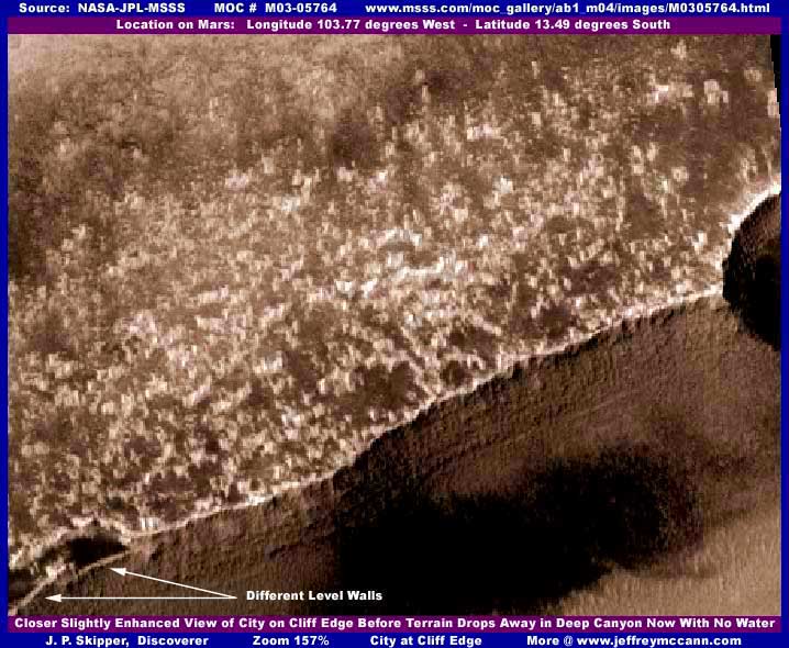
Of course, where ever there is civilization evidence on Mars, there is always image tampering. At the top of the above image is a dithering fog tampering treatment over what is probably larger buildings that we might have been able to clearly see even at this poor resolution had the tampering not hidden them. The software has also seen a few structures and groups of structures scattered around in the light colored jumble that it didn't like and so treated them with individual splotches of medium to dark colored tampering to hide them and help confuse the eye on the whole scene.
Also, the entire view has also been subjected to a semi-clear geometric artifact pattern treatment that blends in and effectively degrades resolution further on the smaller objects like the city buildings still left exposed while at the same time leaving the much larger object cliff edge line still seen in reasonable detail. What can I say, the tricks of the trade and it's just a matter of high math and software design. The mistake on their part was to leave any of this visible at all rather than just depend mostly on poor resolution to keep the portion left exposed from being recognized for what it is. It is mistakes like this, only of better quality, that I occasionally am able to pick up on and report on for you.
This clearish geometric artifact pattern can be seen lower down the cliff wall if you look very very close in the smooth areas but you really have to have a fair amount of experience with this kind of pattern tampering overlay in order to recognize it. In other MOC images, I have seen darker shades of this type of treatment literally replace, completely hide, and mimic ground detail forming a very effective illusion that you are looking at real terrain detail.
The base of the cliff wall where it appears to meet the floor of the canyon is not real but excellently blended tampering and nothing of the canyon wall vs. floor junction can be seen there at all. Likewise, the large dark area on the lower half of the wall appearing to extend out onto the canyon floor is entirely image tampering treatment just in case anyone might be tempted to think it is a water weep area and nothing can be seen through it.
The light patch in the lower right corner on the canyon floor is actually yet more light colored buildings with a treatment of light colored fog tampering mixed in with them to make the whole diffuse and confuse the eye so that the viewer will make the assumption that it to is natural geology. This illusion is made more effective due to the fact that this is down on the canyon floor and further away from the camera already made critical by the main upper level building evidence being the targeted edge of resolution focal point beyond which anything same size visually degrades rapidly.
Obviously, this big civilization complex started out on the high ground when water was in this wide deep gorge or canyon drain system and then migrated to the canyon floor when the water drained away and was drying up. This particular large area of Mars represented in Chart #17 at MSSS's site shows much evidence of a lot of water now dried up flowing and draining across the surface in many crisscrossing great relatively shallow courses. This deeper canyon system and others like it are one of the last places in this general area on Mars where there may still be a little minor surface water to support a desired life style such as down in pits deep below the surrounding terrain level such as this canyon floor.
With that thought in mind, it may be possible that civilization evidence at the top of the cliff may no longer be viable having been abandoned and the population migrated to the canyon floor. However, from what little I can see of the condition of the main complex at the top of the cliff system, I think it is more likely that this is still a viable functioning civilization area at both levels that is still able to tap into probable underground water.
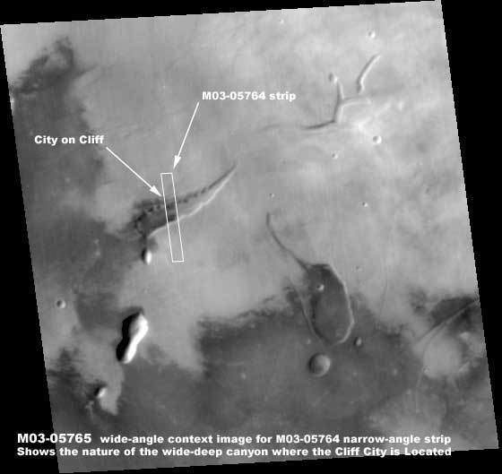
Above is the companion M03-05765 unenhanced by me wide-angle context image just to show the nature of the wide deep gorge-canyon system and where the civilization evidence shown here is located on it. One point!. Dark areas such as you see in the above context image sometimes mean at least some measure of moisture in the soil but most of what you see in the above image is tampering mixed perhaps with some minor legitimate dark areas. The bottom line is that you can't trust these dark areas to be legitimate, so suggest you don't draw conclusions based on them.
In any case, I thought I would share with you what I often pass up and do not report because I consider it to be too ambiguous for too many viewers in the general public to properly recognize. Each of you of course will draw your own conclusions as to this evidence's merit. Right now I'm toying with the idea of occasionally presenting just little more of this type of select borderline ambiguous (& labeled as such) but still telling evidence if I think that enough viewers can see it for what it is. We'll see.
DOCUMENTATION
My 1st and 2nd images are from the official NASA/JPL/MSSS original MOC M03-05764 narrow-angle strip and the 3rd from the M03-05765 wide-angle companion strip. Both at http://www.msss.com/moc_gallery/ab1_m04/images/M0305764.html. Both the first listed medium quality faster loading sinusoidal projection jpeg and the second listed best quality slower loading sinusoidal projection gif strips work and have the correct orientation. However, be forewarned that the third listed not map-projected gif strip has been flipped both horizontally and vertically at official level which can cause considerable distortion. Although it works, proper viewing will require you to have the software that will enable you to flip it back to the proper orientation. Note that in both the M03-05764 narrow-angle and M03-05765 wide-angle sources, I took my data from the second listed best quality gif image strip. I have not accessed this data elsewhere such as PDS or USGS and can not comment on it there. Good Luck.
, Investigator
![]()