
GREAT FISH SYMBOL
& MORE WATER
Report #016
February 16, 2001
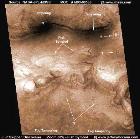
This evidence is extracted from NASA/JPL/MSSS's original MOC #M03-00586 narrow-angle image strip. The above scene is dominated by a downward two step grade from the top of the image to the bottom. Each step forms a great cliff face. As you can see above, the most striking anomaly here is the great fish symbol located in the more level transition ground between the top and bottom topography steps. The MSSS statistics page for this image indicates that the original strip's width is 3.14 km. By my calculations, the fish symbol occupies 51.16% of the width of the original strip. Therefore, this fish symbol is 3.14 km x 51.16% = 1.6 km or 1 mile long from front end to tail end.
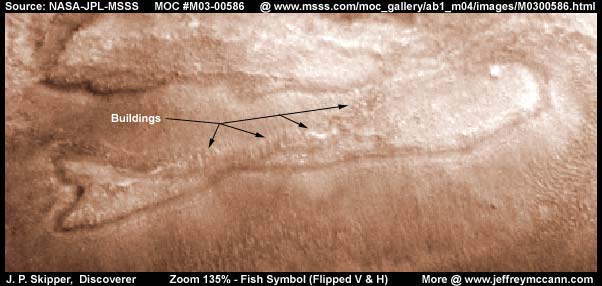
Above is the zoomed fish symbol image flipped both vertically and horizontally. The flipping distorts the surrounding land topography quite a bit but not the fish image very much at all. In fact, the image can now be seen a little more clearly in some respects and the eye in the front end can now be seen much better. This demonstrates the fish symbol's uniformity and, although this is not the MOC image strip's true camera angle orientation, nonetheless this view is the fish symbol's normal orientation and the direction from which it was meant to be seen from the air.
As you can see, the fish image is accomplished on the ground by excavating a long continuous trench that loops back and crosses itself very similar to the way the ancient fish symbol here on Earth is drawn or carved. Could there be a connection? Here on Mars this land form design's original purpose was probably two fold, one to form the fish image and two to produce a trough to hold water. Unfortunately, the resolution is not good enough to allow us to be sure but it looks as though there is a probable long line of multistory buildings along the fish's back trench.
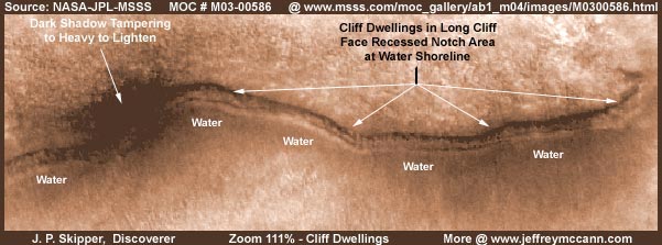
In the top context image, above the fish symbol, something at the base of the top cliff face has been hidden by two large dark black areas of image tampering. These two areas certainly are not true shadow since they wrap around on top of cliff which of course is impossible for shadow to do. In my experience, this is usually shallow standing water at the base of such cliffs where tampering is present and civilization is usually there with it. This turns out to be the case here as I have defeated most of this tampering with extreme lightening so we can see behind it. Remember that the fish symbol is at least a mile long and the cliff face is longer than that.
As expected, here can be seen very shallow water at the base of the cliff and a recessed notch area excavated out of the cliff face right at the cliff base and water line. Although the resolution is insufficient for you to properly see it, there are buildings all in this recessed notch area. This is typical of the living solution this culture prefers and I have seen it often in these MOC images in cliff systems where water is present at the base of cliffs. I have also seen where they will literally excavate a ring around the entire base of a great plateau or land form just as long as water is present at base. The tampering is on to this very well and you will typically see a sweep type tampering that tries to mimic ice sheets at the edges of the land form. This kind of tampering is very successful and can be seen over and over again in these Mars images.
Now note the two anomalies in the above image located to the right of the fish symbol in the top context image. The bottom one is probably a single multistory building set in a rectangular excavated hole and note that it has a overflow drain built into the bottom down hill corner. The top anomaly appears to me to be a rectangular "pillow" shaped small dome set down inside a rectangular hole with sloped sides excavated to fit it and note it also has a water drain in the bottom down hill corner.
Assuming the MSSS statistics page data for the MOC M03-00586 image is correct, by my rough calculations, this rectangular pillow dome is about 480' wide horizontal orientation by 720' long vertical orientation. This gives you an idea of the scale involved and just how fat an object must be to have a chance of being seen here at all. This is why tall narrow high rise buildings with smaller footprints looking down on them from above can not be seen well in these images at these resolutions. Even an object 480'W x 720'L cannot be seen all that well, certainly no real details.
I suspect that the key to what is going on with these two constructions, as I have come to learn is always the case on Mars, is water. As I have stated over and over again, on Mars water is life itself and to the people there it is especially revered. I do not yet have enough evidence to speculate that they are in fact a partially aquatic life form but I can certainly say with confidence that they are most definitely a aquatic oriented life form. The focus on water is a part of their everyday lives. If they are a race that was on Mars at the time of the great change, then the loss of so much water may have triggered a deep rooted trauma reaction resulting in obsession. On the other hand, they may have a more ancient full aquatic past to. It will be interested to one day learn more about this.
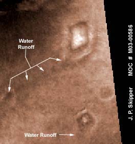
Meanwhile, with these two anomaly constructs, the operative phrase is water saturated ground. I suspect both of these structures are sitting in holes excavated just down into the water table so that it comes up around the bottom of the structures. As excess water overflows naturally and/or is purposefully flushed, it exits via the bottom corners to gradually return into the ground's down slope. The lengthy shallow ravine eroded into the ground by the water overflows from the pillow dome's hole area is clearly evidenced in the above image by the arrows.
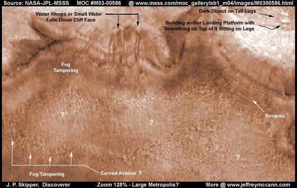
The above image is the scene of the second step down cliff into a more level basin floor below. Two anomalies in the upper right corner are significant. You have to get your eyes down close to the screen and view these two extraordinary but small items. One is a tiny dark vertical oriented strange object sitting up on very tall legs looking sort of like a mushroom sitting on a tall raised platform, all the same dark color. You have to look very close to see it. The second is a rectangular building with a flat highly light reflective top that I suspect is a landing platform for aircraft but of course I have no way of knowing this for sure. There is a object sitting on top of the platform on some fairly long legs that may even be an aircraft but it also might be something else to.
Other interesting items here are the series of dark water fall stains down the face of the cliff wall to left of center and the series of terraces sculpted into the cliff face to the right of center no doubt to serve as water catches. There is a lot of color blended fog tampering all along the face of this cliff. Note the notch all along the cliff face at the same level. I suspect that this was the water level in some bygone day. I've come to learn that where a waterline meets a cliff this water culture on Mars creates these notches along cliff faces at the water line and place their buildings in them so the bases can sit in the water. While we can make out the notch line, the tampering has anything else hidden both at this notch line and at the base of the cliff where the water has now receded to.
Now the physically largest anomaly to report in this image is also a bit ambiguous. In my opinion, at the base of this cliff spread out all over the basin floor is a big metropolis of densely packed buildings. Unfortunately, individual buildings are too small at this resolution to be seen properly and their being densely packed for the most part without wide enough separating roadways contributes to this. Still, the rectangular shape of many of the buildings can at least be seen and, as is pointed out in the above image with arrows, one wider curved avenue can be seen. Future exploration will resolve this if the truth is ever told. If not, history as the final judge will eventually confirm this.
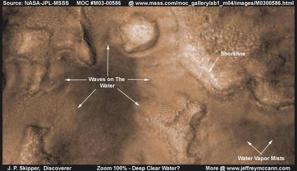
I am disappointed that I could not get a good image of the ripples or waves on this water because that means that this water discovery is going to cross over into the ambiguous a little too much. Still, it is water and I am compelled to report it, if for no other reason than for posterity.
The arrows point out areas of the water surface ripples but they are very faint in this image and hard to see. Part of that is because they are transparent and faint to start with and part is because of the slight loss of detail in this web compressed image. Still, if you get close to the screen, you can make them out, especially as pointed out by the top arrow. Of course skeptics will say these are ridges on dry ground and no water is present at all. But, I've examined this closely and have determined that the ridges run straight across many ground land forms irregularities without influence. That is consistent with these ripple forms being above ground and that means on the surface of clear water.
Most of the larger land forms that you see here are underwater. The darker areas are deeper and the light areas of course more shallow. However, many of these dark areas appear to me to be image tampering which also covers up the wave ripples. The very light bright areas are sticking out of the water. You can clearly see faint water vapor mists hanging over the water, especially to the right in the above image. Now take a look at the shoreline marked with an arrow. I can not be certain about this but there is some evidence that the current water line may perhaps be higher on this shoreline bank (labeled) than it has been in the past because it may be above one of these cut notch lines in the bank (cliff) face. It may be that this area is experiencing a fairly recent higher water level than has been the case in the past.
If this whole area has been recently flooded but still had time to settle, that might explain why all this water is so very clear. Notice the large rock formation in the very top center of the above image. Note the way the ground level out all around the rock tapers down to the base of this land form. Could a upwelling of water (a spring) be causing this by pushing the land away from the rock base in this fashion? Could this actually be one of the major sources of all this water? Or is it part of a older construction when the water was very low and is now under water?
One thing I can tell you, the above image of water is just a small sample of the wide area of water that is in the whole bottom area of this image strip. Unfortunately, because of its clarity and almost straight down viewing angle, it is just as ambiguous as the above image or even more so as far as getting a image of it and so I have not bothered to try and show it to you with yet more ambiguous images. The amount of water volume involved here is quite impressive and suspect that this is also true of the even wider area beyond the confines of this image strip. We'll see what future exploration and history has to say about this area.
I must tell you that the great majority of this whole image strip shows extensive ancient civilization ruins archeology mixed with newer structures including smaller domes. Unfortunately, all are just beyond the necessary resolution that would enable me to bring them out plain enough for you to see properly. I think that much of the old ruins have to do with simple age but also with picking up and abandoning older structures a little prematurely in favor of newer structures continuing to follow changing water levels.
DOCUMENTATION
http://www.msss.com/moc_gallery/ab1_m04/images/M0300586.html: The evidence here is taken from NASA/JPL/MSSS's original MOC M03-00586 image strip. I down loaded the 2nd listed slower loading best quality sinusoidal gif image strip and extracted my evidence here from that. For those who just wish to quickly check behind my work, the 1st listed faster loading medium quality jpeg image strip has the same orientation and data and is quicker to load and view. Warning! The 3rd listed slower loading processed but not map-projected gif image strip has been flipped both vertically and horizontally at official levels before being released to the public. That distorts images significantly except for the fish symbol and I suggest avoiding it. I have not accessed this data at PDS or USGS and can not comment on it there at those sites. Good Luck.
, Discoverer
![]()