
CANYON WATER TROUGHS
& ONE IS NUMBERED
Report #014
January 30, 20001
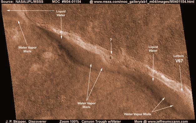
This standing liquid water evidence on Mars is extracted from NASA/JPL/MSSS's original MOC M04-01154 image strip and is one of the water discoveries that I have been holding back for some months. As you can see in the above image, this is a long canyon trough system extending from one side of the image strip to the other with water in it. Water vapor mists can be seen rising all along this water system.
The resolution in this image strip is not going to allow us to get a much closer view of this water evidence. But, I do want to point out the faintly seen vertical ridges down the bottom area of the far bank in the far right water hole section. These are the ridge forms that are formed by micro organisms in the water that I have previously reported on. Their presence indicates that there is some water flow down this particular bank and probably the presence of a spillway with the canyon trough serving as a catch system. The white diffuse coloration just above the ridge forms is not bare bank reflecting sunlight as one might assume but a light colored image tampering possibly hiding geometric structures at the top of the spillway. Likewise there is a continuous line of darker image tampering on the near bank and waterline along this whole system no doubt covering more geometric shapes like buildings.
While we are on the subject of image tampering, the darker colored wider area terrain you see above and below this water trough canyon system looks entirely natural at this zoom in this view. However, when zoomed in very large, this actually appears to be a uniform solid carpet of image tampering consisting of tiny geometric shapes. In other words, I believe that most of this topography is not real except for the canyon trough water system which they have left alone except at the edges and apparently want found. Of course, the topography looks very real in the above 100% zoom and many will think that I am full of something unmentionable here. Still, this is what I see and I am compelled to report it. Anyone willing to go to the trouble of blowing this image up to maximum levels will see what I am talking about. This is an example of their not just covering up evidence but literally artfully creating terrain.
If you do go to the trouble of trying to check and see if what I am saying is true, here is a tip. You will find that the original strip has a gray haze coating on it giving the whole strip a look as though you were trying to view everything through a uniform gray mist. The solution to this is to use contrast as I did in PhotoShop 5.5 and the view will clear up substantially.
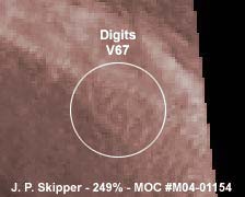
The most telling evidence that there is a civilization presence here is the digits "V67" appearing in the far bank just above the water level in the far right water section. The automated tampering software appears to have missed this little item. This writing is very large and would normally be seen sharper than here but it is partially covered by these water micro organism ridge forms down the bank or spillway and that is breaking up its outline a fair amount. That also may be what threw the tampering software off of this? As amazing as this is, it is self explanatory with clear implications and there is little more I can say. You must decide its implications for yourself.
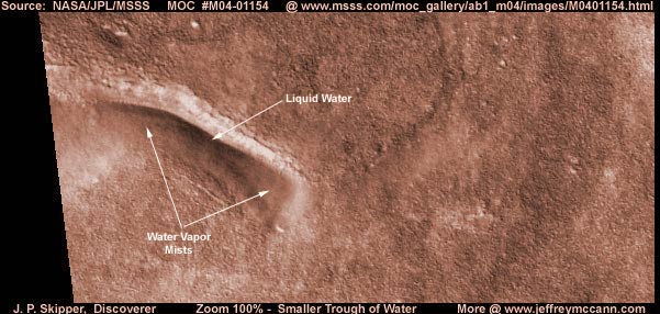
Above is another water hole in this same image strip. In fact, the general area for many miles around this image strip's location contains a fair number of canyon trough water holes like these two providing me with a number of water discoveries. I reported this one here in my Investigative Report section because it did contain the extraordinary "V67" civilization evidence and I wanted to make sure this was brought to your attention and not overlooked in just a mere listing of my various water discoveries. As with the bigger trough system reported on above, this one also has a strip of light colored image tampering along the top bank and a darker colored strip of fog type tampering along the bottom bank meaning the probability of covered up civilization evidence. The surrounding wide view terrain also appears to be the same geometric tampering described above.
For those who will wish to insist that this darker deeper water is actually shadow, please note that this image can be lightened until there is almost nothing visible because it is so whited out and this dark water remains unaffected. True shadow would have responded to this lightening to a significant extent but this dark water remained unaffected.. Therefore, it is obviously not shadow. If it is not shadow or water, then the only thing left is image tampering which is possible. I believe that they do want this kind of "water only" evidence found and that is incentive to apply a dark shadow treatment here in this hole which I have seen often in other images. That dark shadow also would not have responded much to the severe lightening test and it would be very hard to tell the difference.
However, if they created this, then my complements to them because they did a nice job of adding the clearly seen thin water vapor mist coming out of this hole. Further, as I said above, I have a number of other very similar canyon trough water discoveries in other image strips coming from this same general area. These cracks/canyons/troughs are a legitimate feature of the landscape in this general area and are most definitely real as are the ridge forms at the water's edge indicating the presence of water. Finally, the covering tampering all along both sides of the "water" where I have come to expect civilization evidence to be, is not something they would have gone to the trouble of doing unless that civilization evidence was actually there and that evidence would not be there if the water was not there. Accordingly, the logical conclusion is that the water is there and not shadow or tampering.
DOCUMENTATION
http://www.msss.com/moc_gallery/ab1_m04/images/M0401154.html: The evidence here is taken from NASA/JPL/MSSS's original MOC M04-01154 image strip. I downloaded the 2nd listed best quality slower loading sinusoidal projection gif image and extracted my evidence from that. The large water trough system is right near the top of the strip extending from one side of it to the other. The smaller but deeper water trough system is located about 90% of the way down the strip near the bottom and on the left. For those interested in just checking behind me for confirmation, the 1st listed medium quality sinusoidal projection jpeg image has the same view and orientation and is quicker to load saving some time. WARNING! The 3rd listed slower loading not map-projected image is flipped both vertically and horizontally for some reason by MSSS which does cause serious image distortion, so suggest you don't use that one. I have not accessed this image at PDS or USGS and so I can not comment on it there at those sites. Good Luck.
, Discoverer
![]()