
WATER, ISLANDS &
CIVILIZATION EVIDENCE
Report #011
12/9/2000 (1st post) - 1/19/2004 (update)
This evidence in this report is drawn from the MGS MOC AB1-08503 narrow-angle science data strip. As you can see in the above first image, this strip is characterized by very heavy and obscuring haze and streaking artifacts. It is probably not coincidental that other images of this particular site are also characterized by even more obscuring haze and streaking. My clarification efforts have managed to partially penetrate this obfuscation to a limited extent as you see above.
You should also know that this site is also located right at the foot of the super colossal size global "The Hand of Power" torrent of rain symbol demonstrated in my report #059 also posted at the same time as this updated older report. While there is a chance that all this liquid surface water at this particular spot at the foot of the Hand of Power symbol is coincidental, that would seem to strain reason just a bit. Likewise, the presence of all this obscuring haze streaking could be coincidental as well but then that would seem to strain reason just a bit to.
As you might expect, I suspect this haze streaking of being purposeful image tampering treatment trying to generally obscure the presence of all this liquid water encompassing a wide enough area to possibly be a sea. The fact that this particular type of obfuscation is confined mostly to this particular site on Mars is I believe significant.
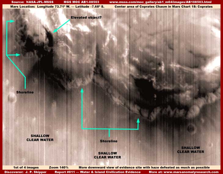
Now the evidence in the above image is admittedly weak because of this obscuring haze but I've included it for a reason. What I want you to note here for the moment is the very downward vertical angle of view of this site. When you've got that fixed in your head, then I want you to compare that to the subtle lower angle of view in the second image below.
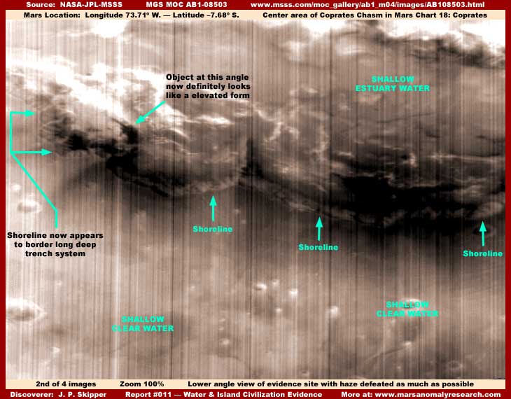
The above second image demonstrates a very subtle lower angle of view than that in the first image and yet these images are from the same source and are suppose to be the same. This demonstrates that there is more than one image and/or the above first image has been stretched to distort it. You can see this distortion by examining the dark elevated object I've identified in both the first and second images and comparing it in each image.
This object is very distorted in the first image taken from one strip but more proportionally correct in the second image taken from a different strip. It actually looks very much like a huge weapon pointing at an angle into the sky. At the very least, this tells us that someone has been messing with these images before their release.
What you are looking at here is an island land form in the top of the image and very clear still surfaced standing liquid in the lower half of the image. The irregular shoreline separating the water from the island land mass is pointed out with arrows and labels.
The land mass contains quite a bit of civilization evidence other than the dark elevated object. But, this is mostly in the form of upright vertically oriented lighter color structures and their shapes are confused with the vertical haze streaking and direct dark smudge image tampering applications so that it is hard to differentiate one from the other. That combined with the generally very poor resolution makes the civilization evidence very difficult to see. So, unlike with my original report where I tried to point this other civilization evidence out to you, I'm now just going to mention it here and leave it at that.
This wide area of flat still surfaced clear water extending out from the land mass in the foreground of the above second image can be seen slightly better at this slightly lower view angle in this more proportionally correct strip. That's because there is a slight reflective quality to the water surface even though this subtle information is confused with the haze streaking. This water is very interesting because it is so clear (water is usually dark on Mars) and shallow enough that plenty of underwater bottom detail can be seen through the water's top surface.
Close careful examination indicates that what at first may look like small impact crater pits are not that but round pit structures with no ejecta fields created so that the water level comes right up to their top edge. In other words, these appear to be round artificially created solid object pits amounting to holes in the water surface. Some of the smaller ones appear to be pits only while larger ones (not seen here) contain vague artificial structures within them.
In the upper left quadrant of the second image above can be seen a long deep trench system that conforms to the irregular shoreline of the land mass. This is characterized by straight and level slopes down and the slope appears to have parallel lines of something on it from waterside top to the bottom of the trench. There appear to be some kind of larger girders arching out from the land mass side of the trench to the opposite water side. The water level itself, like with the rounded pits out in the body of water, appears to be right at the top of the trench top edge on the water side.
In other words, there appears to be a process going on here whereby this trench system and possibly some of the pits out in the body of water act as drains for this water keeping the wider body of water at a prescribed level. Beyond that there is insufficient evidence for speculation.
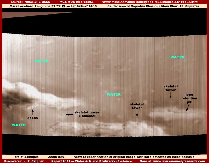
You should be aware that the AB1-08503 strip is a short one vertically because a section of it has been cut out leaving a black blank gap between the larger bottom and small top sections. The evidence in my first two images here were extracted from the larger bottom section. Now the above third image shows the much smaller top section wide field of view. One can only imagine what may have been in that missing largest of all mid section.
Here again in this top section we have different and smaller lighter color island land masses in a darker wide body of relatively shallow water. The view here is more distant and fuzzier because the scene is a bit more distant as is often the case with the tops of strips because of the curvature of the planet's surface relative to the satellite camera orbital path.
Other than the wide area sea of water in this maritime setting, one of the most interesting features is the long narrow rectangular retention pit elevated well above the surrounding water surface level located in the lower right corner of the image. Let's take a closer look at it below.
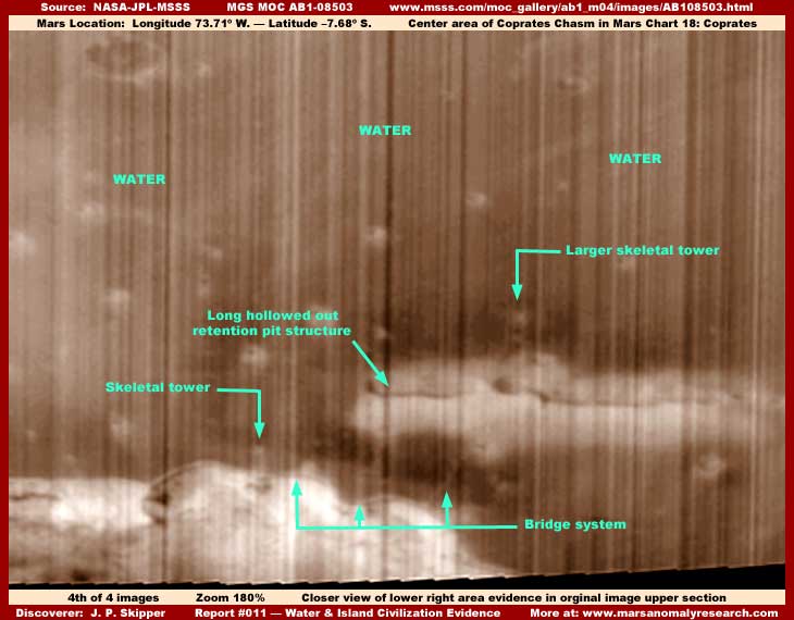
The fourth image, like all the other images from this strip are heavily occluded by the haze streaking but some interesting even if faint detail can still be seen as pointed out by the arrows and labeling. Perhaps the most obvious anomalous evidence is this light color long rectangular retention pit on the lower right with its sides rising out of the water. It is large enough to be seen a bit better through all this haze streaking.
It appears in this blurry imaging to be a long elevated natural land form modified by hollowing out down its length to form a long rectangular retention pit inside with elevated perimeter walls. The near side wall throws short shadows into the depths of the retention pit and the shadows can be clearly seen. However, the light color over saturation of this form and the destroyed finer detail because of that and the light color area merging into itself could be concealing a long row of individual structures rather than being the sides of a natural land form, so keep an open mind about this even if they can't be seen here. On the far side of the form seems to be a large tall open skeletal tower structure.
It is very faintly seen in this poor resolution but there is also a connecting bridge looking system of some kind that crosses the dark area separating the background light color form from the light color land form in the foreground bottom edge. It is also an open skeletal structure making it especially hard to see. Once across the water and onto the near side land form, the elevated structure turns to our left and continues on a ways to the left on this land form loosing its visual integrity in the highest elevation of the land form where a shorter skeletal tower is also located and pointed out.
Except for the dark elevated form looking sort of like a barreled weapon and the trench drain system in the second image here, the main evidence here is the wide area of standing liquid surface water poorly seen at the limit of resolution and in spite of this haze streaking. The fact that this wide area body of water is at the foot of the Hand of Power torrent of rain symbol is I suspect not coincidental.
Even though the evidence we can see here is important in its impact from our newly awakening point of view as to surface water and what may be on Mars, I suspect the most obvious evidence that could not be concealed by haze streaking was chopped out of and eliminated from this strip as represented by that dark black gap between the strip's bottom and top sections. Considering that super colossal Hand of Power and torrent of rain symbol in my report #059, I can only image what kind of huge size evidence may have been eliminated.
Even though this evidence is poorly seen, remember the presence of this heavy obfuscation in the imaging confined essentially to this site. This is itself the tip off as to what we think we are seeing here and what others do not want us to recognize. In my opinion, its presence confirms the visual interpretation.
SUMMARY POINTS
(1) The primary evidence is a large wide body of clear standing liquid surfaced water.
(2) This liquid water being at the foot of the "Hand of Power" symbol is significant.
(3) Liquid water presence undermines official positions on temperature on Mars.
(4) Some scattered civilization evidence indicates this site is or was occupied.
(5) Very heavy haze streaking occlusion implies support for anomalous evidence.
(6) Removed section of strip fuels speculation that significant evidence was removed.
DOCUMENTATION
http://www.msss.com/moc_gallery/ab1_m04/images/AB108503.html: This link accesses the AB1-08503 original science data strip at MSSS. If you go there, please note at the top of the lower section that the forms there are the same forms partially seen that are also the same as those seen at the base area of the global Hand of Power symbol confirming that this evidence is in the same location. However, in both cases, I suspect that image tampering in the topography may have helped create these shapes.
Also, note that the land form shapes in the top section above the image gap are not part of the Hand of Power itself. That imagery is located a little further to the upper left (northwest) of that point and not visible in this strip. The haze and streaking is very heavy in the science data strip fairly thoroughly handicapping any view of evidence, so graphics software will be needed to partially penetrate through this mess to gain better views comparable to my images above.
, Investigator
![]()