
WATER INDUSTRIAL SITE, et al
Report #006
8/2000 (orig post) - 1/17/2001 (1st rev) - 8/22/2003 (2nd rev)
The civilization evidence here is my third report to be drawn from the NASA-JPL-MSSS official MGS MOC M02-00163 narrow-angle image strip. As previously reported, this strip has produced the most numerous anomalous evidence so far for me of any single strip I've yet encountered in the official science data. Also, the colossal size evidence seen in the companion M02-00164 wide-angle context strip as per my report #003 titled "Colossal Head & Animal Monuments" was the red flag that drew my attention to this narrow-angle strip and I believe that this red flag treatment was made available intentionally by someone not complying with the party line within the secrecy insider group as explained in that report.
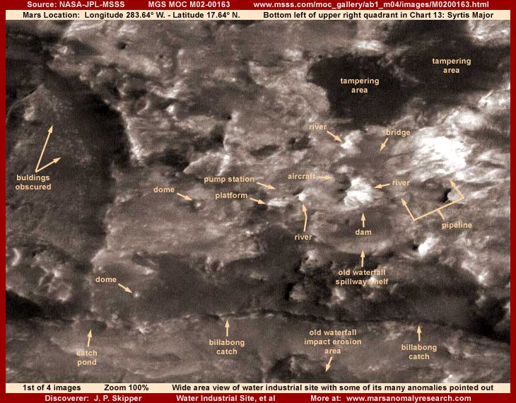
This M02-00163 strip is a big one that appears deceptively clear at the the official 100% resolution as appears in my above first image. However, before being enlarged, the overall evidence in this strip has been subjected to extensive obscuring direct application image tampering as well as general resolution tampering. The result is that zooming in very much in this strip quickly runs into resolution degradation problems and fuzzy images.
Some key pieces of evidence, such as the elevated height pumping station sitting on top center of a huge also elevated height enclosed platform-building type structure supported by massive legs as pointed out by an arrow and label in the first image above, have been left out of the totally obscuring type tampering and we can get a decent look at it. But other evidence I'm reporting on here in this busy scene has been partly or mostly obscured by tampering applications. Unfortunately, it is the nature of the beast in this satellite imaging as released to us.
Here is what I think is going on in this scene so busy with tiny size evidence. There is a fairly severe slope in the terrain downward from the top of the image to the bottom. From within one of the two very dark image tampering areas in the upper right quadrant of my above first image comes a white water river system forming a naturally eroded gorge as it comes down the slope. It appears that in the past this river originally came down and shot out over the upper terrain cliff edge shelf as a waterfall into the lower terrain below.
The dark line I've labeled a Billabong water system running horizontally across the lower part of the image is basically the dividing line between the base of the upper terrain cliff overhang and the beginning slopes of the lower terrain. Most of the evidence all in this area is heavily obscured with multiple direct image tampering applications.
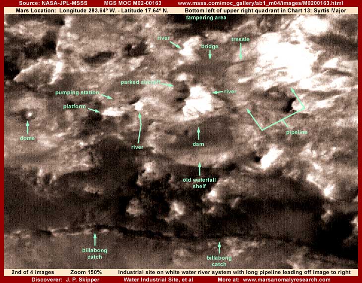
I don't expect many to be able to see much of this but, at some point in the distant past, someone on Mars has come along and artificially dammed the river system on the upper terrain level just short of the old waterfall drop off and diverted the water flow into a circular pattern from our right to our left. As seen in the above second image, in the center of this white water circular flow pattern wrapping around its base is a high projecting form sticking at a slight right angle out over the widest part of the white water gorge. The dam that is just below this point forcing the white water into a circular pattern around the base of this projecting form can't be seen because of direct smudge tampering applications obscuring it.
Note above how this "pedestal" form the aircraft is sitting on is very rounded and contoured. It is unclear whether this object is a natural or artificial construct but I suspect this rounded contoured form so different from the other more irregular features of this terrain it sits in is probably artificial or natural rock artificially carved into this shape. The really interesting thing is the round bell shaped object sitting on top of the pedestal that looks very much like and is sized the same as the aircraft in flight presented in my report #004 titled "Aircraft, Buildings & Other Anomalies." It should be noted that this aircraft in flight is only a short distance away in this same region. Take a look at that previous report and compare for yourself.
In any case, even though the imaging is blurry and grainy, the most obvious anomaly evidence here is the large elevated height industrial skeletal structure type pumping station. This high elevated structure in turn sits on top of a massive elevated height enclosed platform structure supported by huge legs on the side facing us to sit level in this rough sloping terrain. Both of these objects are very geometrical in shape and there is no chance that the automated tampering software would have missed covering up this type of object unless there was a temporary breakdown in its programing or someone intervened and prevented it from doing its thing.
If the latter, that suggests to me that this object was very probably a part of a number of evidence items intentionally left out of the the most obscuring of the tampering applications (still subjected to general resolution tampering) by someone interfering with the software applications. This is just the same as is the case with the colossal monuments in the companion MO2-00164 context strip drawing attention to this area were purposefully left out.
Although seen only faintly like looking through a fuzzy filter, a huge pipeline extends at an angle down from the elevated pumping station height taking advantage of downward gravity flow for a boost and then curves around across the top of the dam for support and then extends arrow straight across the terrain to our right. We can see parts of it in those places not completely obscured by the image tampering applications. It is likely that a pipeline large enough for us to see at all in this distant poor resolution satellite imaging is massive and probably pumping a tremendous volume of the river's water to some very large civilization or other processing industrial center to the right and unseen off the edge of the strip.
Another discovery in evidence here is a bridge and trestle system spanning across the white water river gorge as pointed out with arrows and labels in the above first and second images. This is located just above the aircraft parked on pedestal site. The roadway that extends off into the terrain to the left from the bridge system is too small and is seen only as a faint broken up but still identifiable arrow straight line. To the right of the bridge center the roadway is a straight trestle crossing the gorge to the gorge's slope to our right and beyond that it disappears quickly into some over saturated very light color ground there and can no longer be seen.
Unfortunately, this object, although large enough to be vaguely see here, like most bridges we are familiar with is probably entirely a skeletal structure and such evidence without broad solid reflective surfaces shows up as only very faint and very fuzzy in this poor grainy distant satellite resolution. Additionally, this object also appears to have received some smudge obscuring direct application smudge tampering treatments put on the main center part of the bridge as well.
Obscuring direct tampering applications are present all in most of the surrounding terrain in many different spots and areas. This whole dam as well as the cliff slope area below it down to the Billabong system and all across the image has been subjected to and obscured by extensive direct different colored multiple tampering treatments. So, even though some evidence has been left out for us to see, it is still partially obscured by these treatments and adding to the observational problems created by this tampering is the fact that this scene is so busy with bits and pieces of anomaly evidence that it is difficult to get adequate focus on it all or discuss it all here. So I'm covering here only the main evidence that I think some may be able to recognize, not all the evidence in this scene.
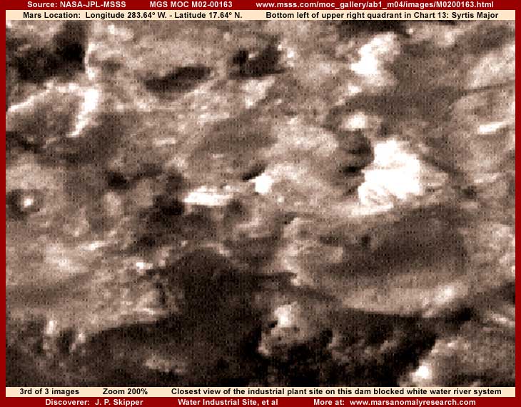
In the above third closest view image, I've left out the distracting arrows and labels trying to give you a cleaner and a little closer view of the main evidence in this poor quality scene. The view is far too grainy but, if you can pick them out without me pointing them out with arrows and labels, it does provide a slightly better view of the too over saturated light color white water and its gorge, the bridge and trestle system, the parked aircraft, and the elevated pumping station and its platform. Most of this evidence in this very grainy resolution with the extensive tampering applications is admittedly tough to interpret. If you don't try to see anything else in these images, do try to pick out the white water river and pumping station.
As does other evidence in other reports I've reported on coming from this particular strip, the accumulative white water river evidence in those reports same as you see here tells us that Mars does indeed have liquid surface water in places. The existence of such surface water in a liquid unfrozen state tells us that atmospheric temperatures on Mars can not be as severely cold as officially depicted. This in turn means that general environmental conditions would appear to be much milder and therefore much more favorable to and capable of supporting the kind of life we are familiar with than officially depicted.
Further, not only is this environment in places like this capable of supporting life in general, we see specific evidence of intelligent civilized life in the form of the artificial constructs seen here and in the other reports from this strip. In other words, someone is on Mars and we are not alone in this Solar System with all its implications.
I repeat, the presence of liquid surface water evidence points to the obvious conclusion that Mars environmental conditions are just simply not as officially depicted. The presence of the civilization evidence points out to us that Earth humanity is clearly not alone in this area of the Universe. The presence of the image tampering combined with the fact that it targets primarily civilization evidence tells us that some among us know the truth that we are not alone and are intentionally denying us access to this truth.
That means that you and I are intentionally being kept ignorant of a major portion of the truth and reality that constitutes our environment and which already effects our everyday lives in important ways currently unknown to us. It is very probable that every day critical short and long term decisions are made by a select few in secret on behalf of Earth humanity relative to and reacting to this reality hidden from us.
I suspect they think most you want it this way. Are they right? Is living in pretense and ignorance really what you want? Do you want others, most likely primarily military intelligence, to be making such critical decisions for us all without even the slightest input by us and no checks and balances? Do you see this as a good thing? In the Stargate SG1 TV series, this situation is portrayed as and you are conditioned to see this as a good thing but that's just TV fiction where everything always turns out well for us all in the end and that is far different than the way reality really works. What do you really want? You must decide.
SUMMARY POINTS:
(1) The white water river system evidence confirms flowing liquid surface water on Mars.
(2) Liquid surface water evidence undermines official positions on environmental temperatures.
(3) True environmental conditions appear to be favorable in supporting life on Mars.
(3) Evidence like the industrial plant confirms civilization life evidence on Mars.
(4) Mars conditions and what is really there is clearly different than officially depicted.
(5) Image tampering demonstrates that Mars truth is being intentionally kept from us.
DOCUMENTATION:
To check behind me in verifying this evidence in the official science data, the easiest to access is at the MSSS website link below. This particular evidence scene is located about half way down the strip right of center and to the right edge. The official resolution view will be sufficient to see the pumping station and the platform it sits on, even if tiny in size, comparable to my first image in this report but graphics software will be needed to adequately examine any of the other evidence pointed out here.
http://www.msss.com/moc_gallery/ab1_m04/images/M0200163.html: This link takes you to the official MGS MOC narrow-angle science data strip that my imaging has been drawn from. There the first listed browser compatible JPEG sinusoidal (angled) strip works but offers a flipped view that distorts the evidence, so don't use that. The second strip does not work. The third listed straight orientation higher quality but slower loading GIF strip does work, offers the same view as the raw official data strip that the scientists see and matches the evidence orientation presented here. Warning! The use of any other strip having a different orientation will distort evidence and generate poor results.
, Investigator
![]()